Printable Version of Topic
Click here to view this topic in its original format
Unmanned Spaceflight.com _ MSL _ MSL Curiosity Lands Safely in Gale Crater
Posted by: nprev Aug 6 2012, 05:38 AM
We are DOWN, ladies and gentlemen...we are down!!!!
This is the place to talk about it.
Congratulations to the MSL team!!!!!!!!
Posted by: dvandorn Aug 6 2012, 05:42 AM
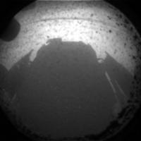
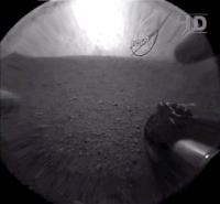
Based on a single 256-pixel hazcam, I can see that we have very few rocks around here. More like scattered gravel and stones. This looks more like what I expected Gusev to look like, more like an ancient lakebed.
Of course, any serious analysis will wait for better images.
-the other Doug
Posted by: Explorer1 Aug 6 2012, 05:45 AM
No dunes, like Emily said.
Easy driving ahead!
Posted by: Big Joe Aug 6 2012, 05:46 AM
Quick grab
Posted by: MichaelT Aug 6 2012, 05:49 AM
Fantastic success to land the rover safely! Fantastic images! Congratulations to the MSL Team and everyone involved! I now hope everything will proceed as planned and that Curiosity is healthy.
Did you guys notice how dusty the cameras lenses have become through the landing?
Michael
Posted by: MarsEngineer Aug 6 2012, 05:49 AM
So folks. What do ya think???
-Rob
PS my heart is still racing and I think my throat is broken.
Posted by: Phil Stooke Aug 6 2012, 05:51 AM
Not too shabby! Should be good for a hundred pages in my new book...
Phil
Posted by: belleraphon1 Aug 6 2012, 05:51 AM
SIX MORE WHEELS ON THE GROUND!!!!
WOW!!!!!! What a night!!!!
What a team!!!!!!
Craig
Posted by: Explorer1 Aug 6 2012, 05:51 AM
I'm drenched... utterly drenched; how about the rest of you?
Posted by: Silmfeanor Aug 6 2012, 05:52 AM

-Rob
PS my heart is still racing and I think my throat is broken.
Amazing. Truly amazing. Congratulations, and I am looking forward to the next decade or so.
Didn't breathe for a few minutes in there.
Best wishes for the work that is to come!
Posted by: MahFL Aug 6 2012, 05:52 AM
It all happened so quickly, parachute, then almost immediately, touch down, awesome. And as for the pics, double awesome !
Posted by: Burmese Aug 6 2012, 05:53 AM
When can we expect the images to get posted the way the MER rovers pics are filed as they arrived, ready for public perusal?
Posted by: craigmcg Aug 6 2012, 05:54 AM
Awesome!
Awesome!
Posted by: nprev Aug 6 2012, 05:54 AM
I think you guys are steely-eyed missilemen, and you ain't gotta pay for your beer when I'm around!!! 
Brilliant, Rob. Congratulations to you & your team seems inadequate; thank you on behalf of humanity.
Posted by: Nix Aug 6 2012, 05:55 AM
we think AMAZING Rob !!!!!!!!!!!!!!!!! Congratulations !!
Posted by: jamescanvin Aug 6 2012, 05:56 AM
No images yet but the raw images page is intriguing:
http://mars.jpl.nasa.gov/msl/multimedia/raw/?s=0
Posted by: Explorer1 Aug 6 2012, 05:56 AM
Raws here (down of course):
http://mars.jpl.nasa.gov/msl/multimedia/raw/
Posted by: Reckless Aug 6 2012, 05:58 AM
Well done Nasa and JPL, Rob and Paolo and thanks. Everything looks brilliant. I'm looking forward to the next few years here at Unmannedspaceflight.com my favourite site on the web.
Roy F
Posted by: gpurcell Aug 6 2012, 05:59 AM
Rob, felt a lot more controlled than Pathfinder or the MERs.
Posted by: Barry Aug 6 2012, 06:02 AM
Cracked a tear, cracked a beer and cracked a god awful cheer...MSL your down there with MER...one of the best moments in my life unbelievable! 
Posted by: ElkGroveDan Aug 6 2012, 06:02 AM
Thanks for checking in Rob. It seems to get better every time.
Posted by: jmknapp Aug 6 2012, 06:04 AM
In the poll, seems like I head someone mention the lat/lon--anyone catch that?
The reported touchdown velocities were amazing--almost no horizontal velocity. The vehicle is tilted only 4 degrees. Masterful job as usual.
Posted by: PDP8E Aug 6 2012, 06:05 AM
Here is a quicky 3x of the front hazcam
|
I think we are pointed due east...
Posted by: imipak Aug 6 2012, 06:06 AM
\o/
Posted by: Hungry4info Aug 6 2012, 06:07 AM
UMSF went down a bit. :C
Congratulations to JPL!!
YAY!
Posted by: Ian R Aug 6 2012, 06:11 AM
I awoke to this most fantastic of news! Well done to EVERYBODY involved!
Posted by: Burmese Aug 6 2012, 06:11 AM
The reported touchdown velocities were amazing--almost no horizontal velocity. The vehicle is tilted only 4 degrees. Masterful job as usual.
They listed some precise lat/lon but I was to dull to think to write it down - I'm sure someone did, though.
Posted by: Chmee Aug 6 2012, 06:16 AM
Good thing they were forward thinking and had those dust overs on the cameras; it looks like a fair amount of dust was kicked up. BTW AMAZING LANDING!
Posted by: Explorer1 Aug 6 2012, 06:18 AM
Now to see what Hirise caught....
And MARDI...
And the other cameras...
Oh man...
Posted by: akuo Aug 6 2012, 06:20 AM
Rob and folks, you make this stuff look easy. Congratulations!
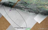
Looking at the trafickability maps modified by Tesh for Google Earth (Mars) with the reported touchdown co-ordinates -4.591817 137.440247. Looks nice and flat.
Posted by: fredk Aug 6 2012, 06:20 AM
Those rocks look small, but then again we're higher up than we're used to, eh!
Huge congrats to everyone involved. I can't wait to join in with you guys and the rest of us armchair explorers as we explore another part of Mars! 

Posted by: Barry Aug 6 2012, 06:22 AM
Cheers to Australia....
Posted by: Tom Tamlyn Aug 6 2012, 06:27 AM
Choking up over my good-luck peanuts and some beer. As usual, couldn't believe how fast it went by.
Congratulations to Rob and the EDL team. And a big thank you for taking the time to keep us posted on umsf.com.
Rob, how about putting in for a sabbatical and writing that book we're all waiting to read ...
TTT
Posted by: Fred B Aug 6 2012, 06:29 AM
Man, the web is slow right now... here are deep links to the raw images:
http://mars.jpl.nasa.gov/msl-raw-images/proj/msl/redops/ods/surface/sol/00000/opgs/edr/fcam/FRA_397502305EDR_D0010000AUT_04096M_.JPG
http://mars.jpl.nasa.gov/msl-raw-images/proj/msl/redops/ods/surface/sol/00000/opgs/edr/fcam/FLA_397502305EDR_D0010000AUT_04096M_.JPG
http://mars.jpl.nasa.gov/msl-raw-images/proj/msl/redops/ods/surface/sol/00000/opgs/edr/rcam/RRA_397502188EDR_D0010000AUT_04096M_.JPG
http://mars.jpl.nasa.gov/msl-raw-images/proj/msl/redops/ods/surface/sol/00000/opgs/edr/rcam/RLA_397502188EDR_D0010000AUT_04096M_.JPG
My rough 3D: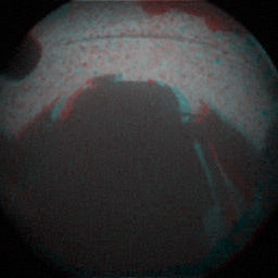
Posted by: lyford Aug 6 2012, 06:29 AM
Party like it's 2004 all over again!
Posted by: jmknapp Aug 6 2012, 06:31 AM
Looking at the trafickability maps modified by Tesh for Google Earth (Mars) with the reported touchdown co-ordinates -4.591817 137.440247. Looks nice and flat.
Here's the location I get from those coordinates:
|
Posted by: Big Joe Aug 6 2012, 06:31 AM
http://mars.jpl.nasa.gov/msl-raw-images/proj/msl/redops/ods/surface/sol/00000/opgs/edr/fcam/FRA_397502305EDR_D0010000AUT_04096M_.JPG
http://mars.jpl.nasa.gov/msl-raw-images/proj/msl/redops/ods/surface/sol/00000/opgs/edr/fcam/FLA_397502305EDR_D0010000AUT_04096M_.JPG
http://mars.jpl.nasa.gov/msl-raw-images/proj/msl/redops/ods/surface/sol/00000/opgs/edr/rcam/RRA_397502188EDR_D0010000AUT_04096M_.JPG
http://mars.jpl.nasa.gov/msl-raw-images/proj/msl/redops/ods/surface/sol/00000/opgs/edr/rcam/RLA_397502188EDR_D0010000AUT_04096M_.JPG
My rough 3D:
Wow 3D already, I love this site :-)
Posted by: Pando Aug 6 2012, 06:31 AM
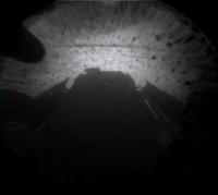
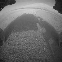
This is just insane. First image down and it's the perfect angle for a self-portrait shadow.
Posted by: helvick Aug 6 2012, 06:33 AM
Admin Notice:
UMSF is getting a wee bit more traffic than we've ever had before ( at least 358 concurrent users at one point vs a typical busy peak of 100) so many of you are getting timeouts. Apologies for this but we're running from a single relatively mature server that is generally way more powerful than we need but is struggling to keep up with all of you guys as you frantically hit refresh to get new posts.
Bear with us - the server is actually fine, just running a bit slow. There's no risk of a catastrophic meltdown and I'm hoping the peak will pass. In the meantime I'm looking at what I can do to mitigate the immediate effects.
Also if you could hit "refresh" slightly less often it will help, no more than once every second would be good.
Posted by: Bjorn Jonsson Aug 6 2012, 06:36 AM
Looks like a nice, smooth landing site where driving should be no problem. Apparently much less rocky than the Viking, Pathfinder and Spirit landing sites.
People seem so happy/elated that the news briefing looks a bit 'chaotic' and difficult to start which in this case is a good thing. .
Big congratulations to everyone involved.
Posted by: Stu Aug 6 2012, 06:37 AM
"Flat"? I'll say...
|
Note: that's NOT Mt Sharp on the left, that's just a result of the distortion filter applied to the image to flatten the horizon.
And looking the other way, forwards...
|
Posted by: Chmee Aug 6 2012, 06:38 AM
So a little down range from center, but realy excellent! Just means less driving until we get to the interesting stuff
|
|
Posted by: ElkGroveDan Aug 6 2012, 06:38 AM
Just spotted Emily at the press conference.
Posted by: ustrax Aug 6 2012, 06:39 AM
day was rising here as we knew Curiosity had successfully landed, needless to say that, as 8 years ago, emotions took over the dawn.
thank you all who made this a reality, love you, really. now...let Curiosity explore!
Posted by: SFJCody Aug 6 2012, 06:44 AM
Congrats to the MSL team and everyone at JPL from everyone here in my workplace! We used the dual projectors in our conference room to watch both the NASA-JPL ustream and the Eyes-On-The-Solar-System simulation simultaneously. In the words of my co-workers, this was "awesome!" "amazing!" "great fun!" and "unbelieveable!"
Looks like they landed long again!
Go humans!
Posted by: volcanopele Aug 6 2012, 06:44 AM
Plus a new abyss for you in the forward hazcam

Posted by: Tesheiner Aug 6 2012, 06:45 AM
-Rob
PS my heart is still racing and I think my throat is broken.
You are WIZARDS!

Posted by: Zeke4ther Aug 6 2012, 06:48 AM
-Rob
PS my heart is still racing and I think my throat is broken.
Amazing, utterly amazing!!!! I am so glad we can be along for the ride!
Posted by: fredk Aug 6 2012, 06:49 AM
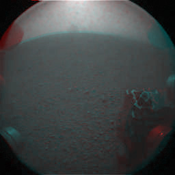
Time for some of us to get to work! Here's my first job with MSL images: an average of the registered L,R rear hazcam view:

|
What's that just left of centre on the horizon? It's in both L and R frames! Could it be the dust from the descent stage crash landing???

Posted by: helvick Aug 6 2012, 06:50 AM
Admin Notice:
Just another FYI - we've temporarily disable the automatic update of the topics read icons you see when browsing\searching the forums and we've also disabled the icon that indicates whether you have psoted in a thread or not. These changes should (and appear to have) help reduce\eliminate the timeouts. Those who refresh looking for "new stuff" will notice these changes, the database will now only update once every 3 hours. This makes a dramatic difference to the ability of the board to support a large number of concurrent users so hopefully you can put up with the effects in the short term.
We'll turn them all back on when things quieten down.
Posted by: Nix Aug 6 2012, 06:54 AM
I've been looking at it too as many of us I am sure... maybe it IS from the crash 
Posted by: Explorer1 Aug 6 2012, 06:55 AM
Could be on the dust cover; we'll see soon enough.
Posted by: Tesheiner Aug 6 2012, 06:59 AM
It would be an extremely low probability coincidence to have the same dust patch on both covers.
I'm a bit esceptic on that. I would bet for a rock feature but another shot now or later should solve this issue.
Posted by: Tesheiner Aug 6 2012, 07:02 AM
Did I heard correctly a reference to UMSF on the briefing?
Posted by: Explorer1 Aug 6 2012, 07:03 AM
Namedropped us! get ready admins!
Posted by: Burmese Aug 6 2012, 07:03 AM
Yes, and they deferred on the coords for the moment.
Posted by: Lightning Aug 6 2012, 07:04 AM
What a honnor for this forum ! oO
Posted by: Hungry4info Aug 6 2012, 07:06 AM
UMSF totally just got a plug on NASA TV.
Posted by: Harder Aug 6 2012, 07:06 AM
What a rollercoaster of a ride down to the surface! Top performance by the MSL team!!
Emily's tweets right from the press room were next to the live stream from NASA TV - this was NEWS at its very best.
I found online a complete university introduction course on Geochemistry, chapter & verse, the Full Monthy. Kept it in the waiting bin but now I'll start in earnest.
Cannot wait for what is to follow!
Cheers!
Posted by: Nix Aug 6 2012, 07:08 AM
I do think I heard Adam talk about the forum too here
Posted by: ElkGroveDan Aug 6 2012, 07:09 AM
The reporter for Irish Television said someone here reported on the landing coordinates.
Posted by: Hungry4info Aug 6 2012, 07:10 AM
UMSF totally just got a plug on NASA TV.
Posted by: nprev Aug 6 2012, 07:15 AM
Yeah, we did.
Therefore, let's be sure to conduct ourselves in an appropriate fashion...
Posted by: Explorer1 Aug 6 2012, 07:15 AM
And a plug for Oppy; well deserved applause.
Posted by: ElkGroveDan Aug 6 2012, 07:17 AM
Nick, pick up those newspapers in the living room. I'll vacuum. We're expecting the whole world to drop by.
Posted by: walfy Aug 6 2012, 07:17 AM
Congrats to all! Quite wonderful to have a safe landing! Still can't believe it. Hats off to all you engineers!
If those coordinates are close to the landing spot, GoogleMars points to here, but GoogleMars is known to be off somewhat, so I would be surprised if this was the actual landing spot. But it's probably in the vicinity. I included the terrain to the east of it because it looks interesting over there!
Edit: Just to reiterate, the possible landing site in the image below is based on preliminary coordinates. The actual landing sight will be determined later.

|
Posted by: SFJCody Aug 6 2012, 07:19 AM
I've said this before and I'll say it again; I believe that 3rd Jan 2004 will go down in future history as the last moment in which humanity did not have at least one working asset on the surface of Mars. Earth is here to stay!
Posted by: Oersted Aug 6 2012, 07:20 AM
What a thrill!
Here's a pic of my daughter Sofia and I watching the press conference that is still ongoing. We had a slight overflow problem just after the pic was taken, so it is safe to say that we were both bursting with excitement! :-P

|
Posted by: akuo Aug 6 2012, 07:22 AM
Since we got the plug I probably should mention the source of information for the co-ordinates. They should be coming from the post landing poll comms by the EDL team, but the numbers were not recorded by myself. Therefore take the information with a lot of reservation.
I also presume that the co-ordinates were what the Rover's landing system thought the final touchdown position was, and not exact determined position from orbital images etc. Therefore there will be error introduced there too.
Posted by: Eluchil Aug 6 2012, 07:25 AM
With regards to the reported touchdown coordinates, I understood those to be a final predict based on the telemetry through guided entry. And thus not including the final part of the landing sequence. Once we have MARDI data we can try for image localization which should be pretty accurate, I would think. A Nav pan would be ideal but, I don't expect that until they deploy the mast so at least a day or two. The spot certainly looks nice and flat with easy traversability based on the HazCams so far. Looking forward to the next ODY pass and hopefully so more images.
Posted by: imipak Aug 6 2012, 07:26 AM
There's a recording of the EDL broadcast at http://ustream.tv/recorded/24512027 , not sure if it catches the landing coordinates.
Posted by: Lightning Aug 6 2012, 07:27 AM
Posted by: Burmese Aug 6 2012, 07:28 AM
Do we know what Image data Curiosity will be attempting to upload on the next flyover pass? More hazcams only, or do weexpect to have the mast up and taking pics and ready to send?
Posted by: Explorer1 Aug 6 2012, 07:30 AM
What about Exomars? Four and six years away; not that long, really.
Posted by: nprev Aug 6 2012, 07:34 AM
Okay. Thanks, Akuo.
In the interests of picking up the papers & vacuuming in expectation of company, let's be careful when stating preliminary info, i.e., a disclaimer of some sort.
We don't want to be quoted anywhere for anything unless it's accurate, obviously.
This is science...and, congratulations, we're all "amateur scientists" now. Since we ain't gettin' paid, it's even more important that we do it right so as not to cause major headaches for the actual scientists & engineers.
Posted by: jamescanvin Aug 6 2012, 07:34 AM
I believe that the mast is not going to be deployed for a sol or two so hazcams only for now.
Posted by: Nix Aug 6 2012, 07:35 AM
in 1 or 2 days?
Posted by: Tesheiner Aug 6 2012, 07:40 AM
If I heard correctly, the next set of images should be again from the HAZCAMs but free of the dust caps.
Posted by: Oersted Aug 6 2012, 07:40 AM
But they'll be better quality hazcam images, because the transparent dust covers will have come off, and the images wil not be downsampled as badly as for the first shots.
10 minutes away from data hopefully flowing in via Odyssey.
Posted by: Explorer1 Aug 6 2012, 07:42 AM
Will they literally fall to the ground, or will they hang off the lens?
Posted by: helvick Aug 6 2012, 07:42 AM
A quick health check on the call out we got from Leo Enright at the Press Conference for anyone calling by. The coordinates Akuo quoted ( http://www.unmannedspaceflight.com/index.php?showtopic=7397&view=findpost&p=186871) and then shown in the traficability map by jmknapp ( http://www.unmannedspaceflight.com/index.php?showtopic=7397&view=findpost&p=186879 ) are based on the coordinates called out by the flight team at the end of EDL on the public NASA TV feed. Those coordinates had no confidence level given with them so there is no way we can say that they are "accurate" to any degree until we get some real numbers from an official source _or_ we get some in situ\orbiter images that allow the folks here to work out the location for ourselves.
That said - this was well captured by Akuo and reflects the only solid location information that we have, just remember to take it with a grain of salt until we something more official.
Thanks for the shout out though Leo - you were asking the question we all wanted to have asked, although I didn't expect anyone to be able to answer it at that stage.
Posted by: Hungry4info Aug 6 2012, 07:44 AM
From the animation they showed the other day, the cap will hang down and stay attached.
Posted by: Skyrunner Aug 6 2012, 07:46 AM
There spring loaded, flip of covers...they stay on the rover but get flipped down. I believe
Posted by: Stu Aug 6 2012, 07:47 AM
That's a good idea; I'm *always* losing lens caps...

Posted by: nprev Aug 6 2012, 07:49 AM
So apparently the cruise/EDL team just handed off 'all the marbles' to the surface team.
Gettin' goofy in there...but I like it a LOT.
EDIT: From MODY..."we have data!"
Posted by: Stu Aug 6 2012, 07:51 AM
Yeah, Nick, I love this very human side of space exploration, showing it's not all about numbers and charts and statistics, but about people, with hopes and dreams, and families, who live this stuff and find absolute joy in it when it goes right.
Posted by: Oersted Aug 6 2012, 07:53 AM
Thumbnails: 64x64 pixels.
First pics down after landing, taken with dust covers still on: 256x256 pixels (downsampled from original captures at 512x512 pixels)
Pics coming down right now: 512x512 and without dust covers.
So, they should be four times bigger and with better clarity.
Posted by: nprev Aug 6 2012, 07:53 AM
Right on. I don't think that any purer, more noble joy is really possible.
Pics coming in, and the covers are surely off!!!
Posted by: Nix Aug 6 2012, 07:53 AM
a mountain!
Posted by: Tesheiner Aug 6 2012, 07:53 AM
Images coming in. See the hills on the background.
Posted by: nprev Aug 6 2012, 07:55 AM
Do I see blueberries again??? Is this a hematite-rich area?
EDIT: Probably not. PI says that they may be wind-eroded pebbles.
Posted by: centsworth_II Aug 6 2012, 07:58 AM
Posted by: Explorer1 Aug 6 2012, 07:59 AM
That must be the crater rim, since the sun is setting in the west of course. Sharp should be on the other end.
Posted by: elakdawalla Aug 6 2012, 07:59 AM
Can somebody here try to compare the images from the raw site with the ones they showed on NASA TV to attempt to figure out how much compression they're doing to the raws before posting them? Is there a substantial difference?
Posted by: Nix Aug 6 2012, 08:00 AM
Given the distortion of the Hazcams and the proximity to the mountain, I guess we're seeing part of that and not the rim.
edit: not sure after all..
Posted by: Nix Aug 6 2012, 08:04 AM
That rim appears higher than I had expected !
Posted by: Oersted Aug 6 2012, 08:04 AM
It's the rim and it looks spectacular, even on a fish-lens hazcam!
Posted by: ugordan Aug 6 2012, 08:05 AM
Front hazcam showed the rover shadow so it was facing east and the mountain should therefore be visible in the front, not rear hazcam.
Posted by: walfy Aug 6 2012, 08:06 AM
Can you provide a link to the raw images?
Posted by: nprev Aug 6 2012, 08:07 AM
How do we know that it's the rim? Do we have accurate azimuth data yet to state that?
Posted by: ugordan Aug 6 2012, 08:07 AM
How unexpected is the dust on the lens even after the lens cap was removed?
Posted by: pospa Aug 6 2012, 08:09 AM
Video from test of popping the lid off : http://www.nasa.gov/multimedia/videogallery/index.html?media_id=149754671
Animation of rear Hazcam location : http://www.nasa.gov/multimedia/videogallery/index.html?media_id=149754761
Anyway, I guess UMSF was overloaded few minutes ago, at least from my end, cos I was not able to add my BIG CONGRATULATION !!! to the EDL team, RoB MAnning and all MSL/JPL/NASA teams doing this terrific (till now) succesfull spacecraft/rover/mission!
THANK YOU, THANK YOU and CONGRATULLATION again from all "Czech Kosmo gang" !
There were/are tens and hundreds of people on line here in Czech, waiting all sleepless night till this morning 7:32 and watching all this spectacular event.
But absolutely woth it!
Also general public could see at least last EDL moments live in czech news TV commented.
Thank you!
GO CURIOSITY !!!
We'll all go along with You !
Posted by: antipode Aug 6 2012, 08:11 AM
Given the hazcam is looking straight into the sun I would say the dust isn't nearly as bad as it looks in that image.
P.S. = AWESOME!
P
Posted by: Barry Aug 6 2012, 08:18 AM
I have a new saying (being a silent observer of UMSF but now momentarily loud) look not at your feet but to the sky...I am so so happy...maybe too much beer but heck what the...love the Adam Stetlner whatever his name is...love the future...at the moment love whatever...this is it...so no longer look at your feet look at the sky (forgive me overwhelmed a tad)
Posted by: bgarlick Aug 6 2012, 08:18 AM
That lastest 512x512 image and other thumbnails arrived on Earth at least 15 minutes ago, but I don't see them yet at
http://mars.jpl.nasa.gov/msl/multimedia/raw/
is that expected?
Posted by: fredk Aug 6 2012, 08:19 AM
Posted by: Fred B Aug 6 2012, 08:19 AM
I found one 512x512 but the level stretch is unusable:
http://mars.jpl.nasa.gov/msl-raw-images/proj/msl/redops/ods/surface/sol/00000/opgs/edr/rcam/RLA_397506144EDR_D0010008AUT_04096M_.JPG
Posted by: ugordan Aug 6 2012, 08:20 AM
I would agree, but it still looks dustier than I would expect it to be.
Posted by: walfy Aug 6 2012, 08:25 AM
http://mars.jpl.nasa.gov/msl/multimedia/raw/
is that expected?
Same for me, no images. Since this is the first downlink, probably some bugs to work out. Hopefully they're not compressing any! Time to sleep, it's late in California now. And to sleep happily!
Posted by: fredk Aug 6 2012, 08:33 AM
OK, here's the average of fhaz L/R frames to reduce noise, and 2x zoomed:

|
I'm going to go out on another limb and propose that the dark feature along the horizon (white arrows) is the dark dunefield to our E/SE. The central mount should be visible once we get the fhaz with lenscap off. The peak might be off the frame to the right.
Posted by: Eluchil Aug 6 2012, 08:33 AM
Not that I haven't been impatiently hitting refresh on the raw website as well, but I want to point out how incredible it is that (not even) hours after they're taken on Mars and within minutes of their being downlinked to Earth we not only can have raw images freely available, but we expect it. Another thank you to NASA, JPL, and the whole team from around the world who has made this mission and these images possible. You inspire us. We want to see more.
Posted by: Gladstoner Aug 6 2012, 08:36 AM
.
Posted by: DFinfrock Aug 6 2012, 08:45 AM
That's what I was thinking. Could that actually be the sloping profile of Mt. Sharp in the distance? I can't wait to get the mast up and see our first panorama in a couple of days.
Posted by: pospa Aug 6 2012, 08:46 AM
Here it is 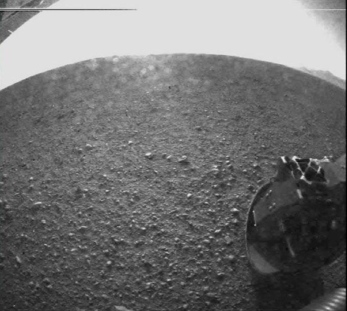
Posted by: Carson O'Genic Aug 6 2012, 08:54 AM
That ground looks very solid. The wheel din't seem to make a dent.
Posted by: James Sorenson Aug 6 2012, 08:58 AM
Wow that was an excellent EDL, Congrats to NASA and the whole MSL team for a job well done. Here is my first contribution to the MSL mission.
Pospa's image in an un-distorted fashion!

|
Posted by: Stu Aug 6 2012, 08:59 AM
Oh boy... sounds like MRO got the pic of Curiosity on the way down...!!
|
|

Posted by: MERovingian Aug 6 2012, 09:02 AM
At last the way is clear and I can finaly get through to UMSF to say congrats to Rob Manning, to the EDL team, to all of JPL, to Nasa for all this amazing work; you should be so proud!! You did it again!
8 years ago I followed the MER landings from Canada, and this morning I witnessed Curiosity getting on the Martian soil from my old house in France; thrice, plenty of Mars bars to celebrate, my liver about to explode every time!
Again, bravo, bravo, bravo for this new tour de force!
You are amazing!
Go Curiosity!
Posted by: pospa Aug 6 2012, 09:02 AM
... And those "hills" on the right horizon are Gale crater rim? I would say so.
Its from right rear hazcam, sun almost in the middle of the picture, its 3-4 pm local -> that picture is towards NW, right.
So Mt Sharp should be visible from left front hazcam - SE view.
Posted by: MERovingian Aug 6 2012, 09:04 AM
|
|
OMG!!! Where is the picture, where is the picture??!!
The one of Phoenix from MRO was breathtaking!!

Posted by: Gladstoner Aug 6 2012, 09:06 AM
.
Posted by: elakdawalla Aug 6 2012, 09:13 AM
Those HiRISErs are such teases! We won't see the image til the 9:00 press briefing.
Posted by: jamescanvin Aug 6 2012, 09:18 AM
Yes, the rim is lost in the glare in that pic, here is a stretch of the one from the raw site. Useless for the foreground but does show more of the rim. Looks to me like a small topographic rise on the near horizon is obscuring the bit on the left.

|
Posted by: MERovingian Aug 6 2012, 09:26 AM
9:00 am or pm?? EDT or Pacific??
My God, it's gonna be at the earliest 15 pm here in France!!
Hurry up Hirisers!! I'm an old man!!
Posted by: punkboi Aug 6 2012, 09:34 AM
Don't forget about Phoenix in 2008. It's not a rover, but you know...
Anyways, congrats to JPL and the MSL team for another awesome achievement for space exploration! Looking forward to seeing Curiosity's wheels finally begin motion on the surface of Gale Crater...
Posted by: Skyrunner Aug 6 2012, 09:34 AM
9am PDT -> 18hrs in France
We'll be eating with a plate on our lap in front of the tv/laptop
Posted by: ustrax Aug 6 2012, 09:35 AM
Confirmed: Image on the ground, being processed, released at the 9am (Pacific) press conference.
Posted by: jamescanvin Aug 6 2012, 09:45 AM
In fact, thinking about this some more, if the reported coordinates are close, that 'small' rise that obscures the crater rim on the left of the RHaz is possibly the edge of the mountain, something like:

|
Posted by: gndonald Aug 6 2012, 10:17 AM
I'm coming into this a bit late, but full congratulations to NASA, they took a big risk and it paid off. I'm hoping the first color pictures don't take too long.
Posted by: jamescanvin Aug 6 2012, 10:27 AM
Combining the http://photojournal.jpl.nasa.gov/catalog/PIA15973 of the Rear Hazcam that has been stretched well for the foreground, with a stretch of the http://mars.jpl.nasa.gov/msl/multimedia/raw/?rawid=RLA_397506144EDR_D0010008AUT_04096M_ for the sky to show the rim of Gale better.

|
Posted by: Tesheiner Aug 6 2012, 10:35 AM
Here're two snapshots from Google Earth, facing east and west.

|

|
Posted by: OWW Aug 6 2012, 11:05 AM
Dark gravel, no rocks, local rise close to the horizon.... Could it have landed on top of the dune-field?
Posted by: NMRguy Aug 6 2012, 11:33 AM
Three cheers for NASA engineers! Now let the science begin.
Posted by: jmknapp Aug 6 2012, 11:36 AM
Looks like, assuming the coordinates hold up. One thing though--it'd be on the far outskirts of the much-discussed alluvial fan:

|
So would they backtrack into the fan, or cancel that & head for the hills? Also, would they want to cross that dark dune field directly, or would they do an end run? Looking at some of the published literature on the site, I think these are called mafic dunes, comprised of dark volcanic material blown in from elsewhere.
Posted by: imipak Aug 6 2012, 11:42 AM
That surface doesn't look like a dune to me, and the wheel's clearly resting solidly on the surface. There's also no sign of dune-like topology and the vehicle's only four degrees off perfectly level. For these reasons I don't think we're in, or on, dunes.
Posted by: jamescanvin Aug 6 2012, 11:48 AM
A reprojected version of my RHaz image as requested by Emily on Twitter.

|
Posted by: tedstryk Aug 6 2012, 11:51 AM
Congratulations to everyone involved with MSL!
Posted by: vikingmars Aug 6 2012, 11:55 AM
Just coming back from our MSL event near Paris. 347 people gathering at 05:00 am (French ECT time) + 1 MSL/ChemCam scientist with us + 3 Nationwide TVs + 4 nationwide radios + 4 people from JPL on the phone after touchdown to give us their 1st impressions.... Wow ! what a BIG show NASA and JPL gave us. The live "tones" were perfect during the descent and we were able to translate them -live- into French !
Congrats to Rob Manning and his team of great engineers : they won the GOLD medal of the "Marslympics Games" by nailing their probe (i) on target (ii) on schedule and (iii) with its remaining in very good shape !
Although we were quite confident (so many tests done), we are still very impressed by :
- this great NASA technological achievement ;
- the great professionalism of JPL's engineers and their quest for excellence in doing their jobs ;
- ...and (most important of all) their great human qualities that give the true meaning for this remote exploration of the Red Planet.
(yes now they are 6 more wheels on Mars)
Posted by: Julius Aug 6 2012, 11:57 AM
Well done NASA ! technology at its best!
Posted by: craigmcg Aug 6 2012, 12:29 PM
Wow, such great support.
Posted by: Astro0 Aug 6 2012, 12:33 PM
Fascinating screengrab from Parkes Radio Telescope posted on Twitter.
(Parkes was being used to capture UHF during EDL for later forensics).

|
"Parkes 64m @ UHF (401MHz) as backup for @canberradsn. Attached plot shows doppler signal, wiggles are MSL on parachute!"
Posted by: gpurcell Aug 6 2012, 12:43 PM
I'm very happy at the first look at the ground; whatever else Gale is like, it isn't like Gusev!
Posted by: djellison Aug 6 2012, 01:14 PM
No - firstly, the ground is clearly has pebbels on it. Secondly - the FHZ image, small though it is - shows the dune field a dark linear feature to our east.
Posted by: jmknapp Aug 6 2012, 01:21 PM
Eyes on the Solar System shows a different landing site from the coordinates read off last night--does that reflect post-landing information?
The red dot below shows the Eyes location, the blue dot the verbal coordinates last night (modulo the accuracy of the Google Earth model):

|
Posted by: craigmcg Aug 6 2012, 01:28 PM
My wish list for the briefing in less than 3 hours:
- MRO photo (or photos?)
- Update on high-gain antenna deployment
- An update on the progress through the self-check timeline
- Mardi photo sequence (don't know when this is expected to be ready)
- Some discussion about the apparent dust on the hazcam lenses
Posted by: Drkskywxlt Aug 6 2012, 01:33 PM
I'm eager to hear whether they decide to examine the alluvial fan or go straight for Mt. Sharp since they seem to be right on the edge of the fan now.
Posted by: djellison Aug 6 2012, 01:34 PM
I'm afraid you're getting ahead of the game, Craig.
There hasn't been another UHF pass with the vehicle since that second ODY pass - so expect nothing new from the surface. I think social media is fairly in-tune with the HiRISE team and that they do indeed have something special to show us.
It not even midnight of Sol 0 yet - no HGA deployment details. No MARDI yet (we will get a few thumbnails later today - it will take weeks to get the full image sequence)
There has certainly been some fascinating discussion about what we can see in those early Hazcam images - hopefully some analysis of that as well.
Posted by: ugordan Aug 6 2012, 01:39 PM
I forget, when is the next (MRO?) data relay scheduled?
Posted by: Stu Aug 6 2012, 01:41 PM
Is this what we're seeing, do you think..?

|
(gif animation, click to start)
Posted by: nprev Aug 6 2012, 01:42 PM
Spaceflight Now reporting that a descent image was indeed captured by MRO.
Posted by: djellison Aug 6 2012, 01:45 PM
Personally - I agree with you We must be facing east given the shadow, and Sharp should indeed be visible to our east. A nominal touchdown toward the center of the ellipse would put the dunes in view also.
Posted by: ynyralmaen Aug 6 2012, 01:48 PM
What a fantastic day - many congratulations to all involved! Really impressive and inspiring stuff...
Is there an official (or semi-official) touchdown time? How much did it differ from the pre-landing estimate? I know it's a pretty minor matter in the big scale of things; hope I'm not being too much of an anorak!
Posted by: craigmcg Aug 6 2012, 01:48 PM
How much (if any) sleep is everyone running on about now Doug
Posted by: djellison Aug 6 2012, 01:50 PM
Well - Eyes on the Solar System was off by half a dozen seconds we think - and it was running OD142, a several week old predict.
Currently running on about 3 hours of sleep. Back to the office for the 9am press conf
Posted by: nprev Aug 6 2012, 01:50 PM
You're asking the wrong guy, Craig. The Chairman of UMSF never sleeps...he merely waits. 
Posted by: craigmcg Aug 6 2012, 01:57 PM
I think I have a peanut hangover.
Posted by: stewjack Aug 6 2012, 02:22 PM
Was the sun setting at landing? I guess I was completely turned around, I thought the sun was rising and the hazcam was facing west.
Posted by: Nix Aug 6 2012, 02:24 PM
spare us the details on that hangover and we'll be fine
In this stage, I'm looking forward most of all to the descent images.
Posted by: jmknapp Aug 6 2012, 02:27 PM
The sun was at azimuth 252° (18° south of due west), elevation 34°.
Midnight LTST was at 13:55 UT today, marking the start of sol 1. Sunrise is at 20:10 UT.
Posted by: ugordan Aug 6 2012, 02:27 PM
3-4 PM-ish local time, IIRC.
Posted by: Marslauncher Aug 6 2012, 02:32 PM
Monday, Aug. 6
12:30 to 1:30 a.m. Landing Commentary No. 2
9 a.m. Landing Recap News Briefing
4 p.m. Possible New Images News Briefing
Tuesday, Aug. 7
10 a.m. News Briefing
Wednesday, Aug. 8
10 a.m. News Briefing
Thursday, Aug. 9
10 a.m. News Briefing
Friday, Aug. 10
10 a.m. (tentative) News Briefing
All times are PDT I believe. (information fromhttp://mars.jpl.nasa.gov/msl/news/whatsnew/index.cfm?FuseAction=ShowNews&NewsID=1273)
Posted by: blobrana Aug 6 2012, 02:33 PM
Good work on the the coordinates.

|
Posted by: jamescanvin Aug 6 2012, 02:38 PM
Yes setting, sunset was just a couple of hours after landing and it is just after midnight now (starting sol 1)
Posted by: hendric Aug 6 2012, 02:45 PM
Congrats Rob & team on a picture-perfect landing! You can fly me anywhere.
Posted by: SteveM Aug 6 2012, 02:48 PM
Just saw this in the Guardian:
Posted by: eoincampbell Aug 6 2012, 02:58 PM
Congrats to all involved, what a night ! Go Curiosity !
Posted by: AdamH Aug 6 2012, 03:27 PM
Indeed, congrats to the MSL team. Was up till 3am watching and thinking, "I'm going to up my game... but maybe tomorrow after I get some sleep." Great work with Eyes, Doug. Having it open next to NASA TV on my display really ratcheted up the tension.
Can't wait to watch Aeolis Mons revealing itself over the next months and years.
Posted by: stewjack Aug 6 2012, 03:31 PM
About half hour to next briefing
16:00 UTC
Mars Science Laboratory/Curiosity Rover Post-Landing News Briefing - Landing Recap and Sol 1 Outlook
http://www.nasa.gov/multimedia/nasatv/ustream.html
Posted by: Art Martin Aug 6 2012, 03:34 PM
I watched coverage last night on my computer on Ustream - Curiosity Cam. This morning I'm at work and only able to view or hear things through my Droid phone not on my work computer. Does anyone know if the news conference this morning will be available through that same channel or is there a better way of getting it through my phone? Amazing job to all the team members by the way.
Posted by: jmknapp Aug 6 2012, 03:44 PM
Here's a little almanac for the next day or so, showing MRO & ODY passes (maximum altitude given, all times Pacific):
5AUG 22:17 MSL touchdown
5AUG 22:18 MRO 57°
5AUG 22:20 ODY 20°
6AUG 0:18 ODY 40°
6AUG 0:41 sunset
6AUG 4:47 MRO 75°
6AUG 6:55 midnight local solar time (start of sol 1)
6AUG 11:03 ODY 40°
6AUG 12:03 ODY 5°
6AUG 12:10 sunrise
6AUG 22:53 MRO 44°
7AUG 0:00 ODY 64°
7AUG 1:21 sunset
7AUG 7:36 midnight LTST, sol 2
7AUG 10:48 MRO 34°
7AUG 12:50 ODY 23°
7AUG 13:50 sunrise
Will the night passes be used?
Posted by: Big Joe Aug 6 2012, 03:55 PM
WOW!
Curiosity from the MRO
Just posted here http://www.planetary.org/blogs/emily-lakdawalla/2012/08060824-hirise-curiosity-parachute.html
Posted by: Hungry4info Aug 6 2012, 03:55 PM
As tweeted

|

|
Posted by: nprev Aug 6 2012, 03:57 PM
Legit now, yes.
Stunning. No words.
EDIT: Press conference starting.
Posted by: stewjack Aug 6 2012, 04:02 PM
http://www.nasa.gov/multimedia/nasatv/index.html
Mobil streams iOS Andriod
Posted by: Hungry4info Aug 6 2012, 04:03 PM
Press conference starting.
Posted by: craigmcg Aug 6 2012, 04:05 PM
Some tired and happy looking people at the PC.
Posted by: CryptoEngineer Aug 6 2012, 04:09 PM
Sadly, the JPL site is oversubscribed; I can't get on from either my PC or my phone.
If anything new and noteworthy is said, I hope it will be relayed here.
CE
Update: The NASA site
http://www.nasa.gov/multimedia/nasatv/index.html
works fine.
CE
Posted by: Bernard Aug 6 2012, 04:12 PM
Curiosity by MRO is absolutely incredible.
Congratulations to anyone involved in this wonderfull succes
Posted by: lyford Aug 6 2012, 04:13 PM
try
ustream.tv/NASAJPL
it's working for me
Posted by: Drkskywxlt Aug 6 2012, 04:13 PM
Wow...only 2 km east and a few hundred meters north of the center of the ellipse. I'd call that a bullseye.
Posted by: craigmcg Aug 6 2012, 04:14 PM
For those who can't get on to NASA TV, some notes:
- rover is in nominal state (not safe mode)
- will get more pics back later today
- roughly flat (-3 deg down, 2 deg to the side)
Sharing landing info now.
Posted by: Tesheiner Aug 6 2012, 04:14 PM
A slide with JPLs estimate of the landing point.

|
Posted by: dvandorn Aug 6 2012, 04:16 PM
That looks to be very close to the co-ordinates that were called out at the end of EDL last night and were mapped here at that time. Very close indeed.
-the other Doug
Posted by: lyford Aug 6 2012, 04:16 PM
"Speaking of HIRISE.... "
Posted by: craigmcg Aug 6 2012, 04:16 PM
Talking about MRO now.
Posted by: Tesheiner Aug 6 2012, 04:19 PM
-the other Doug
So close that I'm still in doubt if this is a refined position or not.
Posted by: lyford Aug 6 2012, 04:19 PM
"MRO has taken over 120 images of Gale, but I think this is the greatest one..."
Posted by: Nix Aug 6 2012, 04:19 PM
Holy **** !!!!! that parachute picture is a joke to my best fantasy - it's surreal!! The depth with the canyon underneath, the angle captured.... I've been dreaming of an MRO pic like this !
Thankyou Hirise !
Posted by: Hungry4info Aug 6 2012, 04:24 PM
Confirmation of the identification of Mt Sharp.
Posted by: Drkskywxlt Aug 6 2012, 04:24 PM
Good call to whomever posted the front hazcam with the dune field and Mt. Sharp outlined...John Grotzinger agrees!
Posted by: craigmcg Aug 6 2012, 04:25 PM
Confirming early read of dark dune field and bright mt. sharp that we saw pointed out here early this morning.
Posted by: craigmcg Aug 6 2012, 04:27 PM
about 10 k to base of mt sharp via planned route
Posted by: Hungry4info Aug 6 2012, 04:29 PM
Skycrane was instructed to fly north. So I doubt there was any chance of imaging it in the RHazcam images.
Edit: Was asked about during the press conference. Science team saw it, thought about it, might be dust devil, too early to tell what it is.
Posted by: craigmcg Aug 6 2012, 04:31 PM
MRO - Good pictures of landing site expected to be taken in about 6 days and again in 12 days. "hazy" picture to be taken in one day.
Posted by: gallen_53 Aug 6 2012, 04:32 PM
A similar picture by MRO was done for Mars Phoenix. Al Witkowski of Zodiac Aerospace (Pioneer Aerospace) was the main guy behind the Disk Gap Band (DGB) parachute used by MSL. The MSL's parachute deployed at close to Mach=2 which was simply ridiculous. The technology behind this parachute design was prototyped in the early 1970s for the Viking Mars lander. Wind tunnel tests at MSL's peak dynamic pressure (but not Mach number) were done at NASA Ames wind tunnels. Al Witkowski and Pioneer Aerospace are the world's best in parachutes.
Posted by: Nix Aug 6 2012, 04:37 PM
I know the Phoenix picture but this one impresses me more in close-up.
Posted by: kenny Aug 6 2012, 04:40 PM
Just picking this up on a shaky connection in Kabul ... congratulations to all concerned on a magnificent achievement. We laughed incredulously when we first saw this technique being proposed some years ago. What an extraordinary vindication of some astonishing engineering.
Posted by: bgarlick Aug 6 2012, 04:49 PM
It was mentioned in the conference that the MAHLI instrument will take a color picture out the side since it can focus at infinity. Stupid question: Does the instrument while stowed (the position I presume it will be in when the picture is taken) look to port (Gale crater rim) or to starboard (mt sharp)?
Posted by: craigmcg Aug 6 2012, 04:50 PM
The tone in this conference is much different than yesterday's. Yesterday, all the discussion seemed to be about the difficulty of landing, lots of hand-wringing. Today, much more matter-of-fact.
Posted by: RoverDriver Aug 6 2012, 04:55 PM
If I have my heading correctly it would be Gale rim (North-ish)
Paolo
Posted by: Juramike Aug 6 2012, 04:56 PM
Picking up from the press conference that Curiosity might be sitting on the alluvial fan! (cohesive materials, firm under the wheels, fairly uniform grain size).
(So we just landed on Eberswalde too! Score!!)
Posted by: RoverDriver Aug 6 2012, 04:56 PM
This 'chute is also bigger, more pixels!
Paolo
Posted by: RoverDriver Aug 6 2012, 04:58 PM
I *think* she meant CTX and was trying to find a more understandable way of expressing it.
Paolo
(So we just landed on Eberswalde too! Score!!)
It is too early to tell exactly where we are. I'm working on it.
Paolo
Posted by: Greenish Aug 6 2012, 05:00 PM
Paolo
They just said the (vehicle?) azimuth is 112 degrees, first I heard a number other than SE. They hadn't sorted it out specifically yet but thought the MAHLI would point towards roughly "flank" of mountain and/or crater rim.
Posted by: RoverDriver Aug 6 2012, 05:03 PM
When the MSL Arm is stowed the MAHLI camera points roughly to the left side. If we are at 122deg the MAHLI camera would point to roughly 22 deg (not sure if MAHLI is 90 deg to the rover left, but close enough).
Paolo
Posted by: Pando Aug 6 2012, 05:07 PM
Enhanced parachute image:

|
Posted by: pgrindrod Aug 6 2012, 05:09 PM
A quick look, but I think you can see the backdrop to that (absolutely gobsmacking) HiRISE shot of Curiosity in http://hirise.lpl.arizona.edu/ESP_023957_1755. It's about half way up on the left-hand side.
And of course that's one of a stereo pair, so you can use the HiRISE PDS DEMs too.
So with 10 m contours over very roughly the same area (with different viewing geometry of course):

|
And with a colour scale, stretched for the topograhpy just in this image (it looks worse than it is!):

|
The red line is actually the edge of my best guess of the revised landing ellipse.
What a day this has been!
Pete
Posted by: gallen_53 Aug 6 2012, 05:17 PM
It's amazing that JPL could tweek MRO's orbit such that it could take parachute pictures for Phoenix and MSL. This was very hard to do (think about the timing required). We see these picture and are briefly entertained but doing the orbital mechanics must have kept some extremely skilled guys busy for days. There was a huge amount of devil in the detail.
Posted by: nprev Aug 6 2012, 05:18 PM
Press conference over.
Landing speeds: 0.75m/sec vertical, 0.04m/sec horizontal.
That's about as gently as you put a baby in a crib.
Wow.
I am so proud of the MSL team.
Posted by: kenny Aug 6 2012, 05:26 PM
I certainly hope you don't put your baby to bed at 0.75 metres per second.... :-)
Posted by: jmknapp Aug 6 2012, 05:26 PM
Edit: Was asked about during the press conference. Science team saw it, thought about it, might be dust devil, too early to tell what it is.
They acknowledged it could be the descent stage too.
Later in the questions, the chief engineer of guidance and control, Miguel San Martin, said that they only tell the descent stage to favor the northward direction, but they're restricted in that since they have to tilt the stage first, they can only tilt it on orthogonal axes--two choices--to not cause a spin. So, depending on the orientation the direction will be toward the northernmost quadrant at the time, not necessarily due north.
Posted by: fredk Aug 6 2012, 05:27 PM
Nice job locating the backdrop, Pete!
Here's an animation showing MSL's shadow growing as the sun sets on sol 0:

|
(Both frames of the animation are L/R averages.) The potential central mound slope is visible in the second frame as well, in fact maybe with better contrast as the antisolar brightening area rises. Absolutely can't wait for more pics.
You know something big's going on when people try to squeeze this much out of thumbnails that are about to be made obsolete after the next odyssey pass in about an hour!
Posted by: fredk Aug 6 2012, 05:39 PM
Anyway, I'm sticking to my claim that the smudge is from the DS impact. It doesn't especially look like a DD, and the timing is really really suspicious. Of course they're just throwing out all their ideas. They pointed out that the azimuth of the DS could be anywhere from -90 to +90, and the smudge is very roughly -80 by my estimation.
Posted by: nasaman58 Aug 6 2012, 05:45 PM
Those are, in fact, dunes lining the base of the mountain ("Mt. Sharp."). I imagine the rover will not try to traverse those due to becoming trapped.
Posted by: Bjorn Jonsson Aug 6 2012, 05:55 PM
Here is some extremely preliminary and quick and dirty stuff:
|
|
These are very crude 3D renders that assume the landing position shown at the press conference. At the moment the DEM is MOLA-only so no small scale features are visible but big stuff like the crater rim and Mt. Sharp are easily resolved. The mountain is obvious in the SE direction.
Now I need to dig up a higher resolution DEM and integrate it into the MOLA stuff to get much better renders. I also need to figure out why rendering the DEM in the W/SW/S directions didn't work - that's the reason these directions are 'missing'.
So far I have mainly been processing outer solar system data but modifying my stereo software to generate depth maps instead of global scale DEMs of Saturn's satellites is seriously tempting but probably a lot of work. It would also require extremely accurate information on the viewing geometry of any images used as stereo pairs.
EDIT: Each render has a field of view of 45 degrees.
Posted by: Silmfeanor Aug 6 2012, 06:01 PM
A very interesting post on Nasaspaceflight.com from the engineer who worked on the dust covers:
http://forum.nasaspaceflight.com/index.php?topic=29612.msg938852#msg938852
Posted by: Art Martin Aug 6 2012, 06:07 PM
I would think, given the huge wheels this rover has, that getting stuck in dunes is going to be much less of a concern than it was with Spirit and Opportunity. I'm curious if the rover drivers would even care now if they encountered small and moderate dunes in the path. I'd love to know what testing has taken place.
Posted by: lyford Aug 6 2012, 06:17 PM
See:
NASA engineers take the Curiosity test rover to California's Mojave desert to learn how to drive on Martian sand dunes.
http://www.youtube.com/watch?v=AVqsV4rQ4bE
Posted by: Marslauncher Aug 6 2012, 06:18 PM
Looking at the Eyes on the Solar System currently it appears as if Odyssey is about to make an overpass wonder how quickly pictures will downlink
Posted by: Fred B Aug 6 2012, 06:27 PM
I find it interesting that this is yet another case where the actual landing site was downrange of the target. MPF, 2 x MERs, Phoenix, and now MSL too:
http://www.lpi.usra.edu/meetings/modeling2008/pdf/9103.pdf
Posted by: hendric Aug 6 2012, 06:31 PM
Can someone point me to a schedule of operations for the next few days? I know there was a slide during one of the conference calls that listed events for the next week or two, but I can't find it on the NASA or JPL sites. Thanks a bunch!
Posted by: MoreInput Aug 6 2012, 06:42 PM
And from me congrats to the MSL team for this landing. I think the next 98 weeks will be really cool. And thanks to the MRO team for this stunnig parachute pic!
And I think the last eight years with Spirit and Oppy were for the grandios UMSF guys just a training phase for the photos which will come from MSL!
Posted by: MahFL Aug 6 2012, 06:51 PM
All wheeled vehicles can get stuck in sand. The trick now is to recognize potential traps, and to set "wheel slip" limits to avoid digging in the wheels, which I assume they did not with Oppy when she go stuck in pergutary.
Posted by: Explorer1 Aug 6 2012, 06:53 PM
I'm pretty sure the cruise stage burned up in the atmosphere, correct me if I'm wrong?
Posted by: MahFL Aug 6 2012, 06:55 PM
I believe they actually targeted the spot they landed in. I do not think they aimed for the middle of the ellipse. The closer they are to Sharp the quicker they can get to that science.
Posted by: MahFL Aug 6 2012, 06:58 PM
I think most of it did, I believe a few denser parts of it may have survived, but not much.
Posted by: MahFL Aug 6 2012, 07:01 PM
I noted at the news conference the EDL guy said they had help from Langley, using assets he best not talk about, the DOD pretty much knows exactly where Curiosity is
Posted by: Marslauncher Aug 6 2012, 07:01 PM
Some new pictures have come down and are on http://mars.jpl.nasa.gov/msl/multimedia/raw/
http://mars.jpl.nasa.gov/msl/multimedia/raw/?rawid=FLA_397506068EDR_D0010008AUT_04096M_&s=0
Posted by: fredk Aug 6 2012, 07:03 PM
http://mars.jpl.nasa.gov/msl-raw-images/proj/msl/redops/ods/surface/sol/00000/opgs/edr/fcam/FRA_397506083EDR_F0010008AUT_04096M_.JPG
Posted by: Explorer1 Aug 6 2012, 07:06 PM
Yes, the 'guilt' cartoon in the humor thread was a bit off like I thought.
I'm trying to imagine what the heat shield looks like now; it left a bigger hole than Oppy's for sure. I wonder if it turned inside out too.
And hello Mt. Sharp; glad to have a clear view of you!
Posted by: Drkskywxlt Aug 6 2012, 07:07 PM
Great detail on those new front hazcams. Can see some texture at the base of Mt. Sharp beyond the dunes.
Posted by: Tesheiner Aug 6 2012, 07:07 PM
Me ... want ... mosaic!
http://mars.jpl.nasa.gov/msl-raw-images/proj/msl/redops/ods/surface/sol/00000/opgs/edr/fcam/FRA_397506083EDR_F0010008AUT_04096M_.JPG

Posted by: ElkGroveDan Aug 6 2012, 07:08 PM
Levels adjusted a bit

|
Posted by: ugordan Aug 6 2012, 07:09 PM
Mt. Sharp!

|
Posted by: nprev Aug 6 2012, 07:13 PM
...Um.
Think we're gonna like it here.
Posted by: Bjorn Jonsson Aug 6 2012, 07:15 PM
Apparently the most photogenic landing site on Mars so far.
Posted by: ugordan Aug 6 2012, 07:16 PM
Can someone linearize one of these? I'm eager to see how that scenery actually looks like.
Also, I guess this is a good sign that we'll be seeing some MARDI thumbnails in a few hours as well.
Posted by: OWW Aug 6 2012, 07:17 PM
Beautiful! But that black rock looks suspiciously like basalt.
Posted by: Pando Aug 6 2012, 07:20 PM
It's interesting to see some pebbles already present inside the wheel. This could mean that the skycrane dragged the rover a bit before cutaway.
Posted by: MahFL Aug 6 2012, 07:21 PM
I note the wheels are turned in, does anyone know if this was the planned position of the front wheels at landing ?
Posted by: dot.dk Aug 6 2012, 07:22 PM
What a way to spend the morning!
Unbelievable, unreal
What a magnificent achivement!
Question: Not much of the front wheels are visible in the hazcams. I would imagine when they straighten up the would be even less visible. Wouldn't that be a problem if the get rocks stuck in them or if the do somehow get stuck in sand? They could probably do some imaging with MAHLI, but that would be more complicated. I'm sure they designed it the best way possible, just curious what thought this has been given?
P.S. Time for some new emoticons to supplement and  ?
?
Posted by: jmknapp Aug 6 2012, 07:24 PM
In earth gravity, something dropped from a height of about an inch will have a velocity of 0.75 m/sec at impact. I'd say the little tyke could take it.
Posted by: MERovingian Aug 6 2012, 07:26 PM
Amazing, amazing, amazing....
I believe I must have said that word a thousand times today... I'd better keep on working on my english to put better words on all the good things that Curiosity is about to uncover for us in the coming years.
That first look at Mount Sharp though, it's.. ah well, you know.
Posted by: gallen_53 Aug 6 2012, 07:26 PM
MSL jettisoned a significant amount of tungsten ballast. The total mass of that ballast was greater than the mass of the MER rover. Most of the ballast would have impacted on the Martian surface.
Posted by: Drkskywxlt Aug 6 2012, 07:27 PM
What black rock? The dunes? How can you tell something's basalt from a coarse-resolution b/w image?
Posted by: MahFL Aug 6 2012, 07:28 PM
I was referring to the cruise stage.
Posted by: jamescanvin Aug 6 2012, 07:28 PM
Yes, watch the landing animation again.
Posted by: OWW Aug 6 2012, 07:29 PM
No, not the dunes. That small triangular black rock just above the shadow of the rover.
Posted by: dvandorn Aug 6 2012, 07:31 PM
Interesting -- Google Chrome doesn't display this page properly. Ever since the wee hours when I first pulled this page up, in Chrome all I get are image placeholders and clicking on any of the placeholders just re-displays the same page with the placeholders.
Works just fine, as designed, when I access the site via Internet Explorer 9.
Just an FYI for y'all.
-the other Doug
Posted by: ugordan Aug 6 2012, 07:31 PM
Heh, you just made me realize the "7 minutes of terror" video straightens up the front wheels shortly after the rover is lowered on the bridle.
Posted by: Pando Aug 6 2012, 07:32 PM
When MER rovers landed, they were absolutely pristine--brand new machines with gleaming surfaces from another world, waiting for commands from their masters...
MSL on the other hand already looks like it's been on Mars for a while. It's got dusty lenses and dirty wheels with pebbles rolling around inside.
Posted by: OWW Aug 6 2012, 07:34 PM
Firefox is the same. IE9 is fine though.
Posted by: Drkskywxlt Aug 6 2012, 07:34 PM
Still not sure how it could be classified based on that image. Shadows are long in that image, that could be a shadow from a smaller rock nearer the rover.
Posted by: MahFL Aug 6 2012, 07:35 PM
Do you have a url for that, I watched several and they all had the wheels pointing straight ahead, thanks.
Posted by: volcanopele Aug 6 2012, 07:35 PM
Trying to compare the dunes we see in the distance to Tesheiner slope maps in Google EarthMars. Looks like there is a gap in HiRISEwhere I think the more interesting details in the dunes visible in the Fcam are located. Not sure if that is a real gap (truly no HiRISE data) or if Tesheiner just didn't include that image.
Posted by: Tesheiner Aug 6 2012, 07:35 PM
Works just fine, as designed, when I access the site via Internet Explorer 9.
Just an FYI for y'all.
-the other Doug
It happened to me early on but the problem disappeared by reloading (F5) the page. Cleaning the cache might solve it too.
Posted by: MahFL Aug 6 2012, 07:36 PM
MER's were inside airbags, MSL was under a jet plume.
Posted by: AdamH Aug 6 2012, 07:37 PM
|
If I'm interpreting that correctly, the filled channel they're considering as a primary traverse route should be just to the right of that downslope on the right side of the image. The "fence" that's beyond the dune field might be just off to the right in the distance. Anyway, those features at the bottom of the slope are going to get a *whole* lot bigger. I've dropped a 50m tall marker in the channel in the image below. The fence itself is a good 50m or so tall.
http://www.flickr.com/photos/midnightzulu/7727565414/in/photostream
Posted by: Tesheiner Aug 6 2012, 07:40 PM
The mosaic was assembled by jmknapp (I just ported it to GE) and I'm trying to remember the discussion between him and Paolo about that gap.
Posted by: nprev Aug 6 2012, 07:42 PM
MSL on the other hand already looks like it's been on Mars for a while. It's got dusty lenses and dirty wheels with pebbles rolling around inside.
You have to remember that the MERs (and MPF) were basically encapsulated upon landing; they didn't get 'unpacked' until the bouncing was done, the airbags were retracted, and the petals opened up.
This was a powered descent with very robust thrusters. MSL's big, so it had to be done that way. Not too surprising that some debris was kicked up thereby.
Posted by: algorimancer Aug 6 2012, 07:42 PM
There's a bit of topography visible in the stereo views.
Cross-eyed pair:

|
Anaglyph (hopefully I haven't swapped L/R in this one):

|
stphmkre recommended.
Posted by: jamescanvin Aug 6 2012, 07:46 PM
Ha, Ok maybe I was the one who needed to rewatch it. I remembered that they were towed in after deploy but hadn't noticed that they were straight at landing, I always assumed they would stay pointed in as straightening would be an extra unneeded complication.
Posted by: ugordan Aug 6 2012, 07:48 PM
Could still be an inaccuracy in that video.
Posted by: Mongo Aug 6 2012, 07:51 PM
It looks to me like Curiosity landed on the edge of the alluvial fan. The firm surface with well-sorted pebbles suggests this, and on the hazcam images you can see that the terrain that Curiosity is currently sitting on, comes to an end well short of the dune field, with a lighter-coloured unit between them.
Posted by: MahFL Aug 6 2012, 07:51 PM
The less parts moved around during EDl would be sensible.
Posted by: fredk Aug 6 2012, 07:51 PM
You do seem to have L/R swapped, alg.
Here's my attempt (with a bit of de-headaching applied):

|
Posted by: Fran Ontanaya Aug 6 2012, 07:59 PM
White balanced Mount Sharp cross eye:

|
Posted by: MahFL Aug 6 2012, 08:00 PM
It's going to be like driving to the Columbia Hills again, but many times better .
Posted by: tbruckner Aug 6 2012, 08:12 PM
What's the reason why sofar all of the data reveived has been from Odyssey. Shouldn't MRO be able to dump much more data than Odyssey?
Posted by: Marslauncher Aug 6 2012, 08:19 PM
Watching Eyes on the Solar System again, It appears we are about to watch sunrise at Gale Crater. Also looks like we may have just had another Odyssey overflight.
Posted by: jmknapp Aug 6 2012, 08:21 PM
I'm pretty sure the mosaic includes all the DTMs that are currently publicly available. Paolo mentioned another one, 24102, that I think he has access to & will be on the HiRISE site "soon." There's another small gap even so, which is what volcanopele is referring to I think.
I'd like to know what the schedule is for completing DTMs all the way up Mount Sharp--I assume that's a priority at least for an extended mission. Maybe what they already have is good for a year or more.

|
Posted by: nprev Aug 6 2012, 08:22 PM
Well, let me take a crack at that (and someone more knowledgable please feel free to correct me):
1. Odyssey is the oldest orbiter at Mars currently, and therefore using her as a primary comm relay is a very good utilization of the limited resources available.
2. MRO is the latest & greatest, and therefore its payload capabilities are in the greatest demand from the scientific community. Comm relay for surface assets is secondary at this point.
3. All current orbiters at Mars (MODY, MRO, and Mars Express) are equipped with the "Elektra" UHF ground-to-surface system. A standard protocol like this generally limits the available bandwidth in that link of the chain (and it has to be standardized to cope with whatever surface missions may come from whomever also similarly equipped). Therefore, this is the limiting factor in data relay capability; not the intrisic capabilities of the orbiters DTE.
Hope I got that right. If not, again please correct me; I'll learn something!!!
Posted by: ChrisC Aug 6 2012, 08:22 PM
http://forum.nasaspaceflight.com/index.php?topic=29612.msg938852#msg938852
Amid all the new-image excitement, I wanted to make sure this didn't get missed. It's a really good narrative on the design of the "now-world-famous dust covers", by the engineer who did it.
See link above for his first post, and then this one for a short followup:
http://forum.nasaspaceflight.com/index.php?topic=29612.msg938902#msg938902
Posted by: tbruckner Aug 6 2012, 08:29 PM
That seems odd to me, MSL is a much bigger mission than MRO, surly getting the MARDI data down ASAP would be more important than another hires image? Especially with MRO having a much bigger bandwidth down to earth?
Posted by: um3k Aug 6 2012, 08:34 PM
Someone requested linearized images? Here you go, cross-eyed 3d to boot.
https://picasaweb.google.com/lh/photo/D50iI2efOCU_WqQ14yxaUtMTjNZETYmyPJy0liipFm0?feat=directlink
Posted by: Deimos Aug 6 2012, 08:37 PM
I kinda think every quality overpass so far has been used. ODY got one extra due to orbital positioning. And MRO grabbed many times more data than ODY during EDL. I think there may have been a few MRO-->Earth windows needed for that. Over time, ODY may get used more, I don't know. But in the span of a couple days, it frequently comes down to how good the overflight is.
Posted by: nprev Aug 6 2012, 08:41 PM
Gotta remember that these are two independent missions with their own science teams & their own objectives tailored to the capabilities of their platforms. MRO's primary mission is not to serve as a comm relay for surface missions, but instead to accomplish detailed global reconnaissance of Mars.
Posted by: kwan3217 Aug 6 2012, 08:43 PM
From the numbers read off last night (I replayed the recording this morning and jotted them down) the landing time seemed off. They said 10:14:39 (pm PDT) which translates to 05:14:39 UTC. However, once you add 13m48s of light time, that gives an ERT of x:28:27. Did they really land three minutes ahead of schedule? I don't recall entry being that much earlier.
Posted by: Gladstoner Aug 6 2012, 08:50 PM
.
Posted by: Gladstoner Aug 6 2012, 08:53 PM
.
Posted by: jamescanvin Aug 6 2012, 08:55 PM
Another go at reprojecting the front hazcam

|
Posted by: Robert S Aug 6 2012, 08:56 PM
Let me first say that I haven't been so nervous as I was when Curiosity landed. How mouch proudness and joy I felt when everything went well!
This was an historic day, thank you all for your incredibly amazing totally LEGENDARY work!
I have a question. Opportunity has a topic called something with traverse-map, it enables you to download stuff to google earth, like current location of the rover and so on.
Will Curiosity get this too from here?
Thank you again for a great forum, and congratulations to us all!
Posted by: tbruckner Aug 6 2012, 08:58 PM
Sorry I don't want to be nitpicking, but it seem just strange to me to not use MRO to enhance the relay capacity, since MRO prime mission is long ago accomplished. I seem to remember that there were some issues with MRO communicating with Phoenix, could there be similar problems with comm to Curiosity?
Posted by: nprev Aug 6 2012, 09:08 PM
IIRC, those issues with Phoenix you mention were largely due to the high latitude of Phoenix & things like solar power availability...not quite sure.
But the bottom line is that MODY is much farther along in its operational life than MRO, so the odds are that it'll stop working before MRO. Only makes sense to exploit its capabilities as a relay more extensively at this point & let MRO focus (ta-da, da!) on utilizing HiRSE & the other instruments for detailed remote sensing.
This may change when MAVEN arrives, depending on the continued health of MODY; don't know.
Posted by: Tesheiner Aug 6 2012, 09:09 PM
Will Curiosity get this too from here?
Posted by: jamescanvin Aug 6 2012, 09:09 PM
Rough 360 degree panorama

|
Posted by: machi Aug 6 2012, 09:11 PM
Congratulations to MSL team! Truly amazing work!
And this landing site is really extraordinary place. When I first saw full res image of Aeolis Mons ( ), I had almost tears in my eyes.
BTW, thanks to all for that beautiful stereo images!
Posted by: Tesheiner Aug 6 2012, 09:15 PM
Man, I can't believe I'm doing a polar view from HAZCAM images!

|
Posted by: RoverDriver Aug 6 2012, 09:22 PM
I'd like to know what the schedule is for completing DTMs all the way up Mount Sharp--I assume that's a priority at least for an extended mission. Maybe what they already have is good for a year or more.
Sorry, I thought I had said that the new DTM is between ESP_023957_1755 and ESP_011562_1755, from what I know, we are way to the east of that.
Paolo
Posted by: Arkarch Aug 6 2012, 09:22 PM
Missing a few wheels (in the 360 panos and polars)
But wow.. thanks to all the UMSF image specialists. Its just like the the early days of MER.A few other things I enjoyed during the EDL and today.
- in the last few seconds before touchdown, watching Adam in the lower (right) 'conduct' as parameters were checked off, then giving the guy on the mic a good bump on the shoulder just before 'touchdown confirmed'. It was the animation of the room.
- as someone suggested pages ago, this seemed to be a far smoother process than the nail-biting of MER Spirit and even Opportunity with all its bouncing and waiting for good comms. Here, it was touchdown, UHF, data, then image.
- Dusty rover. feels ready to go. No shiny parts hoping to get dirty.
Posted by: PDP8E Aug 6 2012, 09:26 PM
Landing at 1:30 am Boston time, 3 hours of sleep, a nine hour work day and I just got back to the forum.
Fabulous work JPL, all the contractors, the Launch, Cruise, and EDL, MRO, and Odyssey teams! Wow!
These are the most analyzed hazcams since Scamander Crater at Home Plate! Nice work USMFers
Posted by: siravan Aug 6 2012, 09:33 PM
Another factor is the altitude of MODY vs MRO. MODY is higher, so comm passes are more frequent and longer. If one day MRO assumes the primary relay function, its orbit needs to be raised, which degrades its resolution.
Posted by: RoverDriver Aug 6 2012, 09:35 PM
Wow, I am overwhelmed by the number of postings on this thread and is difficult to keep up. I know you all have questions but it is difficult for me to see them.
Some questions I have seen:
1) MRO vs ODY for relay: timing between the rover being ready to transmit/receive and when an orbiter is available is one reason, we also have a better predict model for the data volume we get from ODY vs MRO (at least for MER) but the plan I heard is to use MRO for downlink on MSL.
2) traverse maps do exist but I cannot publish them. jmknapp has generated traverse maps that take into account slopes only but are quite accurate and do not differ significantly from my maps, so those will be your best bet. If you meet jmknapp offer him a beer.
Paolo
Posted by: akuo Aug 6 2012, 09:41 PM
MRO is the primary relay spacecraft for Curiosity. In fact MRO is in the stage of the mission where it's main task is to serve as a communications relay: http://mars.jpl.nasa.gov/mro/mission/timeline/ . MSL can make full use of MRO's higher data rate transmission modes unlike MER.
Once the startup stage of MSL is over, MRO should be it's primary link, with ODY going back to Opportunity.
Posted by: djellison Aug 6 2012, 09:43 PM
ODY doesn't need to go 'back' to Opportunity - it's perfectly capable of doing daily relay for both Opportunity and Curiosity. The plan is to use both, regularly. Why turn down an opportunity for an extra 100Mbits or so per sol?
Posted by: Marslauncher Aug 6 2012, 09:45 PM
Does anyone know if the HGA has been deployed and an uplink data stream confirmed with Earth? I think the upcoming press briefing in 75 minutes (4pm PDT correct?) was billed as a new image press briefing, does anyone know if we were able to get any of the the Mardi or other pictures down?
Thanks
John / Marslauncher
Posted by: mcaplinger Aug 6 2012, 09:47 PM
Wait for the press conference, I believe you'll find it interesting.
Posted by: Marz Aug 6 2012, 09:49 PM
Can someone link a detailed timeline for Sol 0-5 Surface Operation activities and (hopefully) the current status of these activities?
From the http://mars.jpl.nasa.gov/msl/mission/timeline/firstdrive/:
"Upon landing, the Mars Science Laboratory rover will complete a series of automated computer sequences to make sure all systems are operating as expected and to check the immediate environment. For example, the rover will:
Check Martian temperatures to make sure they don't necessitate restrictions on operations;
Test communications with Earth using the High-Gain Antenna;
Test communications with Earth and orbiting spacecraft using the UHF antenna;
Unfold the mast carrying the panoramic and navigation cameras and some of the science instruments;
Take images as soon as possible after landing; and,
Help mission controllers pinpoint the rover's precise location based on ground images, orbital images, and the length of time it takes for signals to travel between the rover and orbiting spacecraft.
"
It seems communications are solid for both UHF and High-Gain, so EDL data will be transferred first and this may help pinpoint the landing area. I know some EDL data, http://mars.jpl.nasa.gov/msl/mission/instruments/atmossensors/medli/, will have high priority in the data pipeline, so is there a detailed list of what has occurred and planned for the next Sol? I'm anxious to know the status of the science payload, when the mast will deploy, when the first atmosphere sampling will take place, and definitely don't want to miss out on the first drive day!
Posted by: J.J. Aug 6 2012, 09:50 PM
Congratulations to *everyone* involved!
Looking forward to years (and possibly decades) of beautiful imagery, and even more beautiful data.
Posted by: Marslauncher Aug 6 2012, 09:52 PM
Now I am excited
Thanks John / Marslauncher
Powered by Invision Power Board (http://www.invisionboard.com)
© Invision Power Services (http://www.invisionpower.com)