Perseverance Route Map |

  |
Perseverance Route Map |
 Sep 9 2021, 03:21 PM Sep 9 2021, 03:21 PM
Post
#181
|
|
|
Senior Member  Group: Members Posts: 2998 Joined: 30-October 04 Member No.: 105 |
So you said. But the Color and Nav cameras are fixed and it follows that both cameras are seeing non-axial motion. It is interesting that Ingenuity does not have to invariably fly nose-forward.
On my demo co-axial I fly nose-forward because that is how I am programmed. But I can shift the camera view in x- and y- if I need to. --Bill -------------------- |
 |
 
|
|
Sep 9 2021, 06:31 PM
Post
#182
|
|
|
Founder Group: Chairman Posts: 14432 Joined: 8-February 04 Member No.: 1 |
QUOTE (Bill Harris @ Sep 9 2021, 07:21 AM)  But the Color and Nav cameras are fixed and it follows that both cameras are seeing non-axial motion. It's the Nav cam that used for visual odometry / feature tracking etc during flight - not the color RTE camera. I'm not sure why non 'forward' motion is of note? The Nav cam is pointed straight down. ALL motion is 'at an angle to the camera axis.' It basically works like a giant optical mouse. I can't see how or why it would care which direction it's travelling. |
|
|
|
|
Sep 11 2021, 08:58 PM
Post
#183
|
||
|
Solar System Cartographer Group: Members Posts: 10151 Joined: 5-April 05 From: Canada Member No.: 227 |
Map update to sol 199. The name Artuby is confirmed as applying to the whole ridge. I still don't have a path for the last Ingenuity flight.
Phil
-------------------- ... because the Solar System ain't gonna map itself.
Also to be found posting similar content on https://mastodon.social/@PhilStooke Maps for download (free PD: https://upload.wikimedia.org/wikipedia/comm...Cartography.pdf NOTE: everything created by me which I post on UMSF is considered to be in the public domain (NOT CC, public domain) |
|
|
|
|
|
|
Sep 11 2021, 11:54 PM
Post
#184
|
||
 Senior Member Group: Members Posts: 2428 Joined: 30-January 13 From: Penang, Malaysia. Member No.: 6853 |
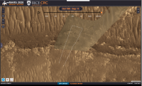
'Phil Stooke' ... I still don't have a path for the last Ingenuity flight...
I don't know where they get their data, but RICE CRC have this for flight 13 LINK
|
|
|
|
|
|
|
Sep 12 2021, 12:51 AM
Post
#185
|
|
|
Founder Group: Chairman Posts: 14432 Joined: 8-February 04 Member No.: 1 |
QUOTE (PaulH51 @ Sep 11 2021, 03:54 PM) I don't know where they get their data, I believe they recreate a flight path using the Navcam images from the chopper. |
|
|
|
|
Sep 12 2021, 02:09 AM
Post
#186
|
||
|
Solar System Cartographer Group: Members Posts: 10151 Joined: 5-April 05 From: Canada Member No.: 227 |
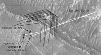
Thanks - I was just in the process of creating my own version with the DTE images:
The path Paul posted fits this very closely. Phil -------------------- ... because the Solar System ain't gonna map itself.
Also to be found posting similar content on https://mastodon.social/@PhilStooke Maps for download (free PD: https://upload.wikimedia.org/wikipedia/comm...Cartography.pdf NOTE: everything created by me which I post on UMSF is considered to be in the public domain (NOT CC, public domain) |
|
|
|
|
|
|
Sep 12 2021, 05:47 PM
Post
#187
|
||
|
Solar System Cartographer Group: Members Posts: 10151 Joined: 5-April 05 From: Canada Member No.: 227 |
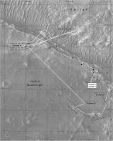
Sol 200 - a very long drive, about 160 or 170 m, a record for Perseverance and longer than any drive by Curiosity.
Phil
-------------------- ... because the Solar System ain't gonna map itself.
Also to be found posting similar content on https://mastodon.social/@PhilStooke Maps for download (free PD: https://upload.wikimedia.org/wikipedia/comm...Cartography.pdf NOTE: everything created by me which I post on UMSF is considered to be in the public domain (NOT CC, public domain) |
|
|
|
|
|
|
Sep 12 2021, 07:12 PM
Post
#188
|
|
|
Senior Member Group: Members Posts: 2428 Joined: 30-January 13 From: Penang, Malaysia. Member No.: 6853 |
QUOTE (Phil Stooke @ Sep 13 2021, 01:47 AM) Sol 200 - a very long drive, about 160 or 170 m, a record for perseverance and longer than any drive by Curiosity. Geojson reports the drive as: 169.854551 meters   |
|
|
|
|
Sep 13 2021, 05:23 PM
Post
#189
|
||
|
Solar System Cartographer Group: Members Posts: 10151 Joined: 5-April 05 From: Canada Member No.: 227 |
Sol 201, a shorter drive down the slope.
Phil
-------------------- ... because the Solar System ain't gonna map itself.
Also to be found posting similar content on https://mastodon.social/@PhilStooke Maps for download (free PD: https://upload.wikimedia.org/wikipedia/comm...Cartography.pdf NOTE: everything created by me which I post on UMSF is considered to be in the public domain (NOT CC, public domain) |
|
|
|
|
|
|
Sep 15 2021, 02:50 AM
Post
#190
|
||
|
Solar System Cartographer Group: Members Posts: 10151 Joined: 5-April 05 From: Canada Member No.: 227 |
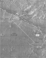
Out into the sandy wilds of South Seitah. Or if you prefer, Seitah South.
Phil
-------------------- ... because the Solar System ain't gonna map itself.
Also to be found posting similar content on https://mastodon.social/@PhilStooke Maps for download (free PD: https://upload.wikimedia.org/wikipedia/comm...Cartography.pdf NOTE: everything created by me which I post on UMSF is considered to be in the public domain (NOT CC, public domain) |
|
|
|
|
|
|
Sep 15 2021, 09:46 PM
Post
#191
|
||
|
Solar System Cartographer Group: Members Posts: 10151 Joined: 5-April 05 From: Canada Member No.: 227 |
Sol 203, approaching the rocky hill.
Phil
-------------------- ... because the Solar System ain't gonna map itself.
Also to be found posting similar content on https://mastodon.social/@PhilStooke Maps for download (free PD: https://upload.wikimedia.org/wikipedia/comm...Cartography.pdf NOTE: everything created by me which I post on UMSF is considered to be in the public domain (NOT CC, public domain) |
|
|
|
|
|
|
Sep 17 2021, 07:33 AM
Post
#192
|
||
|
Solar System Cartographer Group: Members Posts: 10151 Joined: 5-April 05 From: Canada Member No.: 227 |
Sol 204. This might be the next drill site - if it passes its medical.
Phil
-------------------- ... because the Solar System ain't gonna map itself.
Also to be found posting similar content on https://mastodon.social/@PhilStooke Maps for download (free PD: https://upload.wikimedia.org/wikipedia/comm...Cartography.pdf NOTE: everything created by me which I post on UMSF is considered to be in the public domain (NOT CC, public domain) |
|
|
|
|
|
|
Sep 22 2021, 08:41 PM
Post
#193
|
||
|
Solar System Cartographer Group: Members Posts: 10151 Joined: 5-April 05 From: Canada Member No.: 227 |
Well, it didn't pass its medical by the look of it. Sol 210, another drive. The single front Hazcam image we have is enough to give a location but the path I show is just a guess until I know more.
Phil
-------------------- ... because the Solar System ain't gonna map itself.
Also to be found posting similar content on https://mastodon.social/@PhilStooke Maps for download (free PD: https://upload.wikimedia.org/wikipedia/comm...Cartography.pdf NOTE: everything created by me which I post on UMSF is considered to be in the public domain (NOT CC, public domain) |
|
|
|
|
|
|
Sep 26 2021, 06:43 AM
Post
#194
|
|
|
Senior Member Group: Members Posts: 1043 Joined: 17-February 09 Member No.: 4605 |
Your dedication to mapping is much appreciated Phil.
|
|
|
|
|
Oct 2 2021, 04:44 PM
Post
#195
|
|
|
Senior Member Group: Members Posts: 2998 Joined: 30-October 04 Member No.: 105 |
Is Perseverance parked in her Conjunction parking space since Sol 210?
-------------------- |
|
|
|
|

|
Lo-Fi Version | Time is now: 25th April 2024 - 02:52 PM |
|
RULES AND GUIDELINES Please read the Forum Rules and Guidelines before posting. IMAGE COPYRIGHT |
OPINIONS AND MODERATION Opinions expressed on UnmannedSpaceflight.com are those of the individual posters and do not necessarily reflect the opinions of UnmannedSpaceflight.com or The Planetary Society. The all-volunteer UnmannedSpaceflight.com moderation team is wholly independent of The Planetary Society. The Planetary Society has no influence over decisions made by the UnmannedSpaceflight.com moderators. |
SUPPORT THE FORUM Unmannedspaceflight.com is funded by the Planetary Society. Please consider supporting our work and many other projects by donating to the Society or becoming a member. |
|