To the Cape! (part 2), For real this time! |

  |
To the Cape! (part 2), For real this time! |
 Jun 26 2008, 03:34 PM Jun 26 2008, 03:34 PM
Post
#76
|
|
 The Poet Dude  Group: Moderator Posts: 5551 Joined: 15-March 04 From: Kendal, Cumbria, UK Member No.: 60 |
-------------------- |
 |
 
|
|
Jun 26 2008, 08:22 PM
Post
#77
|
|
 Senior Member Group: Moderator Posts: 2262 Joined: 9-February 04 From: Melbourne - Oz Member No.: 16 |
Today's offering.
 James -------------------- |
|
|
|
|
Jun 27 2008, 04:52 PM
Post
#78
|
||
 Senior Member Group: Members Posts: 4246 Joined: 17-January 05 Member No.: 152 |
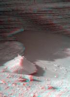
Another sol, another spectacular set of pancams - here's one of my favourite views, in 3D:
|
|
|
|
|
|
|
Jun 27 2008, 05:21 PM
Post
#79
|
||
 Member Group: Members Posts: 568 Joined: 20-April 05 From: Silesia Member No.: 299 |
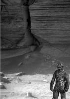
My favourite views:
http://qt.exploratorium.edu/mars/opportuni...B0P2266L2M1.JPG http://qt.exploratorium.edu/mars/opportuni...B0P2266R2M1.JPG Looks like frames from old science fiction movie (Star Trek).
-------------------- Free software for planetary science (including Cassini Image Viewer).
http://members.tripod.com/petermasek/marinerall.html |
|
|
|
|
|
|
Jun 27 2008, 06:14 PM
Post
#80
|
|
|
Senior Member Group: Moderator Posts: 2262 Joined: 9-February 04 From: Melbourne - Oz Member No.: 16 |
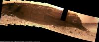
Just one image short of completing the sol 1570/1 bit now. It's becoming an amazing view!
  Still this is only half of the total pan taken so far if you include those from sols 1572/3 that are still on the rover.  James -------------------- |
|
|
|
|
Jun 27 2008, 10:29 PM
Post
#81
|
||
 Senior Member Group: Members Posts: 2492 Joined: 15-January 05 From: center Italy Member No.: 150 |
Superb mosaic, James, even with dirt and unfilled rectangle...
Edit: Here I tried to reduce effects of dirt and glare in the half res version:
Attached thumbnail(s)
-------------------- I always think before posting! - Marco -
|
|
|
|
|
|
|
Jun 28 2008, 01:38 AM
Post
#82
|
|
 Member Group: Members Posts: 656 Joined: 20-April 05 From: League City, Texas Member No.: 285 |
QUOTE (peter59 @ Jun 27 2008, 11:21 AM)  The discontinuity between the thick central unit and the lower unit is interesting. Those lower layers seem to be at a significantly different orientation than in the upper. |
|
|
|
|
Jun 28 2008, 02:01 AM
Post
#83
|
|
 Senior Member Group: Moderator Posts: 2785 Joined: 10-November 06 From: Pasadena, CA Member No.: 1345 |
QUOTE (algorimancer @ Jun 27 2008, 08:38 PM) The discontinuity between the thick central unit and the lower unit is interesting. Those lower layers seem to be at a significantly different orientation than in the upper. Very interesting observation! Anyone got a possible explanation? -------------------- Some higher resolution images available at my photostream: http://www.flickr.com/photos/31678681@N07/
|
|
|
|
|
Jun 28 2008, 02:10 AM
Post
#84
|
|
|
Merciless Robot Group: Admin Posts: 8783 Joined: 8-December 05 From: Los Angeles Member No.: 602 |
Mmm...differential weathering? I've seen apparent discontinuities like this in the past on Earth; maybe the prevailing wind path around the two vertically separated regions is just different enough to cause the disparity. (I'm assuming that the whole formation is old, old, old...)
-------------------- A few will take this knowledge and use this power of a dream realized as a force for change, an impetus for further discovery to make less ancient dreams real.
|
|
|
|
|
Jun 28 2008, 03:40 AM
Post
#85
|
|
|
Senior Member Group: Moderator Posts: 2785 Joined: 10-November 06 From: Pasadena, CA Member No.: 1345 |
I'm wondering if we are seeing deposition, tilting of strata, erosion of upper section of tilted strata, then redeposition of upper layers of strata.
That would imply the lower layers are old, AND had an interesting history prior to the deposition of the upper strata. -Mike -------------------- Some higher resolution images available at my photostream: http://www.flickr.com/photos/31678681@N07/
|
|
|
|
|
Jun 28 2008, 04:01 AM
Post
#86
|
|
|
Solar System Cartographer Group: Members Posts: 10146 Joined: 5-April 05 From: Canada Member No.: 227 |
No - much more likely to be just cross-bedding - i.e. cemented dune sandstones.
Phil -------------------- ... because the Solar System ain't gonna map itself.
Also to be found posting similar content on https://mastodon.social/@PhilStooke NOTE: everything created by me which I post on UMSF is considered to be in the public domain (NOT CC, public domain) |
|
|
|
|
Jun 28 2008, 04:23 AM
Post
#87
|
|
|
Senior Member Group: Moderator Posts: 2785 Joined: 10-November 06 From: Pasadena, CA Member No.: 1345 |
QUOTE (Phil Stooke @ Jun 27 2008, 11:01 PM) No - much more likely to be just cross-bedding - i.e. cemented dune sandstones. Phil I thought cross bedding had little "wedgie" shapes? -------------------- Some higher resolution images available at my photostream: http://www.flickr.com/photos/31678681@N07/
|
|
|
|
|
Jun 28 2008, 05:06 AM
Post
#88
|
|
|
Senior Member Group: Members Posts: 2998 Joined: 30-October 04 Member No.: 105 |
At first glance it looks like truncated cross-beds or an unconformity, which is consistent with the aeolian dune-playa setting. We've seen this at several places in Endurance and Victoria. But if you look closely at the lower beds, you can see a fabric of essentially horizontal beds, morte or less parallel to the upper beds. So I'm thinking that one or the other orientation of the lower bed may be an artifact of aeolian erosion. We need an up-close look. We'll also be able to tell more once Oppy starts taking images out of the flat (shadowed) light.
Of more interest is the open fracture in the upper beds. Is it a solution cavity, or what? Another example of the x-bedding is in 1P259578369EFF8900P2570L6M1. --Bill -------------------- |
|
|
|
|
Jun 28 2008, 05:55 AM
Post
#89
|
|
 Senior Member Group: Members Posts: 1229 Joined: 24-December 05 From: The blue one in between the yellow and red ones. Member No.: 618 |
Ultimately, these questions all hearken back to the formation of the cape-and-bay crater rim. Why are the bays eroded down the strata at a 20 - 30 degree angle, while the capes are cut down more or less vertically. I can't believe that this is due to a more resistant sediment formation in the capes, neatly interspersed with less resistant strata in the bays. Until somebody lays out a plausible hypothesis for the formation of Victoria's sinuous rim, I don't think this little microcosmic curiosity at the base of one cape can be understood.
-------------------- My Grandpa goes to Mars every day and all I get are these lousy T-shirts!
|
|
|
|
|
Jun 28 2008, 07:31 AM
Post
#90
|
|
 Senior Member Group: Admin Posts: 4763 Joined: 15-March 05 From: Glendale, AZ Member No.: 197 |
QUOTE (Shaka @ Jun 27 2008, 09:55 PM) Why are the bays eroded down the strata at a 20 - 30 degree angle, while the capes are cut down more or less vertically. Primarily: Capes have greater exposure to the prominent erosion forces - prevailing winds. As a result they are in a less stable vertical condition. The bays are set back and more sheltered from the prevailing winds so they are older and have had time to slump. As an example go dig some holes in your yard, one each month. After a year see what the sides of the holes are like. The newest holes will have the steepest sides, the older holes will have slumped in on themselves. Secondarily: The capes by virtue of their recessed shape are traps for the heavier particles that the winds are unable to lift from the crater. This back and forth of capes and bays likely occurs in a manner analogous to a meandering stream. Over the eons the shapes will migrate back and forth as bays fill up and capes are eroded away...and the crater grows ever larger (assuming some external condition doesn't cause it to become filled in by migrating sand dunes or such.) -------------------- If Occam had heard my theory, things would be very different now.
|
|
|
|
|

|
Lo-Fi Version | Time is now: 19th April 2024 - 10:50 AM |
|
RULES AND GUIDELINES Please read the Forum Rules and Guidelines before posting. IMAGE COPYRIGHT |
OPINIONS AND MODERATION Opinions expressed on UnmannedSpaceflight.com are those of the individual posters and do not necessarily reflect the opinions of UnmannedSpaceflight.com or The Planetary Society. The all-volunteer UnmannedSpaceflight.com moderation team is wholly independent of The Planetary Society. The Planetary Society has no influence over decisions made by the UnmannedSpaceflight.com moderators. |
SUPPORT THE FORUM Unmannedspaceflight.com is funded by the Planetary Society. Please consider supporting our work and many other projects by donating to the Society or becoming a member. |
|