China to the Moon - Chang'e 1 and 2, Chinese unmanned lunar orbiters |

  |
China to the Moon - Chang'e 1 and 2, Chinese unmanned lunar orbiters |
 Mar 3 2009, 05:01 AM Mar 3 2009, 05:01 AM
Post
#121
|
||
|
Solar System Cartographer  Group: Members Posts: 10151 Joined: 5-April 05 From: Canada Member No.: 227 |
A stretched out version - easier to try to locate it. But I don't recognize the area. This has north up, from the lighting direction, if it's taken on the last orbit.
Phil
-------------------- ... because the Solar System ain't gonna map itself.
Also to be found posting similar content on https://mastodon.social/@PhilStooke Maps for download (free PD: https://upload.wikimedia.org/wikipedia/comm...Cartography.pdf NOTE: everything created by me which I post on UMSF is considered to be in the public domain (NOT CC, public domain) |
|
 |
 
|
|
|
Aug 6 2009, 03:13 PM
Post
#122
|
|
 Senior Member Group: Members Posts: 1729 Joined: 3-August 06 From: 43° 35' 53" N 1° 26' 35" E Member No.: 1004 |
|
|
|
|
|
Sep 28 2009, 08:56 PM
Post
#123
|
|
|
Senior Member Group: Members Posts: 1729 Joined: 3-August 06 From: 43° 35' 53" N 1° 26' 35" E Member No.: 1004 |
This Aviation Week article http://www.aviationweek.com/aw/generic/sto...china092809.xml is mostly about MSF, but it does say that Chang'e 2 will fly in October 2010.
"Improvements include a better camera with a resolution of 5 meters (16.4 ft.) at the surface, they say." |
|
|
|
| Guest_Zvezdichko_* |
Nov 27 2009, 10:13 AM
Post
#124
|
|
Guests |
http://www.novosti-kosmonavtiki.ru/content/news.shtml
Novosti-Kosmonavtiki confirms launch in October 2010 and it is also said that Chang'e 2 will be 100 kms closer to the lunar surface. It's also said that the instruments will be even more sophisticated and powerful, but I don't know about the resolution of the camera. Chang'e 2 will be based on a back-up spacecraft for Chang'e 1 already built. Initially it was supposed to be launched as-is, as a clone of Chang'e 1, but now it's confirmed it will carry more powerful instruments. Novosti-Kosmonavtiki also says the moon rover will be launched no later than 2013. The moon rover will study the local resources, particularly minerals. The rover will be a stepping stone to a human mission to the Moon, which has to occur no later than 2030. |
|
|
|
| Guest_Zvezdichko_* |
Dec 2 2009, 01:39 PM
Post
#125
|
|
Guests |
http://www.spacedaily.com/reports/Change_1...ration_999.html
A new article plus a thumbnail of the topographic map. Do you have any idea if we already have a bigger version somewhere? http://www.physorg.com/newman/gfx/news/hir...hange1hasbl.jpg |
|
|
|
|
Dec 3 2009, 01:50 AM
Post
#126
|
|
|
Merciless Robot Group: Admin Posts: 8783 Joined: 8-December 05 From: Los Angeles Member No.: 602 |
100 km closer using the same spacecraft bus & upgraded instruments, eh? They don't seem too worried about thermal problems.
-------------------- A few will take this knowledge and use this power of a dream realized as a force for change, an impetus for further discovery to make less ancient dreams real.
|
|
|
|
|
Dec 3 2009, 02:10 PM
Post
#127
|
|
 Senior Member Group: Members Posts: 1419 Joined: 26-July 08 Member No.: 4270 |
Perhaps with the information gained from their first lunar mission, they're confident they'll be able to handle it. On the other hand, if they suddenly consider raising altitude for a better view, we'll know what's happening

-------------------- -- Hungry4info (Sirius_Alpha)
|
|
|
|
|
Dec 3 2009, 03:11 PM
Post
#128
|
|
|
Solar System Cartographer Group: Members Posts: 10151 Joined: 5-April 05 From: Canada Member No.: 227 |
LRO's at 50 km and it's not bothering them.
Phil -------------------- ... because the Solar System ain't gonna map itself.
Also to be found posting similar content on https://mastodon.social/@PhilStooke Maps for download (free PD: https://upload.wikimedia.org/wikipedia/comm...Cartography.pdf NOTE: everything created by me which I post on UMSF is considered to be in the public domain (NOT CC, public domain) |
|
|
|
|
Dec 4 2009, 01:45 AM
Post
#129
|
|
|
Merciless Robot Group: Admin Posts: 8783 Joined: 8-December 05 From: Los Angeles Member No.: 602 |
Surely. I was being kind of elliptical; it appears that they are quite confident in their basic design is what I meant.
-------------------- A few will take this knowledge and use this power of a dream realized as a force for change, an impetus for further discovery to make less ancient dreams real.
|
|
|
|
|
Dec 5 2009, 11:47 AM
Post
#130
|
|||
|
Junior Member Group: Members Posts: 57 Joined: 21-September 06 Member No.: 1172 |
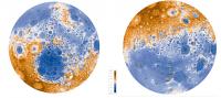
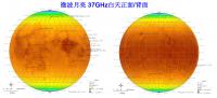
QUOTE (Zvezdichko @ Dec 2 2009, 01:39 PM)  Do you have any idea if we already have a bigger version somewhere? Yes, we have. See attachments below. First one is topographical map from Chang'e Laser Altimeter with North/South pole views presented. Second one is a kind of microwave map at 37 GHz. I can't translate the title, but I suppose it presents a microwave emissivity of the moon regolith.
Attached thumbnail(s)
|
||
|
|
|
||
|
Dec 5 2009, 03:19 PM
Post
#131
|
|
|
Newbie Group: Members Posts: 3 Joined: 21-December 06 Member No.: 1502 |
微波月亮 34Ghz 白天正面/背面
microwave moon 34Ghz Daytime Frontside/Backside |
|
|
|
|
Aug 25 2010, 10:16 PM
Post
#132
|
|
|
Solar System Cartographer Group: Members Posts: 10151 Joined: 5-April 05 From: Canada Member No.: 227 |
(checking in from vacation)
(like, who can stay away from UMSF even if a vacation is supposed to be happening?) So now I hear that Chang-e 2, the Moon orbiter due to launch in October this year, will be carrying a small lunar impact probe, as Chandrayaan 1 did. Presumably it will be testing tracking, altimetry etc., and maybe imaging down to the surface in support of the lander scheduled for 2013. Phil -------------------- ... because the Solar System ain't gonna map itself.
Also to be found posting similar content on https://mastodon.social/@PhilStooke Maps for download (free PD: https://upload.wikimedia.org/wikipedia/comm...Cartography.pdf NOTE: everything created by me which I post on UMSF is considered to be in the public domain (NOT CC, public domain) |
|
|
|
|
Aug 28 2010, 02:37 PM
Post
#133
|
|
 Member Group: Members Posts: 610 Joined: 23-February 07 From: Occasionally in Columbia, MD Member No.: 1764 |
QUOTE (IM4 @ Dec 5 2009, 06:47 AM) I can't translate the title, but I suppose it presents a microwave emissivity of the moon regolith. Microwave brightness temperature (there is a color scalebar in K on the plot..) This has an emissivity contribution, but is dominated by the physical temperature which in this case is dominated by latitude. There have been a few papers published on these (nice) data - possibly some of the most solid results from Chang'e so far, or at least results complementary to what everyone else has flown. e.g. LPSC abstract http://www.lpi.usra.edu/meetings/lpsc2010/pdf/1331.pdf |
|
|
|
|
Sep 21 2010, 06:34 PM
Post
#134
|
|
|
Senior Member Group: Members Posts: 1729 Joined: 3-August 06 From: 43° 35' 53" N 1° 26' 35" E Member No.: 1004 |
Lunar microwave temperature maps presented at EPSC
http://lunarscience.arc.nasa.gov/articles/...e-complete-moon |
|
|
|
|
Sep 30 2010, 01:47 PM
Post
#135
|
|
|
Junior Member Group: Members Posts: 86 Joined: 12-October 05 From: Beijing Member No.: 526 |
Chang'e 2 will be launched at 10:59:57 UTC, tomorrow.
Wikipedia: http://en.wikipedia.org/wiki/Chang'e_2 Pictures: http://slide.news.sina.com.cn/c/slide_1_15699_13288.html |
|
|
|
|

|
Lo-Fi Version | Time is now: 26th April 2024 - 08:49 AM |
|
RULES AND GUIDELINES Please read the Forum Rules and Guidelines before posting. IMAGE COPYRIGHT |
OPINIONS AND MODERATION Opinions expressed on UnmannedSpaceflight.com are those of the individual posters and do not necessarily reflect the opinions of UnmannedSpaceflight.com or The Planetary Society. The all-volunteer UnmannedSpaceflight.com moderation team is wholly independent of The Planetary Society. The Planetary Society has no influence over decisions made by the UnmannedSpaceflight.com moderators. |
SUPPORT THE FORUM Unmannedspaceflight.com is funded by the Planetary Society. Please consider supporting our work and many other projects by donating to the Society or becoming a member. |
|