Yutu-2 route map |

  |
Yutu-2 route map |
 Feb 18 2019, 12:12 AM Feb 18 2019, 12:12 AM
Post
#16
|
||
|
Solar System Cartographer  Group: Members Posts: 10229 Joined: 5-April 05 From: Canada Member No.: 227 |
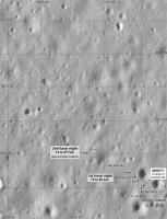
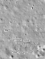
No new information really, except the total distance driven (120 m) and an azimuth derived from the latest image of the lander against the hills of the SE horizon... but here is a new map showing the approximate location of Yutu-2 during the second night. The background image needs some minor adjustment of scale and position which I will deal with as soon as I can.
Phil
-------------------- ... because the Solar System ain't gonna map itself.
Also to be found posting similar content on https://mastodon.social/@PhilStooke Maps for download (free PDF: https://upload.wikimedia.org/wikipedia/comm...Cartography.pdf NOTE: everything created by me which I post on UMSF is considered to be in the public domain (NOT CC, public domain) |
|
 |
 
|
|
|
Feb 18 2019, 07:34 AM
Post
#17
|
|
 Member Group: Members Posts: 559 Joined: 1-May 06 From: Scotland (Ecosse, Escocia) Member No.: 759 |
So it has now exceeded the drive distance of Yutu-1?
|
|
|
|
|
Feb 18 2019, 03:33 PM
Post
#18
|
|
|
Member Group: Members Posts: 279 Joined: 19-August 07 Member No.: 3299 |
A recent picture from LRO on Chang'e-4' landing site
http://www.spxdaily.com/images-hg/far-side...619844lr-hg.jpg Further details: http://www.moondaily.com/reports/IAU_names...f_Moon_999.html |
|
|
|
|
Feb 18 2019, 06:33 PM
Post
#19
|
|
|
Solar System Cartographer Group: Members Posts: 10229 Joined: 5-April 05 From: Canada Member No.: 227 |
Yes, Kenny, it has exceeded the first Yutu's distance. And Sojourner's.
Phil -------------------- ... because the Solar System ain't gonna map itself.
Also to be found posting similar content on https://mastodon.social/@PhilStooke Maps for download (free PDF: https://upload.wikimedia.org/wikipedia/comm...Cartography.pdf NOTE: everything created by me which I post on UMSF is considered to be in the public domain (NOT CC, public domain) |
|
|
|
|
Feb 18 2019, 09:50 PM
Post
#20
|
|
|
Member Group: Members Posts: 157 Joined: 22-May 09 From: Ireland Member No.: 4792 |
Phil...to see rover tracks: presuming LRO will lower its in-orbit altitude downwards?
John |
|
|
|
|
Feb 19 2019, 02:14 AM
Post
#21
|
|
|
Solar System Cartographer Group: Members Posts: 10229 Joined: 5-April 05 From: Canada Member No.: 227 |
No, don't look for any change in the orbit, they are conserving fuel. But images with higher sun angles will show the tracks very well. They show up in Chang'e 3 images from LRO at a higher altitude. What I really need is a Chinese map of the path, better than the oblique rendering we have seen up to now.
Phil -------------------- ... because the Solar System ain't gonna map itself.
Also to be found posting similar content on https://mastodon.social/@PhilStooke Maps for download (free PDF: https://upload.wikimedia.org/wikipedia/comm...Cartography.pdf NOTE: everything created by me which I post on UMSF is considered to be in the public domain (NOT CC, public domain) |
|
|
|
|
Feb 28 2019, 12:43 AM
Post
#22
|
||
|
Solar System Cartographer Group: Members Posts: 10229 Joined: 5-April 05 From: Canada Member No.: 227 |
Thanks, John.
Here is an update based on a map seen on the 9ifly forum. That map has some issues but for now it is the best source I have. I'm hoping to see a map at LPSC in a few weeks. Note that the base image has been adjusted a bit since the last map. Phil
-------------------- ... because the Solar System ain't gonna map itself.
Also to be found posting similar content on https://mastodon.social/@PhilStooke Maps for download (free PDF: https://upload.wikimedia.org/wikipedia/comm...Cartography.pdf NOTE: everything created by me which I post on UMSF is considered to be in the public domain (NOT CC, public domain) |
|
|
|
|
|
|
Mar 4 2019, 04:11 PM
Post
#23
|
|
 Administrator Group: Admin Posts: 5172 Joined: 4-August 05 From: Pasadena, CA, USA, Earth Member No.: 454 |
Just a reminder that the route map threads are strictly for posting route maps; please converse about mission operations in the appropriate thread.
-------------------- My website - My Patreon - @elakdawalla on Twitter - Please support unmannedspaceflight.com by donating here.
|
|
|
|
|
Mar 4 2019, 08:06 PM
Post
#24
|
||
|
Solar System Cartographer Group: Members Posts: 10229 Joined: 5-April 05 From: Canada Member No.: 227 |
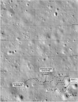
A very approximate location for our current position. It is based on the distance travelled, 7 m, an assumption that some of that was taken up with maneuvering to get the rock in the instrument field of view, and an interpretation of the wide angle image.
Phil
-------------------- ... because the Solar System ain't gonna map itself.
Also to be found posting similar content on https://mastodon.social/@PhilStooke Maps for download (free PDF: https://upload.wikimedia.org/wikipedia/comm...Cartography.pdf NOTE: everything created by me which I post on UMSF is considered to be in the public domain (NOT CC, public domain) |
|
|
|
|
|
|
Mar 13 2019, 03:47 AM
Post
#25
|
||
|
Solar System Cartographer Group: Members Posts: 10229 Joined: 5-April 05 From: Canada Member No.: 227 |
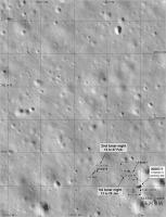
Another iteration of the map. I wanted to get the first 2 lunar days on the close-up map.
Phil
-------------------- ... because the Solar System ain't gonna map itself.
Also to be found posting similar content on https://mastodon.social/@PhilStooke Maps for download (free PDF: https://upload.wikimedia.org/wikipedia/comm...Cartography.pdf NOTE: everything created by me which I post on UMSF is considered to be in the public domain (NOT CC, public domain) |
|
|
|
|
|
|
Mar 22 2019, 03:34 AM
Post
#26
|
||
|
Solar System Cartographer Group: Members Posts: 10229 Joined: 5-April 05 From: Canada Member No.: 227 |
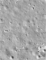
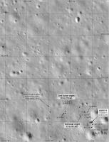
A map update using the new LRO image to get an exact position for the second lunar night (it only needed a very small correction). I also estimate where the third lunar night location is.
Phil
-------------------- ... because the Solar System ain't gonna map itself.
Also to be found posting similar content on https://mastodon.social/@PhilStooke Maps for download (free PDF: https://upload.wikimedia.org/wikipedia/comm...Cartography.pdf NOTE: everything created by me which I post on UMSF is considered to be in the public domain (NOT CC, public domain) |
|
|
|
|
|
|
Mar 25 2019, 05:58 PM
Post
#27
|
||
|
Solar System Cartographer Group: Members Posts: 10229 Joined: 5-April 05 From: Canada Member No.: 227 |
Andrew Jones tweeted a map here:
https://twitter.com/AJ_FI/status/1110035767697567746 (plus a nice image of tracks) which allows me to update our map. Note that the Chinese map does not distinguish between daily end-of-drive locations and mid-drive waypoints, which I try to do in my map. In the later parts of the route there are too many stops for days, so some are waypoints. When I know which are which I can add date labels to stops. Phil
-------------------- ... because the Solar System ain't gonna map itself.
Also to be found posting similar content on https://mastodon.social/@PhilStooke Maps for download (free PDF: https://upload.wikimedia.org/wikipedia/comm...Cartography.pdf NOTE: everything created by me which I post on UMSF is considered to be in the public domain (NOT CC, public domain) |
|
|
|
|
|
|
Apr 27 2019, 12:14 PM
Post
#28
|
||
|
Solar System Cartographer Group: Members Posts: 10229 Joined: 5-April 05 From: Canada Member No.: 227 |
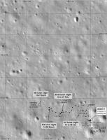
No real news but I decided to show an estimate for the new location at the end of day 4. We are told the day 4 drive was about 30 m, probably not in a straight line. I have no evidence for the location, this just lets me record the dates and I can update it when I actually know something. A new LRO image would be nice!
Phil
-------------------- ... because the Solar System ain't gonna map itself.
Also to be found posting similar content on https://mastodon.social/@PhilStooke Maps for download (free PDF: https://upload.wikimedia.org/wikipedia/comm...Cartography.pdf NOTE: everything created by me which I post on UMSF is considered to be in the public domain (NOT CC, public domain) |
|
|
|
|
|
|
May 17 2019, 05:09 PM
Post
#29
|
||
|
Solar System Cartographer Group: Members Posts: 10229 Joined: 5-April 05 From: Canada Member No.: 227 |
This is a slightly tentative route map up to day 5, with the day 4 drive estimated from day 4 tracks visible in the new images. When I realized that the early day 3 rocks were visible in the track images I understood the track images better. The positions are still only approximate for the 4th day.
Phil
-------------------- ... because the Solar System ain't gonna map itself.
Also to be found posting similar content on https://mastodon.social/@PhilStooke Maps for download (free PDF: https://upload.wikimedia.org/wikipedia/comm...Cartography.pdf NOTE: everything created by me which I post on UMSF is considered to be in the public domain (NOT CC, public domain) |
|
|
|
|
|
|
Jun 10 2019, 07:00 PM
Post
#30
|
||
|
Solar System Cartographer Group: Members Posts: 10229 Joined: 5-April 05 From: Canada Member No.: 227 |
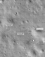
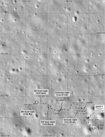
China isn't exactly making my life easy at the moment, and my maps will not improve much until a Chinese version appears. Most likely that will be in a journal article in the coming months.
However, here is my current version of the map. The 6th night location is an estimate with very little (OK, nothing) to support it. I have plotted the 5th night location a little more securely from the latest images of tracks and a crater to the south. Anyone who spots new information - let me know! Phil
-------------------- ... because the Solar System ain't gonna map itself.
Also to be found posting similar content on https://mastodon.social/@PhilStooke Maps for download (free PDF: https://upload.wikimedia.org/wikipedia/comm...Cartography.pdf NOTE: everything created by me which I post on UMSF is considered to be in the public domain (NOT CC, public domain) |
|
|
|
|
|
|

|
Lo-Fi Version | Time is now: 26th September 2024 - 10:41 PM |
|
RULES AND GUIDELINES Please read the Forum Rules and Guidelines before posting. IMAGE COPYRIGHT |
OPINIONS AND MODERATION Opinions expressed on UnmannedSpaceflight.com are those of the individual posters and do not necessarily reflect the opinions of UnmannedSpaceflight.com or The Planetary Society. The all-volunteer UnmannedSpaceflight.com moderation team is wholly independent of The Planetary Society. The Planetary Society has no influence over decisions made by the UnmannedSpaceflight.com moderators. |
SUPPORT THE FORUM Unmannedspaceflight.com is funded by the Planetary Society. Please consider supporting our work and many other projects by donating to the Society or becoming a member. |
|