Printable Version of Topic
Click here to view this topic in its original format
Unmanned Spaceflight.com _ Cassini general discussion and science results _ Satellite Feature Maps
Posted by: scalbers Feb 26 2012, 07:00 PM
Greetings,
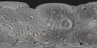
Here's a map with a feature overlay for Mimas:
|
Full resolution here: http://laps.noaa.gov/albers/sos/features/combined_mimas_lon_180_center.png
Steve
Posted by: scalbers Feb 26 2012, 07:42 PM
I had earlier shown Enceladus in the post here: http://www.unmannedspaceflight.com/index.php?s=&showtopic=6995&view=findpost&p=183110
So in this post I'll go ahead and attach Tethys:
|
Full Resolution here: http://laps.noaa.gov/albers/sos/features/combined_tethys_lon_180_center.png
Dione is posted in a separate thread here: http://www.unmannedspaceflight.com/index.php?s=&showtopic=1540&view=findpost&p=183137
Steve
Posted by: scalbers Feb 27 2012, 09:13 PM
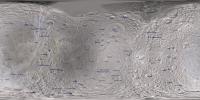
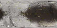
Next in line is Rhea - here's what I have so far:
|
Full Resolution: http://laps.noaa.gov/albers/sos/features/combined_rhea_lon_180_center.png
Steve
Posted by: MarcF Feb 28 2012, 10:13 AM
Hey Steve,
Thank you very much for this great work. I really enjoy these maps. The best maps with all the names ! A dream for me !!
Marc
PS:
I think you just missed Izanami and Izanagi in the Rhea map.
Posted by: scalbers Mar 3 2012, 05:37 PM
Marc, thanks for the comments and useful feedback. The features that had unspecified sizes in the USGS database (including Izanami and Izanagi) had been omitted from the map. They are there now!
I also did some rotations with some of the linear features names (those Catanae, Chasmata and such).
|
Full Resolution: http://laps.noaa.gov/albers/sos/features/combined_rhea_lon_180_center.png
Posted by: scalbers Mar 3 2012, 08:25 PM
For Titan, please check this thread:
http://www.unmannedspaceflight.com/index.php?s=&showtopic=3168&view=findpost&p=183275
Posted by: scalbers Mar 4 2012, 04:26 PM
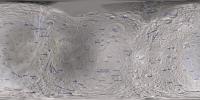
This is what I have for Iapetus, with special attention given to the Mons and Montes features.
|
Full Resolution (updated): http://laps.noaa.gov/albers/sos/features/combined_iapetus_lon_180_center.png
In the full resolution version I placed the label for Saragossa Terra farther southwest than where the USGS database is putting it, so it lies more squarely in the brighter terrain.
Steve
Posted by: scalbers Mar 16 2012, 06:28 PM
Here's what I have for a Phoebe feature map so far:
|
This uses the Cassini December 2005 map release PIA07775. There was a subsequent cartographic map release (e.g. PIA07795) that has some higher resolution imagery. However so far I've unable to find this version in a clean (unlabeled) cylindrical projection. The difference in the imagery is particularly noticeable around the craters Amphion and Eurytion.
Steve
Powered by Invision Power Board (http://www.invisionboard.com)
© Invision Power Services (http://www.invisionpower.com)