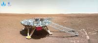
Zhurong Lander/Rover, Surface Operations at Utopia Planitia |

  |
Zhurong Lander/Rover, Surface Operations at Utopia Planitia |
 Jul 30 2021, 04:09 AM Jul 30 2021, 04:09 AM
Post
#301
|
||
|
Solar System Cartographer  Group: Members Posts: 10151 Joined: 5-April 05 From: Canada Member No.: 227 |
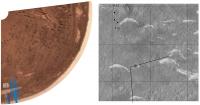
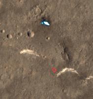
Reported on the 9ifly forum: sol 75, 708 m traversed. Waiting for pictures...
EDIT: here's a link to a picture: http://www.spaceflightfans.cn/96085.html This is a reprojection of that image (original credit to CNSA for the image) and a plot of where I think it was taken.
Phil -------------------- ... because the Solar System ain't gonna map itself.
Also to be found posting similar content on https://mastodon.social/@PhilStooke Maps for download (free PD: https://upload.wikimedia.org/wikipedia/comm...Cartography.pdf NOTE: everything created by me which I post on UMSF is considered to be in the public domain (NOT CC, public domain) |
|
 |
 
|
|
|
Jul 31 2021, 10:15 PM
Post
#302
|
|
|
Solar System Cartographer Group: Members Posts: 10151 Joined: 5-April 05 From: Canada Member No.: 227 |
First data releases! Including orbiter and rover images.
Phil http://moon.bao.ac.cn/web/zhmanager/notice...detailId=790430 Announcement on the first batch of scientific exploration data of Tianwen No.1 Release time: 2021-07-30 Views: 5 During the real-time protection period of Tianwen No. 1 mission scientific data, data is open for access. According to the Lunar Exploration and Space Engineering Center (hereinafter referred to as the Engineering Center) "Lunar and Deep Space Exploration Engineering Data Release Management Measures", the scientific data of my country's first Mars exploration mission, Tianwen-1, will be open for data access within the protection period from now on. The data released this time is produced and produced by the ground application system, including level 2B data of the Martian ion and neutral particle analyzer on the orbiter, level 2B data of the orbiter subsurface detection radar (very low frequency mode), and the terrain of the landing area of the high-resolution camera Data products, as well as the 2C level data of the Mars rover navigation terrain camera, the 2B level data of the Martian surface composition detector, the 2C level data of the Mars meteorological measuring instrument, the 2B level data of the Mars rover surface detection radar, a total of 1789 data files, the total data volume is 179.1 GB, the specific data includes: Surrounding device load: 1. Mars ion and neutral particle analyzer ( MINPA ) 2B level Scientific data 2. Surrounding device subsurface detection radar ( MOSIR ) 2B level Scientific data 3 . High-resolution camera ( HiRIC ) terrain data landing zone 4. High resolution camera ( HiRIC ) landing zone image data Rover payload: 1. Navigation terrain camera ( NaTecam ) 2C level scientific data 2. Mars Surface Composition Detector ( MarSCoDe ) Level 2B Scientific data 3. Mars rover surface detection radar ( RoPER ) 2B level Scientific data 4. Mars Meteorological Survey ( MCS ) 2C level scientific data Relevant experts with data requirements should first go to the Engineering Center to apply for data. Users who have been approved log on to this website and select the "Science Data" in the "Mars" menu bar, and click on the "Data Acquisition within Protection Period" in the Tianwen No. 1 data catalog. After registering and logging in as required, fill in the registration form and upload the data application processing form approved by the Engineering Center, and then perform data acquisition according to the process. -------------------- ... because the Solar System ain't gonna map itself.
Also to be found posting similar content on https://mastodon.social/@PhilStooke Maps for download (free PD: https://upload.wikimedia.org/wikipedia/comm...Cartography.pdf NOTE: everything created by me which I post on UMSF is considered to be in the public domain (NOT CC, public domain) |
|
|
|
|
Jul 31 2021, 11:38 PM
Post
#303
|
|
|
Founder Group: Chairman Posts: 14432 Joined: 8-February 04 Member No.: 1 |
QUOTE (Phil Stooke @ Jul 31 2021, 03:15 PM)  First data releases! Including orbiter and rover images. Arhghg - unfortunately I can't seem to log in any more. The username and password I used for a lot of Yutu 2 data hasn't changed but it's now asking for a verification code and whatever I type is just rejects it. Anyone had any luck getting in? Update Having google translate turned on was upsetting it - turning that off temporarily let me log in - but it would appear the data is available only for a limited group of people - they seem to call it a 'Protection Period' release. Access requires further registration including a long 'ID Number' and other details. |
|
|
|
|
Aug 6 2021, 06:47 AM
Post
#304
|
|
|
Solar System Cartographer Group: Members Posts: 10151 Joined: 5-April 05 From: Canada Member No.: 227 |
Sol 82, the rover has moved 100 m south since the last report (thanks to Andrew Jones for noticing this first). Total distance 808 m, and there is a rear hazcam image with tracks here:
https://mp.weixin.qq.com/s/jhwCtqGZ47gm0nCzIzYxmw There is not enough in the hazcam image for me to locate it yet. Phil -------------------- ... because the Solar System ain't gonna map itself.
Also to be found posting similar content on https://mastodon.social/@PhilStooke Maps for download (free PD: https://upload.wikimedia.org/wikipedia/comm...Cartography.pdf NOTE: everything created by me which I post on UMSF is considered to be in the public domain (NOT CC, public domain) |
|
|
|
|
Aug 17 2021, 08:37 PM
Post
#305
|
|||
 Senior Member Group: Members Posts: 1419 Joined: 26-July 08 Member No.: 4270 |
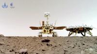
Update, basically saying the rover has completed its 90 day mission, has returned 10 Gb of data, and will continue driving south. The rover and Tianwen-1 orbiter will be put into a safe mode during solar conjunction, and will continue their mission afterward. It sounds like Tianwen-1 will leave its current orbit at that point.
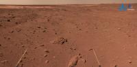
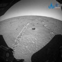
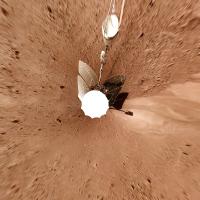
QUOTE As of August 15th, the Zhurong rover has operated on the surface of Mars for 90 Martian days and traveled a total of 889 meters. All scientific payloads have been turned on for detection and a total of approximately 10 GB of original data have been obtained, and all designed exploration missions have been completed. At present, the rover is in good working condition and has sufficient energy. In the future, the rover will launch an expansion mission and continue to drive towards the ancient land-sea junction in the southern Utopia Plain. (BACC, PEC-MARS) I've attached imagery presented in that post, but with a higher resolution found on Seger YU's twitter.
Attached thumbnail(s)
-------------------- -- Hungry4info (Sirius_Alpha)
|
||
|
|
|
||
|
Aug 18 2021, 12:39 PM
Post
#306
|
|||||||||
 Member Group: Members Posts: 185 Joined: 4-January 19 Member No.: 8523 |
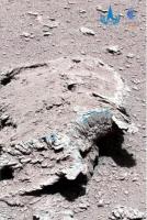
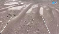
QUOTE (Hungry4info @ Aug 17 2021, 05:37 PM) I've attached imagery presented in that post, but with a higher resolution found on Seger YU's twitter. Sorry for the topic of color. But Perseverance has already started showing the pics without the red filter. Zhurong keep sending compressed blue and green channels. I think there is no need to force a perception that will not prevail when we got there. Mars resembles a Earth dry land, it doesn't looks like a red sand desert, but like a dry, or dead land, which is very nice, because it is a call for us to colonize it and a very hard remember that without care Earth will be (Exactly) a new Mars. Meanwhile, i will keep equalizing it,.. because they are just wonderfull pics, it's impossible to not be amazed about it.
Attached thumbnail(s)
-------------------- "The Earth is a very small stage in a vast cosmic arena"
|
||||||||
|
|
|
||||||||
|
Aug 23 2021, 08:38 PM
Post
#307
|
|
|
Senior Member Group: Members Posts: 1419 Joined: 26-July 08 Member No.: 4270 |
Xinhua reports that Zhurong has traveled 1 km now.
QUOTE BEIJING, Aug. 23 (Xinhua) -- China's Mars rover Zhurong had traveled more than 1,000 meters on the surface of the red planet as of Monday, the Lunar Exploration and Space Program Center of the China National Space Administration (CNSA) said.
-------------------- -- Hungry4info (Sirius_Alpha)
|
|
|
|
|
Aug 24 2021, 12:09 AM
Post
#308
|
|
|
Senior Member Group: Members Posts: 2998 Joined: 30-October 04 Member No.: 105 |
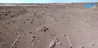
QUOTE (Huguet @ Aug 18 2021, 07:39 AM) Sorry for the topic of color. But Perseverance has already... On the sixth photo shown (a mixed white dune and reddish sand) do we know what Sol this was taken on? My Chinese is a little rusty. I can't quite match this view up with the HiRISE route maps. --Bill -------------------- |
|
|
|
|
Aug 24 2021, 10:08 AM
Post
#309
|
||||
|
Member Group: Members Posts: 185 Joined: 4-January 19 Member No.: 8523 |
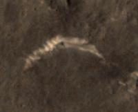
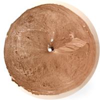
QUOTE (Bill Harris @ Aug 23 2021, 09:09 PM) On the sixth photo shown (a mixed white dune and reddish sand) do we know what Sol this was taken on? My Guess is Sol 66.
Attached thumbnail(s)
-------------------- "The Earth is a very small stage in a vast cosmic arena"
|
|||
|
|
|
|||
|
Aug 24 2021, 10:25 AM
Post
#310
|
|
|
Senior Member Group: Members Posts: 2998 Joined: 30-October 04 Member No.: 105 |
Your guess is likely correct. I wasn't looking back far enough. It does match nicely.
--Bill -------------------- |
|
|
|
|
Aug 30 2021, 10:28 AM
Post
#311
|
|||
|
Senior Member Group: Members Posts: 1419 Joined: 26-July 08 Member No.: 4270 |
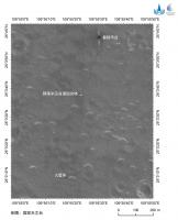
New image release. https://twitter.com/CNSAWatcher/status/1432279954868350977
QUOTE By Aug 2021, Zhurong has traveled 1.064km. The rover continues to head south. CNSA released recent panorama from Mars taken by #Zhurong and its route taken by #Tianwen1 Mars orbiter. Scientific data released at https://moon.bao.ac.cn We have a panorama from the rover, as well as an image from Tianwen-1 from orbit showing the rover at that location. There's certainly a larger version of the panorama somewhere, but I have to go to work and lack the time to search for it.
Attached thumbnail(s)
-------------------- -- Hungry4info (Sirius_Alpha)
|
||
|
|
|
||
|
Aug 30 2021, 05:43 PM
Post
#312
|
|
|
Solar System Cartographer Group: Members Posts: 10151 Joined: 5-April 05 From: Canada Member No.: 227 |
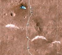
See my note in the map thread - the track seen by the orbiter does not match the new map precisely but I will wait for HiRISE before trying to update my map. I will look for a larger panorama.
Phil -------------------- ... because the Solar System ain't gonna map itself.
Also to be found posting similar content on https://mastodon.social/@PhilStooke Maps for download (free PD: https://upload.wikimedia.org/wikipedia/comm...Cartography.pdf NOTE: everything created by me which I post on UMSF is considered to be in the public domain (NOT CC, public domain) |
|
|
|
|
Aug 30 2021, 08:12 PM
Post
#313
|
|||
|
Solar System Cartographer Group: Members Posts: 10151 Joined: 5-April 05 From: Canada Member No.: 227 |
Well, you can't get a new panorama like that without giving it a bit of attention, can you? In order to remove the large variation in brightness with phase angle, I had to modify the color extensively so you can't regard it as realistic. Thanks to CNSA for the original data.
Phil
-------------------- ... because the Solar System ain't gonna map itself.
Also to be found posting similar content on https://mastodon.social/@PhilStooke Maps for download (free PD: https://upload.wikimedia.org/wikipedia/comm...Cartography.pdf NOTE: everything created by me which I post on UMSF is considered to be in the public domain (NOT CC, public domain) |
||
|
|
|
||
|
Aug 31 2021, 08:15 PM
Post
#314
|
|
|
Senior Member Group: Members Posts: 1419 Joined: 26-July 08 Member No.: 4270 |
Full resolution panorama provided to me by someone who can get the CNSA site to load for them.
 I had to convert it to .jpg, as the original .png file is about 37 Mb. Edit: Nevermind for now. Pretty pitiful upload limit. I'll update this post when I can find a way around that. Edit2: Google Drive link. https://drive.google.com/file/d/1S-LSL3xGpI...iew?usp=sharing Please consider updating the upload limit at some point if that's at all possible. It's 2021, and 3 Mb doesn't go as far as it used to. -------------------- -- Hungry4info (Sirius_Alpha)
|
|
|
|
|
Aug 31 2021, 09:12 PM
Post
#315
|
|
|
Merciless Robot Group: Admin Posts: 8783 Joined: 8-December 05 From: Los Angeles Member No.: 602 |
<admin mode>: Hey, Hungry. Thanks for posting a link to this imagery given the upload limit.
Speaking of the limit, we don't want to raise it because a- we do have a worldwide audience & not everybody has access to high-speed internet service & WiFi, and b- extremely large files can be problematic for mobile users anyhow. </admin> -------------------- A few will take this knowledge and use this power of a dream realized as a force for change, an impetus for further discovery to make less ancient dreams real.
|
|
|
|
|

|
Lo-Fi Version | Time is now: 26th April 2024 - 05:35 AM |
|
RULES AND GUIDELINES Please read the Forum Rules and Guidelines before posting. IMAGE COPYRIGHT |
OPINIONS AND MODERATION Opinions expressed on UnmannedSpaceflight.com are those of the individual posters and do not necessarily reflect the opinions of UnmannedSpaceflight.com or The Planetary Society. The all-volunteer UnmannedSpaceflight.com moderation team is wholly independent of The Planetary Society. The Planetary Society has no influence over decisions made by the UnmannedSpaceflight.com moderators. |
SUPPORT THE FORUM Unmannedspaceflight.com is funded by the Planetary Society. Please consider supporting our work and many other projects by donating to the Society or becoming a member. |
|