Southward from San Antonio to the Next Waypoint |

  |
Southward from San Antonio to the Next Waypoint |
 Apr 2 2010, 11:33 PM Apr 2 2010, 11:33 PM
Post
#16
|
|
|
Senior Member  Group: Members Posts: 2079 Joined: 13-February 10 From: Ontario Member No.: 5221 |
So even if we find the ideal terrain, like at the landing site, there will still be no 'pre-Purgatory' style drives, correct? Even Oppy is showing her age...
|
 |
 
|
|
Apr 3 2010, 03:21 AM
Post
#17
|
|
 Senior Member Group: Members Posts: 4246 Joined: 17-January 05 Member No.: 152 |
|
|
|
|
|
Apr 3 2010, 09:29 AM
Post
#18
|
|
|
Senior Member Group: Moderator Posts: 4279 Joined: 19-April 05 From: .br at .es Member No.: 253 |
QUOTE (Explorer1 @ Apr 3 2010, 01:33 AM)  So even if we find the ideal terrain, like at the landing site, there will still be no 'pre-Purgatory' style drives, correct? Even Oppy is showing her age... Correct. Due to the stress on the RF wheel and also because right now there's not enough power for long drives. And since we're talking about long drives, I think it's worth to mention Scott's blog on the rovers. Just in case there's anyone here not aware or not following that blog, the narration is currently right on those 'pre-Purgatory' days. |
|
|
|
|
Apr 3 2010, 12:42 PM
Post
#19
|
|
 Member Group: Members Posts: 754 Joined: 9-February 07 Member No.: 1700 |
thx for the pointer to Scott's blog

|
|
|
|
|
Apr 3 2010, 07:54 PM
Post
#20
|
|
|
Senior Member Group: Members Posts: 2918 Joined: 14-February 06 From: Very close to the Pyrénées Mountains (France) Member No.: 682 |
There's something I'm not sure to understand about the new AEGIS software uploaded recently. I understand that Oppy (& Spirit) can choose to image a rock by herself among other rocks but I'm not sure she can point a Marquette Island type of rock so Mission control could be aware she "saw" something (even during a sol drive) and re-scheduled following sol.
Somebody get an answer to this? From A.J.S Rayl monthly report: "Now, Opportunity can use AEGIS at stop points along a single sol's drive, or at the end of the drive, to identify and examine targets of interest that might otherwise be missed" -------------------- |
|
|
|
|
Apr 3 2010, 07:55 PM
Post
#21
|
|
|
Senior Member Group: Members Posts: 2079 Joined: 13-February 10 From: Ontario Member No.: 5221 |
I already have it bookmarked, chiefly to wait for his reaction to the Day Everything Changed, if you know what I mean.
|
|
|
|
|
Apr 3 2010, 09:10 PM
Post
#22
|
|
 Member Group: Members Posts: 267 Joined: 5-February 06 Member No.: 675 |
QUOTE (climber @ Apr 3 2010, 02:54 PM) There's something I'm not sure to understand about the new AEGIS software uploaded recently. I understand that Oppy (& Spirit) can choose to image a rock by herself among other rocks but I'm not sure she can point a Marquette Island type of rock so Mission control could be aware she "saw" something (even during a sol drive) and re-scheduled following sol. Somebody get an answer to this? From A.J.S Rayl monthly report: "Now, Opportunity can use AEGIS at stop points along a single sol's drive, or at the end of the drive, to identify and examine targets of interest that might otherwise be missed" Here's a nice discussion of Aegis. From the description, I suspect they'd get some information about any autonomously programmed images fairly fast, but it's not clear whether it would be in time for scheduling the next SOL's activities Steve M |
|
|
|
|
Apr 3 2010, 09:23 PM
Post
#23
|
|
|
Senior Member Group: Members Posts: 2918 Joined: 14-February 06 From: Very close to the Pyrénées Mountains (France) Member No.: 682 |
Thanks Steve, even if this doesn't answer my question, it worth reading.
-------------------- |
|
|
|
|
Apr 3 2010, 10:17 PM
Post
#24
|
|
|
Member Group: Members Posts: 910 Joined: 4-September 06 From: Boston Member No.: 1102 |
What AEGIS catches on a drive-by is the odd rock that its program finds interesting and takes 12 filter images, and the rover drives on. In the past, the next day scientists would see something in a navcam drive-by image and say, gee, that is an interesting rock, too bad we don't know its spectral characteristics, but it isn't (most of the time) worth going back to to get images. Now they have information on a rock they couldn't target without backtracking. Something like Marquette Island is the exception--where after the images come down, the decision is that it is so important that backtracking is necessary.
-------------------- |
|
|
|
|
Apr 4 2010, 01:51 AM
Post
#25
|
|
|
Senior Member Group: Members Posts: 2998 Joined: 30-October 04 Member No.: 105 |
Agreed. I look at the AEGIS subroutine as a logical extension of the existing autonomous drive capability. Byte-wise, an interesting rock is no different than a hazard to avoid.
In a way, this gives Oppy a capability that has been lacking: the ability to make observations on the fly without grinding to a halt. A carbon-based geologist, while walking a traverse, will spot an interesting rock or outcrop feature in the distance and will slightly alter course to pass nearby for a closer look or keep going if it's not that unusual, all without losing much time. I've done it hundreds of times, and I'm sure it's still done today. This leg of the traverse is getting into a different ripple regime, and with a change in elevation, a lower part of the geologic section, so the ability to look sharply around will be critical. --Bill -------------------- |
|
|
|
|
Apr 4 2010, 02:53 AM
Post
#26
|
|
 Senior Member Group: Admin Posts: 4763 Joined: 15-March 05 From: Glendale, AZ Member No.: 197 |
QUOTE (Bill Harris @ Apr 3 2010, 05:51 PM) A carbon-based geologist, while walking a traverse, will spot an interesting rock or outcrop feature in the distance and will slightly alter course to pass nearby for a closer look ... whereas a silicon based geologist just burns a hole through everything in its way and keeps on going. -------------------- If Occam had heard my theory, things would be very different now.
|
|
|
|
|
Apr 4 2010, 06:11 AM
Post
#27
|
||
 Senior Member Group: Members Posts: 2228 Joined: 1-December 04 From: Marble Falls, Texas, USA Member No.: 116 |
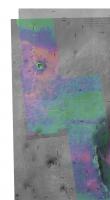
QUOTE (Tesheiner @ Apr 2 2010, 06:16 PM) Or the opposite maybe? I would like to see that topographic picture provided by tim53 overlayed on James' terrain analysis map; I have the impression that the "green" area fits more or less with the downslope part of the route and we may have a direct-hit from the wind there. ... That sounded like an interesting proposal to me, so here it is...Tim's topographic contours on top of James's ripple map. I was not able to perfectly register the two maps through any simple combination of rotation and/or scale changes; so this result is my manual, best average registration. It is good enough, however, to show that Eduardo's hunch was correct. Very good questions remain. Is the downslope region devoid of large ripples because the wind is stronger or weaker there? We know most of the ripples don't move in the current wind regime, but perhaps the trend is the same even in the current wind regimen.
-------------------- ...Tom
I'm not a Space Fan, I'm a Space Exploration Enthusiast. |
|
|
|
|
|
|
Apr 4 2010, 10:41 AM
Post
#28
|
|
|
Senior Member Group: Members Posts: 2918 Joined: 14-February 06 From: Very close to the Pyrénées Mountains (France) Member No.: 682 |
Looking it at a larger scale, it may be possible that the Endeavour ring, I mean the hills South East of the actual position could deflect the wind it the direction of the "green" area (this would mean that the dominant wind comes from the South East). It could also be the other way around: the eleavtion slowing down a dominant North West wind. Anyway, looking at CosmicRocker rendering, the ring elevation seams to have some effect.
-------------------- |
|
|
|
|
Apr 4 2010, 03:05 PM
Post
#29
|
||
|
Senior Member Group: Members Posts: 2998 Joined: 30-October 04 Member No.: 105 |
The ripples are changing because of an increase in wind velocity.
When we reached Concepcion we noticed the presence of transverse dunes (ripples), which suggested either an increase in sand availability or an increse in wind velocity. I initially thought of an increase in sand supply since there is a great deal of weathering of the fragmented rock around the fresh crater, but as we traveled southward ("upwind") of the crater, the transverse dunes were still present and by the time we got to the older, weathered San Antonio craters, we also started seeing scalloping of sand on the ripple crests (erosion). Concepcion was on the crest of a slight topographic high and the surface to San Antionio is essential flat or with a slight southward dip, and from the Tim Parker topo map, we see that the elevations decrease sharply to the south and southeast. Air moving in a laminar flow at altitude encounters the hillside and since the cross-sectional flow area is decreased, the velocity will increase due to a venturi effect. You can also see an increase in bare bedrock areas between here and "mini-Endurance", which I had hoped would be an indication of a change in lithology due to a drop in elevation, but, alas, appears to be less sand because of more wind... Attached is a drawing illustrating the orographic effect, adapted from an earlier topo x-section by fredk. --Bill
Attached thumbnail(s)
-------------------- |
|
|
|
|
|
|
Apr 4 2010, 03:41 PM
Post
#30
|
|
|
Senior Member Group: Members Posts: 2918 Joined: 14-February 06 From: Very close to the Pyrénées Mountains (France) Member No.: 682 |
Thank you Bill.
I was talking of a venturi effect due to the Endeavour rim. Is this consistent with your explanation or not necessary? Thanks -------------------- |
|
|
|
|

|
Lo-Fi Version | Time is now: 19th April 2024 - 04:01 AM |
|
RULES AND GUIDELINES Please read the Forum Rules and Guidelines before posting. IMAGE COPYRIGHT |
OPINIONS AND MODERATION Opinions expressed on UnmannedSpaceflight.com are those of the individual posters and do not necessarily reflect the opinions of UnmannedSpaceflight.com or The Planetary Society. The all-volunteer UnmannedSpaceflight.com moderation team is wholly independent of The Planetary Society. The Planetary Society has no influence over decisions made by the UnmannedSpaceflight.com moderators. |
SUPPORT THE FORUM Unmannedspaceflight.com is funded by the Planetary Society. Please consider supporting our work and many other projects by donating to the Society or becoming a member. |
|