MSL Images & Cameras, technical discussions of images, image processing and cameras |

  |
MSL Images & Cameras, technical discussions of images, image processing and cameras |
 Sep 12 2012, 09:10 PM Sep 12 2012, 09:10 PM
Post
#76
|
|
 Senior Member  Group: Members Posts: 4246 Joined: 17-January 05 Member No.: 152 |
Maybe software could use sparsely timed images (like Spirit's DD sequences) to detect a DD with software and then trigger high frame rate video (without motion detection). But I don't know if there's much we'd learn from DD video.
It may depend on what we see - if there are lots of DDs, we'll catch some by accident. |
 |
 
|
|
Sep 12 2012, 09:22 PM
Post
#77
|
|
|
Senior Member Group: Members Posts: 2511 Joined: 13-September 05 Member No.: 497 |
QUOTE (fredk @ Sep 12 2012, 02:10 PM)  Maybe software could use sparsely timed images (like Spirit's DD sequences) to detect a DD with software and then trigger high frame rate video (without motion detection). Certainly it's conceivable that we could run a Navcam sequence looking for dust devils, find one, slew the Mastcam to it and start a video acquisition. That capability doesn't exist right now, though, and I don't know if the science value would be worth the effort. -------------------- Disclaimer: This post is based on public information only. Any opinions are my own.
|
|
|
|
|
Sep 12 2012, 10:02 PM
Post
#78
|
|
 Martian Photographer Group: Members Posts: 352 Joined: 3-March 05 Member No.: 183 |
QUOTE (fredk @ Sep 12 2012, 09:10 PM) It may depend on what we see - if there are lots of DDs, we'll catch some by accident. Pathfinder, Spirit, Opportunity, and Phoenix returned their first images of dust devils serendipitously. All but Phoenix had dust devil campaigns prior to the first detection of a dust devil in an image, also. I would expect "exploratory" observations to have a different priority and implementation from "monitoring" observations. I think that with previous missions, the frequency of intentionally looking for dust devils vaguely correlates with the amount orbital evidence for dust devils in the area. M34 has some neat advantages over Navcam if you have reason to believe its FOV is sufficient--it would have been great up in the Columbia Hills--but Navcam's FOV is better for exploratory surveys, as with MER. Of course, exploration frequently follows many paths. |
|
|
|
|
Sep 13 2012, 11:50 AM
Post
#79
|
|
|
Senior Member Group: Members Posts: 2920 Joined: 14-February 06 From: Very close to the Pyrénées Mountains (France) Member No.: 682 |
I must admit there's something I don't understand.
I understood that, once the covers of the Hazcam have been removed, they were to kind of hanging somewhere (I mean not on the ground). Looking at the bellypan or whatever you call it, I can't see those covers. Any thoughts? -------------------- |
|
|
|
|
Sep 13 2012, 12:32 PM
Post
#80
|
|
 Senior Member Group: Members Posts: 3419 Joined: 9-February 04 From: Minneapolis, MN, USA Member No.: 15 |
QUOTE (climber @ Sep 13 2012, 06:50 AM) I understood that, once the covers of the Hazcam have been removed, they were to kind of hanging somewhere (I mean not on the ground). Looking at the bellypan or whatever you call it, I can't see those covers. Any thoughts? If you look closely at the bellypan, underneath and offset from each of the hazcam lenses there is a spring. We know that the hazcam lens covers were designed for a one-time deployment; the springs were supposed to move them completely out of the way of the lenses, for good. My guess is that the lens covers are out of sight on the bottom of the lens housing, one each attached to each spring visible in the MAHLI images. -the other Doug -------------------- The trouble ain't that there is too many fools, but that the lightning ain't distributed right. -Mark Twain
|
|
|
|
|
Sep 13 2012, 12:38 PM
Post
#81
|
|
|
Member Group: Members Posts: 153 Joined: 4-May 11 From: Pardubice, CZ Member No.: 5979 |
QUOTE (climber @ Sep 13 2012, 01:50 PM) I must admit there's something I don't understand. I understood that, once the covers of the Hazcam have been removed, they were to kind of hanging somewhere (I mean not on the ground). Looking at the bellypan or whatever you call it, I can't see those covers. Any thoughts? This video explains it all : http://mars.jpl.nasa.gov/msl/multimedia/vi.../index.cfm?v=53 |
|
|
|
|
Sep 13 2012, 12:50 PM
Post
#82
|
||
|
Senior Member Group: Moderator Posts: 4279 Joined: 19-April 05 From: .br at .es Member No.: 253 |
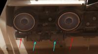
There were several posts about this topic on the landing or pre-landing thread.
You can see the springs (cyan arrows) and the covers (red arrows) on this crop image.
|
|
|
|
|
|
|
Sep 13 2012, 01:00 PM
Post
#83
|
|
 Senior Member Group: Members Posts: 2173 Joined: 28-December 04 From: Florida, USA Member No.: 132 |
QUOTE (pospa @ Sep 13 2012, 07:38 AM) This video explains it all : http://mars.jpl.nasa.gov/msl/multimedia/vi.../index.cfm?v=53 Rotating the video image shows how the cover may be hidden behind the spring.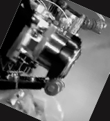
|
|
|
|
|
Sep 13 2012, 01:52 PM
Post
#84
|
|
|
Senior Member Group: Members Posts: 2920 Joined: 14-February 06 From: Very close to the Pyrénées Mountains (France) Member No.: 682 |
Thank you ALL!
Believe me, I read ALL posts but can't remember understanding where they'll end up. Yes, spings are very evident to me for sure and I though covers have to be somewhere but I couldn't see them. Video also helps. -------------------- |
|
|
|
|
Sep 15 2012, 04:06 PM
Post
#85
|
|
 Senior Member Group: Moderator Posts: 3431 Joined: 11-August 04 From: USA Member No.: 98 |
QUOTE (fredk @ Sep 15 2012, 08:56 AM) But all of the smudginess is artifacts - the sun should be very smooth. I've noticed that they're really compressing the living daylights out of MSL images before putting them on the web - much more so than the MER images are compressed. Or are we talking about a different kind of artifacting. |
|
|
|
|
Sep 15 2012, 04:26 PM
Post
#86
|
|
 Member Group: Members Posts: 112 Joined: 20-August 12 From: Spain Member No.: 6597 |
I think the main problem behind the most artifacts is JPEG compression. I think they should try PNG or a less agressive compression scheme.
QUOTE (mhoward @ Sep 15 2012, 04:06 PM) I've noticed that they're really compressing the living daylights out of MSL images before putting them on the web - much more so than the MER images are compressed. Or are we talking about a different kind of artifacting. |
|
|
|
|
Sep 15 2012, 05:14 PM
Post
#87
|
|
|
Senior Member Group: Members Posts: 4246 Joined: 17-January 05 Member No.: 152 |
The problem with the sun image is that the public images are lossless -> jpeg rather than lossless -> debayer -> jpeg or just lossless. That's the same problem that gives the green splotches on landscape shots.
QUOTE (mhoward @ Sep 15 2012, 04:06 PM) they're really compressing the living daylights out of MSL images before putting them on the web - much more so than the MER images are compressed. I haven't noticed that - could you give an example of that? Or did you mean the bayering problem?
|
|
|
|
|
Sep 15 2012, 05:29 PM
Post
#88
|
|
|
Senior Member Group: Members Posts: 2511 Joined: 13-September 05 Member No.: 497 |
QUOTE (mhoward @ Sep 15 2012, 09:06 AM) I've noticed that they're really compressing the living daylights out of MSL images before putting them on the web... I think they're just using a fixed quality (75, maybe?). Of course it doesn't help that there is sometimes a decompress/recompress and that they JPEG-compress Bayer-pattern data. The final compression ratio seems to be around 8:1 to 9:1. Are the MER images really a lot lower compression ratio? For the 100mm sun image, since the filter cuts out all of the pixels besides blue anyway, you'd be better off just tossing the other Bayer positions and then upsampling as desired. But it's still going to be a round slightly-fuzzy circle with a bite out of one side. -------------------- Disclaimer: This post is based on public information only. Any opinions are my own.
|
|
|
|
|
Sep 15 2012, 05:35 PM
Post
#89
|
|
 Senior Member Group: Members Posts: 3648 Joined: 1-October 05 From: Croatia Member No.: 523 |
QUOTE (mcaplinger @ Sep 15 2012, 07:29 PM) Of course it doesn't help that there is sometimes a decompress/recompress I though the cameras basically return JPEG compliant data so that there shouldn't be a need to decompress/recompress the stream again. Are they really doing that for color images? -------------------- |
|
|
|
|
Sep 15 2012, 06:03 PM
Post
#90
|
|
|
Senior Member Group: Members Posts: 2511 Joined: 13-September 05 Member No.: 497 |
QUOTE (ugordan @ Sep 15 2012, 10:35 AM) I though the cameras basically return JPEG compliant data so that there shouldn't be a need to decompress/recompress the stream again. Are they really doing that for color images? http://pds.nasa.gov/tools/policy/ExplicitP...tsStatement.pdf QUOTE PDS Archives must comply with the following All EDR image data delivered for archiving must consist of simple raster images with PDS labels Now, you could claim that this doesn't have to apply to public release images and I wouldn't argue with you, but it would require delivery in two forms unless there was a decompress/recompress cycle. -------------------- Disclaimer: This post is based on public information only. Any opinions are my own.
|
|
|
|
|

|
Lo-Fi Version | Time is now: 30th April 2024 - 12:08 AM |
|
RULES AND GUIDELINES Please read the Forum Rules and Guidelines before posting. IMAGE COPYRIGHT |
OPINIONS AND MODERATION Opinions expressed on UnmannedSpaceflight.com are those of the individual posters and do not necessarily reflect the opinions of UnmannedSpaceflight.com or The Planetary Society. The all-volunteer UnmannedSpaceflight.com moderation team is wholly independent of The Planetary Society. The Planetary Society has no influence over decisions made by the UnmannedSpaceflight.com moderators. |
SUPPORT THE FORUM Unmannedspaceflight.com is funded by the Planetary Society. Please consider supporting our work and many other projects by donating to the Society or becoming a member. |
|