Cape York - Shoemaker Ridge and the NE traverse, Starting sol 2735 |

  |
Cape York - Shoemaker Ridge and the NE traverse, Starting sol 2735 |
 Oct 26 2011, 01:08 AM Oct 26 2011, 01:08 AM
Post
#241
|
|
|
Junior Member  Group: Members Posts: 54 Joined: 10-August 11 Member No.: 6119 |
QUOTE (fredk @ Oct 26 2011, 01:23 AM)  But I use stereophoto maker (for viewing and creating my anaglyphs). Thanks for the link, that's a great bit of software. |
 |
 
|
|
Oct 26 2011, 05:39 PM
Post
#242
|
|
|
Senior Member Group: Members Posts: 2998 Joined: 30-October 04 Member No.: 105 |
There are now images of the following sites on Shoemaker Ridge at my photo website (URL in signature):
Sol- 02749 p2414 Onverwacht 02753 p2418 Havelock 02751 p2560. Hooggenoeg 02751 p2561 Tjakastad 02753 p2564 Fairview current pancam_foreground_quarter images --Bill -------------------- |
|
|
|
|
Oct 26 2011, 07:41 PM
Post
#243
|
|
 Member Group: Members Posts: 714 Joined: 3-January 08 Member No.: 3995 |
.
|
|
|
|
|
Oct 26 2011, 08:45 PM
Post
#244
|
|
 Member Group: Members Posts: 404 Joined: 5-January 10 Member No.: 5161 |
QUOTE (Gladstoner @ Oct 26 2011, 11:41 AM) ...but it is more natural than the brutal cross-eyed method.  Totally agree. The parallel method might take a little more practice, but it's pure relaxation compared to the cross-eyed method! |
|
|
|
|
Oct 26 2011, 11:12 PM
Post
#245
|
|
|
Member Group: Members Posts: 866 Joined: 15-March 05 From: Santa Cruz, CA Member No.: 196 |
thanks, i tried and got it to work (yes, by *not* trying as Alan Watts would say), and is far easier on the eyes!
The only drawback is that i cant make the image pair much larger than the natural distance beteen my eyes as measured across the computer screen, but for smaller sizes it works great. thanks again for the tip! For anyone who wants to get started here are some tips: 1) Try this image pair in the post by mhoward. 2) shrink the resltant window to about half size or smaller, the smaller the easier it is get inital focus. 3) look in a very relaxed way at the center so that in this example the white rock in the bottom of the two images suddenly 'snap' together as one, then hold the line! 4) gradually drag the window size larger as large as possible, eventually the stereo effect deteriorates and you lose focus as the distance beteen the focal point for each eye one the screen starts to exceed your interocular distance. As a bonus, you can also parellelify anaglyphs using the excellent Stereo Photo Maker previously referred to. Take some of the fine anaglyphs generous folks have posted to UMSF such as Walfy's oppy trails and open as anaglyph, then change to side by side and swap sides, shrink and view! |
|
|
|
|
Oct 27 2011, 02:45 AM
Post
#246
|
|
|
Member Group: Members Posts: 808 Joined: 10-October 06 From: Maynard Mass USA Member No.: 1241 |
This is one of the best NavCam shots ever taken by Oppy (... IMHO
 ... ) ... )Sol 2756. Its a little after 2 o'clock in the afternoon on a far away planet http://qt.exploratorium.edu/mars/opportuni...V5P1897L0M1.JPG -------------------- CLA CLL
|
|
|
|
|
Oct 27 2011, 04:48 AM
Post
#247
|
||
|
Member Group: Members Posts: 404 Joined: 5-January 10 Member No.: 5161 |
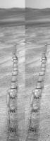
QUOTE (PDP8E @ Oct 26 2011, 06:45 PM) ...one of the best NavCam shots ever taken by Oppy... Here's a slice of that shot for viewing in parallel, not cross-eyed. It's narrow so it can be viewed without special equipment. Still not as spectacular as the original. Unfortunately, this method for 3D viewing without equipment is limited to narrow slices of images in the vertical. It still can be lots of fun.
|
|
|
|
|
|
|
Oct 27 2011, 05:04 AM
Post
#248
|
||
|
Junior Member Group: Members Posts: 59 Joined: 18-July 07 From: London, UK Member No.: 2873 |
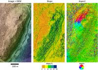
I've been meaning to do this for a while, but was inspired by being lucky enough to meet Jim Bell this week, and look at some recent anaglyphs with him. So, here's my take on the topography of Cape York from my HiRISE DEM (still getting some mileage out of this thing!), showing the slope and the aspect.
So because Oppy needs a north-facing slope, you can really see here why they're heading towards the top of Cape York. I'm sure others can pick out some of the possible best areas better than my jetlag will allow. Pete |
|
|
|
|
|
|
Oct 27 2011, 05:28 AM
Post
#249
|
|
 Senior Member Group: Members Posts: 2228 Joined: 1-December 04 From: Marble Falls, Texas, USA Member No.: 116 |
Very nice.
Thank you.
-------------------- ...Tom
I'm not a Space Fan, I'm a Space Exploration Enthusiast. |
|
|
|
|
Oct 27 2011, 10:29 AM
Post
#250
|
|
 Member Group: Members Posts: 593 Joined: 20-April 05 Member No.: 279 |
Love that data, Pete.
Is there any chance you could combine the slope and aspect results? Maybe run this: angle = ACOS((sin(slope)*cos(aspect)*sin(sol))+(cos(slope)*cos(sol))) Where: slope is measured in radians aspect in radians from north, going clockwise sol is 0.576 in radians (90-57 degrees, from the axial tilt and rover latitude) ...to produce a range of angles from 0 to PI to determine the best (angle = 0) attitude for the rover's panels based on slope and aspect for the midwinter noon. Andy EDIT: sol is 0.471 in radians (27 degrees - being the winter axial tilt and rover's latitude of 2 degrees south). Thanks Fred! |
|
|
|
|
Oct 27 2011, 12:01 PM
Post
#251
|
|
|
Senior Member Group: Members Posts: 3516 Joined: 4-November 05 From: North Wales Member No.: 542 |
Great maps! I'm a little puzzled by the slope one though. It seems to show no areas with 0-5 degrees slope, whereas there must be such places, e.g. on the summit of CY and on the saddle joining it to the plains. Is the colour key all shifted by one colour perhaps?
|
|
|
|
|
Oct 27 2011, 02:33 PM
Post
#252
|
||
|
Junior Member Group: Members Posts: 59 Joined: 18-July 07 From: London, UK Member No.: 2873 |
Ah, the perils of posting on UMSF when jetlagged - there are lots of eagle-eyed people out there! Thanks for spotting that mistake on the slope map label, I made it myself and got my numbers wrong, apologies. There are of course quite a few slopes that are between 0 and 5 degrees. It should be something more like this:
Combining the slope and aspect is a great idea, and I'll give it a go when I get chance. Pete |
|
|
|
|
|
|
Oct 27 2011, 02:52 PM
Post
#253
|
||
 The Poet Dude Group: Moderator Posts: 5551 Joined: 15-March 04 From: Kendal, Cumbria, UK Member No.: 60 |
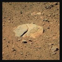
"New Consort"...
I love staring into these surface close-up images and picking out all the different shaped/hued chips and shards of stone...
-------------------- |
|
|
|
|
|
|
Oct 27 2011, 03:06 PM
Post
#254
|
|
 Member Group: Members Posts: 267 Joined: 5-February 06 Member No.: 675 |
QUOTE (AndyG @ Oct 27 2011, 05:29 AM) Love that data, Pete. Is there any chance you could combine the slope and aspect results? Second Andy's thanks for the excellent presentation, but agree with him on the desirability of combining slope and aspect data. My choice would be to keep your hue based aspect information, but encode the slope as saturation, with increasing slope indicated by increased saturation. It would provide a fairly intuitive presentation. Can anyone suggest an easy way to do that? SteveM |
|
|
|
|
Oct 27 2011, 03:43 PM
Post
#255
|
|
 Senior Member Group: Moderator Posts: 3431 Joined: 11-August 04 From: USA Member No.: 98 |
|
|
|
|
|

|
Lo-Fi Version | Time is now: 19th April 2024 - 10:30 PM |
|
RULES AND GUIDELINES Please read the Forum Rules and Guidelines before posting. IMAGE COPYRIGHT |
OPINIONS AND MODERATION Opinions expressed on UnmannedSpaceflight.com are those of the individual posters and do not necessarily reflect the opinions of UnmannedSpaceflight.com or The Planetary Society. The all-volunteer UnmannedSpaceflight.com moderation team is wholly independent of The Planetary Society. The Planetary Society has no influence over decisions made by the UnmannedSpaceflight.com moderators. |
SUPPORT THE FORUM Unmannedspaceflight.com is funded by the Planetary Society. Please consider supporting our work and many other projects by donating to the Society or becoming a member. |
|