March 15, 2010 PDS release |

  |
March 15, 2010 PDS release |
 Mar 16 2010, 01:23 AM Mar 16 2010, 01:23 AM
Post
#16
|
|
|
Solar System Cartographer  Group: Members Posts: 10146 Joined: 5-April 05 From: Canada Member No.: 227 |
I bet you say that to all the cartographers!
Phil -------------------- ... because the Solar System ain't gonna map itself.
Also to be found posting similar content on https://mastodon.social/@PhilStooke NOTE: everything created by me which I post on UMSF is considered to be in the public domain (NOT CC, public domain) |
 |
 
|
|
Mar 16 2010, 03:07 AM
Post
#17
|
||
|
Junior Member Group: Members Posts: 23 Joined: 6-November 09 Member No.: 5017 |
QUOTE (zeBeamer @ Mar 15 2010, 05:17 PM)  Rick, glad the JP2s are working for you (they are all unsigned INT16). But the IMGs are there as well, just in case! I just kicked out a couple of Terragen pix of Copernicus; the LDEM64 in JP2000 seems to have some striping, but I've seen that in MOLA files as well and I suspect that will get cleared up in time. I'll try running the .img through MacDEM and see what happens. Exciting times; I'm already looking into an 8" to 12" physical sphere with full relief, as well as some selected regions for rapid prototyping. - Rick
|
|
|
|
|
|
|
Mar 16 2010, 03:11 AM
Post
#18
|
|
|
Junior Member Group: Members Posts: 22 Joined: 20-June 09 Member No.: 4830 |
Nice rendering
 Yes, orbit improvement is ongoing... Hopefully next release some of those orbital track artifacts will be gone! |
|
|
|
|
Mar 16 2010, 03:59 AM
Post
#19
|
|
|
Solar System Cartographer Group: Members Posts: 10146 Joined: 5-April 05 From: Canada Member No.: 227 |
The Lunokhod 2 tracks are also clearly visible pretty much all the way from the hills south of the landing area to the end of the route, but the landing area in the image I looked at is not very obvious.
I have looked at the area I have been promoting for Lunokhod 1. It seems I was wrong! But the true location has not appeared yet. Phil -------------------- ... because the Solar System ain't gonna map itself.
Also to be found posting similar content on https://mastodon.social/@PhilStooke NOTE: everything created by me which I post on UMSF is considered to be in the public domain (NOT CC, public domain) |
|
|
|
|
Mar 16 2010, 04:15 AM
Post
#20
|
||
|
Junior Member Group: Members Posts: 23 Joined: 6-November 09 Member No.: 5017 |
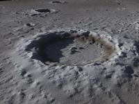
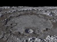
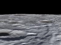
QUOTE (zeBeamer @ Mar 15 2010, 07:11 PM) Nice rendering Yes, orbit improvement is ongoing... Hopefully next release some of those orbital track artifacts will be gone! Thanks. Not meaning to hog the thread, but here's a quick view of Orientale with a generic moon-ish texture. *Much* more experimentation in the coming weeks. - Rick
|
|
|
|
|
|
|
Mar 16 2010, 04:21 AM
Post
#21
|
|
|
Merciless Robot Group: Admin Posts: 8783 Joined: 8-December 05 From: Los Angeles Member No.: 602 |
Emily wrote up a nice blog post with Phil's discovery, along with pics of Lunas 20, 23 & 24.
-------------------- A few will take this knowledge and use this power of a dream realized as a force for change, an impetus for further discovery to make less ancient dreams real.
|
|
|
|
|
Mar 16 2010, 04:40 AM
Post
#22
|
|
 Administrator Group: Admin Posts: 5172 Joined: 4-August 05 From: Pasadena, CA, USA, Earth Member No.: 454 |
I had the most frustrating day imaginable today, shuffling five ongoing projects and an insomniac baby, completing nothing; one of the projects is a lengthy blog post attempting to explain to all you folks who are not Phil how to dive headfirst into PDS volumes -- I really really will try to finish that one tomorrow. Anyway, after finally getting the kids to bed after the long, frustrating day I sat down at my computer and I was like, "For God's sake, why did they have to release those images at 5 pm Pacific after a day like today!?" I was darned if I was going to be the last space blogger to write about the Lunas and Lunokhod, which is what would have happened if I hadn't sat down to write tonight! Phil, I hope it was OK to fold in to the blog post what I know is a preliminary browse view from something I know you are working very hard on doing in much better quality.
-------------------- My website - My Patreon - @elakdawalla on Twitter - Please support unmannedspaceflight.com by donating here.
|
|
|
|
|
Mar 16 2010, 05:45 AM
Post
#23
|
||||
 Senior Member Group: Moderator Posts: 3231 Joined: 11-February 04 From: Tucson, AZ Member No.: 23 |
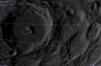
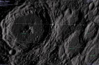
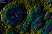
QUOTE (zeBeamer @ Mar 15 2010, 05:19 PM) Second, we are releasing ready-made textures for Celestia. Many of you know Celestia (shatters.net/celestia), and some of you produced normal maps from the Kaguya altimetry data. In addition to a LOLA normal map, a texture showing the topography in false-color was made. location: http://imbrium.mit.edu/EXTRAS/CELESTIA/ Thanks very much for doing this! Here is a comparison between the LOLA normal map and the Kaguya map:
Already an improvement 
-------------------- &@^^!% Jim! I'm a geologist, not a physicist!
The Gish Bar Times - A Blog all about Jupiter's Moon Io |
|||
|
|
|
|||
|
Mar 16 2010, 06:15 AM
Post
#24
|
|
 The Poet Dude Group: Moderator Posts: 5551 Joined: 15-March 04 From: Kendal, Cumbria, UK Member No.: 60 |
QUOTE (Rick Sternbach @ Mar 16 2010, 04:15 AM) Not meaning to hog the thread, but here's a quick view of Orientale with a generic moon-ish texture. Hog away, Rick, lovely stuff! Very Chesley Bonestellian that Orientale view... -------------------- |
|
|
|
|
Mar 16 2010, 06:26 AM
Post
#25
|
|
|
Senior Member Group: Members Posts: 2078 Joined: 13-February 10 From: Ontario Member No.: 5221 |
Is there a thread somewhere about the new photos of the old Soviet landers/rovers? I don't see one, and am vary of making a new thread on them....
|
|
|
|
|
Mar 16 2010, 07:24 AM
Post
#26
|
|
|
Founder Group: Chairman Posts: 14431 Joined: 8-February 04 Member No.: 1 |
You didn't look very hard. Just two threads below this one, in the very same sub forum, a thread that explicitly mentions those missions in it's subheading.
http://www.unmannedspaceflight.com/index.php?showtopic=6192 |
|
|
|
|
Mar 16 2010, 05:20 PM
Post
#27
|
||
|
Junior Member Group: Members Posts: 23 Joined: 6-November 09 Member No.: 5017 |
QUOTE (Stu @ Mar 15 2010, 10:15 PM) Hog away, Rick, lovely stuff! Very Chesley Bonestellian that Orientale view... Okay, here's a shot of the highlands. I grabbed some part of a 45 degree north file and rendered away; I'll get better at describing exact features later on. I've looked through the LOLA files over at imbrium.mit.edu, and now see how they're organized, I think. They offer the whole moon unwrapped as a cylindrical map at 4, 16, and 64 pixels per degree, in JPEG2000, .IMG, .GRD formats. Personally, I have no idea how to use the .GRD, so I'm sticking to the JPEG2000 and .IMG files. They have: 45 degrees north and south at (I believe) 100 meters/pixel, 200m/px, 400m/px in the same formats. 60 degrees north and south at 120m/px, 240m/px 75 degrees north and south at 30m/px, 60m/px, 120m/px 80 degrees north and south at 20m/px, 40m/px, 80m/px 85 degrees north and south at 10m/px, 20m/px, 40m/px 87.5 degrees north and south at 5m/px, 10m/px, 20m/px 5 meters per pixel must be pretty darned detailed, and the file size gets huge, like 3.4GB for the .GRD file. The 45N file that I opened seems to have the craters looking correctly circular; I'll try opening a higher latitude file to see if they correct the geometry all the way up. I'm going to assume that with more orbits and more laser points recorded, the density of detail will just keep going up, as will the file size. I need a new computer.
|
|
|
|
|
|
|
Mar 16 2010, 06:30 PM
Post
#28
|
|
|
Junior Member Group: Members Posts: 94 Joined: 15-October 09 Member No.: 4979 |
Nuts...
finally got IMG2PNG to work, and had thought this would be the calibrated NAC data... unfortunately it doesn't appear to be :-( |
|
|
|
|
Mar 16 2010, 06:35 PM
Post
#29
|
|
|
Senior Member Group: Moderator Posts: 3231 Joined: 11-February 04 From: Tucson, AZ Member No.: 23 |
Most data submitted to the PDS for most missions will be uncalibrated, raw data. The best way to ingest LROC data, get them calibrated, reproject them, etc., is to use ISIS3. http://isis.astrogeology.usgs.gov/Applicat...issance_Orbiter lists the LROC specific programs in ISIS3, so it looks like the LROC folks use ISIS3 extensively like the HiRISE people do. If someone can post the links to the specific Luna mission images, I might be able to give them a try tomorrow, but I am not as familiar with ISIS3 as I am with ISIS2, which I use for Cassini ISS images (though I did use ISIS3 for MESSENGER).
-------------------- &@^^!% Jim! I'm a geologist, not a physicist!
The Gish Bar Times - A Blog all about Jupiter's Moon Io |
|
|
|
|
Mar 16 2010, 06:49 PM
Post
#30
|
|
|
Junior Member Group: Members Posts: 94 Joined: 15-October 09 Member No.: 4979 |
Thanks Pele!
|
|
|
|
|

|
Lo-Fi Version | Time is now: 18th April 2024 - 11:36 PM |
|
RULES AND GUIDELINES Please read the Forum Rules and Guidelines before posting. IMAGE COPYRIGHT |
OPINIONS AND MODERATION Opinions expressed on UnmannedSpaceflight.com are those of the individual posters and do not necessarily reflect the opinions of UnmannedSpaceflight.com or The Planetary Society. The all-volunteer UnmannedSpaceflight.com moderation team is wholly independent of The Planetary Society. The Planetary Society has no influence over decisions made by the UnmannedSpaceflight.com moderators. |
SUPPORT THE FORUM Unmannedspaceflight.com is funded by the Planetary Society. Please consider supporting our work and many other projects by donating to the Society or becoming a member. |
|