Printable Version of Topic
Click here to view this topic in its original format
Unmanned Spaceflight.com _ MSL _ MSL Post First Drive - Intermission, Start of Drive to Glenelg
Posted by: elakdawalla Aug 23 2012, 02:39 PM
Curiosity's Cap 1B phase was completed yesterday with the successful first drive, so now we're going into "Intermission." http://www.planetary.org/blogs/guest-blogs/20120822-limonadi-sampling-mars-4-commissioning.html has great explanations of what all these phases mean.
Posted by: elakdawalla Aug 23 2012, 08:03 PM
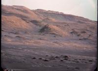
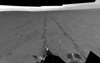
First sol 17 Navcam thumbnails are up on the raws page -- more views of Mt Sharp.
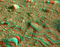
Posted by: fredk Aug 24 2012, 07:40 PM
Could someone please de-Bayer this:
http://mars.jpl.nasa.gov/msl-raw-images/msss/00017/mcam/0017MR0050002000C0_DXXX.jpg
And pass the swear jar! 
Posted by: Ant103 Aug 24 2012, 07:53 PM
With pleasure 
http://www.db-prods.net/marsroversimages/Curiosity/2012/0017MR0050002000C0_DXXX_unbayered.png
And with a bit more levels :
http://www.db-prods.net/marsroversimages/Curiosity/2012/0017MR0050002000C0_DXXX_unbayered_stretched.png
The details are
I have no words for now 
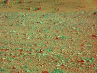
Posted by: Fred B Aug 24 2012, 07:54 PM

Here's my attempt at debayering. I cooked it pretty hard to see how much detail I could get out. The patches of green and purple are not real, those come from JPEG artifacts in the source images.
|
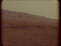
Posted by: elakdawalla Aug 24 2012, 08:07 PM
Looks like a vintage postcard Really stunning.
Look at the little sand drifts in the near horizon on this one! http://mars.jpl.nasa.gov/msl-raw-images/msss/00017/mcam/0017ML0050003000C0_DXXX.jpg
Posted by: Ant103 Aug 24 2012, 08:24 PM
Yes Emily. And I'm wondering if Curiosity's team is planning to open an Instagram account to the rover .
This view, in color :
http://www.db-prods.net/marsroversimages/Curiosity/2012/0017ML0050003000C0_DXXX_unbayered.png
Posted by: Phil Stooke Aug 24 2012, 08:27 PM
These are amazing pictures... Fred B - absolutely stunning! It's going to be incredible driving around that topography.
But first - Glenelg. I hope we'll see another drive soon. I will be posting route maps from time to time, but not after every drive. In particular I'm not able to do so from Aug. 31st to Sept. 16th, but look for something after that.
Phil
Posted by: akuo Aug 24 2012, 08:28 PM
Wow, I think we can see there is nothing wrong with the focus of Mastcam100. Those lossless frames are really something, too bad they are not released losslessly.
Posted by: eoincampbell Aug 24 2012, 11:34 PM
 Lovely description, brilliant results!
Posted by: Phil Stooke Aug 25 2012, 07:18 AM
A drive was planned for 23rd but postponed (Paolo via Twitter) - maybe tosol?
Phil
Posted by: paraisosdelsistemasolar Aug 25 2012, 10:36 AM
Hi to everybody,
This is my first try at converting the color information on the right MastCam images. Altough is not as good as I would like (don't know if it's due to JPEG compression or because I don't know how to do it better) it clearly shows the color of the soil and the rocks. The ventifacts are pretty nice 
|
Comments and advice are welcome!
Greetings!
Posted by: jmknapp Aug 25 2012, 10:59 AM
That looks like the best yet!
So what is the deal with the bayered images? Some mastcam images are de-bayered on Mars (or back home) and some are not? The algorithm for Mars scenes should be easy--just assume a shade of red & you're good.
Sure would be nice if Adobe Lightroom had a "MASTCAM RAW" plugin. Of course, jpegging them beforehand is sub-optimal.
Posted by: RoverDriver Aug 25 2012, 11:53 AM
Phil
Sol 21, but things might change (again).
Paolo
Posted by: ugordan Aug 25 2012, 11:56 AM
The ones that are returned in original, Bayered form are lossless which is A Good Thing.
Posted by: paraisosdelsistemasolar Aug 25 2012, 01:33 PM
Every new frame is a surprise for me. With the new raw frames from right MastCam downloaded some minutes before... we have a vertical panorama!
|
|
This is the little version. If you want to see the full version of the panorama, go to: http://www.ungeologoenapuros.es/wp-content/uploads/2012/08/0017MR0050000000C0_DXXX-Panorama.jpg It's 8 MB.
Comments and suggestions are welcome!
Posted by: Ant103 Aug 25 2012, 01:33 PM
An other unbayered image.
http://www.db-prods.net/marsroversimages/Curiosity/2012/0017MR0050033000C0_DXXX_unb.jpg
There is not only Photoshop in image processing life, I'm actually using ImageJ with the "debayer" plugin, http://umanitoba.ca/faculties/science/astronomy/jwest/plugins.html (scroll down). Then, in ImageJ set the image in 16bit mode. Then, go to "plugin>debayer" (you should have install it in the correct folder in order to have it in your plugin list). The best method is "R-G-R-G", set Demosaicing Algorithm to "Adaptive Smooth Hue" (I think it gives the best results). Checkbox "Display color image". Et voilà ! Save or do whatever you want with your debayered image .
Posted by: john_s Aug 25 2012, 01:58 PM
Great images, especially the vertical panorama!
I'm puzzled why we are still seeing hue quantization in these de-Bayered images, as we did in the color JPEGs. Why would JPEG compression of the Bayer pattern produce that effect, rather than just randomly perturbing the colors?
John
Posted by: ugordan Aug 25 2012, 02:18 PM
Since the checkerboard bright/dark appearance of the Bayer pattern in grayscale depends on the original color of the scene, various blocks can end up having different DCT frequency domain component breakdowns, but not all frequency components are quantized equally. This, I think affects the amount of pixel crosstalk. If one overlays a Bayered image over a color one, one can see the places that experience color shfts have a distinctly different checkerboard pattern feel to them. Not completely the same mechanism as banding in highly compressed color images, but I guess you can say the root cause is the same.
I like this M-100 shot:
|
Posted by: paraisosdelsistemasolar Aug 25 2012, 02:51 PM
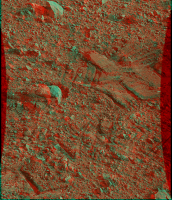
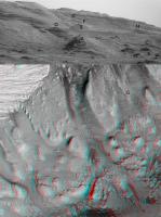
It's even possible to achieve a good, but not perfect, combination of MastCam left and right to make some anaglyphs, but the resolution is not as good as it could be due to the difference of angle of vision.
|
|
|
Posted by: Tesheiner Aug 25 2012, 03:35 PM
That's beautiful.
I really think the right 100mm camera won't stop providing us stunning shots.
Posted by: elakdawalla Aug 25 2012, 04:02 PM
That vertical panorama is terrific.
I have no sense of how large the pebbles are in the foreground -- I think they may be quite tiny. We need the Mystery Man -- and maybe the Mystery Man needs a Mystery Mouse companion to show us the size of those pebbles!
There are some cleat-marks in the soil midway down. What's the cleat-to-cleat distance on a MSL wheel?
Posted by: climber Aug 25 2012, 04:24 PM
Also interesting to note one rock sinkage after been roved over
Posted by: Ant103 Aug 25 2012, 04:24 PM
Yes, great work Parai'
My own version (full res available by clicking the image) :
http://www.db-prods.net/marsroversimages/curiosity.html#sol17
And there is also a M34 pan, incomplete for now, I think.
The M100 vertical pan is pretty large in vertical. Imagine now a full 360° acqured with this camera. No, my computer will die way a lot before finishing stitching only a half of the pano. A quick math :
The last M34 pan was 29 006 px wide for 3635 height. This column from M100 is 14 799 px, so about 14 800 px. A little cross product :
29 006 => x
3 635 => 14 800
y => 29 006 × 14 800 / 3 635
y => 118 098
So, this will result in a panoramic of about 118 000 pixels wide !! This is HUGE ! Is there computer which can just open such a huge picture ?  I pass my hand
Posted by: NickF Aug 25 2012, 04:32 PM
Thanks for that great deBayering tip Ant103! Here's a very simple stitch in the meantime.
|
Posted by: Stu Aug 25 2012, 05:08 PM
Well, well, well... turns out Registax has a DeBayer function...
|
Now all I have to do is work out how to get rid of the terraformed hills, and the handfuls of emeralds scattered over the ground...
Posted by: Reckless Aug 25 2012, 05:23 PM
In reply to Emily's question judging by this NASA JPL image the Zig-Zag cleats look about 5 cm apart.
Roy
|
Posted by: djellison Aug 25 2012, 05:31 PM
I pass my hand
Easy - just host it at the Gigapan website
Posted by: RoverDriver Aug 25 2012, 05:59 PM
What's the cleat-to-cleat distance on a MSL wheel?
The grousers are 15 deg apart, therefore the distance is about 6.5cm.
Paolo
Posted by: stewjack Aug 25 2012, 06:27 PM
Here is my attempt at an anaglyph using ANT103's work and just playing around with StereoPhotoMaker. I just warped the hell out of those graphics. I see 3d but my eyes tell me they are being twisted in there sockets!
|
Note: It is possible that I used a medium resolution version of ANT 103's MastCam100's Graphic! The resolution could be much worse than it should be. I just clicked on the images and copied them to my clipboard. Then pasted them into IrfanView.
Posted by: Phil Stooke Aug 25 2012, 07:18 PM
I would expect that most panoramas will be just the 34 camera, and the 100 camera will mostly be used for limited areas. But regardless of how they are used, what amazing cameras we have on this machine! Now let's see some micro-images...
Phil
Posted by: NickF Aug 25 2012, 08:47 PM
Another deBayered stitch.
|
Posted by: Phil Stooke Aug 25 2012, 09:40 PM
Matt Heverly tweets that the next drive is tomorrow after a quick detour to one of the scour marks to make an observation (Chemcam, presumably) before driving east.
Phil
Posted by: RoverDriver Aug 25 2012, 10:19 PM
We will be placing DAN on top of the northern scour mark.
Paolo
Posted by: fredk Aug 26 2012, 12:12 AM
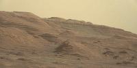
My best shot at a greyscale of the mastcam 100 view of the mound. I took the two slightly-different pointing frames, applied my Fourier filter to remove the jpeg Bayer artifacts as well as I could, de-Beyered, then averaged the two frames to remove even more residual jpeg artifacts, finally a contrast stretch. In the end, I think most of these details are real!
|
Just think: that's where we're going!
Posted by: jmknapp Aug 26 2012, 12:48 AM
Another try at a mastcam anaglyph. Here's a smaller version of the http://mars.jpl.nasa.gov/msl-raw-images/msss/00017/mcam/0017ML0050005000C0_DXXX.jpg image with the http://mars.jpl.nasa.gov/msl-raw-images/msss/00017/mcam/0017MR0050005000C0_DXXX.jpg area shown by the rectangle:
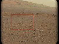
|
The anaglyph:
|
Posted by: Ant103 Aug 26 2012, 01:42 AM
Fredk : I've took your fantastic image and applied some wavelett sharpen. And then add color from one of my debayerized pics. Hope it's okay
|
Posted by: nprev Aug 26 2012, 01:58 AM
Uh...oh, my!
Wow.
The layering blows my mind.
Posted by: stewjack Aug 26 2012, 03:18 AM
This should probably be in the Making anaglyph images, Methods and software thread but my question is did you have any further adjustments in size after cropping out the image from the larger MR area? I did somewhat the same thing*, but the objects in the ML image still appeared much smaller. It looked really weird until I started playing with something called barrel distortion in StereoPhotoMaker. I don't claim to know what I am doing but if I try enough things sometimes something works. If I don't need to correct for barrel distortion that would certainly make things simpler.
* I didn't even use the full ML graphic.
I finally got this. ( click below ) Comparing mine to yours - yours certainly looks cleaner. However; mine may have more 3d effect in the fore & middle ground? Yes? No? Maybe?
click link:
http://www.unmannedspaceflight.com/index.php?act=attach&type=post&id=27692
http://www.unmannedspaceflight.com/index.php?showtopic=7426&view=findpost&p=189878
Jack
Posted by: dvandorn Aug 26 2012, 03:23 AM
Fred -- if someone showed me your b&w image in almost any other context and asked me where the picture was taken, I'd probably say somewhere in the canyon regions of the American Southwest.
I'm with Nick -- absolutely blown away.
This is gonna be *fun*, guys.... 
-the other Doug
Posted by: Pando Aug 26 2012, 05:03 AM
Enhanced Fred's greyscale a bit
|
Posted by: Pando Aug 26 2012, 05:26 AM
One more try to really bring out some details... I can't wait to get closer to those hills!

|
Posted by: Explorer1 Aug 26 2012, 07:53 AM
Will the Mastcams still need to be formatted in this way once they reach the PDS, or is it just because of the fact that these are JPEGs?
Posted by: paraisosdelsistemasolar Aug 26 2012, 08:56 AM
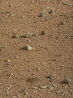
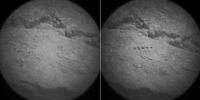
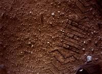
It seems that during Sol 19 a relatively loose rock or soil has (maybe the wheel tracks?) been shot 5 times with the laser leaving a little trail of holes:
|
Posted by: Astro0 Aug 26 2012, 09:04 AM
I hate to be first to say this but...
pew pew pew pew pew !!!!
Posted by: Gladstoner Aug 26 2012, 09:19 AM
.
Posted by: walfy Aug 26 2012, 09:21 AM
I borrowed Fred's excellent rendition to compare with HiRISE anaglyph of the prime science region around the inverted riverbed. It's a very narrow angle of view. If I marked some features wrong, please let me know.
|
The canyon between "A" and "D" will be epic, if they decide to rove up it. In Matthew Golombek's "Update on Landing Site Characterization" presentation, this canyon's traversability is marked in 4 places as "hasn't been investigated," and marked in 2 places as "small width path, less than 10 meters." Have they determined the traversibility since then, or will it be determined by the rover once it's in the vicinity? I would imagine the long lens in the Mast Cam could get some good shots from the base of the canyon and spot the rough patches. By the way, here's the page from the presentation with the possible routes:
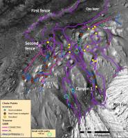
|
Posted by: paraisosdelsistemasolar Aug 26 2012, 09:31 AM
I love the outcrop near to point B in the walfy picture. It looks like a plane of ripples
Also, as Gladstoner says, it seems to be two different distributions of rocks over the soil, and the little ones seem to be more rounded (the bigger ones are now being actively being eroded by the wind as we can see in it shape).
Posted by: jmknapp Aug 26 2012, 11:41 AM
Just did it by eye in Photoshop--crop the ML, scale it up so that it matches the size of the similar area of the MR, apply level changes to RGB as appropriate, then fine tune the registration by eye using the Move tool and cursor keys until it looks about right. Lots of variables to mess up & it always seems like there are problem areas & as you say it gets a little brain-bending. But haven't tried correcting for distortions--maybe that's key. I suppose the pros use the full CAVHORE camera models to really do it right. Here's the best I can manage with one of the rover track pairs, without any geometric changes:
|
Looks like you might have stitched a couple of frames together? That's another complication to get right.
Posted by: malgar Aug 26 2012, 01:04 PM
I don't find the two debayered frames. I would like to try my anaglyph version. Could you post the two frames? thank you
Posted by: dvandorn Aug 26 2012, 04:23 PM
I believe the geologic term for this is sorting. The surficial material here at Bradbury Landing is well-sorted, meaning there is not a random distribution of particle sizes from fines to boulders. As John Grotzinger pointed out in an early press conference, this suggests the surface is a lag deposit, where a deflationary process has preferentially removed all of the particles of the sizes that are most easily transported by the given process, leaving a lag deposit of the particles that were harder to move and, literally, left behind. As an opposite example, the lunar regolith is considered to be poorly sorted, with impact processes being the only deflationary processes in place, and impacts tend to transport particles of all sizes non-preferentially.
One good reason why the surface is reminiscent of the blueberry paving in Meridiani is that, per the best theories I've heard, the Meridiani surficial material is also a lag deposit. The very soft, friable rock that once covered Meridiani has all been deflated by aeolian processes, leaving the much more massive blueberries (which aren't nearly as easily transported by wind) in place as a lag deposit.
The deflationary processes do tend to round the edges off the lag particles, resulting in the more rounded appearance.
On Earth, a similar process would be the one that paves a creek bed with well-sorted, rounded pebbles. The transport mechanism (water) may be different from the primarily aeolian processes that have held sway on Mars for giga-years, but the principle is basically the same.
-the other Doug
Posted by: jmknapp Aug 26 2012, 04:46 PM
I think we're on our own for debayering (demosaicing) the frames. This page has what I got anyway:
http://curiositymsl.com/mcana/
The hills have those weird green patches that people are getting. It'd be interesting to see how JPL does it (http://mars.jpl.nasa.gov/msl/images/pia16068_Grotzinger-5promisedland-br2.jpg)
Posted by: Airbag Aug 26 2012, 06:15 PM
Presumably they work with the original images, not the jpeg (re-)compressed versions we see, and hence they do not have to deal with jpeg compression artifacts interfering with the de-Bayer process.
Airbag
Posted by: Gladstoner Aug 26 2012, 08:48 PM
.
Posted by: Phil Stooke Aug 26 2012, 08:49 PM
A whole pile of new images just appeared:
http://mars.jpl.nasa.gov/msl/multimedia/raw/?s=19
But not the hazcams or navcams I was hoping for to confirm a drive (we haven't got images from that sol yet, still on sol 19). Mastcam thumbnails point to some great scenes when the full images come down.
Phil
Posted by: ngunn Aug 26 2012, 09:39 PM
ChemCam is already working. A nice article from Science Daily - basalt apparently: http://www.sciencedaily.com/releases/2012/08/120824093521.htm
Posted by: Stu Aug 26 2012, 09:41 PM
Looking forward to those. Got my special glasses ready...

|
Posted by: Phil Stooke Aug 26 2012, 10:01 PM
De-bayer that!
Phil
Posted by: ngunn Aug 26 2012, 10:41 PM
Go with ugordan.
(or Airbag).
Posted by: Mars3D Aug 27 2012, 12:21 AM
It's been a while since I did any of these but here's a flyover animation showing the area around the base of mount Sharp and the destination for the MSL. http://www.youtube.com/watch?v=bMdE9t5aSaM&feature=vmdshb
To give an idea of scale the rock in front of you at 15 seconds is about 140m high.
I used the DTM and image data from http://hirise.lpl.arizona.edu/dtm/dtm.php?ID=PSP_009149_1750
Posted by: Brian Lynch Aug 27 2012, 12:45 AM
That is a great video Mars3D, I tried finding Mars Explorer but only found a multiplayer driving game, where can I find the one that you used?
Posted by: jmknapp Aug 27 2012, 01:37 PM
If that's what's causing the yellow/green artifacts, then providing bayer->jpg files instead of bayer->demosaiced->jpg files is no favor.
This page describes an "advanced" algorithm:
http://www.ipol.im/pub/algo/bcms_self_similarity_driven_demosaicking/
Applying that to one of the mastcam bayered images (http://mars.jpl.nasa.gov/msl-raw-images/msss/00017/mcam/0017ML0050033000C0_DXXX.jpg) on the public website gives this:
|
Zooming in on a small area on the nameplate to show individual pixels:
|
So we're screwed?
Posted by: mcaplinger Aug 27 2012, 02:11 PM
I've lost track of what's concerning you guys.
Straight bayer images were sent down as part of a calibration activity. We demosaic them and look at them, they're fine. Then JPL JPEG-compresses the original raw files for public release and and introduces these artifacts, which is clearly the wrong thing to do. Fortunately I think the use of raw files will be rare, so this should be an isolated incident.
Posted by: fredk Aug 27 2012, 02:22 PM
Edit: thanks for that, mcaplinger. I was surprized that we were seeing these bayer images considering the bandwidth required.
Posted by: fredk Aug 27 2012, 02:36 PM
Posted by: jmknapp Aug 27 2012, 03:02 PM
Ah, didn't know that the raw "bayer" images sent so far are for calibration & that the norm will be demosaiced. Sorry if I missed that explanation somewhere.
Posted by: mcaplinger Aug 27 2012, 03:23 PM
Yes, but I'm not sure they're distinguishable in any meaningful way from high-quality JPEGs; the old raw versus compressed debate familiar to all digital photographers. I'd rather have five JPEGs than one raw myself.
Based on looking at the public website thumbnails, the next batch of images will have been compressed with varying JPEG quality. Then I think they'll be decompressed and recompressed at a constant quality for public release, so I'm not sure what they'll look like. Be warned.
Posted by: fredk Aug 27 2012, 04:08 PM

Seriously, mcaplinger, endless thanks for all the input you provide here!
Posted by: Stu Aug 27 2012, 04:54 PM
You were lucky...

Posted by: Phil Stooke Aug 27 2012, 05:48 PM
Luxury!
Phil
Posted by: Eutectic Aug 27 2012, 06:25 PM
Good thing we don't have to hand-color the pixels as was done with Mariner 4.
http://solarsystem.nasa.gov/multimedia/display.cfm?Category=GreatShots&IM_ID=13006
|
Regarding the rounded granules at Bradbury Landing, they look tumbled. The larger cobbles have the usual ventifact facets from long exposure; they're too big to turn over. But the smaller stuff looks really rounded. The Meridiani blueberries started out spherical and harder than the sulfates and hydrated silicates that entombed them; it will be interesting to learn if the round granules and pebbles here have a favored composition. Presumably Earth's favorite weathering-resistant mineral, quartz, is not available here, but kilometers of sediment have been removed from this location -- a very thick column to select lag materials from. Rounding and sorting might have accompanied their original deposition more than the current environment.
Posted by: fredk Aug 27 2012, 06:43 PM
http://www.nasa.gov/multimedia/nasatv/MM_NTV_Breaking.html
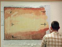
Posted by: climber Aug 27 2012, 07:03 PM
|
|
This guy got THE very appropriate shirt to do the job.
Posted by: ElkGroveDan Aug 27 2012, 07:20 PM
I think this is the one that's hanging in the JPL media office. If I recall correctly Doug took a gigapan of the finished product which I am sure is accessible somewhere.
Posted by: Stu Aug 27 2012, 07:22 PM
Actually, if you run that shirt through a deBayer filter it looks quite nice...
Posted by: ElkGroveDan Aug 27 2012, 07:44 PM
UMSF: Providing headache relief for space image fans everywhere.

|
Posted by: john_s Aug 27 2012, 09:06 PM
Of course- it's actually a tie-dye!
Posted by: Josh Cryer Aug 27 2012, 09:13 PM
Pic from todays briefing: http://i.imgur.com/76icp.jpg
Just wow.
edit: on the site now: http://mars.jpl.nasa.gov/msl/multimedia/images/?ImageID=4569
Posted by: charleski Aug 27 2012, 09:34 PM
From the Press conference - the animation they showed implied that MRO and Ody have quite a lot of overlap in their overpasses (i.e. there are times when they're both over the horizon at the same time). Can Curiosity relay different streams to each of them to maximise bandwidth?
Posted by: Phil Stooke Aug 27 2012, 09:40 PM
... and they have now driven to a point where DAN can get data from one of the scours. There for a few sols, then head for Glenelg.
Phil
Posted by: Tesheiner Aug 27 2012, 10:00 PM
Just wow.
edit: on the site now: http://mars.jpl.nasa.gov/msl/multimedia/images/?ImageID=4569
And to have a sense of scale, just look to the "tiny" rock almost dead centered on the picture at x, y coordinates 534,328. That's the rover-sized rock Mike Malin talked about.
Incredible!
Posted by: nprev Aug 27 2012, 10:05 PM
Phenomenal.
We're in the right place with the right rover.
Posted by: Ant103 Aug 27 2012, 11:22 PM
Sol 21 Navcam pan, in anaglyph. Classic version available on the link :
http://www.db-prods.net/marsroversimages/curiosity.html#sol21
Also, that was a great press briefing, especially the part with the "badlands" and the rover-scalled-rock.
Posted by: scalbers Aug 27 2012, 11:26 PM
And nice at the briefing to see John Grotzinger talk about the large unconformity on Mt. Sharp (earlier mentioned in UMSF by Emily, and asked about by her at the press conference) and to compare it with the Grand Canyon.
Posted by: Brian Lynch Aug 28 2012, 12:02 AM
Thanks, Ant, that stereo panorama looks great through shutter glasses, here is the .jps file if anyone else has a 3D display (assuming I have Ant's permission!).
https://dl.dropbox.com/u/97443049/Sol21_pano_ana.JPS
Posted by: jmknapp Aug 28 2012, 01:20 AM
It's pretty rare that they're both up at the same time, based on the NAIF data published. It's probably more important that they fill each other's gaps. MRO has an interesting pattern:
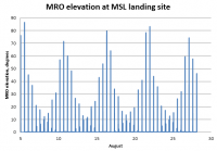
|
So there's about a 6-day periodicity. ODY passes are a little less regular, but put them together & you get this for August to date:

|
The graphs show the passes at night too. I think they've used some of those.
Posted by: atomoid Aug 28 2012, 02:00 AM
edit: on the site now: http://mars.jpl.nasa.gov/msl/multimedia/images/?ImageID=4569
beautiful!
it would seem http://rd.springer.com/article/10.1007/s11214-012-9910-4/fulltext.html at section 6.1 http://rd.springer.com/static-content/0.5088/images/929/art%253A10.1007%252Fs11214-012-9910-4/MediaObjects/11214_2012_9910_Fig18_HTML.jpg is now seeming quite prescient indeed given the scenery were already seeing!
Posted by: CosmicRocker Aug 28 2012, 02:51 AM

Posted by: Ondaweb Aug 28 2012, 12:46 PM
In response to the last question about sunrise at Gale, I later thought a sunset picture with the silhouette of the rim against Sharp while the basin was dark might look cool. Given the low atmospheric pressure and subsequent low scattering, it might be pretty dramatic. And Curiosity should be able to take such a picture given where it's located.
Posted by: fredk Aug 28 2012, 02:59 PM
Pressure is low but dust is high, so scattering tends to be high. Not to say that low-sun shots aren't dramatic, of course...
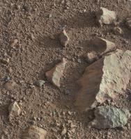
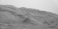
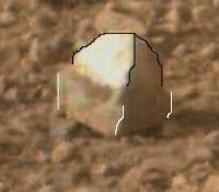
A couple of new de-Bayered mastcam 100 views from sol 17, both Fourier filtered to reduce jpeg artifacts:
|
|
Near centre in that last frame: how about "whitecap" for a nickname?
Posted by: dvandorn Aug 28 2012, 03:57 PM
"Whitecap" definitely shows a contact in the rock. I think this makes it very clear that the light-toned chips we've been seeing in the pavement aren't just reflected light off of shiny surfaces. There is a very nearly white rock mixed into this pavement, and whitecap shows that the light-toned rock is nearly as hard as the gray, apparently basaltic rocks. Note that it has been wind-eroded to the same degree as the very dark band across the contact and the lighter gray unit that forms the base of the rock. No little shelves that would indicate different degrees of erosion, and therefore hardness, for each rock type.
-the other Doug
Posted by: Phil Stooke Aug 28 2012, 04:59 PM
Ant's nice panorama in circular format. The tracks help clarify the pattern of movement.
Phil
|
PS if I read Twitter correctly, another drive today?
Posted by: tdemko Aug 28 2012, 06:16 PM
Doh! That is a shot from my dissertation area, a place called The Tepees, in Petrified Forest National Park. I could go on for pages, of course, but the colorful striped strata there record the incision of a fluvial system and subsequent backfill by high sinuosity point bar and overbank deposits. The red horizon is a relatively mature paleosol that marks the final fill and overtopping of the incisional topography.
If Curiosity finds these types of deposits, I'm quitting my job and going on Mars time!
Posted by: Phil Stooke Aug 28 2012, 08:15 PM
Current map - the most recent drive shape is not well defined yet.
Phil
|
Posted by: Mars3D Aug 28 2012, 09:01 PM
Thanks Brian, I'm afraid Mars Explorer isn't downloadable, I haven't released it.
Posted by: fredk Aug 28 2012, 09:04 PM
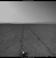
Looks like a short drive on sol 22 - off to Glenelg we go!
|
Posted by: akuo Aug 28 2012, 09:32 PM
Excellent! We know we love drives On with the exploration!
I like how the mast in the corner of the rover brings new views, like the two wheels in the same navcam view here:
http://mars.jpl.nasa.gov/msl-raw-images/proj/msl/redops/ods/surface/sol/00022/opgs/edr/ncam/NRA_399455767EDR_F0030260NCAM00413M_.JPG
I guess the corner mounted mast also makes it easier to image almost straight down to the ground, unlike with MERs.
Posted by: fredk Aug 28 2012, 09:44 PM
|
Unfortunately that was mastcam 100, so probably the best look we'll get of ol' whitecap.
Posted by: RoverDriver Aug 28 2012, 11:30 PM
...
Hey, give me a break, it was my first one
It was about 15 meters total.Paolo
Posted by: Floyd Aug 29 2012, 12:25 AM
Go Paolo! Congratulation on your first Curiosity drive. Keep up the great work--we will follow--looking over your shoulder.
Posted by: Oersted Aug 29 2012, 12:36 AM
Great to see this web site becoming evermore important... Not only are members stitching together panoramas... Now they're also driving the vehicle! ;-)
Joking aside, "auguri Paolo!" on your 1st of hopefully many drives! Remember now to always pull the hand brake and put her in first gear when you park on a slope... :-)
Btw, from living for four years in Italy I can attest to Italian drivers being supremely attentive and having lightning reactions, great skill and precision. They need to,driving in Italy! So our rover is definitely in good hands...
Posted by: NickF Aug 29 2012, 12:58 AM
A debayerised stitch of 'whitecap' and friends.

|
Posted by: Ant103 Aug 29 2012, 01:29 AM
Sol 22 Navcam pan :
http://www.db-prods.net/marsroversimages/Curiosity/2012/Sol22_pano.jpg
And here go some imagery routine
Posted by: dvandorn Aug 29 2012, 02:04 AM
Nice catch on whitecap, fredk. Though I'm only prepared to fully agree with the left side, the front and right may not be as differentially eroded. But, yeah -- the white rock looks to be a little on the softer side of the Mohs scale.
I'm really impressed with that contact, though. It really appears that there is a very dark band of rock sandwiched between the very white rock and the gray, apparently basaltic rock that forms the base of this particular ventifact.
Now, this would seem to me to be a really excellent target for ChemCam -- the ability to analyze each of the three strata in a rock like this seems like exactly the kind of thing ChemCam was designed for.
-the other Doug
Posted by: RoverDriver Aug 29 2012, 04:10 AM
No driving today (Sol 23), but hopefully tomorrow (Sol 24) and on Sol 25 as well.
Paolo
Posted by: JohnVV Aug 29 2012, 05:23 AM
for now Sol 17 Mosaics from the Mast Camera
http://imgbox.com/adqP5gys http://imgbox.com/acdEdDOK
Posted by: Phil Stooke Aug 29 2012, 07:14 AM
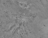
Ant's new pan in circular form. Two little craters and a rocky hill in front are visible in HiRISE to locate the site, but I don't have time right now to plot that.
Phil

|
Posted by: Tesheiner Aug 29 2012, 07:16 AM
And here go some imagery routine
Here is your sol 21 mosaic with an estimation of sol 22 position.

|
Posted by: akuo Aug 29 2012, 08:45 AM
New MARDI images on sol 21! I wondered for a minute about the rectangular features visible in the thumbnail images, until I realised that it must be the sunlight shining from above the rover, and the rest of the images are in shadow.
http://mars.jpl.nasa.gov/msl/multimedia/raw/?s=21&camera=MARDI
Posted by: climber Aug 29 2012, 08:45 AM
Did we start using the old (what was the name, drunk driver?) drive? Or does Paolo heating the tires?
Posted by: charleski Aug 29 2012, 08:46 AM
Apparently MRO's flypass is about an hour later than Ody's, with both appearing at 12-hour intervals.
Posted by: RoverDriver Aug 29 2012, 09:51 AM
We were calling it drunken sailor. We drove backwards for 3.3 meters, turned around at a heading of 112 deg and drove for about 10.8 meters. The weird path was due to several constraints for final position and desired heading. Tequila was not involved.
Paolo
Posted by: paraisosdelsistemasolar Aug 29 2012, 09:56 AM
The new MastCam 100 raw frames from Sol 19 just arrived. I made a quick panorama showing the level of detail. Click on the image for a bigger version.
http://www.ungeologoenapuros.es/0019MR0054000000C0_DXXX-Panorama.html
Greetings!
NOTE: This post is edited, now you can see the panorama in zoomify viewer.
Posted by: jmknapp Aug 29 2012, 10:26 AM
Nice! To practice geology without a license:

|
Landslides?
EDIT: Here's a HiRISE crop at 27cm/pixel:

|
Posted by: climber Aug 29 2012, 11:01 AM
I don't think that James' computer will survive this time. So rich and so many things to look at.
On the third strip from the left and on its lower right side, there is a "home plate" like mesa (wayyy much bigger for sure).
Posted by: Tesheiner Aug 29 2012, 12:49 PM
This one?

|
Posted by: climber Aug 29 2012, 01:03 PM
This very one, yes.
Posted by: dilo Aug 29 2012, 03:42 PM
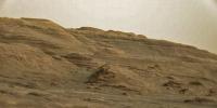
Some days ago I was watching the chinese movie "Hero" and I was strongly impressed by the similitude of a particular location and the hills at the base of Mt Sharp:

|

|

|
(sorry for the bad quality, I used trailer screenshots because I am not able to take images from my BD).
Do someone knows exactly where this place is and which is his geology?
Posted by: fredk Aug 29 2012, 03:51 PM
A few of my favourites from the sol19 mastcam100 batch, Fourier filtered but unstretched:

|

|

|
And a crop showing the prominent crater at the base of the mound:

|
Posted by: Antonb Aug 29 2012, 04:17 PM
I believe this was shot in the Yardang National Geological Park, Dunhuang, in China's Gobi Desert. Google it to see lots of wind-eroded rock forms that do look like some things we're seeing on Mt Sharp. I was struck in particular by this pic:

|
Posted by: Paolo Aug 29 2012, 05:13 PM
cool! I've been twice to the Mongolian side of the Gobi, I need to see the Chinese side sometime...
Posted by: Phil Stooke Aug 29 2012, 05:46 PM
"NOTE: This post is edited, now you can see the panorama in zoomify viewer."
Very nice mosaic! But is there a way to download the mosaic?
Phil
Posted by: paraisosdelsistemasolar Aug 29 2012, 05:55 PM
Of Course Phil, you can download it from here http://www.ungeologoenapuros.es/wp-content/uploads/2012/08/0019MR0054000000C0_DXXX-Panorama.jpg. I hope in the next MRO and Odyssey they upload new frames to complete it
Posted by: Ant103 Aug 29 2012, 06:24 PM
An other loooooong processing (some error in control points finding, optimisation, etc.). The debayerisation process is not as good as I want, I will try some other way to do that.
http://www.db-prods.net/marsroversimages/curiosity.html#sol19
Posted by: Phil Stooke Aug 29 2012, 06:25 PM
Beautiful - thanks for that.
Paolo - an experimental reprojection of the sol 22 rear hazcam (so bad that I'm not going to post it) suggests that you drove right over the scour to its northern side before turning east. Can you confirm that?
Phil
Posted by: RoverDriver Aug 29 2012, 06:42 PM
Yes. We had driven over the Goulburn scour on Sol 21 to place DAN over it. On Sol 22 we drove backwards for 3.3 meters, did a mid-drive NAVCAM and turned to about 112 and drove 11 meters or so.
Paolo
Posted by: Pando Aug 29 2012, 08:57 PM
Awesome work Phil! I think you (or Mods) should start a "Curiosity Route Map" thread and make it a sticky like we did with MER
^ This would be a great first post there...---
Mod: Done.
Posted by: RoverDriver Aug 29 2012, 09:10 PM
Very sticky, I hope. Phil, your map is consistent with what I have.
Paolo
Posted by: paraisosdelsistemasolar Aug 29 2012, 10:02 PM
Phil, thanks for the situation map.
I also have updated the panorama from MastCam 100 with the new frames and you can see it here: http://www.ungeologoenapuros.es/0019MR0054000000C0_DXXX-Panorama.html
Posted by: fredk Aug 29 2012, 10:12 PM
Drool, droool...

|
Posted by: Phil Stooke Aug 29 2012, 10:19 PM
With pictures this good we don't really need to go there.
Phil
PS if the mods want to set up a map thread that's good with me. I will contribute to it and I hope others will give their own versions as well. My maps are preliminary versions of something I will eventually publish, so they are being made consistent with what I am doing for Spirit and Opportunity (and did for Sojourner in my Mars first volume due out soon)
Posted by: Oersted Aug 30 2012, 12:26 AM
I have a deeply felt request if we're now embarking on route maps. I really really think we should try to get all the little squiggles and wiggles showing in the route line. The straight lines between sols don't really tell a true story of how the drives actually looked. I feel they make the drives look too "cleansed". And we do have the information! The hazcam shots show exactly how each drive has progressed. If the information is there it should be presented ss comprenhensively as possible, especially since it tells a truer story of how driving on Mars really looks.
This goes for the detailed route maps and of course not for overview maps in low-res where a simplification of the actual route is in order.
I know it is a good deal more complicated to make such maps when compared to the MER route maps, but I think it would be well within the capabilities of the excellent map makers here at UMSF.
Posted by: RoverDriver Aug 30 2012, 12:37 AM
How accurate would you like the maps to be? The current map is correct since we drove in straight line segments. The Sol 22 drive used a GTW for the first time but the path was almost perfectly straight. Unless we drive with VO all the time there will be errors in the reported telemetry so you will never know exactly where the rover has been unless we take HiRISE every so often. The end of drive locations will be co-registered with HiRISE but not the tracks.
Paolo
Posted by: nprev Aug 30 2012, 01:09 AM
Thank you, Paolo.
In my opinion, point A to point B mapping is more than good enough...and one hell of a lot more than anyone should even ask for who ain't payin' for it.
Just be happy and extremely grateful if we ever get it.
Posted by: fredk Aug 30 2012, 01:30 AM
It may be harder to do that with MSL, since we don't (yet) have an equivalent to the MER pancam database.
Posted by: dilo Aug 30 2012, 07:08 AM
Thanks Antonb!
Posted by: Phil Stooke Aug 30 2012, 07:34 AM
Regarding the route maps - they will be as accurate as they can be with the information available to me. Hazcams will help if they face the right way and the drive is short - they are never going to see back very far for long drives. Ideally we would have rear-facing navcams at least. For most MER drives there were full 360 navcam panoramas which is ideal, so we will just have to see what shows up. These maps will also be corrected where necessary from HiRISE images, maps released by the mission team and so on. On the other hand, MER experience shows that most drives tend to be fairly straight lines most of the time.
Phil
Posted by: ollopa Aug 30 2012, 08:30 AM
GTW?
Posted by: Antonb Aug 30 2012, 09:03 AM
Following yesterday's post about yardang rock formations in China, I've been looking for pairs of pics that underline the similarities between certain Mars and Earth geological features. Compare these two pics for example:
1. Yardangs on Mt. Sharp, Gale Crater, Mars.

|
2. Yardangs in the Tsaidam Desert, Qinghai Province, China.

|
Posted by: Antonb Aug 30 2012, 10:00 AM
PS: If you flip the China pic L?R like this, the resemblance to the Mars pic is so uncanny it looks like I've faked it. Here's the source: http://www.pbase.com/phiw/yardang

|
Posted by: RoverDriver Aug 30 2012, 11:08 AM
I apologize, I was in a hurry. GTW stands for GO_TO_WAYPOINT a command sent to the rover where you specify only the location you want to drive to and the FSW (Flight SoftWare) decides how to get there.
Paolo
Posted by: jmknapp Aug 30 2012, 11:27 AM
It is rather uncanny. Nice how your photo has a "rover" with a camera too!
Posted by: Antonb Aug 30 2012, 12:29 PM
For a good expnation of the processes involved in the China yardang formations, see http://www.geosociety.org/gsatoday/archive/21/4/pdf/i1052-5173-21-4-4.pdf. To create such similar landforms, the sequence of uplift (in China, tectonic; in Gale Crater, metoric) followed by long-term, massive, dry erosion by uni-directional wind (which creates the teardrop yardang shape) is likely to be the same, if over a longer timescale on Mars because of its very low atmospheric pressure.
PS: apologies if I'm going off topic on this thread, still a newbie here. Let me know if there's a more appropriate thread for rockhounding. Thanks.
Posted by: centsworth_II Aug 30 2012, 01:54 PM
That's fredk's Mystery Man!

|
Posted by: tolis Aug 30 2012, 05:33 PM
Curiosity's drivers should look out for Sand People. They are known to snare careless little droids
and sell them to the Jawas.
Tolis.
Posted by: Greenish Aug 30 2012, 05:49 PM
Paolo
Thanks. I was close; I guessed GO_THAT_WAY.
Posted by: djellison Aug 30 2012, 08:56 PM
What's stopping you? There's a thread explicitly for it. Get going!
http://www.unmannedspaceflight.com/index.php?showtopic=7442
Posted by: Oersted Aug 30 2012, 09:24 PM
Got it! Replied in that thread.
Posted by: jmknapp Aug 30 2012, 10:16 PM
Smallest NAVCAM image returned yet, just an hour or so ago:
http://mars.jpl.nasa.gov/msl/multimedia/raw/?s=24&camera=NAV_LEFT_A
1x1 pixel
On the other hand there was only about an hour delay between when it was taken and when it showed up on the raw site.
Posted by: Pando Aug 30 2012, 10:48 PM
Cool! We're all eager to get more of them to stitch a panorama.
Posted by: fredk Aug 30 2012, 11:32 PM
Posted by: jmknapp Aug 30 2012, 11:36 PM
Oh my Godit's full of stars!
Posted by: jamescanvin Aug 31 2012, 12:08 AM
OK so I wrote my own demosiaicing algorithm, included a Fourier filter and a 'detect suspiciously green pixels and look for something more Mars-like nearby' procedure. Still have a greenish cast in many areas but I'm making progress.
http://www.nivnac.co.uk/mer/index.php/msl19
Click for image download options, including full 80 Megapixel 17MB version and Zoomify if you don't want to tackle that!
James
Posted by: jmknapp Aug 31 2012, 12:45 AM
The timestamps on the raw image files--the time the image was taken--have been coming in the early afternoon, local solar time. To get an idea of the typical MSL workday, at least as far as picture-taking is concerned, here are the statistics for the first 5000 or so images:
11am-12pm 1
12pm-1pm 602
1pm-2pm 516
2pm-3pm 640
3pm-4pm 3426
4pm-5pm 150
The 3pm-4pm bin is heavily skewed by the MARDI images.
So no morning or sunset shots yet (sunset is currently 5:21pm and sunrise 5:26am). Is it necessary, at least at this point in the checkout, to operate the cameras only in the heat of the afternoon?
Posted by: elakdawalla Aug 31 2012, 02:41 AM
Remember that engineering camera images -- Navcams and Hazcams -- tend to be taken toward the end of the day, to document the final position of the rover after any movement, right before the afternoon downlink. They're taken during the day too, obviously, to document whatever's happening as it happens, but full navcam pans will tend to be taken in the afternoon.
Posted by: RoverDriver Aug 31 2012, 08:47 AM
So no morning or sunset shots yet (sunset is currently 5:21pm and sunrise 5:26am). Is it necessary, at least at this point in the checkout, to operate the cameras only in the heat of the afternoon?
Although I'm not an ECAM or MASTCAM PUL, I would venture to say they want to avoid heating either the mechanisms and/or the electronics to capture images early in the morning and late in the evening.
Paolo
Posted by: jmknapp Aug 31 2012, 09:22 AM
OK, had to look up http://msl-scicorner.jpl.nasa.gov/scienceoperations/.
Granted you're not necessarily going for artsy or pretty but it's axiomatic in nature photography that morning and evening light is the best. It'd be interesting to see how that mileage might vary with Mars atmospherics. Maybe sometime down the road.
Just a thought, "HDR" has been kind of a fad in recent years, where dynamic range is extended by combining multiple shots taken at different exposure levels--particularly where there are areas of bright sunlight and dark shadow in the frame, say, in the foothills and canyons of Mt. Sharp. Maybe that would require even more than an "intermission"--a vacation for MSL?
Posted by: RoverDriver Aug 31 2012, 10:02 AM
Granted you're not necessarily going for artsy or pretty but it's axiomatic in nature photography that morning and evening light is the best. It'd be interesting to see how that mileage might vary with Mars atmospherics. Maybe sometime down the road.
Just a thought, "HDR" has been kind of a fad in recent years, where dynamic range is extended by combining multiple shots taken at different exposure levels--particularly where there are areas of bright sunlight and dark shadow in the frame, say, in the foothills and canyons of Mt. Sharp. Maybe that would require even more than an "intermission"--a vacation for MSL?
We had done some early morning and late afternoon photography on Mars with MER and I love those shots. Not only because they look good but also you can see the terrain better. MSL has done her part with her first FHAZ with long shadows. I'm sure they will do that some time. About the HDR thing, as the cameras already have 12 bit depth I'm not sure we would need many frames to expand the dynamic range. These are the typical things that can be done during conjunction for example. I will keep that in mind.
Paolo
Posted by: jmknapp Aug 31 2012, 11:05 AM
They have 12-bit ADCs but considering the SNR, effectively somewhat less? If so, the nearly dark areas would be noisy. But overexpose to get more electrons in the wells for the dark areas & more real detail could be brought out.
On another topic, here's a shot taken yestersol by NAVCAM:
http://mars.jpl.nasa.gov/msl-raw-images/proj/msl/redops/ods/surface/sol/00024/opgs/edr/ncam/NRA_399627511EDR_F0030372NCAM00407M_.JPG
Is that a scientifically interesting outcrop in the near left? Here's an anaglyph:
|
The terrain around your rover always looks a lot more uneven with 3D than I expect.
Posted by: tfisher Aug 31 2012, 11:28 AM
Its looking good! If you're still interested in off-the-shelf solutions, I see very nice results with the http://gmic.sourceforge.net/gimp.shtml. It has a Bayer reconstruct filter which with the default settings avoids the green patches other de-Bayer methods are giving.
I've also been working on some custom code for the problem, that works at the level of the raw jpeg data to try to correct the decimated dct coefficients for bayer bias. Maybe I'll have something to share on that soon. I was originally pretty motivated by the nasty green patches, but then I discovered that G'MIC mostly solves that issue without such fancy custom techniques.
Posted by: Nix Aug 31 2012, 12:58 PM
IMG
Click for image download options, including full 80 Megapixel 17MB version and Zoomify if you don't want to tackle that!
James
That looks awesome James, whatever progress you make over this, I'm very pleased to appreciate all the detail in the mountain in full color
Posted by: fredk Aug 31 2012, 02:51 PM
http://mars.jpl.nasa.gov/msl-raw-images/msss/00017/mcam/0017MR0050002000C0_DXXX.jpg
http://mars.jpl.nasa.gov/msl-raw-images/msss/00017/mcam/0017ML0050032000C0_DXXX.jpg
It'd be great if we could see what it can do before thinking about installing gimp...
Posted by: Marvin Aug 31 2012, 04:54 PM
A large bunch of raw images are available for Sol 24, many full data:
http://mars.jpl.nasa.gov/msl/multimedia/raw/?s=
I believe you can see Bradbury Landing and the visit to the Goulburn Scour in this image, then the tracks lead further on:
http://mars.jpl.nasa.gov/msl-raw-images/proj/msl/redops/ods/surface/sol/00024/opgs/edr/ncam/NRA_399627727EDR_F0030372NCAM00406M_.JPG
Rear Hazcam:
http://mars.jpl.nasa.gov/msl-raw-images/proj/msl/redops/ods/surface/sol/00024/opgs/edr/rcam/RRA_399627458EDR_F0030372RHAZ00303M_.JPG
Posted by: Deimos Aug 31 2012, 05:03 PM
I am one ...
... and I agree. And, for many things, time of day is a significant aspect of planning. Speaking for myself, I don't mind heating the things when needed. But working outside of the warmest part of the day could mean heating cameras, electronics, and especially actuators for pointing, focusing, etc. Hazcam doesn't have those issues. This part of the mission is not the time to stress either the thermal or the power systems (soon, I hope!). And while I don't mind heating, the power gurus (or other camera types) might... . Of course, for some things, morning/evening light isn't so good. Shadows are dramatic, but they may not convey the kind of information you want. Nonetheless, I'd like to see such images be part of the repertoire.
I'm not sure about this. Not all cameras handle saturation gracefully. I've done multiple-exposure levels on MER, with cameras that don't do saturation well, meeting with partial success. We need experience to figure how valuable HDR can be (versus, for instance, individual, well-exposed, lossless images).
Posted by: Ant103 Aug 31 2012, 06:03 PM
Sol 24 Navcam pan It's good to see some tracks behind the rover. The sign we are on the road.
http://www.db-prods.net/marsroversimages/Curiosity/2012/Sol24_pano.jpg
Posted by: Tesheiner Aug 31 2012, 06:22 PM
Very nice. I'm using autostitch, which for MER was just fine, but it is having trouble assembling the images around the MMRTG.
Edit: And my attempt locating the current site. It's not easy 'cause the terrain is almost featureless.

|
Posted by: RoverDriver Aug 31 2012, 06:26 PM
We could take multiple images at the same exposure time to reduce the noise. This was done on MER MIs but I'm not sure how useful it was. I will ask.
http://mars.jpl.nasa.gov/msl-raw-images/proj/msl/redops/ods/surface/sol/00024/opgs/edr/ncam/NRA_399627511EDR_F0030372NCAM00407M_.JPG
Is that a scientifically interesting outcrop in the near left?
I think it is on our way to Glenelg so I think we will have a chance to see it from a closer distance.
That is true, but remember we have a big truck on Mars
Paolo
Posted by: Phil Stooke Aug 31 2012, 07:06 PM
Drive looking good!
Yes- I said no map posting. I can read and post text but can't do graphics for2 weeks (The humanity!) So I will be watching every day. Keep it up Paolo...
Phil
Posted by: Mick Hyde Aug 31 2012, 07:21 PM
Sorry to jump in on this post but I ran some tests myself using GIMP and G'MIC plugin:-

|

|
Cheers
Mick Hyde
Posted by: Doc Aug 31 2012, 08:58 PM
It's good to see some tracks behind the rover. The sign we are on the road.We certainly are Ant. Great pan.
Posted by: jmknapp Sep 1 2012, 12:49 AM
Fair enough--little steps seem the way to go at first with a two-year mission ahead. With each report I'm in awe that everything works so well. At lunch today I brought up a recent raw NAVCAM photo on my Kindle Fire & showed it to some people who aren't necessarily following the mission super closely. It was the picture of the rover http://mars.jpl.nasa.gov/msl-raw-images/proj/msl/redops/ods/surface/sol/00024/opgs/edr/ncam/NRA_399627727EDR_F0030372NCAM00406M_.JPG. You should have seen the smiles & it prompted a lot of talk about the possibility of life on Mars, future manned missions, incredible engineering achievement, etc.
Posted by: RoverDriver Sep 1 2012, 01:12 AM
That image was sequenced to assess where the vehicle actually drove during the autonav checkout (sol 24). The fact it is an awesome picture is just a coincidence. We intentionally drove straddling a 17-19 cm tall rock to see if autonav would see the rock. Autonav was used only to evaluate the terrain but not to actually pick a route or stop the vehicle. We analyzed cm by cm the route before letting our baby go of course. It was my second drive on MSL, an all nighter shift.
Paolo
Posted by: pmetschan Sep 1 2012, 02:56 AM
So how did the vehicle respond to the ~17cm rock? From your post above it seemed a bit like you were intentionally testing her?
Posted by: tfisher Sep 1 2012, 04:53 AM
Thanks. Yes, that agrees with what I see. There are some clear repetitive artifacts from the interference between the Bayer pattern and the jpeg compression, but at least with this Bayer reconstruction filter it shows up more in the luma rather than chroma.
Posted by: RoverDriver Sep 1 2012, 05:18 AM
We are still reviewing the results, but it appears she responded exactly as we expected it to, in fact slightly better (faster) than expected. We were indeed testing her. Although we had already tested her twin here on Earth plenty of times, we wanted to test her FSW (Flight Software) in real conditions on Mars. Today we will be testing her VO (Visual Odometry) module. Again, even after exhaustive testing here on Earth we want to make sure all is well before making use of both VO and guarded motion.
Paolo
Posted by: Mick Hyde Sep 1 2012, 10:51 AM
Apologies for putting this here, I tried to send this info to a user via a message, but got a 'recipients inbox was full' error message.
ADMIN NOTE: If the recipient knows who they are, can they clear their mailbox.
I'm a bit of a novice when it comes to GIMP, I tend to use CS5 and Lightroom myself, but I'll tell you what I know.
Gimp itself is very easy to install, I have a Windows 7 64bit machine and it installed in C:\Program files\GIMP 2.
The G'MIC plugin is also easy to install, just unwind the zip file and put all the files into the C:\Program files\GIMP 2\lib\gimp\2.0\plugins directory.
Don't follow the readme instructions because they seem wrong.
When you fire up GIMP go to File - Open and grab an MSL file.
Then Image - Mode and select RGB
Then Filters - G'MIC... (at the bottom) expand Degradations filter and click on Bayer Reconstruction.
Accept the defaults and click on OK
You can then use Crop tool to crop and I save using Export in the File menu.
Posted by: Tesheiner Sep 1 2012, 11:53 AM
Here's Ant's beautiful http://www.unmannedspaceflight.com/index.php?s=&showtopic=7426&view=findpost&p=190354 in polar form. North is up.

|
Posted by: jmknapp Sep 1 2012, 02:23 PM
The mastcam bayer images have a "C" in the file name, e.g.,
0017MR0055007000C0_DXXX.jpg
Otherwise it's "E" for full-frame color or "I" for a thumbnail. Does "C" refer to calibration image?
Hopefully if this is just a calibration phase, de-bayering will only be a passing need.
Posted by: fredk Sep 1 2012, 02:36 PM
That's what it sounded like from mcaplinger's comments - calibration.
Remember that the C images are lossless - that means very pretty images when we get access to the original data. So green splotches now, but very clean images later. Of course as people have said, that requires lots of bandwidth, so we could get more images back if they're jpegged on Mars. But I think it's fantastic that we'll have this lossless sequence covering the lower mound.
Posted by: Juramike Sep 1 2012, 09:57 PM
Comments and advice are welcome!
Greetings!
That's really nice! It reallys bring it home. I can almost imagine the sound and feel it would make as it crunches under one's foot.
Posted by: charleski Sep 1 2012, 10:45 PM
Paolo
The KAI-2020 sensor only has 60dB of dynamic range at full resolution, so I suspect that it produces no more than 10bits under optimal exposure at base ISO. The images so far have all been pretty flat, though, with only about 7 bits of contrast. But it might be worthwhile to try a couple of bracketing shots if you get up above the haze (in a year or two
).
Posted by: mcaplinger Sep 1 2012, 11:35 PM
That's at 40 MHz, though, and we aren't running that fast. I'd say we're getting more like 65 dB, almost twice as good. Also, remember that the images are square-root-encoded, so you can't just look at the straight histograms and compute the bit range.
We'll see about HDR. I tend to think it's a bit overhyped, but I'd be willing to be proven wrong.
Posted by: jmknapp Sep 2 2012, 12:40 AM
Some unusual-looking rock in this navcam photo, no?
http://mars.jpl.nasa.gov/msl-raw-images/proj/msl/redops/ods/surface/sol/00026/opgs/edr/ncam/NLA_399807487EDR_F0030530NCAM00415M_.JPG
It showed up about an hour ago & was taken about three hours ago.
Here a closeup anaglyph:

|
Posted by: walfy Sep 2 2012, 08:35 AM
Baseline shift from landing position to Sol 26 position has already brought a touch (just a touch!) of 3D to the Mt. Sharp foothills. A spectacular anaglyph of those hills is in store, in due time.
|
|
I suspect the shift is centered on the science target zone of the canyon and riverbed, which is the next haz cam frame to the right of this one. The thumbnail is down, but not yet the full frame. That one should have more shift to it, and should make better anaglyph.
Posted by: Ant103 Sep 2 2012, 12:42 PM
Sol 26 Navcam pan.
http://www.db-prods.net/marsroversimages/Curiosity/2012/Sol26_pano.jpg
Posted by: fredk Sep 2 2012, 03:03 PM
That's nice, Walfy - I can't wait for some mastcams to come down from farther away from the landing site. Already between the sol 19 and 23 positions we can see very subtle depth, between the ridge running about a third up from the bottom of this frame and the background in this long-baseline anaglyph:

|
I guess MARDI was coated pretty heavily in dust during landing - the view looks very hazy:

|
Posted by: mcaplinger Sep 2 2012, 04:39 PM
That seems inevitable, but nowhere near as bad as the MAHLI transparent cover. The MARDI images stretch quite nicely.

|
Posted by: akuo Sep 2 2012, 05:11 PM
Is there any word how long was the drive on sol 26? Fullframe navcams to the front of the rover are down, but it is sort of hard to tell the distance from the rear view which are only available as thumbnails.
Posted by: RoverDriver Sep 2 2012, 08:12 PM
About 30 meters.
Paolo
Posted by: akuo Sep 2 2012, 08:23 PM
Thanks Paolo
Posted by: Ant103 Sep 3 2012, 10:14 AM
Sol 19 Mastcam 100 mosaic is updated. There's some interesting structures there. I didn't include the bottom frames which are just showing rock fields, not as interesting as the layers, dune fields and outcrops at the base of the mountain (and my computer is thankfull to this ).
http://www.db-prods.net/marsroversimages/curiosity.html#sol19
Posted by: schaffman Sep 3 2012, 12:40 PM
It could be an outcropping of bedrock. It's lighter than the surrounding lag and seems porous, either from vesicules or by weathering. Other than that, don't know what else to say about it. Nice anaglyph though.
Posted by: Jam Butty Sep 3 2012, 02:14 PM
Starting to see a bit of parallax in the mastcam images now.
Sol 19 & 23 mastcam rights in glorious flicker-gif...

|
Posted by: jmknapp Sep 3 2012, 03:28 PM
It'd be nice to see them dust off MAHLI for that one. As far as I know, MAHLI hasn't been used for close-up work yet on the surface.
Posted by: djellison Sep 3 2012, 03:45 PM
Contact science will be part of the 2nd commissioning phase. I don't believe they'll be doing that here.
Posted by: elakdawalla Sep 3 2012, 04:21 PM
As of a week or two ago, they said they might stop on the way to Glenelg to do the second commissioning phase, but that's if/when they spot some nice fine-grained-looking soil that they predict will be easy to handle. Not, sadly, geologically interesting rocks!
Posted by: stewjack Sep 3 2012, 04:31 PM
At a glance it looks, to me, most similar to the material uncovered by the skyhook thrusters at the landing site. Does anyone notice something I don't? It didn't need to be uncovered obviously. Also, I was comparing it to an official color image of a scour mark - not grey scale.
Posted by: EdTruthan Sep 3 2012, 05:48 PM
A Mastcam 100 three shot stitch from the newest batch of photos down today:

|
Posted by: jmknapp Sep 3 2012, 06:02 PM
Like this (anaglyph)?

|
Posted by: john_s Sep 3 2012, 07:17 PM
Excellent- looks like we're already seeing lots of layering and other tempting details in the bedrock down Glenelg way!
By the way, has anyone yet mentioned that Glenelg, Scotland is the longest palindromic place name in the United Kingdom? Also it's a very geologically rich area- I have some diopside-olivine marble and eclogite samples from there. Let's hope the Martian Glenelg has equally cool geology.
John
Posted by: craigmcg Sep 3 2012, 07:19 PM
|
|
Stretched and sharpened a bit.

|
Posted by: stewjack Sep 3 2012, 09:27 PM
I looked at this (non anaglyph) image just before I posted.
http://photojournal.jpl.nasa.gov/catalog/PIA16067
I am not suggesting we shouldn't check them out. I just am trying to get a feel for what the science team can be tempted by. A color image or a few zaps of the laser would not take all that much time.
Jack
Posted by: Explorer1 Sep 3 2012, 11:28 PM
Speaking of zaps, what would happened if the laser was fire at a soft surface, like those dunes fields? What sort of effect would the energy have on individual particles?
Posted by: jmknapp Sep 4 2012, 01:13 AM
I tried it with another 19/23 pair. Seems promising, although I get pretty severe debayering artifacts:

|
Posted by: centsworth_II Sep 4 2012, 02:36 AM
Already done.
http://www.nasa.gov/mission_pages/msl/multimedia/pia15695.html
For more information see http://www.msl-chemcam.com/index.php?menu=inc&page_consult=textes&rubrique=64&sousrubrique=223&soussousrubrique=0&art=206&titre_url=ChemCam&step=2#.UEVn-SLlAig
Posted by: xflare Sep 4 2012, 08:11 AM
Once all of the commissioning phases are complete, are we likely to see a more MER like mission profile regarding image and data return? Engineering checkout of the arm starts tomorrow.
Posted by: Jam Butty Sep 4 2012, 11:18 AM
Another Mastcam 100 flicker-gif
Sols 19 & 23...

|
Posted by: jmknapp Sep 4 2012, 12:17 PM
Well, they were looking at the area closely on Sunday (sol 27) it seems. Some mastcam http://mars.jpl.nasa.gov/msl/multimedia/raw/?s=27 have been coming over the past several hours, e.g:
http://mars.jpl.nasa.gov/msl-raw-images/msss/00027/mcam/0027MR0129005000I1_DXXX-thm.jpg
Looks like they were trying different filters. The thumbnails are kind of dribbling in right now, generally one coming in at :15 and :45 past the hour.
There's also a chemcam image taken about an hour after the mastcam shots:
http://mars.jpl.nasa.gov/msl-raw-images/proj/msl/redops/ods/surface/sol/00027/opgs/edr/ccam/CR0_399890787EDR_F0030530CCAM02027M_.JPG
Hard to say where chemcam was pointed there.
Posted by: RoverDriver Sep 4 2012, 03:10 PM
I'm not sure I understand your question. MSL will have larger downlink as opposed to MER.
Paolo
PS: Sol 29 drive sequence will be 30 more meters SE. Tomorrow we will begin CAP2 (arm checkout) which should last 7 sols or so.
Posted by: MahFL Sep 4 2012, 03:40 PM
Don't forget the camera's work differently, they take thumbnails as well as full images, only the full ones needed for science and driving will be returned. Mike Malin said they proberbly won't be doing another full Mastcam panorama as the science team will be looking at science targets. Also the 2 labs on board need many sols each to do their work, including drilling, scooping, and filtering by the sample delivery system, then processsing by the labs. So the mission profile will be somewhat different.
Posted by: jmknapp Sep 4 2012, 04:00 PM
Oh my, http://www.dailymail.co.uk/sciencetech/article-2198147/Instagram-Mars-Latest-pictures-Curiosity-red-planet-retro-style.html?ito=feeds-newsxml has uncovered Mars' ugly secret. Ace reporter Mark Prigg says that while "Nasa only generally publicises 'hero' images," he has looked at the Bayer-encoded MASTCAM images (which he simply calls "low resolution black and white") and concludes that Mars is "actually a rather dull place."
He attributes the "grainy, retro pictures" to a slow data rate or maybe: "The low resolution pictures have a grainy quality probably caused by martian dust, and slight distortion at the edges due to the relatively low quality lenses on the rover."
Yeah, that's the ticket.
Posted by: xflare Sep 4 2012, 04:11 PM
Tragic lol
Someone send him a link to Emily's article on these uncompressed images.
Posted by: fredk Sep 4 2012, 04:16 PM

|
I wonder why they took the sol23 matcam100 sequence? More calibration I guess.
Posted by: jmknapp Sep 4 2012, 04:47 PM
Looks like one or more people here have clued him in--the http://www.dailymail.co.uk/sciencetech/article-2198147/Instagram-Mars-Latest-pictures-Curiosity-red-planet-retro-style.html?ito=feeds-newsxml is already updated and credits unmannedspaceflight.com.
Posted by: xflare Sep 4 2012, 06:28 PM
Oh, I remember him saying something about that, but I didn't realise he meant probably no more 360s ever.
Posted by: fredk Sep 4 2012, 06:32 PM
A http://www.newscientist.com/blogs/shortsharpscience/2012/09/ancient-technology-found-on-ma.html about the hand-tied knots holding the cabling down that someone pointed out a while a go.
Posted by: djellison Sep 4 2012, 06:40 PM
Umm - when did he say that? I certainly don't recall that being said in any of the press confs. No plans for a full rover deck pan, but I certainly don't recall him ever saying they'll never do another 360 panorama.
Posted by: Paolo Sep 4 2012, 06:42 PM
anybody knows whether there are any more teleconf planned? I have checked NASA TV schedules, but I can't find any
Posted by: craigmcg Sep 4 2012, 07:09 PM
I recall MM saying something about science taking priority over panoramas as well. Perhaps there was a subtlety there that didn't come across.
Posted by: fredk Sep 4 2012, 07:12 PM
Posted by: Don1 Sep 4 2012, 08:13 PM
It will take at least a week to collect and process each sample. Glenelg has lots of potential targets, so expect lots of sitting around waiting for the lab to run
Posted by: maschnitz Sep 4 2012, 08:16 PM
Teleconfs are announced here:
http://mars.jpl.nasa.gov/msl/news/whatsnew/
They've been tending toward produced summary videos and text reports lately, instead of conferences or teleconfs. Like this new one on SAM:
http://mars.jpl.nasa.gov/msl/news/whatsnew/index.cfm?FuseAction=ShowNews&NewsID=1333
Posted by: Tom Tamlyn Sep 4 2012, 08:55 PM
The context was discussion of the 140 image MastCam34 full resolution mosaic. Emily asked if MastCam would take another color mosaic like this one, with the rover included at the bottom of the mosaic. Malin said that this was not likely, and went on to say: Im not sure exactly how many more mosaics were going to end up getting once we release the camera to the science team. Theyre going to want to go shoot lots of special purpose targets, I think."
http://www.space-multimedia.nl.eu.org/index.php?option=com_content&view=article&id=7803:nasa-science-curiosity-mission-news-conference-august-27&catid=1:latest at 28:13 - 28:48.
Posted by: fredk Sep 4 2012, 09:17 PM
Posted by: centsworth_II Sep 4 2012, 09:41 PM
Posted by: mcaplinger Sep 4 2012, 09:53 PM
IMHO it's too early to say how often big mosaics will be taken. Mastcam can take color in a third the images of MER and it takes at least 10x less time to take a mosaic because the cameras are faster. And MSL should be able to return many times the data volume of MER. Balanced against that is the desire to target 100mm images of specific targets. We'll see how useful the narrowband filters are; if they prove valuable then that's another data consumer. And how often do you really want a full mosaic anyway, the scenery doesn't change that fast. Though it would be nice to get a pretty 360 including the deck.
Anyway, they don't let me push the button so my opinion isn't worth much.
Posted by: Ondaweb Sep 4 2012, 10:44 PM
Given the time that SAM and CheMin (I think) take to get their samples and do their analyses, I would think there would seem to be a fair amount of time available for taking pictures and sending data. N'est-ce pas?
Posted by: nprev Sep 4 2012, 10:53 PM
Maybe. But they're still in the commissioning period, and this is potentially a long-lived spacecraft. In order to help realize that potential there must be time to learn the vehicle's actual vs. projected behavior & performance...there will always be differences.
Let's not joggle their elbows. They know what they're doing.
Posted by: stevesliva Sep 5 2012, 12:28 AM
Oh no you didn't.
Posted by: djellison Sep 5 2012, 01:21 AM
I see 31 panoramas here http://pancam.astro.cornell.edu/pancam_instrument/panoramas.html
If you describe 'forced immobility' as being stuck in a dune or huddling down for winter - I see only 6 that qualify. 1/5th.
Long periods of IDD work, long weekends for holidays etc - are things MSL will have also. Doing a full up arm contact science, sampling, SAM and CheMin workout could take a week or two. Given that it took less than an hour to take that M34 panorama - I expect we'll see just as high a sols-between-pans ratio as MER. This team know what they're doing, and they know those big pans are a big win for outreach.
Posted by: MahFL Sep 5 2012, 10:06 AM
I see a dint in a wheel, I wonder if that was upon landing ?
ADMIN EDIT: Full image linked and crop of image added.
http://mars.jpl.nasa.gov/msl-raw-images/proj/msl/redops/ods/surface/sol/00029/opgs/edr/ncam/NLA_400071109EDR_F0040000NCAM00408M_.JPG
Crop from original image:
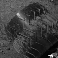
|
Posted by: jmknapp Sep 5 2012, 11:02 AM
Some of those rocks are sharp... owie owie ouch! If real, hope it's from landing & not daily wear and tear.
A few detail anaglyphs from sol 29:
|
|
|
Posted by: meraero Sep 5 2012, 02:26 PM
I've been searching all morning for a documentary I saw recently about curiosity that starts with some artful shots of her twin in the shed at the JPL Mars yard. The close-up footage showed her wheels with large "tears" in them. When I saw that dent, that was the first thing I thought of. Anyone know what documentary I'm talking about? I think we are going to see a some very beat-up wheels in two years.
Posted by: mhoward Sep 5 2012, 03:04 PM
Nice tracks on sol 29
|
Posted by: ugordan Sep 5 2012, 03:49 PM
BBC Horizon - Mission To Mars?
Posted by: jmknapp Sep 5 2012, 04:04 PM
Nice mosaic. Could I ask what algorithm you use to warp the individual navcam frames so that they more or less fit together?
Posted by: mhoward Sep 5 2012, 04:15 PM
I'm actually not warping them yet; for the moment they're just projected as a straightforward rectangle (or actually a grid). If you look really carefully, they're distorted and don't match up as well as they might. Correcting for the actual camera model will be one of the next things to try (Even the literature mentions the mathematics of that is complicated. It's certainly complicated for me.)
Posted by: meraero Sep 5 2012, 04:26 PM
That's the one! Look at the wheels starting around 6:55 min in
http://www.youtube.com/watch?v=VJxmuSrqn0k
Screen grab...
http://i1165.photobucket.com/albums/q593/meraero/MSLLanding/Screenshot2012-09-05at121651PM.png
Posted by: Ant103 Sep 5 2012, 06:06 PM
Sol 29 Navcam pan. I love to see these tracks, going to the horizon.
http://www.db-prods.net/marsroversimages/Curiosity/2012/Sol29_pano.jpg
Hmm
Are we there yet ? Are we there yet ? Are we [
]
Posted by: elakdawalla Sep 5 2012, 06:23 PM
That drive was apparently the last act of Intermission; CAP 2 started sol 30. I've http://www.unmannedspaceflight.com/index.php?showtopic=7454.
Posted by: Ant103 Sep 5 2012, 06:39 PM
A special prod for this panorama .
|
Posted by: elakdawalla Sep 5 2012, 06:48 PM
Folks, I am attempting to very briefly summarize each sol's activities on http://www.planetary.org/explore/space-topics/space-missions/curiosity-sols.html. The mission is getting better at posting http://mars.jpl.nasa.gov/msl/news/whatsnew/index.cfm, but my information for the first part of intermission is pretty sketchy. I'd appreciate it if people could email/PM with any corrections.
Speaking of updates, there's a teleconference planned for tomorrow.
Posted by: RoverDriver Sep 5 2012, 07:48 PM
We didn't notice any on the first drive. I actually see a couple of dents.
Paolo
Posted by: djellison Sep 5 2012, 07:55 PM
Regarding wheel damage....the VSTB (test rover) is effectively 3x too heavy for its wheels....it's eaten its way thru a set already and they've been replaced with an extra beefy set.
There will be dings and dents on the wheels on Mars, but I wouldn't expect anything as bad as is in that video.
Posted by: jmknapp Sep 5 2012, 08:16 PM
Hmmm... seems like some of the panorama-makers here might be doing that--wonder if it's the full CAHVOR model or some approximation, or maybe some canned software.
Posted by: Joffan Sep 5 2012, 08:23 PM
There will be dings and dents on the wheels on Mars, but I wouldn't expect anything as bad as is in that video.
I thought that initially too - that the gravity would be relatively high - but isn't the test (driving) rover specially lightened to compensate for that? I'm sure I remember reading that somewhere. It would make sense, especially for slip tests which could be influenced in either direction by not matching the ground force.
My second thought was that the team will always put the test vehicle through much tougher circumstances than they would usually expect for Curiosity herself.
Posted by: markril Sep 5 2012, 08:26 PM
Here's an interpretation of a MARDI image from sol 25:
|
Original:
http://mars.jpl.nasa.gov/msl/multimedia/raw/?s=25&camera=MARDI
Mark
Posted by: mhoward Sep 5 2012, 08:26 PM
I was referring to the CAHVOR model (CAHVORE for the Hazcams). If CAHVOR is used in any of the off-the-shelf panorama tools I'm not aware of it, although I could be wrong.
Edit: Maybe someone has taken the CAHVOR parameters and worked out parameters that work with the existing mosaicking tools? If so, that would be interesting to hear about. If I've heard about it in the past eight years with MER, I've forgotten.
Posted by: fredk Sep 5 2012, 08:44 PM
But were the parts of the wheels facing down during landing (so perhaps dinged) imaged in the early days? In other words, do you expect to have seen any landing-dings?
Presumably we can check the rotation phase of each wheel in the pre-first-drive images, and figure out whether these dings were facing down during landing...
Posted by: meraero Sep 5 2012, 09:19 PM
There will be dings and dents on the wheels on Mars, but I wouldn't expect anything as bad as is in that video.
No argument here. I just don't ever recall seeing any dings on the earth-bound MER wheels in all of their testing (tread scuffing perhaps). Whether due to scaling effects, wheel design or both, it seems we should expect to see more visible wear on the wheels than any seen on the MER rovers.
Posted by: djellison Sep 5 2012, 09:35 PM
The Scarecrow rover yes.
http://www.flickr.com/photos/planetaryblog/7197573662/
VSTB, no.
http://photojournal.jpl.nasa.gov/catalog/PIA15876
(Some of my own photos of the VSTB are here : http://dougellison.smugmug.com/Machines/Mars-Yard-2012/23370887_zGB3Dr#!i=1887244649&k=ZnpCztC )
Posted by: RoverDriver Sep 5 2012, 10:53 PM
Presumably we can check the rotation phase of each wheel in the pre-first-drive images, and figure out whether these dings were facing down during landing...
On the first drive we rotated teh wheels 180 deg and took a mid-drive image exactly to inspect the area that was facing downward upon landing. I don't recall seeing any dents.
Paolo
Posted by: ToSeek Sep 6 2012, 12:28 AM
Just announced one for tomorrow (Thursday), 10 am PDT, 1 pm EDT: http://www.jpl.nasa.gov/news/news.php?release=2012-276&cid=release_2012-276&msource=12276
Posted by: Vanden Sep 6 2012, 12:33 AM
I wait for the images (bayer/lossless) without the problem of JPEG compression ...
De-bayer/lossy are very good.
http://vandenk.free.fr/100mm-Sol21.jpg
Posted by: eoincampbell Sep 6 2012, 01:41 AM
Those dunes are starting to look majestic, can't wait for a real good view after Glenelg...
Posted by: Joffan Sep 6 2012, 03:08 AM
Posted by: vikingmars Sep 6 2012, 09:08 AM
.Wow, Ant103 ! WOW ! WOW ! This image is just beautifully impressive ! Thanks a lot for sharing it with us !

Posted by: jmknapp Sep 6 2012, 09:10 AM
That would be a start--and then a perspective transformation for each tile from there?
I was playing with the CAHVOR models given for each camera & it seems the distortion is not huge for mastcam & navcam, e.g., ftp://naif.jpl.nasa.gov/pub/naif/MSL/kernels/ik/msl_ml_20120731_c03.ti:

|
So the bulk of the warpage would be further transformations like perspective (suggested by http://www.google.com/url?sa=t&rct=j&q=&esrc=s&source=web&cd=1&cad=rja&ved=0CCIQFjAA&url=http%3A%2F%2Fgraphics.cs.cmu.edu%2Fcourses%2F15-463%2F2004_fall%2Fwww%2FLectures%2Fmosaic.ppt&ei=xGBIUOXbFeHn0gG1pYD4BA&usg=AFQjCNHJVkmLYc7wldPs74MAYF4VVdnU1Q&sig2=mZKbaqxwJJiYX_3dIP5kAg and ch. 9 of http://szeliski.org/Book/drafts/SzeliskiBook_20100903_draft.pdf).
You mention existing mosaicing tools?
Posted by: kenny Sep 6 2012, 10:27 AM
Of more immediate interest than the dunes, I'm seeing what looks like wind-scoured bedrock in the middle distance.
Posted by: mhoward Sep 6 2012, 12:46 PM
Referring to things like PTGui, Hugin, Autostitch, etc., which most people are using to produce mosaics and panoramas.
The distortion is not huge for Navcam but it is significant. I imagine the distortion is much less for Mastcam, as it was for Pancam.
What I'm after from CAHVOR is not just a fix for the distortion (though I want that) but the correction for small factors in the rotation/tilt of the camera in its housing. Tools like PTGui etc. are good at automatically working around stuff like that, because they're designed for people taking pictures in a wide range of conditions (that's diplomatic-speak for 'they have to deal with sloppy camera work all the time'). But the rovers do rather exact camera work, so we can project the images more precisely ourselves if we really want or need to. For example, I'm trying to approximate the mast pointing metadata which we don't have access to, by manually lining up Navcam images in space; when doing that, the very slight rotation of each Navcam image becomes a nuisance, as my placement of images tends to drift downward over the course of a full 360º panorama. That's one reason I'd like to get the camera model fully figured out.
Yes, that's how MMB currently works (without the CAHVOR part), and that's the idea. The mosaic I posted is a screenshot of a projection running in realtime.
Posted by: jmknapp Sep 6 2012, 01:42 PM
FWIW, this is what I get for navcam left A frame (gray) relative to the rover frame (black), using the CAHVOR parameters:

|
So there's a little tilt along with minor distortion, assuming no bugs. I used the method in this paper, specifically in section 2.1: http://shoreline.eng.ohio-state.edu/publications/jgr109_e04004.pdf.
Posted by: fredk Sep 7 2012, 06:08 PM
Navcam anaglyph from sol26 - lovely place to go for a drive:

|
Posted by: stewjack Sep 7 2012, 09:26 PM
For those without red/green glasses etc. A flicker gif.
As fredk's anaglyph demonstrated - It looks like we climbed up a slope!

|
Posted by: RoverDriver Sep 7 2012, 09:38 PM
It was a small hump we climbed and descended on Sol 29. It was visible in the NAVCAM from Sol 24 and 26 as well as the HiRISE DEM. I have to begin using flicker GIFs more often.
Paolo
Posted by: Joffan Sep 7 2012, 11:38 PM
As fredk's anaglyph demonstrated - It looks like we climbed up a slope!
From the frequent changes in wheel direction, evidenced by the tread patterns, it looks like we danced up a slope.
Posted by: RoverDriver Sep 8 2012, 12:27 AM
I haven't looked closely at the telemetry but this drive used blind go_to_waypoint and it is possible that integrating teh IMU data with the wheel odometry teh vehicle was correcting minor misalignments with the goal location. There are parameters we can set to avoid this behavior.
Paolo
Posted by: jmknapp Sep 8 2012, 01:50 AM
A stitch of three NAVCAM images of the deck, sol 29:

|
Posted by: Ant103 Sep 8 2012, 03:00 PM
Sol 29 Navcam updated and completed
http://www.db-prods.net/marsroversimages/Curiosity/2012/Sol29_pano.jpg
Posted by: centsworth_II Sep 9 2012, 04:49 PM
Look Ma! No lander!

|
http://www.jpl.nasa.gov/spaceimages/details.php?id=PIA16141
Posted by: fredk Sep 9 2012, 05:13 PM
Little bright squiggle back near the landing site from sol 20:

|
Posted by: ilbasso Sep 9 2012, 06:32 PM
Right after the MSL landing, I thought what it would be like for some Martian wanderer who just happened upon the MSL landing site. You'd see these tracks suddenly stopping here and the other end stretching off into the distance. What made these, and where did it come from, or where did it go? Was it 'raptured' away?
Posted by: climber Sep 10 2012, 12:43 AM
|
|
I guess you remember we sew such "artificial" device back in 2004, can't remember which MER it was. So, I guess it comes from Curiosity.
Posted by: morganism Sep 10 2012, 11:41 PM
kapton tape, or part of the electrical umbilical sheath?
Posted by: atomoid Sep 11 2012, 12:29 AM
i think you're referring to Oppys sighting of http://marsrovers.jpl.nasa.gov/gallery/all/1/p/002/1P128372948EFF0200P2211R2M1.JPG on the first few sols (though i think theres a better pic in another cam), i think that vanished like the Cheshire cat at some point if i recall, ..perhaps after shedding some http://marsrovers.jpl.nasa.gov/gallery/all/1/m/019/1M129869847EFF0338P2953M2M1.JPG (under big spherule at upper right)
Posted by: climber Sep 11 2012, 01:31 AM
Yep rabbit it was, thanks.
Posted by: paraisosdelsistemasolar Sep 11 2012, 03:18 PM
Nice outcrop on Sol 27 It seems like a clastic rock.
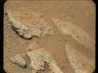
|
Posted by: climber Sep 11 2012, 03:48 PM
It's remarkable how clean is (the downwind?) side of both rock and gravels. I don't recall such (big) difference in other landing sites.
Lot of gravels, BTW. Is that a sign of alluvial place or not at all?
Posted by: fredk Sep 11 2012, 04:00 PM
Cute rock cairn from sol20, near the landing site:

|
BTW, this is the right thread for both these images - I'm noticing images showing up in wrong threads.
Posted by: paraisosdelsistemasolar Sep 11 2012, 04:07 PM
Lot of gravels, BTW. Is that a sign of alluvial place or not at all?
At least I can't know exactly what processes made this rocks we are seeing in the image. We need close-up images for that. From that point of view it seems like a basaltic tuff but it also could be a detritic rock, so it's kind of difficult to guess at this moment how this rock was formed. I hope MAHLI starts to take images of the rocks soon
Posted by: Ondaweb Sep 12 2012, 01:05 AM
To me it looks more like a balancing rock than a cairn! Does a 2d image show something supporting the left side of the high rock?
Posted by: Ant103 Sep 12 2012, 10:17 AM
Is this some kind of pharaos artifact ?
Posted by: jmknapp Sep 12 2012, 12:12 PM
Maybe it's significant that there's a telecon scheduled today, and the fullframe mastcam sol 27 images just appeared on the public site yesterday?
Here's an anaglyph of the outcrop:
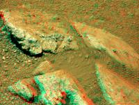
|
The raw color image: http://mars.jpl.nasa.gov/msl-raw-images/msss/00027/mcam/0027MR0129005000E1_DXXX.jpg
Seems like the rocks are covered with a layer of dust on the right-facing sides--would that be the "lee" side? I.e., dust wouldn't collect on the windward side.
Posted by: fredk Sep 12 2012, 02:19 PM
Our first M100 pair with a decent baseline, from sols 19 and 25:
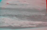
|
Posted by: climber Sep 12 2012, 04:55 PM
You don't expect they'll announce proof of water on Mars, don't you?
Posted by: jmknapp Sep 12 2012, 05:17 PM
You mean extant water at the site? Or strong indication that they're seeing water-lain deposits?--maybe that would rate a full-on press conference. But it'd be fun if they have something sciencey to say about what they're seeing in these shots. Who knows though, could be a engineering status report on MAHLI and the arm.
Posted by: climber Sep 12 2012, 05:23 PM
Would be nice, eh? I was just making a comment we enjoy here saying they've (again) discovered water on Mars. Frankly I don't expect a big announcement so early in the mission unless we all missed something BIG here at UNMSF.
Posted by: fredk Sep 12 2012, 05:48 PM
I'd say definitely engineering status report. (But then I've just seen the new press release images...)
Posted by: charleski Sep 12 2012, 06:34 PM
Leo Enright just asked the question that's been in my mind for a week now.
I think it's going to be a while before we get proper scientific interpretations coming out, even for mundane stuff - obviously everything will need to be thoroughly checked before being announced. The first set of really interesting stuff is waiting at Glenelg, anyway.
[Edit]: Also, compare the picture of the penny, with the ones shown http://www.astrobio.net/index.php?option=com_retrospection&task=detail&id=4554 (http://www.astrobio.net/images/galleryimages_images/Gallery_Image_8817.jpg). That penny was nice and shiny when it left Earth, has it picked up a layer of fine dust or has a month of exposure been enough to erode the surface?
Actually - looking at the other recent MAHLI http://mars.jpl.nasa.gov/msl-raw-images/msss/00034/mhli/0034MH0045001000E1_DXXX.jpg shows dust packing the gap between the penny and the target surround, so it's probably just a layer of dust, though I wonder how abrasive this stuff is.
Posted by: jmknapp Sep 12 2012, 07:05 PM
Enright does it again--Joy Crisp was pretty coy about it, saying that science team is "actively debating what they're seeing in those textures, uh, they are excited about what they've seen, but we're not ready yet to say what it means." Another questioner tried to press for "some of the ideas that the science team is kicking around about what they're seeing there." Crisp replied again saying they're not ready to talk about it yet, "but probably next week we will, so stay tuned" and "we don't want to stick our necks out yet."
Leo also asked about another issue that I wondered about--that since MEX is over the horizon for hours sometimes, do they plan to take advantage of its communications capability. The answer from Jennifer Trosper was basically that there are currently no plans use MEX as a data link, & that one MRO pass alone recently resulted in 500MB of data.
Posted by: mcaplinger Sep 12 2012, 07:11 PM
It may be visible but it's far away and inverse-square law makes the data rate uselessly low, I'm guessing.
Posted by: elakdawalla Sep 12 2012, 09:08 PM
I had asked Edgett if the red stuff surrounding the penny was dust and he said not. "The red stuff -- as with the red inside the MAHLI lens in those Mastcam images -- that is the RTV adhesive."
Posted by: charleski Sep 12 2012, 10:17 PM
That would make sense, and I found a http://www.jpl.nasa.gov/images/msl/20120207/curious20120207-full.jpg that clearly shows the adhesive in the pre-flight pictures. It's definitely lost its shininess, though, and there appears to be a void from 8-12o'clock that's certainly not there pre-flight. The uneven distribution is why I jumped to the conclusion that it was fine, wind-blown dust, but now I wonder whether the adhesive has been scoured away. Going by the shadows the light is coming from approximately 10 o'clock, so maybe this is just a trick of the light?
[Edit]Actually, after looking at it close-up and comparing with http://www.jpl.nasa.gov/images/msl/20120207/pia15285-43.jpg I think that, yes, the appearance of the surround is mostly just a trick of the light. But there is an area just to the right of the 'S' where there appears to have been a small void in the adhesive pre-flight and the roof of the void has now been removed.

|
Posted by: EdTruthan Sep 13 2012, 07:56 PM
Anaglyph from photos taken during this CAP so I figured they ought to go in this thread. I used the three partial MC100 BW frames from Sol 25 (left eye), and corresponding color frames from Sol 19 (right eye), so pretty decent baseline separation. I separated them a bit more than usual as it seems the varying depths of field are easier on the eye once you're locked on in stereo. The soft looking layers in the rounded fish hook shaped hollow in the foreground below the hard caprock are pretty interesting. Though the thumbnail looks pink, once in glasses it's quite natural looking...

|
Posted by: MarkL Sep 13 2012, 08:14 PM
Anyone know if there is a place to find the archived video press briefings? I missed yesterday's. Surprise surprise, I was working.
Posted by: maschnitz Sep 13 2012, 08:29 PM
All the news conferences are archived on UStream:
http://www.ustream.tv/nasajpl
Pointers to individual ones are on JPL's site:
http://mars.jpl.nasa.gov/msl/news/whatsnew/
Each individual announcement contains pointers to the visuals, like this last one; but I suspect this URL is just for the latest:
http://www.nasa.gov/mission_pages/msl/telecon/index.html
Generally, the visuals show up archived either in the raws, the vetted "Images" section, in JPL's Photojournal, or in some combination of the three.
http://mars.jpl.nasa.gov/msl/multimedia/raw/
http://mars.jpl.nasa.gov/msl/multimedia/images/
http://photojournal.jpl.nasa.gov/targetFamily/Mars?subselect=Mission%3AMars+Science+Laboratory+%28MSL%29%3A
Posted by: mcaplinger Sep 13 2012, 08:44 PM
I think this is an artifact of somewhat different viewing angle and quite different lighting direction and type of lighting. That RTV would be pretty hard to remove even if you tried to dig it out with an X-acto knife or a dental pick.
Also, the ground photo is the unrealistic saturated color of a typical lower-end commercial camera.
Posted by: charleski Sep 14 2012, 09:43 AM
Unfortunately NASA/JPL stripped the EXIF so we can't say what camera they used.
I suppose we'll get other images of the calibration targets later on, so we'll be able to see what it looks like with different lighting angles. The calibration targets are stowed quite low down, so probably received a similar covering of muck to that seen on the front hazcam covers (maybe more, since it's pointed towards http://www.jpl.nasa.gov/images/msl/20120906/pia16146-43.jpg, though the dust boundary seen on the lower part of the carrier suggests that something was partially covering it from the effects of the jets). We've already had one instrument (the REMS boom) suffer damage from environmental factors, so it might be useful to see what other data can be found about the forces that were experienced.
Posted by: chris Sep 14 2012, 12:39 PM
http://www.ustream.tv/nasajpl
Pointers to individual ones are on JPL's site:
http://mars.jpl.nasa.gov/msl/news/whatsnew/
Each individual announcement contains pointers to the visuals, like this last one; but I suspect this URL is just for the latest:
http://www.nasa.gov/mission_pages/msl/telecon/index.html
Generally, the visuals show up archived either in the raws, the vetted "Images" section, in JPL's Photojournal, or in some combination of the three.
http://mars.jpl.nasa.gov/msl/multimedia/raw/
http://www.nasa.gov/mission_pages/msl/telecon/index.html
http://photojournal.jpl.nasa.gov/targetFamily/Mars?subselect=Mission%3AMars+Science+Laboratory+%28MSL%29%3A
Admins, could we please add this to the sticky MSL FAQs and USEFUL DOCUMENTS topic? DONE! THANKS!
Posted by: maschnitz Sep 14 2012, 04:56 PM
Thanks astro0, and chris.
One minor correction: I made a cut-and-paste error. The second to last URL should be this, not the telecon link:
http://mars.jpl.nasa.gov/msl/multimedia/images/
Could an admin make the correction in the sticky? DONE. Thanks again!
Posted by: mcaplinger Sep 14 2012, 05:35 PM
It was a Nikon D3 at f/5.7, ISO 200, 70mm focal length, pattern metering mode, and the flash was fired.
At over $3K list, I guess I wouldn't call that a "lower-end commercial camera" but I stand by my comments about the color accuracy (sorry, Nikon.)
Powered by Invision Power Board (http://www.invisionboard.com)
© Invision Power Services (http://www.invisionpower.com)