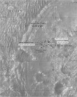
Perseverance Route Map |

  |
Perseverance Route Map |
 Apr 9 2021, 07:05 AM Apr 9 2021, 07:05 AM
Post
#61
|
||
|
Solar System Cartographer  Group: Members Posts: 10151 Joined: 5-April 05 From: Canada Member No.: 227 |
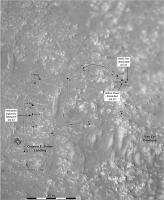
Another drive on sol 48, getting closer to the overlook.
Phil
-------------------- ... because the Solar System ain't gonna map itself.
Also to be found posting similar content on https://mastodon.social/@PhilStooke Maps for download (free PD: https://upload.wikimedia.org/wikipedia/comm...Cartography.pdf NOTE: everything created by me which I post on UMSF is considered to be in the public domain (NOT CC, public domain) |
|
 |
 
|
|
|
Apr 10 2021, 07:16 AM
Post
#62
|
||
|
Solar System Cartographer Group: Members Posts: 10151 Joined: 5-April 05 From: Canada Member No.: 227 |
Sol 49 - closer to the overlook, but not yet at the exact point denoted earlier. I don't suppose they really have to worry about being exactly on it. This location comes from the Hazcam projection I just posted in the Early Drives thread.
Phil
-------------------- ... because the Solar System ain't gonna map itself.
Also to be found posting similar content on https://mastodon.social/@PhilStooke Maps for download (free PD: https://upload.wikimedia.org/wikipedia/comm...Cartography.pdf NOTE: everything created by me which I post on UMSF is considered to be in the public domain (NOT CC, public domain) |
|
|
|
|
|
|
Apr 13 2021, 06:13 PM
Post
#63
|
||
 Member Group: Members Posts: 349 Joined: 20-June 07 From: Slovenia Member No.: 2461 |
Sol 52 update. Flight set up (almost?) complete. |
|
|
|
|
|
|
Apr 14 2021, 12:10 AM
Post
#64
|
||
|
Solar System Cartographer Group: Members Posts: 10151 Joined: 5-April 05 From: Canada Member No.: 227 |
And my map for sol 52.
Phil
-------------------- ... because the Solar System ain't gonna map itself.
Also to be found posting similar content on https://mastodon.social/@PhilStooke Maps for download (free PD: https://upload.wikimedia.org/wikipedia/comm...Cartography.pdf NOTE: everything created by me which I post on UMSF is considered to be in the public domain (NOT CC, public domain) |
|
|
|
|
|
|
Apr 17 2021, 07:55 PM
Post
#65
|
|
|
Member Group: Members Posts: 248 Joined: 25-February 21 From: Waltham, Massachussetts, U.S.A. Member No.: 8974 |
I had been away from my qgis setup. Here my update for sol 59, with new labels:
 and the full map: 
-------------------- --
Andreas Plesch, andreasplesch at gmail dot com |
|
|
|
|
Apr 24 2021, 03:46 AM
Post
#66
|
|
|
Member Group: Members Posts: 248 Joined: 25-February 21 From: Waltham, Massachussetts, U.S.A. Member No.: 8974 |
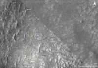
I tried my best to register the high resolution helicopter overhead perspective, using about 40 control points:
 The helicopter lens seems to be wide angle, fish-eye, with heavy distortion away from the center. So I used rubber sheeting ( thin plate spline ) to generate a map:  Since I did not use the tracks for referencing, the good match between the actual and simulated tacks shows that referencing of the rocks went well, and that the base map was also well registered. -------------------- --
Andreas Plesch, andreasplesch at gmail dot com |
|
|
|
|
Apr 26 2021, 02:50 AM
Post
#67
|
|
|
Member Group: Members Posts: 248 Joined: 25-February 21 From: Waltham, Massachussetts, U.S.A. Member No.: 8974 |
I registered the second oblique helicopter view along the flight zone, clipping the highly distorted, more distant view. Here is a composite map of the flight zone which Ingenuity traversed to today, probably for about 50m.

-------------------- --
Andreas Plesch, andreasplesch at gmail dot com |
|
|
|
|
Apr 26 2021, 11:19 PM
Post
#68
|
||
|
Solar System Cartographer Group: Members Posts: 10151 Joined: 5-April 05 From: Canada Member No.: 227 |
A short drive which I was not expecting on sol 65, pointed out by Paul in the other thread... Using Navcams I find a location hastily mapped here. I will fix up the base later.
Phil
-------------------- ... because the Solar System ain't gonna map itself.
Also to be found posting similar content on https://mastodon.social/@PhilStooke Maps for download (free PD: https://upload.wikimedia.org/wikipedia/comm...Cartography.pdf NOTE: everything created by me which I post on UMSF is considered to be in the public domain (NOT CC, public domain) |
|
|
|
|
|
|
Apr 27 2021, 01:06 PM
Post
#69
|
|
|
Member Group: Members Posts: 248 Joined: 25-February 21 From: Waltham, Massachussetts, U.S.A. Member No.: 8974 |
For what it's worth I registered the third helicopter perspective (to the west) to the map:
 Here the larger flight zone: 
-------------------- --
Andreas Plesch, andreasplesch at gmail dot com |
|
|
|
|
Apr 27 2021, 01:27 PM
Post
#70
|
|
|
Member Group: Members Posts: 240 Joined: 18-July 06 Member No.: 981 |
QUOTE (Andreas Plesch @ Apr 27 2021, 01:06 PM)  For what it's worth I'd say its worth a lot Andreas. Thanks. |
|
|
|
|
Apr 27 2021, 07:37 PM
Post
#71
|
|
|
Member Group: Members Posts: 248 Joined: 25-February 21 From: Waltham, Massachussetts, U.S.A. Member No.: 8974 |
Thanks. Since I used rocks and pavement patterns to register the images to the EDL basemap, it was an interesting exercise to get to know a large number of these features more closely in the vicinity of the airfield, and some larger ones in the distance. With real photogrammetry and knowledge of the lens and camera orientation one could do a better job but this is pretty good on a cm scale.
-------------------- --
Andreas Plesch, andreasplesch at gmail dot com |
|
|
|
|
Apr 28 2021, 01:06 AM
Post
#72
|
|
|
Member Group: Members Posts: 248 Joined: 25-February 21 From: Waltham, Massachussetts, U.S.A. Member No.: 8974 |
Updated maps to sol66:
 full map: 
-------------------- --
Andreas Plesch, andreasplesch at gmail dot com |
|
|
|
|
Apr 28 2021, 02:25 AM
Post
#73
|
|
 Member Group: Members Posts: 226 Joined: 13-October 09 From: Olympus Mons Member No.: 4972 |
Just to think, we are mapping the first controlled flight paths on Mars!
-------------------- "Thats no moon... IT'S A TRAP!"
|
|
|
|
|
Apr 28 2021, 03:38 AM
Post
#74
|
||
|
Solar System Cartographer Group: Members Posts: 10151 Joined: 5-April 05 From: Canada Member No.: 227 |
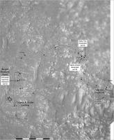
I will have a map of flight paths eventually! For now an update after a short drive on sol 66, well behind Andreas in getting to this. I am reverting to a smaller scale map until I have a better sense of where we are going.
The offset between real positions and the JPL map continues - it's about 1 rover length. The maps on here are all corrected. Phil
-------------------- ... because the Solar System ain't gonna map itself.
Also to be found posting similar content on https://mastodon.social/@PhilStooke Maps for download (free PD: https://upload.wikimedia.org/wikipedia/comm...Cartography.pdf NOTE: everything created by me which I post on UMSF is considered to be in the public domain (NOT CC, public domain) |
|
|
|
|
|
|
Apr 28 2021, 08:21 PM
Post
#75
|
|
|
Member Group: Members Posts: 248 Joined: 25-February 21 From: Waltham, Massachussetts, U.S.A. Member No.: 8974 |
A mosaic of the four Ingenuity images, registered to a base map:
 I used Thomas' straightened version (thanks !) hoping that it would behave favorably in the distance but I had to crop anyways. (In fact, I think it made interpolating between control points perhaps less robust than the original would have.) -------------------- --
Andreas Plesch, andreasplesch at gmail dot com |
|
|
|
|

|
Lo-Fi Version | Time is now: 26th April 2024 - 06:14 PM |
|
RULES AND GUIDELINES Please read the Forum Rules and Guidelines before posting. IMAGE COPYRIGHT |
OPINIONS AND MODERATION Opinions expressed on UnmannedSpaceflight.com are those of the individual posters and do not necessarily reflect the opinions of UnmannedSpaceflight.com or The Planetary Society. The all-volunteer UnmannedSpaceflight.com moderation team is wholly independent of The Planetary Society. The Planetary Society has no influence over decisions made by the UnmannedSpaceflight.com moderators. |
SUPPORT THE FORUM Unmannedspaceflight.com is funded by the Planetary Society. Please consider supporting our work and many other projects by donating to the Society or becoming a member. |
|