Chang'e 3 landing and first lunar day of operations, Including landing site geology and localization |

  |
Chang'e 3 landing and first lunar day of operations, Including landing site geology and localization |
 Dec 15 2013, 12:36 AM Dec 15 2013, 12:36 AM
Post
#106
|
|
 Senior Member  Group: Members Posts: 1419 Joined: 26-July 08 Member No.: 4270 |
The second image I saw on FB recently, but the third image is new to me. Thanks for that link.
-------------------- -- Hungry4info (Sirius_Alpha)
|
 |
 
|
|
Dec 15 2013, 12:50 AM
Post
#107
|
|
|
Member Group: Members Posts: 378 Joined: 21-April 05 From: Portugal Member No.: 347 |
Those pictures are in somewhat higher quality here:
http://news.xinhuanet.com/english/photo/20...132968376_5.htm -------------------- _______________________
www.astrosurf.com/nunes |
|
|
|
|
Dec 15 2013, 02:00 AM
Post
#108
|
||
|
Solar System Cartographer Group: Members Posts: 10151 Joined: 5-April 05 From: Canada Member No.: 227 |
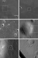
Going from a LROC-WAC mosaic to a NAC frame to a descent camera mosaic (from 4th Rock... welcome back!) - a locator guide to the site.
Phil
-------------------- ... because the Solar System ain't gonna map itself.
Also to be found posting similar content on https://mastodon.social/@PhilStooke Maps for download (free PD: https://upload.wikimedia.org/wikipedia/comm...Cartography.pdf NOTE: everything created by me which I post on UMSF is considered to be in the public domain (NOT CC, public domain) |
|
|
|
|
|
|
Dec 15 2013, 02:39 AM
Post
#109
|
||
|
Solar System Cartographer Group: Members Posts: 10151 Joined: 5-April 05 From: Canada Member No.: 227 |
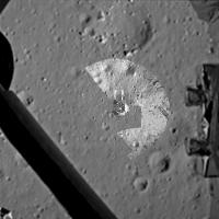
And this is 4th Rock's mosaic with additions from one of the TV screenshots posted on NasaSpaceFlight. It is an overhead projection of the initial rover image mosaic, for planning purposes, superimposed with a lander model. This all took a bit of fudging, but it's a start at a site map.
Phil
-------------------- ... because the Solar System ain't gonna map itself.
Also to be found posting similar content on https://mastodon.social/@PhilStooke Maps for download (free PD: https://upload.wikimedia.org/wikipedia/comm...Cartography.pdf NOTE: everything created by me which I post on UMSF is considered to be in the public domain (NOT CC, public domain) |
|
|
|
|
|
|
Dec 15 2013, 06:25 AM
Post
#110
|
|
|
Senior Member Group: Members Posts: 2920 Joined: 14-February 06 From: Very close to the Pyrénées Mountains (France) Member No.: 682 |
So, last picture is a square of about 100m x 100m?
-------------------- |
|
|
|
|
Dec 15 2013, 10:40 AM
Post
#111
|
|||
 Member Group: Members Posts: 547 Joined: 1-May 06 From: Scotland (Ecosse, Escocia) Member No.: 759 |
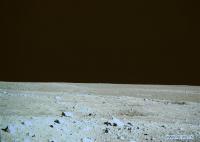
This high res image seems to be from the Mast Camera on the lander. It shows the far side of the crater in front of the Rover, and the landscape to the north.
It was taken later than the one below, as the sun is higher and shadows are a little shorter. Its location is indicated by the box below.
This low res image below shows the area north of the Lander before the Rover was deployed. Yellow box inset is the location of the high res.
|
||
|
|
|
||
|
Dec 15 2013, 11:22 AM
Post
#112
|
|
 Senior Member Group: Members Posts: 1729 Joined: 3-August 06 From: 43° 35' 53" N 1° 26' 35" E Member No.: 1004 |
A more complete descent video. But I think we still have not seen the complete sequence
http://www.youtube.com/watch?v=lA__4SnHqH8 |
|
|
|
|
Dec 15 2013, 11:37 AM
Post
#113
|
|
 Member Group: Members Posts: 495 Joined: 12-February 12 Member No.: 6336 |
Congratulations to those who work on the Chinese space program!
And thank you Hungry4info for identifying the landing site. Now lets see what a lunar rabbit can achieve! 
|
|
|
|
|
Dec 15 2013, 02:13 PM
Post
#114
|
|
 Senior Member Group: Members Posts: 3419 Joined: 9-February 04 From: Minneapolis, MN, USA Member No.: 15 |
All right -- ship in port, Captain's gig launched. Way to go!
Congrats to the Chinese Space Agency for grabbing the brass ring on their first try. -the other Doug -------------------- The trouble ain't that there is too many fools, but that the lightning ain't distributed right. -Mark Twain
|
|
|
|
|
Dec 15 2013, 02:29 PM
Post
#115
|
|
|
Member Group: Members Posts: 547 Joined: 1-May 06 From: Scotland (Ecosse, Escocia) Member No.: 759 |
The rover is due to pass around the east (sunlit) side of the lander in a drive of 10 meters, stopping at 5 different locations for mutual photography.
CNTV says: The 10 meter walk from the lander will take Yutu about two hours due to the bumpy and uneven surface of the Moon. The entire process of capturing five images will take up to 20 hours to complete. Yutu will take two pictures of the front side of ChangE 3. This is the side where the Chinese national flag is painted. One of the pictures will be taken from ten meters away, while the other will be clicked from a distance of 18 meters. The moving path designed for Yutu is a half circle. Pictures will be taken firstly from the back of the lander, and then the side and then the front." CNTV story and video of Yutu photography |
|
|
|
|
Dec 15 2013, 02:57 PM
Post
#116
|
|
|
Member Group: Members Posts: 154 Joined: 21-April 05 From: Rochester, New York, USA Member No.: 336 |
Live coverage now on - but you need a plugin (at least I did):
http://english.cntv.cn/special/lunarmissio...102945984341204 |
|
|
|
|
Dec 15 2013, 03:11 PM
Post
#117
|
|
|
Senior Member Group: Members Posts: 3419 Joined: 9-February 04 From: Minneapolis, MN, USA Member No.: 15 |
A couple of observations about the imaging thus far:
First, the images from Yutu's mast camera seem a little over-saturated. At least, the brightest elements in the images (the rock faces reflecting sunlight right back into the camera) look rather over-saturated to me. Second, the color rendition from the lander's panoramic camera seems to be biased towards a very brown image, while the rover's color camera is registering more of the expected grayish coloration of the regolith, almost trending towards a slight greenish tinge. Interestingly, these are the same range of color biases that were achieved from the various color film stocks used during Apollo. It took until the later flights for the photo processors to achieve a consistent representation of the grayish lunar regolith; this shows how difficult it can be to get good, representative color from the lunar surface. I wonder if the mission controllers will be adjusting the color balances and saturation in the released images as time goes on? Also, looking forward to more of the full video feed from Yutu. That was pretty impressive from the quick flashes we saw during the rover deployment. -the other Doug -------------------- The trouble ain't that there is too many fools, but that the lightning ain't distributed right. -Mark Twain
|
|
|
|
|
Dec 15 2013, 03:11 PM
Post
#118
|
|
|
Solar System Cartographer Group: Members Posts: 10151 Joined: 5-April 05 From: Canada Member No.: 227 |
If you look back to post 270 (page 18) in this thread (http://www.unmannedspaceflight.com/index.p...3105&st=255) I posted a Clementine false colour map of the landing region, showing 'blue' and 'yellow' lava flows.
We landed in the blue unit, but only a few km from the boundary. That boundary shows up as an albedo boundary in my locator sequence as well. So if Yutu drives north they should be able to cross the contact between two flows, getting compositional data for both and using the radar to map the depth of the blue unit as they go. There is also a mare ridge here, so its structure may be investigated. It could be a very scientifically productive site. Phil -------------------- ... because the Solar System ain't gonna map itself.
Also to be found posting similar content on https://mastodon.social/@PhilStooke Maps for download (free PD: https://upload.wikimedia.org/wikipedia/comm...Cartography.pdf NOTE: everything created by me which I post on UMSF is considered to be in the public domain (NOT CC, public domain) |
|
|
|
|
Dec 15 2013, 03:22 PM
Post
#119
|
||
|
Senior Member Group: Members Posts: 1729 Joined: 3-August 06 From: 43° 35' 53" N 1° 26' 35" E Member No.: 1004 |
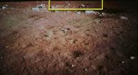
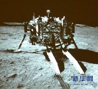
this was posted on facebook a few minutes ago
Attached thumbnail(s)
|
|
|
|
|
|
|
Dec 15 2013, 03:38 PM
Post
#120
|
|
|
Junior Member Group: Members Posts: 64 Joined: 15-June 12 From: Hong Kong Member No.: 6419 |
QUOTE (Paolo @ Dec 15 2013, 11:22 PM)  this was posted on facebook a few minutes ago Note that it appears to be from the rover's NavCam, not the PanCam, so the B/W color should be right. -------------------- UMSF - the place of Opportunity to satisfy your Spirit of Curiosity via Perseverance
|
|
|
|
|

|
Lo-Fi Version | Time is now: 26th April 2024 - 04:26 AM |
|
RULES AND GUIDELINES Please read the Forum Rules and Guidelines before posting. IMAGE COPYRIGHT |
OPINIONS AND MODERATION Opinions expressed on UnmannedSpaceflight.com are those of the individual posters and do not necessarily reflect the opinions of UnmannedSpaceflight.com or The Planetary Society. The all-volunteer UnmannedSpaceflight.com moderation team is wholly independent of The Planetary Society. The Planetary Society has no influence over decisions made by the UnmannedSpaceflight.com moderators. |
SUPPORT THE FORUM Unmannedspaceflight.com is funded by the Planetary Society. Please consider supporting our work and many other projects by donating to the Society or becoming a member. |
|