The Top of Vera Rubin Ridge Part 1, Site 66-67, sol 1812-1943, 11 Sep 2017-23 Jan 2018 |

  |
The Top of Vera Rubin Ridge Part 1, Site 66-67, sol 1812-1943, 11 Sep 2017-23 Jan 2018 |
 Dec 20 2017, 05:31 AM Dec 20 2017, 05:31 AM
Post
#241
|
|
 Senior Member  Group: Members Posts: 4246 Joined: 17-January 05 Member No.: 152 |
This is a newer plan, but not very different:
https://photojournal.jpl.nasa.gov/catalog/PIA21720 |
 |
 
|
|
Dec 20 2017, 10:42 AM
Post
#242
|
|
|
Member Group: Members Posts: 923 Joined: 10-November 15 Member No.: 7837 |
I was wrong. Here is the ascent area according to the post by Fredk...

-------------------- |
|
|
|
|
Dec 20 2017, 11:16 PM
Post
#243
|
||
 Senior Member Group: Members Posts: 2428 Joined: 30-January 13 From: Penang, Malaysia. Member No.: 6853 |
1910, MS ICE L-NavCam (quick and dirty)
|
|
|
|
|
|
|
Dec 21 2017, 02:00 AM
Post
#244
|
||||
|
Member Group: Members Posts: 866 Joined: 15-March 05 From: Santa Cruz, CA Member No.: 196 |
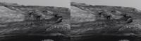
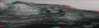
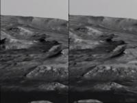
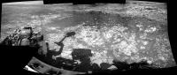
some stereo (cross-eye/anaglyph/parallel) of a couple frames ripped from Sean's absolutely remarkable rendered sequence. The path in the map that Fredk linked a few posts above would run up along the right bank of the channel as seen perhaps most distinctly in the parallel view at right, that sean pointed out a few posts above, though i was too lazy to attempt an oversketch of that route atop the frame.
|
|||
|
|
|
|||
|
Dec 21 2017, 04:33 PM
Post
#245
|
||
 Member Group: Members Posts: 888 Joined: 15-June 09 From: Lisbon, Portugal Member No.: 4824 |
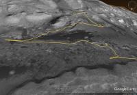
QUOTE (Sean @ Dec 20 2017, 10:42 AM)  I was wrong. Here is the ascent area according to the post by Fredk... Here is a vertically exagerated view of the notional route Fred mentions. You can grab a KML file with it from here. Fernando
|
|
|
|
|
|
|
Dec 22 2017, 09:07 PM
Post
#246
|
|
|
Member Group: Members Posts: 923 Joined: 10-November 15 Member No.: 7837 |
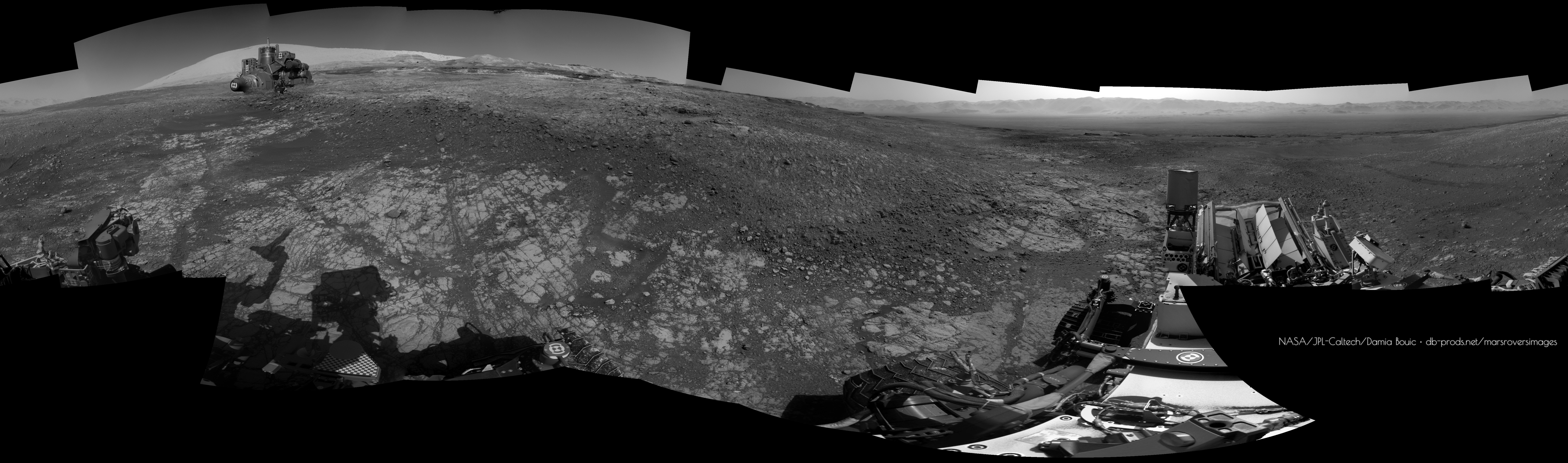
Here is a quick pass on a portion of the complete 360...
 Detail...  -------------------- |
|
|
|
|
Dec 22 2017, 09:33 PM
Post
#247
|
|
|
Senior Member Group: Members Posts: 2920 Joined: 14-February 06 From: Very close to the Pyrénées Mountains (France) Member No.: 682 |
QUOTE (nogal @ Dec 21 2017, 05:33 PM) Here is a vertically exagerated view of the notional route Fred mentions. You can grab a KML file with it from here. Fernando This is really helpful, thanks Fernardo -------------------- |
|
|
|
|
Dec 23 2017, 01:42 AM
Post
#248
|
||
|
Senior Member Group: Members Posts: 2428 Joined: 30-January 13 From: Penang, Malaysia. Member No.: 6853 |
Lovely work Sean....
~5.4 meter drive SE (Midnight Planets) partial L-NavCam, also in the set was a couple of top tier frames featuring the extended drill, but MS ICE would not stitch them on to the others 
|
|
|
|
|
|
|
Dec 23 2017, 11:29 AM
Post
#249
|
|
 Senior Member Group: Members Posts: 1619 Joined: 12-February 06 From: Bergerac - FR Member No.: 678 |
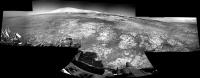
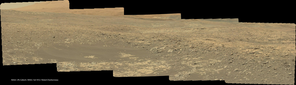
Sol 1912 Navcam panoramic.
 Paul, seriously, trash your Microsoft Ice thing. Maybe it's efficient with common pictures, but Navcam pictures are not common. Use Hugin, or PTGui or something. It will be better 
-------------------- |
|
|
|
|
Dec 23 2017, 12:21 PM
Post
#250
|
|
|
Member Group: Members Posts: 923 Joined: 10-November 15 Member No.: 7837 |
Another beautiful pano Damia. Do you straighten the horizon yourself? It always seems so 'locked in'. Looking forward to your debayered 1903 360...

-------------------- |
|
|
|
|
Dec 23 2017, 01:25 PM
Post
#251
|
|
|
Senior Member Group: Members Posts: 2346 Joined: 7-December 12 Member No.: 6780 |
Hugin finds correspondences itself. But with NavCam this usually doesn't work well. But you can add and remove these correspondences. By choosing such corresponding points near the horizon, you get a "locked" horizon.
|
|
|
|
|
Dec 23 2017, 01:51 PM
Post
#252
|
|
|
Member Group: Members Posts: 923 Joined: 10-November 15 Member No.: 7837 |
Thanks Gerald... I used Hugin a long time ago so I might give it another look.
-------------------- |
|
|
|
|
Dec 23 2017, 02:12 PM
Post
#253
|
|
|
Senior Member Group: Members Posts: 1619 Joined: 12-February 06 From: Bergerac - FR Member No.: 678 |
I'm doing it all manually. And all of my panoramas are made with manual settings, never automated process, with Navcam imagery.
And thanks you Sean I have a special project for this color panorama.
-------------------- |
|
|
|
|
Dec 24 2017, 11:15 PM
Post
#254
|
|
|
Senior Member Group: Members Posts: 1074 Joined: 21-September 07 From: Québec, Canada Member No.: 3908 |
Sol 1912 Lmastcam:
 I don't understand why some mastcam images are debayered, and some are not. |
|
|
|
|
Dec 28 2017, 12:01 PM
Post
#255
|
|
|
Newbie Group: Members Posts: 2 Joined: 4-March 14 Member No.: 7145 |
Does anyone know why MARDI was taking so many images during Sol 1910?
|
|
|
|
|

|
Lo-Fi Version | Time is now: 25th April 2024 - 11:04 AM |
|
RULES AND GUIDELINES Please read the Forum Rules and Guidelines before posting. IMAGE COPYRIGHT |
OPINIONS AND MODERATION Opinions expressed on UnmannedSpaceflight.com are those of the individual posters and do not necessarily reflect the opinions of UnmannedSpaceflight.com or The Planetary Society. The all-volunteer UnmannedSpaceflight.com moderation team is wholly independent of The Planetary Society. The Planetary Society has no influence over decisions made by the UnmannedSpaceflight.com moderators. |
SUPPORT THE FORUM Unmannedspaceflight.com is funded by the Planetary Society. Please consider supporting our work and many other projects by donating to the Society or becoming a member. |
|