Mars 3 (Various Topics Merged) |

Mars 3 (Various Topics Merged) |
 Dec 29 2004, 10:36 PM Dec 29 2004, 10:36 PM
Post
#1
|
|
 Interplanetary Dumpster Diver  Group: Admin Posts: 4404 Joined: 17-February 04 From: Powell, TN Member No.: 33 |
On my website sometime back, I added a page on the image fragment sent back by the Mars-3 Lander. I released serveral versions, including the best quality processing using othodox techniques I would use on other images plus colorization here:
http://pages.preferred.com/%7Etedstryk/fragmentc.jpg However, I released another image, which I called a "What if" image. This image can be seen here http://pages.preferred.com/%7Etedstryk/m3s5b.jpg It was produced via extreme processing of the original data to make a Mars-like scene, but I made it clear on my website it was only a speculative image. I strongly doubt if the raw data even shows Mars at all - it could be all noise. But since this mode of processing looked strangely Viking-like, I figured I would put it on the web. I was warned by several, who said that while fun, some kooks might take it seriously. My response was that I really don't care what kooks think. Then I noticed this web page: http://en.wikipedia.org/wiki/Mars_2 They used the overprocessed image. I feel like it is being presented as a true photograph. This is of concern. -------------------- |
 |
 
|
 |
|
Feb 14 2009, 02:51 AM
Post
#2
|
|
|
Solar System Cartographer Group: Members Posts: 10153 Joined: 5-April 05 From: Canada Member No.: 227 |
http://www.laspace.ru/rus/mars23.php
Lavochkin website on Mars 2 and mars 3. Hmmm. This is the source of the Wikipedia location for Mars 2 - 4° north, 47° west, near Nanedi Vallis in Xanthe Terra. (Thanks Maxim for the information). But this is completely at odds with information published at the time (links I'll have to dig out, but I think Marov & coauthor, Icarus, 1973) (atmospheric entry at 45 south, 313 west, with crash near 45 south 302 west). I'm not sure where this leaves the problem, but I don't think it is likely that these coordinates can be correct. Phil -------------------- ... because the Solar System ain't gonna map itself.
Also to be found posting similar content on https://mastodon.social/@PhilStooke Maps for download (free PD: https://upload.wikimedia.org/wikipedia/comm...Cartography.pdf NOTE: everything created by me which I post on UMSF is considered to be in the public domain (NOT CC, public domain) |
|
|
|
|
Feb 14 2009, 05:26 AM
Post
#3
|
||
 Member Group: Members Posts: 236 Joined: 5-June 08 From: Udon Thani Member No.: 4185 |
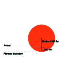
QUOTE (Phil Stooke @ Feb 14 2009, 09:51 AM)  I'm not sure where this leaves the problem, but I don't think it is likely that these coordinates can be correct. I fully agree with you that they are very (unlikely) far from the planned landing at Hellas. Perminov ('The difficult road to mars' NP-1999-06-251-HQ) does not mention any crash-location for Mars-2, and in my opinion his booklet is a quite accurate source for Soviet planetary flights in that period. If he does not mention a crash-location it sounds like nobody at the time was quite sure as to where it ended. If there were indeed no communications with the Mars 2/3 landers after release of the orbiter until after landing then how can we be sure its retro rocket actually fired? The lander might have missed Mars completely and ended up in solar orbit... I'm still trying to work it out, but the landers used a solid propellant retro rocket, causing a 120 m/sec velocity change. They were released at 46000 km from Mars in an orientation almost perpendicular to the fightpath (drawing at page 53 of the Perminov booklet). The lander was spin-stabilised after release and automatically fired its rocket 900 seconds after release, everything completely pre-programmed. As it was released perpendicular to the flightpath, the pulse of the lander engine did not so much 'brake' its speed as well change the vector and reduce the fly-by distance from 1500 km to zero. In this scenario there is actually not so much you can do to 'steepen' the descent, almost any error in orientation will cause the lander to 'miss' Mars altogether and disappear into solar orbit. So, it sounds like the whole scenario depended on the trajectory of the mothership at the moment of release, and this is probably what went wrong with Mars 2. According to plan (Perminov, page 53 again) the mothership would be in a trajectory with a fly-by distance of 2350 km +- 1000 km prior to its third and final course correction. This course correction was automatically computed by the onboard computer, and should have resulted in a fly-by distance of 1500 km +- 200 km, where after the lander was released. On Mars 2 the mothership was actually in a fly-by trajectory with a fly by distance of aprox 1500 km prior to the third correction, but instead of skipping the third correction, the onboard computer ordered a third correction which actually 'overcompensated' and decreased the fly-by distance too far. (Perminov, page 57). Mars 2 there after ended up in an orbit with a perigee of 1350 km instead of 1500 km. Thus it sounds like the whole error was in the final trajectory on release of the lander, which was too steep with a too close fly-by distance. Supposing the lander rocket fired correctly (which we can't be sure of!) this would indeed result in a descent which was too steep. However, the trajectory can't have been too far off, otherwise the mothership would have burned up in the atmosphere, which it didn't. It's all 'back of the envelope' calculations, but let's say Mars 2 was 300 km 'off track' on release of the lander, then the final entry trajectory of the lander must have been 300 km off track as well (impuls of solid rocket was fixed, lander sequence pre-programmed). Given a Mars radius of 3396 km, this would result in an atmospheric entry angle of 90 - ASIN((3396 - 300) / 3396) = 25 degrees, which is obviously too steep. Presuming the original entry angle was close to zero, error in landing location would in this case also be 25 degrees, or 1481 km. (see attached drawing).
The very, very, worst case scenario (given the mothership did not burn up in the atmosphere, so must have passed let's say minimum 200 km) would put the lander off track by 1300 km perpendicular to its trajectory, which will give an atmospheric entry angle of 52 degrees and an error in landing location of 3081 km. That's absolutely the very worst case scenario, I can't create a bigger error given the fact that the mothership obviously survived... So 'most likely' error would be in the range of 1481 km maximum and absolutely worst case error would be 3081 km. It looks to me like the lander was targeted for the Hellas bassin (they seem to have targeted for locations imaged by Mariner 4/6/7 so targeted area must be within one of these pictures), so draw an E-W elips with a maximum radius of 1481 km centered on the Hellas location and start searching... Note this is all 'back of the envelope' calculating, obviously a lot of factors aren't taken into account but it give's the basic idea of what error we are looking for. Regarding Mars 3 and 6, the Perminov booklet states a maximum allowed error in atmospheric entry error of 5 degrees, if you ignore all other factors, this gives a landing elips with a maximum radius of almost 300 km (any bigger error and they wouldn't have survived entry). It remains a very big area to search... Regards, Geert. |
|
|
|
|
|
 tedstryk Mars 3 (Various Topics Merged) Dec 29 2004, 10:36 PM
 lyford Since it's Wikipedia, can't you just delet... Dec 29 2004, 11:09 PM tedstryk Thanks. I will be updating the Phobos-2 section s... Dec 30 2004, 01:12 AM PhilHorzempa [size=2]
With regard to the Soviet Mars lan... Apr 18 2006, 10:02 PM BruceMoomaw The Soviets actually do firmly know why Mars 2 fai... Apr 18 2006, 10:18 PM
lyford Since it's Wikipedia, can't you just delet... Dec 29 2004, 11:09 PM tedstryk Thanks. I will be updating the Phobos-2 section s... Dec 30 2004, 01:12 AM PhilHorzempa [size=2]
With regard to the Soviet Mars lan... Apr 18 2006, 10:02 PM BruceMoomaw The Soviets actually do firmly know why Mars 2 fai... Apr 18 2006, 10:18 PM tedstryk QUOTE (BruceMoomaw @ Apr 18 2006, 10:18 P... Apr 18 2006, 10:41 PM
 The Messenger QUOTE (BruceMoomaw @ Apr 18 2006, 04:18 P... Apr 19 2006, 03:59 PM mcaplinger QUOTE (The Messenger @ Apr 19 2006, 08:59... Apr 19 2006, 04:20 PM The Messenger QUOTE (mcaplinger @ Apr 19 2006, 10:20 AM... Apr 19 2006, 05:56 PM mcaplinger QUOTE (The Messenger @ Apr 19 2006, 10:56... Apr 19 2006, 06:20 PM The Messenger QUOTE (mcaplinger @ Apr 19 2006, 12:20 PM... Apr 21 2006, 03:53 PM mcaplinger QUOTE (The Messenger @ Apr 21 2006, 08:53... Apr 21 2006, 04:28 PM BruceMoomaw Oh, yes, Perminov goes into great detail about the... Apr 19 2006, 02:49 PM PhilHorzempa [size=2]
This discussion is very relevant to ... Apr 19 2006, 04:53 PM tasp Sorry I can't cite a reference for this, but i... Apr 19 2006, 05:51 PM ljk4-1 Two very relevant documents to this thread online:... Apr 19 2006, 06:01 PM tasp QUOTE (tedstryk @ Dec 29 2004, 05:36 PM) ... Apr 19 2006, 06:06 PM Phil Stooke tasp said "can any amount of processing put c... Apr 19 2006, 08:12 PM djellison My take on it is - it might be a real picture, and... Apr 19 2006, 08:41 PM tedstryk QUOTE (djellison @ Apr 19 2006, 08:41 PM)... Apr 19 2006, 10:16 PM BruceMoomaw QUOTE (tedstryk @ Apr 19 2006, 10:16 PM) ... Apr 20 2006, 01:52 AM tedstryk QUOTE (BruceMoomaw @ Apr 20 2006, 01:52 A... Apr 20 2006, 02:35 AM ljk4-1 As I recall, the famous Mars 3 image was first sho... Apr 20 2006, 12:22 AM BruceMoomaw Yeah, atmospheric conditions would have a lot to d... Apr 20 2006, 05:05 AM ljk4-1 This company (which I have no involvement with) is... May 1 2006, 04:01 PM Bob Shaw QUOTE (ljk4-1 @ May 1 2006, 05:01 PM... May 1 2006, 05:08 PM tedstryk I have one, and am quite fond of it May 1 2006, 08:28 PM vikingmars QUOTE (tedstryk @ Dec 30 2004, 12:36 AM) ... May 2 2006, 08:37 AM tedstryk QUOTE (vikingmars @ May 2 2006, 08:37 AM)... May 2 2006, 09:32 AM djellison Might it be a vertically oriented image, but with ... May 2 2006, 09:59 AM tedstryk QUOTE (djellison @ May 2 2006, 09:59 AM) ... May 2 2006, 10:23 AM 4th rock from the sun QUOTE (djellison @ May 2 2006, 10:59 AM) ... May 2 2006, 01:44 PM vikingmars QUOTE (4th rock from the sun @ May 2 2006, 03... May 3 2006, 08:57 AM 4th rock from the sun Just some data, to make things clearer:
The Mars ... May 3 2006, 03:14 PM PhilHorzempa I thought that we could try to get the record stra... May 10 2006, 04:42 AM Phil Stooke I have never heard 'Mars 8' used for that ... May 10 2006, 04:59 PM ljk4-1 QUOTE (Phil Stooke @ May 10 2006, 12:59 P... May 10 2006, 05:23 PM tedstryk Mars '96 would have been Mars 8 if it hadn... May 10 2006, 05:29 PM Zvezdichko 36 years ago, on this very same day, 2 December 19... Dec 2 2007, 11:58 AM Adam I might be wrong, but wasn't it pretty much de... Dec 2 2007, 12:12 PM Zvezdichko Yes. There have been speculations based on this im... Dec 2 2007, 12:16 PM nprev A date & an achievement worth noting to be sur... Dec 2 2007, 01:17 PM Zvezdichko Yes, only 14 years after Sputnik mankind achieved ... Dec 2 2007, 10:33 PM dilo Perhaps a little bit OT, but not completely...
Tod... Dec 2 2007, 11:14 PM peter59 QUOTE (dilo @ Dec 3 2007, 12:14 AM) Is in... Dec 3 2007, 06:13 PM dilo QUOTE (peter59 @ Dec 3 2007, 07:13 PM) EX... Dec 4 2007, 04:28 PM nprev You're absolutely right, Dilo...we need to kee... Dec 3 2007, 02:48 AM Shaka Good, that makes three dreamers at UMSF.
How many ... Dec 3 2007, 05:20 AM marsbug QUOTE (Shaka @ Dec 3 2007, 05:20 AM)
Go... Dec 4 2007, 04:48 PM PDP8E another more recent thread (36 years on mars) has ... Dec 3 2007, 02:56 PM tedstryk QUOTE (PDP8E @ Dec 3 2007, 02:56 PM) anot... Dec 3 2007, 05:22 PM PhilCo126 Wait one minute, a topic on spacecraft lost around... Dec 4 2007, 06:55 PM PDP8E MY SPECULATIVE ANALYSIS OF THE SOVIET MARS 3 LANDE... Dec 12 2007, 06:57 PM vikingmars QUOTE (PDP8E @ Dec 12 2007, 07:57 PM) Som... Dec 16 2007, 09:34 PM Phil Stooke "Its easy
look in and near northern Ptolemy C... Dec 12 2007, 07:50 PM djellison So a 400km x 400km search box. 160,000 sqkm
That... Dec 12 2007, 08:02 PM PDP8E A brief scan of the web turned up these images of ... Dec 14 2007, 03:51 PM Paolo QUOTE (PDP8E @ Dec 14 2007, 04:51 PM) A b... Dec 15 2007, 08:18 AM PhilCo126 Thanks for sharing those photos and only the black... Dec 15 2007, 05:54 PM PDP8E We have had 8 more inches of snow today on top of ... Dec 16 2007, 08:36 PM Geert Various sources all seem to confirm that the camer... Jun 6 2008, 07:56 AM tedstryk Two or three minutes into the transmission, the fi... Jun 6 2008, 01:50 PM aconnell Dear Tedstryk. I'd be really grateful if you c... Jun 6 2008, 05:11 PM tedstryk It was an image I clearly labeled a "what if... Jun 6 2008, 05:46 PM nprev I don't know, Ted. They're undeniably fasc... Jun 6 2008, 07:06 PM tedstryk nprev, as I said in my description at the beginnin... Jun 6 2008, 08:26 PM Geert On his excellent site on Soviet Space Cameras ( ht... Jun 7 2008, 08:42 AM aconnell Many thanks Ted. I can remember as a teenager in t... Jun 7 2008, 02:09 PM tedstryk It is a shame they didn't start the transmissi... Jun 7 2008, 02:26 PM Zvezdichko Conspiracy theorists are and will always be a lost... Jun 7 2008, 02:39 PM tedstryk QUOTE (Zvezdichko @ Jun 7 2008, 02:39 PM)... Jun 7 2008, 03:02 PM Zvezdichko Yeah, MetNet is an elegant decision. However, I... Jun 7 2008, 03:23 PM tedstryk QUOTE (Zvezdichko @ Jun 7 2008, 03:23 PM)... Jun 7 2008, 03:28 PM tedstryk Oh, OK, in the sense of possible launch failure. ... Jun 7 2008, 03:46 PM Zvezdichko I personally see Volna as an unreliable vehicle. Jun 7 2008, 03:35 PM Zvezdichko Yeah, that's what I meant. Volna failed to lau... Jun 7 2008, 03:49 PM tedstryk My guess is that the little Chinese orbiter took i... Jun 7 2008, 03:54 PM Zvezdichko I understand, but I also don't see how the des... Jun 7 2008, 04:02 PM tedstryk QUOTE (Zvezdichko @ Jun 7 2008, 04:02 PM)... Jun 7 2008, 04:05 PM Zvezdichko You are probably right. The Chinese orbiter will b... Jun 7 2008, 04:17 PM tedstryk QUOTE (Zvezdichko @ Jun 7 2008, 05:17 PM)... Jun 7 2008, 06:16 PM Zvezdichko Yeah, that's why the failure of Mars 96 was re... Jun 7 2008, 06:41 PM tedstryk I hope it makes it on there!
By the way, here... Jun 8 2008, 04:34 AM Zvezdichko Ted, I'm reading the upper link with a great i... Jun 8 2008, 07:54 AM tedstryk I don't think the Mars-6 flyby module took ima... Jun 8 2008, 12:52 PM Geert QUOTE (Zvezdichko @ Jun 8 2008, 02:54 PM)... Jun 9 2008, 05:12 AM tedstryk QUOTE (Geert @ Jun 9 2008, 06:12 AM) The ... Jun 9 2008, 12:53 PM Phil Stooke A different story on Mars 2 and Mars 3.
Where d... Feb 5 2009, 12:14 AM tedstryk According to Sasha Basilevsky, Hellas was chosen f... Feb 5 2009, 12:39 AM Phil Stooke Yikes - Google Mars has Mars 2 at the stupid Wikip... Feb 5 2009, 04:36 AM Geert QUOTE (Phil Stooke @ Feb 5 2009, 11:36 AM... Feb 6 2009, 09:38 AM Phil Stooke Way off course by a few hundred km maybe, not half... Feb 6 2009, 11:50 AM Geert QUOTE (Phil Stooke @ Feb 6 2009, 06:50 PM... Feb 7 2009, 04:51 AM tedstryk QUOTE (Geert @ Feb 7 2009, 05:51 AM) It i... Feb 7 2009, 01:47 PM DDAVIS 'The fact that the landingsites were chosen fr... Feb 7 2009, 10:05 PM Phil Stooke Hi Don! You are thinking of Mars 6. The Mari... Feb 7 2009, 11:16 PM Geert Forgot to mention that according to the above reas... Feb 14 2009, 05:41 AM nprev Thank you for this very comprehensive and interest... Feb 14 2009, 07:10 AM
The Messenger QUOTE (BruceMoomaw @ Apr 18 2006, 04:18 P... Apr 19 2006, 03:59 PM mcaplinger QUOTE (The Messenger @ Apr 19 2006, 08:59... Apr 19 2006, 04:20 PM The Messenger QUOTE (mcaplinger @ Apr 19 2006, 10:20 AM... Apr 19 2006, 05:56 PM mcaplinger QUOTE (The Messenger @ Apr 19 2006, 10:56... Apr 19 2006, 06:20 PM The Messenger QUOTE (mcaplinger @ Apr 19 2006, 12:20 PM... Apr 21 2006, 03:53 PM mcaplinger QUOTE (The Messenger @ Apr 21 2006, 08:53... Apr 21 2006, 04:28 PM BruceMoomaw Oh, yes, Perminov goes into great detail about the... Apr 19 2006, 02:49 PM PhilHorzempa [size=2]
This discussion is very relevant to ... Apr 19 2006, 04:53 PM tasp Sorry I can't cite a reference for this, but i... Apr 19 2006, 05:51 PM ljk4-1 Two very relevant documents to this thread online:... Apr 19 2006, 06:01 PM tasp QUOTE (tedstryk @ Dec 29 2004, 05:36 PM) ... Apr 19 2006, 06:06 PM Phil Stooke tasp said "can any amount of processing put c... Apr 19 2006, 08:12 PM djellison My take on it is - it might be a real picture, and... Apr 19 2006, 08:41 PM tedstryk QUOTE (djellison @ Apr 19 2006, 08:41 PM)... Apr 19 2006, 10:16 PM BruceMoomaw QUOTE (tedstryk @ Apr 19 2006, 10:16 PM) ... Apr 20 2006, 01:52 AM tedstryk QUOTE (BruceMoomaw @ Apr 20 2006, 01:52 A... Apr 20 2006, 02:35 AM ljk4-1 As I recall, the famous Mars 3 image was first sho... Apr 20 2006, 12:22 AM BruceMoomaw Yeah, atmospheric conditions would have a lot to d... Apr 20 2006, 05:05 AM ljk4-1 This company (which I have no involvement with) is... May 1 2006, 04:01 PM Bob Shaw QUOTE (ljk4-1 @ May 1 2006, 05:01 PM... May 1 2006, 05:08 PM tedstryk I have one, and am quite fond of it May 1 2006, 08:28 PM vikingmars QUOTE (tedstryk @ Dec 30 2004, 12:36 AM) ... May 2 2006, 08:37 AM tedstryk QUOTE (vikingmars @ May 2 2006, 08:37 AM)... May 2 2006, 09:32 AM djellison Might it be a vertically oriented image, but with ... May 2 2006, 09:59 AM tedstryk QUOTE (djellison @ May 2 2006, 09:59 AM) ... May 2 2006, 10:23 AM 4th rock from the sun QUOTE (djellison @ May 2 2006, 10:59 AM) ... May 2 2006, 01:44 PM vikingmars QUOTE (4th rock from the sun @ May 2 2006, 03... May 3 2006, 08:57 AM 4th rock from the sun Just some data, to make things clearer:
The Mars ... May 3 2006, 03:14 PM PhilHorzempa I thought that we could try to get the record stra... May 10 2006, 04:42 AM Phil Stooke I have never heard 'Mars 8' used for that ... May 10 2006, 04:59 PM ljk4-1 QUOTE (Phil Stooke @ May 10 2006, 12:59 P... May 10 2006, 05:23 PM tedstryk Mars '96 would have been Mars 8 if it hadn... May 10 2006, 05:29 PM Zvezdichko 36 years ago, on this very same day, 2 December 19... Dec 2 2007, 11:58 AM Adam I might be wrong, but wasn't it pretty much de... Dec 2 2007, 12:12 PM Zvezdichko Yes. There have been speculations based on this im... Dec 2 2007, 12:16 PM nprev A date & an achievement worth noting to be sur... Dec 2 2007, 01:17 PM Zvezdichko Yes, only 14 years after Sputnik mankind achieved ... Dec 2 2007, 10:33 PM dilo Perhaps a little bit OT, but not completely...
Tod... Dec 2 2007, 11:14 PM peter59 QUOTE (dilo @ Dec 3 2007, 12:14 AM) Is in... Dec 3 2007, 06:13 PM dilo QUOTE (peter59 @ Dec 3 2007, 07:13 PM) EX... Dec 4 2007, 04:28 PM nprev You're absolutely right, Dilo...we need to kee... Dec 3 2007, 02:48 AM Shaka Good, that makes three dreamers at UMSF.
How many ... Dec 3 2007, 05:20 AM marsbug QUOTE (Shaka @ Dec 3 2007, 05:20 AM)
Go... Dec 4 2007, 04:48 PM PDP8E another more recent thread (36 years on mars) has ... Dec 3 2007, 02:56 PM tedstryk QUOTE (PDP8E @ Dec 3 2007, 02:56 PM) anot... Dec 3 2007, 05:22 PM PhilCo126 Wait one minute, a topic on spacecraft lost around... Dec 4 2007, 06:55 PM PDP8E MY SPECULATIVE ANALYSIS OF THE SOVIET MARS 3 LANDE... Dec 12 2007, 06:57 PM vikingmars QUOTE (PDP8E @ Dec 12 2007, 07:57 PM) Som... Dec 16 2007, 09:34 PM Phil Stooke "Its easy
look in and near northern Ptolemy C... Dec 12 2007, 07:50 PM djellison So a 400km x 400km search box. 160,000 sqkm
That... Dec 12 2007, 08:02 PM PDP8E A brief scan of the web turned up these images of ... Dec 14 2007, 03:51 PM Paolo QUOTE (PDP8E @ Dec 14 2007, 04:51 PM) A b... Dec 15 2007, 08:18 AM PhilCo126 Thanks for sharing those photos and only the black... Dec 15 2007, 05:54 PM PDP8E We have had 8 more inches of snow today on top of ... Dec 16 2007, 08:36 PM Geert Various sources all seem to confirm that the camer... Jun 6 2008, 07:56 AM tedstryk Two or three minutes into the transmission, the fi... Jun 6 2008, 01:50 PM aconnell Dear Tedstryk. I'd be really grateful if you c... Jun 6 2008, 05:11 PM tedstryk It was an image I clearly labeled a "what if... Jun 6 2008, 05:46 PM nprev I don't know, Ted. They're undeniably fasc... Jun 6 2008, 07:06 PM tedstryk nprev, as I said in my description at the beginnin... Jun 6 2008, 08:26 PM Geert On his excellent site on Soviet Space Cameras ( ht... Jun 7 2008, 08:42 AM aconnell Many thanks Ted. I can remember as a teenager in t... Jun 7 2008, 02:09 PM tedstryk It is a shame they didn't start the transmissi... Jun 7 2008, 02:26 PM Zvezdichko Conspiracy theorists are and will always be a lost... Jun 7 2008, 02:39 PM tedstryk QUOTE (Zvezdichko @ Jun 7 2008, 02:39 PM)... Jun 7 2008, 03:02 PM Zvezdichko Yeah, MetNet is an elegant decision. However, I... Jun 7 2008, 03:23 PM tedstryk QUOTE (Zvezdichko @ Jun 7 2008, 03:23 PM)... Jun 7 2008, 03:28 PM tedstryk Oh, OK, in the sense of possible launch failure. ... Jun 7 2008, 03:46 PM Zvezdichko I personally see Volna as an unreliable vehicle. Jun 7 2008, 03:35 PM Zvezdichko Yeah, that's what I meant. Volna failed to lau... Jun 7 2008, 03:49 PM tedstryk My guess is that the little Chinese orbiter took i... Jun 7 2008, 03:54 PM Zvezdichko I understand, but I also don't see how the des... Jun 7 2008, 04:02 PM tedstryk QUOTE (Zvezdichko @ Jun 7 2008, 04:02 PM)... Jun 7 2008, 04:05 PM Zvezdichko You are probably right. The Chinese orbiter will b... Jun 7 2008, 04:17 PM tedstryk QUOTE (Zvezdichko @ Jun 7 2008, 05:17 PM)... Jun 7 2008, 06:16 PM Zvezdichko Yeah, that's why the failure of Mars 96 was re... Jun 7 2008, 06:41 PM tedstryk I hope it makes it on there!
By the way, here... Jun 8 2008, 04:34 AM Zvezdichko Ted, I'm reading the upper link with a great i... Jun 8 2008, 07:54 AM tedstryk I don't think the Mars-6 flyby module took ima... Jun 8 2008, 12:52 PM Geert QUOTE (Zvezdichko @ Jun 8 2008, 02:54 PM)... Jun 9 2008, 05:12 AM tedstryk QUOTE (Geert @ Jun 9 2008, 06:12 AM) The ... Jun 9 2008, 12:53 PM Phil Stooke A different story on Mars 2 and Mars 3.
Where d... Feb 5 2009, 12:14 AM tedstryk According to Sasha Basilevsky, Hellas was chosen f... Feb 5 2009, 12:39 AM Phil Stooke Yikes - Google Mars has Mars 2 at the stupid Wikip... Feb 5 2009, 04:36 AM Geert QUOTE (Phil Stooke @ Feb 5 2009, 11:36 AM... Feb 6 2009, 09:38 AM Phil Stooke Way off course by a few hundred km maybe, not half... Feb 6 2009, 11:50 AM Geert QUOTE (Phil Stooke @ Feb 6 2009, 06:50 PM... Feb 7 2009, 04:51 AM tedstryk QUOTE (Geert @ Feb 7 2009, 05:51 AM) It i... Feb 7 2009, 01:47 PM DDAVIS 'The fact that the landingsites were chosen fr... Feb 7 2009, 10:05 PM Phil Stooke Hi Don! You are thinking of Mars 6. The Mari... Feb 7 2009, 11:16 PM Geert Forgot to mention that according to the above reas... Feb 14 2009, 05:41 AM nprev Thank you for this very comprehensive and interest... Feb 14 2009, 07:10 AM |

|
Lo-Fi Version | Time is now: 28th April 2024 - 09:58 AM |
|
RULES AND GUIDELINES Please read the Forum Rules and Guidelines before posting. IMAGE COPYRIGHT |
OPINIONS AND MODERATION Opinions expressed on UnmannedSpaceflight.com are those of the individual posters and do not necessarily reflect the opinions of UnmannedSpaceflight.com or The Planetary Society. The all-volunteer UnmannedSpaceflight.com moderation team is wholly independent of The Planetary Society. The Planetary Society has no influence over decisions made by the UnmannedSpaceflight.com moderators. |
SUPPORT THE FORUM Unmannedspaceflight.com is funded by the Planetary Society. Please consider supporting our work and many other projects by donating to the Society or becoming a member. |
|