Beyond Lewis and Clark Gap, Sol 4482- (September 2, 2016-) |

  |
Beyond Lewis and Clark Gap, Sol 4482- (September 2, 2016-) |
 May 29 2017, 03:24 AM May 29 2017, 03:24 AM
Post
#301
|
||
|
Member  Group: Members Posts: 507 Joined: 10-September 08 Member No.: 4338 |
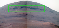
Beautiful images jccwrt and James Sorenson Apologies for the poor stitching in my version. False color and enhancement to emphasize particular features. Any ideas on what caused the massive soil disturbances in the otherwise smooth hillside? |
|
 |
 
|
|
| Guest_Steve5304_* |
May 30 2017, 04:02 PM
Post
#302
|
|
|
Guests |
QUOTE (marsophile @ May 29 2017, 04:24 AM) 
Beautiful images jccwrt and James Sorenson Apologies for the poor stitching in my version. False color and enhancement to emphasize particular features. Any ideas on what caused the massive soil disturbances in the otherwise smooth hillside? I'm not seeing any disturbance care to point it out in the photo? I see rover tracks and gravity tumbles. |
|
|
|
|
|
|
May 30 2017, 04:17 PM
Post
#303
|
|||
|
Member Group: Members Posts: 507 Joined: 10-September 08 Member No.: 4338 |
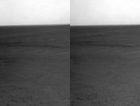
I guess it must be the gravity tumbles, by the sound of it. Is that a commonplace phenomenon?
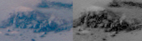
This is one of the disturbed areas.
This is parallel-eye stereo of part of the area. |
||
|
|
|
||
|
May 31 2017, 12:36 AM
Post
#304
|
|
|
Member Group: Members Posts: 866 Joined: 15-March 05 From: Santa Cruz, CA Member No.: 196 |
Perhaps you are referring to the horizontal band of bedrock dominating the upper left third section in this sol4743 image? From this tricky perspective, especially if like me you grew up in mudslide country where such formations are common, the eyes might suggest the resemblance of this to the tongue of a soil slump feature, but my take is it's a major bedrock layer preserved by, well, the lack of gravity tumbles, the erosion of the surrounding soil leaving it in high relief, and a small sampling of rocks from the bedrock layer doing gravity tumbles to litter the base of the section.. but the uncanny resemblance to some sort of mudslide tongue (or whatever you call that) from this viewpoint did strike me as well, almost like a wave coming down!
|
|
|
|
|
Jun 1 2017, 04:31 AM
Post
#305
|
|||
|
Member Group: Members Posts: 507 Joined: 10-September 08 Member No.: 4338 |
Long baseline stereo (visually matched from images on different Sols).
Parallel-eye:
Cross-eye:
|
||
|
|
|
||
|
Jun 4 2017, 04:27 AM
Post
#306
|
||
|
Member Group: Members Posts: 808 Joined: 10-October 06 From: Maynard Mass USA Member No.: 1241 |
My on-again off-again stitching has always been on a slow learning curve, especially with all the different tools I have downloaded since the beginning of this mission
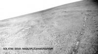
Here is the first stitch that I felt good enough about to share (after 4744 sols!) Two whole images in one.... (whew)
-------------------- CLA CLL
|
|
|
|
|
|
|
Jun 7 2017, 04:02 AM
Post
#307
|
|
|
Member Group: Members Posts: 507 Joined: 10-September 08 Member No.: 4338 |
http://www.planetary.org/explore/space-top...nce-valley.html
Monthly MER Report from The Planetary Society. It seems this winter may be challenging from an energy point of view. |
|
|
|
|
Jun 7 2017, 11:53 PM
Post
#308
|
|||
|
Member Group: Members Posts: 866 Joined: 15-March 05 From: Santa Cruz, CA Member No.: 196 |
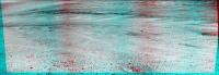
great article! thanks for linking it. I had always been curious about the linear feature running from the plains up to the valley edge, that shows up as a sort of thin rusty line in the HIRISE images linked in the story, Crumplers view, and especially this one, but couldn't imagine it being a relic of a water erosion channel, if thats ineed teh features in question, in which case the idea seems to not be out of the question, this early on at least, as suggested about those sol4747 images, of which the below crosseye and parallel view provides some terrain relief, whether it be a remnant channel from a spillover lake, or evidence of wind-scoured faulting, or something else entirely..
|
||
|
|
|
||
|
Jun 8 2017, 11:55 PM
Post
#309
|
|
 Member Group: Members Posts: 754 Joined: 9-February 07 Member No.: 1700 |
As usual, I'm future-tripping 😅 Are they postulating a return up Perseverance Valley after the downward trek, or do they envision continuing to the crater floor?
|
|
|
|
|
Jun 9 2017, 12:04 AM
Post
#310
|
|
|
Solar System Cartographer Group: Members Posts: 10150 Joined: 5-April 05 From: Canada Member No.: 227 |
To the crater floor, south, and up again further south.
Phil -------------------- ... because the Solar System ain't gonna map itself.
Also to be found posting similar content on https://mastodon.social/@PhilStooke NOTE: everything created by me which I post on UMSF is considered to be in the public domain (NOT CC, public domain) |
|
|
|
|
Jun 9 2017, 08:45 PM
Post
#311
|
|
 Member Group: Members Posts: 656 Joined: 20-April 05 From: League City, Texas Member No.: 285 |
QUOTE (Phil Stooke @ Jun 8 2017, 06:04 PM) To the crater floor.... I was just looking at the overview map of the path that Opportunity has covered -- over the plains and along the crater rim -- which led me to thinking that we really need to get down on the crater floor. That is potentially a whole new realm of geology, and if the plains were historically wet (at least in the subsurface), perhaps something even more interesting was going on within the crater. Incidentally, I'm surprised that nobody has posted some large stereo panoramas of the long-baseline surveys of the "channel". Just at the moment, looking over what I've seen so far, I'm having one of those "the emperor has no clothes" feelings. But the HiRISE imagery is very persuasive. |
|
|
|
|
Jun 11 2017, 02:06 AM
Post
#312
|
|
|
Member Group: Members Posts: 507 Joined: 10-September 08 Member No.: 4338 |
https://mars.nasa.gov/mer/mission/status.html#opportunity
Seems to be an issue with the left front steering actuator. Hope this doesn't affect the exploration plans. |
|
|
|
|
Jun 11 2017, 02:47 PM
Post
#313
|
|
 Senior Member Group: Members Posts: 4246 Joined: 17-January 05 Member No.: 152 |
The plan was to try to straighten the LF wheel on 4754 but I see no sign of movement in the hazcams...
|
|
|
|
| Guest_Steve5304_* |
Jun 12 2017, 03:24 PM
Post
#314
|
|
Guests |
QUOTE (fredk @ Jun 11 2017, 03:47 PM) The plan was to try to straighten the LF wheel on 4754 but I see no sign of movement in the hazcams... hope this is not the beginning of the end  These things way outlived their life I sort took advantage of that fact. |
|
|
|
|
Jun 13 2017, 12:26 AM
Post
#315
|
|||
|
Member Group: Members Posts: 866 Joined: 15-March 05 From: Santa Cruz, CA Member No.: 196 |
here's a rough widebase anaglyph of sol4749 x sol4754 stitches. interesting how its almost as if a lake shoreline feeds the channel narrowing towards the rim in these images, which hadn't seemed as apparent until now. also attaching the full sol4754 stitch as well with lightened leftmost image and scaled 50% to fit post limit.
|
||
|
|
|
||
|

|
Lo-Fi Version | Time is now: 24th April 2024 - 05:41 AM |
|
RULES AND GUIDELINES Please read the Forum Rules and Guidelines before posting. IMAGE COPYRIGHT |
OPINIONS AND MODERATION Opinions expressed on UnmannedSpaceflight.com are those of the individual posters and do not necessarily reflect the opinions of UnmannedSpaceflight.com or The Planetary Society. The all-volunteer UnmannedSpaceflight.com moderation team is wholly independent of The Planetary Society. The Planetary Society has no influence over decisions made by the UnmannedSpaceflight.com moderators. |
SUPPORT THE FORUM Unmannedspaceflight.com is funded by the Planetary Society. Please consider supporting our work and many other projects by donating to the Society or becoming a member. |
|