Printable Version of Topic
Click here to view this topic in its original format
Unmanned Spaceflight.com _ Saturn _ Titan from Voyager 1
Posted by: Spock1108 Nov 27 2016, 05:23 PM
Analyzing this Titan photos of Voyager 1 shows a hood ... it is to the north or the south pole?
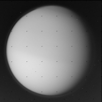
|
Posted by: john_s Nov 28 2016, 03:54 AM
That's the north polar hood. The Voyager 1 flyby was just after northern Spring equinox, so the hood from the previous northern winter had not yet dissipated.
John
Posted by: JohnVV Nov 30 2016, 04:28 AM
not 100% sure the exact same image
" c3491749.imq "
added a grid , the blue dot is 0 lat and 180 long , the yellow dot id the northpole
http://imgbox.com/0nTHEvB6
Posted by: Seryddwr Sep 3 2017, 10:54 PM
Am I imagining this, or did someone point out some time ago that if you process the living daylights out of Voyager 1 imagery, the northern lakes are just visible? I thought I read this on this forum somewhere, but am having trouble finding it with the search terms I am using, and Google doesn't seem to be my friend either.
Posted by: Explorer1 Sep 4 2017, 01:27 AM
I could swear I remembered a thread too. There is http://citeseerx.ist.psu.edu/viewdoc/download?doi=10.1.1.205.4987&rep=rep1&type=pdf, though I can't recall finding the thread itself.
Posted by: JohnVV Sep 4 2017, 02:21 AM
i do not think it was titan , but Uranus
you can get a few things out of the 8 bit images for that planet , but most things are just the 8 bit depth
Posted by: Phil Stooke Sep 4 2017, 05:38 AM
I do recall a study which showed very faint dark markings on Titan in Voyager 1 images. Not back in the early 80s, but quite a bit later, I think. And absolutely not the polar lakes, but the areas we now know to be dark sand dunes near the equator. But there was never a clear view of anything, only the very vaguest hint of dark areas. I don't recall any comparison with recent maps.
EDIT - oops, there was a comparison! Here is the paper:
http://www.jerichardsonjr.info/Papers/jerichardson_ICAR2004.pdf
Phil
Posted by: tedstryk Sep 4 2017, 11:30 PM
This is why I so much hoped to find the digital Pioneer 11 scans. It had a true red channel, so although the resolution was poor, extracting the surface just might be possible.
Posted by: Seryddwr Sep 5 2017, 12:20 AM

Really? So what happened? They were received on the ground, but cannot now be found in the archives?
Posted by: vikingmars Sep 5 2017, 06:51 AM
Thank you Seryddwr for your good question.
Sometimes, old data cannot now be found in the archives, mainly because it were stored on magnetic tapes, and some of it was lost (or wrongly classified) or even damaged in the storage areas or even erased by other data input. A good example is the famous case of the "Apollo 11 missing tapes" :
https://en.wikipedia.org/wiki/Apollo_11_missing_tapes
At this time, the NSSDC was not organized to cope with the managing of planetary data and this is why the PDS was created to handle and distribute it.
Here are some interesting papers summarizing the history of the PDS and its activities :
http://citeseerx.ist.psu.edu/viewdoc/download?doi=10.1.1.100.3545&rep=rep1&type=pdf
https://www.hou.usra.edu/meetings/planetdata2015/pdf/7028.pdf
http://www.lpi.usra.edu/pss/mar2015/PDS.pdf
Well, tedstryk is UMSF's "imaging wizard"... Who knows ? Just wait : patience is required...

Powered by Invision Power Board (http://www.invisionboard.com)
© Invision Power Services (http://www.invisionpower.com)