Printable Version of Topic
Click here to view this topic in its original format
Unmanned Spaceflight.com _ MSL _ MSL Post-conjunction: Drilling at Cumberland, Revisiting Point Lake and Shaler
Posted by: Phil Stooke May 10 2013, 03:34 AM
Now we have a new drill target:
http://www.jpl.nasa.gov/news/news.php?release=2013-159
Phil
Posted by: Gerald May 10 2013, 11:48 AM
http://mars.jpl.nasa.gov/msl-raw-images/msss/00192/mcam/0192MR1017043000E1_DXXX.jpg is the according raw Sol 192 Mastcam Right image showing 'Cumberland', http://mars.jpl.nasa.gov/msl-raw-images/msss/00192/mcam/0192ML1017043000E1_DXXX.jpg some more context, and http://mars.jpl.nasa.gov/msl-raw-images/proj/msl/redops/ods/surface/sol/00269/opgs/edr/ncam/NRB_421378373EDR_F0060000NCAM05794M_.JPG with the right front wheel on the same image.
Posted by: brellis May 11 2013, 07:19 AM
Regarding cross-contamination mentioned in the article announcing Cumberland as the next target - is it known to what degree that might occur?
Posted by: PaulH51 May 11 2013, 08:06 AM
If you recall some welds broke on a filter screen inside the CHIMRA (Sample Handling Unit) on the CHIMRA being used here on earth. This has led to the engineering team significantly reducing the use of the voice coil which 'thwacks' the unit inside Curiosity. That thwacking is used for cleaning as well as sifting.
Images taken prior to drilling at John Klien showed significant quantities of residual Rocknest material inside all of the CHIMRA chambers. I do not recall seeing a set of 'post cleaning' images, but the drilled sample inside the scoop appeared to be the same color as the tailings adjacent to the hole. This would suggest little cross contamination. They will probably sequence another set of CHIMRA chamber images before drilling at Cumberland. Hopefully the John Klien drill cuttings are less cohesive than the wind blown Regolith at John Klien, thus allowing more thorough cleaning with reduced levels of thwacking that could reduce the cross contamination even further. Maybe they will sequence a set of CHIMRA chamber images 'post cleaning' the John Klien sample as to assist in quantifying the degree of contamination.
Posted by: jmknapp May 12 2013, 11:50 PM
Two-meter drive this morning:
...presumably across the Cumberland gap.
Posted by: Phil Stooke May 13 2013, 12:48 AM
OK, back to work on Monday!
If the RHaz pics tell the whole story, they have just backed up so far.
Phil
Posted by: jmknapp May 13 2013, 11:50 AM
Also now oriented 228° (was 166°). Might that not be just about what was needed for the arm to reach Cumberland, only 2.75 meters west of JK?
Based on the NAIF data, looks like it turned to 175°, backed up about 0.9 m, turned to about 230°, went forward about 1.2 m.
Posted by: Gerald May 13 2013, 12:38 PM
After the drive (12:22:47 p.m. LMST) Cumberland is located straight in front of the rover, visible in http://mars.jpl.nasa.gov/msl-raw-images/proj/msl/redops/ods/surface/sol/00272/opgs/edr/fcam/FRB_421640125EDR_F0060068FHAZ00302M_.JPG, taken sol 272 12:42:36 P.M. LMST according to your website http://curiosityrover.com/. Compare it with http://mars.jpl.nasa.gov/msl-raw-images/proj/msl/redops/ods/surface/sol/00269/opgs/edr/fcam/FLB_421362663EDR_F0060000FHAZ00323M_.JPG. I'm close to agree with you, but might be they'll drive forward a little bit to reach Cumberland better, we'll see.
---
Here the first 11 of a sequence of Sol 271 ChemCam images I wanted to mention: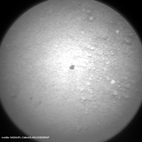
http://makeagif.com/i/geD54y.
The LIBS shots have taken place within a very narrow region. That's an observation type I didn't notice before, might be a new one, probably to get a more representative analysis result over a wider range of mineral grains.
Posted by: Ant103 May 13 2013, 08:43 PM
And my take on this panoramic, after James -good- one 
http://www.db-prods.net/marsroversimages/Curiosity/2013/Sol270_pano.jpg
Posted by: Doc May 14 2013, 10:18 AM

That will be the case according to the http://astrogeology.usgs.gov/news/item/sol-270-update-on-curiosity-from-usgs-scientist-ken-herkenhoff-planning-three-sols. Hence the imaging post-drive.
Posted by: Ant103 May 14 2013, 10:06 PM
Sol 274 Navcam pan taken today is here .
http://www.db-prods.net/marsroversimages/Curiosity/2013/Sol274_pano.jpg
Posted by: fredk May 14 2013, 10:43 PM
Bump forward on 274:
http://mars.jpl.nasa.gov/msl-raw-images/proj/msl/redops/ods/surface/sol/00274/opgs/edr/fcam/FRB_421820853EDR_F0060082FHAZ00302M_.JPG
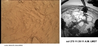
Posted by: EdTruthan May 15 2013, 08:37 PM
These just in from Sol 275...
Mt. Sharp Panorama...
http://www.edtruthan.com/mars/Sol275-Navcam-Mt.Sharp.jpg
and the anaglyph....(yeah baby)...
http://www.edtruthan.com/mars/Sol275-Navcam-Mt.Sharp-Anaglyph.jpg
turret recon at the new location....
http://www.edtruthan.com/mars/Sol275-Front-Hazcam-Turret-Anaglyph.jpg
and - a new MAHLI wheel check!
http://www.edtruthan.com/mars/Sol275-MAHLI-MSL-Wheels.jpg
....gotta love it.
Posted by: Explorer1 May 16 2013, 05:20 AM
Is the drought over? 
Posted by: climber May 16 2013, 08:14 AM
Not sure, they plan to dig another hole in the ground 
BTW, I'd said we'll need to add an "s" to drill or open up a new thread.
Posted by: Ant103 May 16 2013, 11:46 AM
And my take on this wheel MAHLI mosaic :
http://www.db-prods.net/marsroversimages/Curiosity/2013/Sol275_MAHLI.jpg
Posted by: EdTruthan May 16 2013, 08:01 PM
Sol 275 - MC100 four frame mosaic. The new drill site candidate I presume?
http://www.edtruthan.com/mars/Sol275-MC100-Forground.jpg
Posted by: Gerald May 17 2013, 11:06 AM
A Sol 276 animated gif made of two raw Hazcam Front Right B images: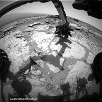
http://makeagif.com/i/tOT_7V
It may provide a certain feeling of a push/release action of the rover arm on the presumed new drill target; the action seems to tilt the rover a bit.
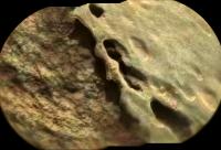
Posted by: marsophile May 17 2013, 05:27 PM
Reply 376 in the "YellowKnife Bay" thread in the yellow blog shows a remarkable change in one of the bumps on Cumberland rock.
Posted by: EdTruthan May 17 2013, 06:31 PM
Thumbing through at the Hazcam sequence from sol 276, I noticed that little "camera jump" too Gerald. The drill was down at the time, and there appears to be a distinct dark diagonal scar in the MAHLI close up of that area on Sol 276 that wasn't there on Sol 275. The contact looks to have been focused on one of the raised nodules. The original raw images are here: http://mars.jpl.nasa.gov/msl-raw-images/msss/00275/mhli/0275MH0258000001R0_DXXX.jpg & http://mars.jpl.nasa.gov/msl-raw-images/msss/00276/mhli/0276MH0168001000C0_DXXX.jpg
http://www.edtruthan.com/mars/M275-276-MAHLI-Comparison.jpg
Posted by: djellison May 17 2013, 06:38 PM
As well it might - they preload with quite a force.
Posted by: EdTruthan May 17 2013, 09:00 PM
Kind of off topic, but does anyone know if the left and right front hazcams actually take their respective stereo images at exactly the same time? The time stamps usually appear as identical with left and right pairs, but is their a slight difference in the actual imaging time of a few milliseconds? I ask because while scrolling through the 14 images taken on Sol 276 (the entire sequence is http://mars.jpl.nasa.gov/msl/multimedia/raw/?s=276&camera=FHAZ_), I noticed a bright "smear" in the sky above Mt. Sharp that appears only on http://mars.jpl.nasa.gov/msl-raw-images/proj/msl/redops/ods/surface/sol/00276/opgs/edr/fcam/FRB_421994401EDR_F0060082FHAZ00206M_.JPG of the sequence. The http://mars.jpl.nasa.gov/msl-raw-images/proj/msl/redops/ods/surface/sol/00276/opgs/edr/fcam/FLB_421994401EDR_F0060082FHAZ00206M_.JPG, lacks this anomaly, as well as all the others in the sequence. The JPL raw image page time stamps both left and right images at "2013-05-16 16:45:59 UTC"
Is this a processing anomaly or a lens glint? If it's a glint then from what? The cameras appear to be in full shadow. Upon closer inspection it seems to almost have a "nucleus" of sorts, (one very bright pixel) and even a wispy looking "tail" associated with it. It certainly seems highly improbable this could be daytime meteor trail, but it almost has that kind of look. If the hazcams take their frames at precisely the same moment then of course it's not or it'd appear on the left image too, correct? . Just wondering what might have caused this because I don't recall seeing many distinct single frame hazcam anomalies (like this one anyway) very often, and it doesn't have a 'digital glitch' look at all due it's wispy nature. Most likely a sun-dog on the lens then? Caused by what though? A reflection off the turret?
http://www.edtruthan.com/mars/Sol276-Right-Hazcam-Anomaly.jpg
... same image with levels tweaked to bring out details:
http://www.edtruthan.com/mars/Sol276-Right-Hazcam-Anomaly-Darkened.jpg
Posted by: elakdawalla May 17 2013, 09:02 PM
When it's a bright streak on one camera and not the other, it's a cosmic ray hit, just like the ones you see on Cassini; you just don't see them as often on Mars, but there's plenty to be found in rover camera images if you look.
Posted by: EdTruthan May 17 2013, 11:05 PM
Thanks Emily. From reviewing several "comic ray hits" on other space images from around the web I'd say you nailed it. They seem to take a wide different forms too, not dissimilar to the one I referenced, as in http://mars.jpl.nasa.gov/msl-raw-images/proj/msl/redops/ods/surface/sol/00113/opgs/edr/ncam/NLA_407549277EDR_F0050432NCAM00538M_.JPG from sol 113. Very similar in pixel spread and appearance. It's placement low over Mt. Sharp is what threw me.
Posted by: Gerald May 17 2013, 11:06 PM
Watchful observation, Ed!
The scar seems to have been caused by the first Sol 276 APXS contact analysis.
Here a more complete animated gif as split screen, which tries to show the Sol 275/276 activities in the correct order. It may help to pin down the cause of the scar:
http://makeagif.com/i/TqOa15.
Sol 277 MAHLI/HazCam image (taken after the "load test") seem to be available just in low-res yet.
Posted by: fredk May 18 2013, 02:38 PM
Like you've been saying about the wheel dents, Emily, cosmic rays come up pretty regularly on this forum too. Maybe a special topic ("It's just a cosmic ray!") or FAQ list would make it easier to deal with.
Posted by: jvandriel May 18 2013, 02:40 PM
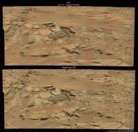
The Navcam NL B panoramic view from images taken on Sol 270 and Sol 275.
Jan van Driel
|
Posted by: EdTruthan May 18 2013, 04:14 PM
With the four Sol 275 MC-34's now in, here's an anaglyph of the recent area of focus. The yellow rectangle outlines the patch being scrutinized by MAHLI imagery of late. The left side of this rectangle is the top in the MAHLI images. And BTW Jan... beautiful work on the Navcam pano with the integration of Mt. Sharp. Nicely done!
http://www.edtruthan.com/mars/Sol275-MC34-100-Forground-Anaglyph.jpg
Posted by: fredk May 18 2013, 05:45 PM
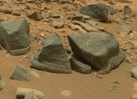
Thanks for the context pic, Ed. It looks like the drilling area may be thick with tasty concretions.
Mmmm, concretions...
Posted by: dvandorn May 18 2013, 05:50 PM
You know, when we first got to Yellowknife Bay, I mentioned that it looked to me like some of the rocks had concretions in them, and Phil (our mapmaker for MSL). whom I much admire, replied with "Concretions, Doug? Really?" Suggesting I was seeing things that weren't there.
Nice to have heard Grotzinger later identified what I was seeing as concretions....
That said, of course, not every little round pebble on Mars is a concretion, and I totally understand caution in making identifications at first glance.
-the other Doug
Posted by: Phil Stooke May 18 2013, 06:41 PM
Hmm, so I can be wrong!
Phil
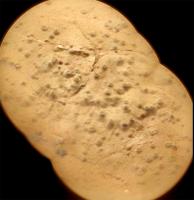
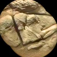
Posted by: Zelenyikot May 19 2013, 12:29 PM
Cumberland in colored ChemCam on Sol 277
|
Posted by: Phil Stooke May 19 2013, 04:36 PM
Very nice - I am glad to see some more of these.
Phil
Posted by: Actionman May 19 2013, 11:35 PM
What do you see in this now Phil?
Posted by: Actionman May 20 2013, 02:05 PM
Disregarding these what it looks like we now have two large lens artifacts on MAHLI.
http://mars.jpl.nasa.gov/msl-raw-images/msss/00279/mhli/0279MH0190001000C0_DXXX.jpg
(edit: from photo too link)
Posted by: mcaplinger May 20 2013, 02:16 PM
Huh? Are you talking about sensor crud? Prove to me that you see something that hasn't been there since before launch.
Posted by: Gerald May 20 2013, 02:29 PM
I can also see a new artifact.
This one: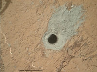
http://makeagif.com/i/9tTSlM
Posted by: Actionman May 20 2013, 04:38 PM
why yes?
I have not decided on endeavor of reaches but the question of black particles seem critical and new flat field data seems appropriate.
Posted by: EdTruthan May 20 2013, 05:48 PM
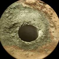
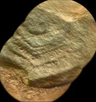
Sol 279 -
Close-up anaglyph of the drill hole. Seems to my eyes they offset MAHLI just enough for a good human eye separation value. Lots of detail in here. The anaglyph at least feels like kneeling just above the site. And there's a http://www.jpl.nasa.gov/video/index.php?id=1217 (May 16th, 2013) about drill sample processing. Gives a good idea of the drill size when Avi Okon is holding it in his hand...
http://www.edtruthan.com/mars/Sol279-MAHLI-Drill-Hole-Anaglyph.jpg
Here's a cross-eye view for those without anaglyph specs....
http://www.edtruthan.com/mars/Sol279-MAHLI-Drill-Hole-Cross-Eye.jpg
Posted by: Gerald May 20 2013, 08:48 PM
A zoom-in to the Cumberland drill hole created from http://mars.jpl.nasa.gov/msl-raw-images/proj/msl/redops/ods/surface/sol/00279/opgs/edr/ncam/NRB_422269576EDR_F0060082NCAM00375M_.JPG patched with http://mars.jpl.nasa.gov/msl-raw-images/msss/00279/mhli/0279MH0267001000C0_DXXX.jpg: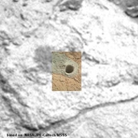
http://makeagif.com/i/USwOui.
Posted by: mcaplinger May 20 2013, 09:26 PM
I have not decided on endeavor of reaches but the question of black particles seem critical and new flat field data seems appropriate.
I can't parse this completely, but note that these are raw images without any flat-field correction. I was unable to find any sensor crud in this image that wasn't there before launch.
Posted by: ElkGroveDan May 20 2013, 09:58 PM
http://mars.jpl.nasa.gov/msl-raw-images/msss/00279/mhli/0279MH0190001000C0_DXXX.jpg
(edit: from photo too link)
If you have an observation that you'd like to share, please point out what you are talking about, otherwise your post is useless.
Posted by: brellis May 20 2013, 11:59 PM
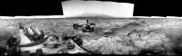
In the Sol 275 PanCam image Emily uses in her recent (wonderful as always!) PS blog updating status for Curiosity there are mountains in the distance to the right of Mt Sharp. Probably a silly question: is that the rim of Gale Crater?
https://planetary.s3.amazonaws.com/assets/images/4-mars/2013/20130520_Sol274_pano.jpg
Posted by: dvandorn May 21 2013, 12:29 AM
Yep.
-the other Doug
Posted by: Gerald May 21 2013, 10:01 AM
Drilling the Sol 279 hole in time-lapse, as seen from Hazcam Front Left B:
http://makeagif.com/XAl1fD.
(EDIT: Sorry Paul for being almost perfectly in sync with your work https://www.facebook.com/marscuriosityimages. This wasn't intended.)
Posted by: Gerald May 21 2013, 02:08 PM
Drill powder vibrated in scoop, Sol 279:
http://makeagif.com/i/Ca30Dv.
Posted by: Phil Stooke May 21 2013, 06:06 PM
Great big round things!
Sorry for the delayed reply - I'm travelling... in Vancouver again for a couple of weeks and only just got set up with internet.
Phil
Posted by: EdTruthan May 21 2013, 11:19 PM
Sol 279 - MC34/MC100 anaglyph of the drill area in nice context with the immediate surroundings...
http://www.edtruthan.com/mars/Sol279-MC34-MC100-Drill-Area-Anaglyph.jpg
Posted by: Gerald May 22 2013, 07:17 AM
Seems, as if they applied the complex ChemCam LIBS pattern, observed on Sol 271, http://mars.jpl.nasa.gov/msl-raw-images/proj/msl/redops/ods/surface/sol/00281/opgs/edr/ccam/CR0_422435033EDR_F0060082CCAM01281M_.JPG.
Holes now look larger than in pre-conjunction.
EDIT: ... ok, I should give you a GIF: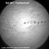
http://makeagif.com/nfs57L.
Posted by: djellison May 22 2013, 02:02 PM
Hole fired closed to the rover will 'look bigger'.
Posted by: Gerald May 22 2013, 08:09 PM
That's true. So we have to check the distance.
HazCam Right B is fixed to the rover, so comparing the y-pixel position of the two targets in respective Hazcam images should give a good comparison of the respective rover position to the target, as long as the x-position is near the center, plane ground assumed in both cases.
The following gif based on the Hazcam images for http://mars.jpl.nasa.gov/msl-raw-images/proj/msl/redops/ods/surface/sol/00234/opgs/edr/fcam/FRB_418255767EDR_F0060000FHAZ00323M_.JPG and http://mars.jpl.nasa.gov/msl-raw-images/proj/msl/redops/ods/surface/sol/00280/opgs/edr/fcam/FRB_422337542EDR_F0060082FHAZ00325M_.JPG helps to compare the two y-pixel positions:
http://makeagif.com/i/g1m0MA.
The y-pos of the targets is almost the same to my eyes.
Cited from http://www.msl-chemcam.com/index.php?menu=inc&page_consult=textes&rubrique=64&sousrubrique=224&soussousrubrique=0&art=259&titre_url=ChemCam%20-%20How%20does%20ChemCam%20work?&step=2#.UZ0X7NJFCSo:
Hence, to get the same pointing of the RMI the mast position relative to the rover, and therefore the distance to the target should be roughly the same for both ChemCam images. This was to check.
Posted by: fredk May 22 2013, 08:31 PM
I'm sure that the size of the laser mini-craters depends on the surface properties - some surfaces will exhibit larger craters than others with everything else fixed.
Posted by: EdTruthan May 23 2013, 12:06 AM
Sol 281 - MC34/MC100 anaglyph of ChemCam hits on new drill tailings...
http://www.edtruthan.com/mars/Sol281-ChemCam-Holes-Drill-Site-2.jpg
Posted by: PaulH51 May 23 2013, 02:00 AM
Agreed Gerald, the distance appears to be the same. Maybe they have established an optimal distance from the rover to the target when drilling. The crater size could also be a result of more laser strikes on each target, or the Cumberland drill cuttings could contain a compound that is more reactive to the resulting plasma which ejects more material. Hopefully they will discuss these issues when they release the results.
Posted by: Phil Stooke May 23 2013, 04:06 AM
"Maybe they have established an optimal distance from the rover to the target when drilling"
The design of the arm, and the force required to be applied during drilling, probably dictate that distance within rather narrow limits.
Phil
Posted by: djellison May 23 2013, 04:33 AM
Indeed they do.
Posted by: Gerald May 23 2013, 09:10 AM
Here the corresponding before/after blink (Sols 279/281):

http://makeagif.com/i/TPw5xA.
EDIT: ... and as cross-eye stereo, if you like:

http://makeagif.com/i/Wkgut7.
Posted by: effects May 23 2013, 04:18 PM
I am curious about the small light coloured object that is visible in Gearald's blink gif (post #57). It is located just over 3/4 of the way down and just left of center in the image(s). It changes position between the two images. It appears to be the only object displaced by the laser or perhaps the wind.
Posted by: fredk May 23 2013, 05:28 PM
Judging by its colour, it's a shard of drill tailings being moved a bit by the wind. If you look closely, you can see other bits of grey tailings shift around a bit between the frames, although you have to be careful because the lighting is different between the frames.
Posted by: djellison May 23 2013, 05:47 PM
Look more closely - I see at LEAST 15 little bits of drill tailings blowing around. Infact, since making the GIF I see loads more.
This surface has had nothing to do but get used to wind patterns for hundreds of millions of years. Then along we come and drill a hole in it, dump tailings on it, fire a laser at it.....you're going to see motion of that material in the wind.
Doug

|
Posted by: fredk May 24 2013, 02:43 PM
Some action on sol 284 - make your favourite laser sounds!
|
(That's three frames - before, during, and after. You can see the little scar when it jumps back to frame 1 after frame 3.)
Posted by: effects May 24 2013, 04:17 PM
Thank you for the explanation. You guys are amazing!
Posted by: Gerald May 24 2013, 04:21 PM
(Sorry for delay, investigation took some time.)
Here a well-documented http://pds-geosciences.wustl.edu/msl/msl-m-chemcam-libs-4_5-rdr-v1/mslccm_1xxx/browse/sol00072/qchemcam_00072_rmi_403881653.jpg.
That hole was the result of a 3x3 raster with 10 laser shots at each raster point. (Metadata in file msl_ccam_obs.csv in http://pds-geosciences.wustl.edu/msl/msl-m-chemcam-libs-4_5-rdr-v1/mslccm_1xxx/document/.)
May be the ChemCam shots on the Cumberland drill tailings were carried out in a similar way.
Posted by: Gerald May 24 2013, 05:06 PM
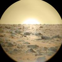
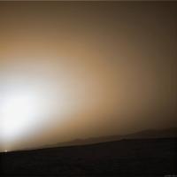
Impression of Martian sunset on Sol 283:
http://makeagif.com/i/oXbLcV
Posted by: Phil Stooke May 24 2013, 07:11 PM
Really nice - thanks for doing these GIFs.
Phil
Posted by: Gerald May 24 2013, 09:24 PM
Many people have been working together to make it possible, most of them in the background.
Posted by: PaulH51 May 25 2013, 01:09 AM
High probability that that could be the reason, I am sure there would be much to learn from the different results from the surface and those at depth. Maybe they will target the inner wall of the hole again?
So all we have to do is await the future PDS release of the data to confirm if they did cluster tests here at Cumberland
Posted by: Ant103 May 25 2013, 09:04 AM
Sol 283 Mastcam34 mosaic of Cumberland Hole drill & ChemCam shots are clearly visible.
http://www.db-prods.net/marsroversimages/Curiosity/2013/Sol283_Mastcam34.jpg
Posted by: Gerald May 25 2013, 07:43 PM
Sol 283 MAHLI stitch with some more details, a region in the center with higher resolution:
http://i.imgbox.com/acyhnu10.jpg.
Free Image Hosting by imgbox.com
For the higher resultion region portions of http://mars.jpl.nasa.gov/msl-raw-images/msss/00283/mhli/0283MH0184001000C0_DXXX.jpg have been used.
Posted by: Gerald May 26 2013, 08:45 AM
Yep:
|
Grey-stretched region of http://mars.jpl.nasa.gov/msl-raw-images/proj/msl/redops/ods/surface/sol/00285/opgs/edr/ccam/CR0_422792706EDR_F0060082CCAM07284M_.JPG.
Posted by: PaulH51 May 26 2013, 09:11 AM
Grey-stretched region of this Sol 285 ChemCam image[/url].
The accuracy the engineering team can achieve when targeting the laser never ceases to amaze me
Posted by: Zelenyikot May 26 2013, 09:35 AM
Colored ChemCam of a drilled hole. Sol 285
|
Posted by: Gerald May 26 2013, 09:37 AM
... Sample on observation tray on Sol 284
(http://makeagif.com/i/IJD69c)
Paul, you already pointed to https://www.facebook.com/marscuriosityimages
and ChemCam focussing to the horizon on Sol 285:
(http://makeagif.com/i/FChQHJ).
They were really busy this week! And SAM analysis is also running.
Posted by: PaulH51 May 26 2013, 10:55 AM
Not sure if that is a first? But it is certainly the first time I have noted them using ChemCam in that fashion...
I thought we might have been observing a sunset, but that appears to be ruled out by the time-stamps on the images, maybe a lens effect?
Posted by: Gerald May 26 2013, 11:25 AM
The really exciting thing for me is, that this series of ChemCam images can be used for focus stacking.
Here my first try:
http://i.imgbox.com/abdPSaPM.jpg. (Edit: exchanged URL)
Posted by: Zelenyikot May 26 2013, 12:47 PM
Colored ChemCam horizon and imitation colored sunset.
|

|
Posted by: Gerald May 26 2013, 12:58 PM
Great! I knew, you would do colorizing.
Although the sun in this case is an artifact.
Posted by: PaulH51 May 26 2013, 02:09 PM
Here my first try:
http://hcd-1.imgbox.com/abdPSaPM.jpg?st=F_n7ukDQRgsgt0AYNbpk6Q&e=1369569391.
Getting a "403 Forbidden" on that link, could be an Imgbox issue? can you please re-post Gerald? TIA
Posted by: Gerald May 26 2013, 02:23 PM
Thanks! Strange, it works for me.
Does http://i.imgbox.com/abdPSaPM.jpg work?
If not, here a copy hosted on UMSF, it's not too large:
|
Posted by: fredk May 26 2013, 05:11 PM

Posted by: PaulH51 May 26 2013, 09:36 PM
Does http://i.imgbox.com/abdPSaPM.jpg work?
If not, here a copy hosted on UMSF, it's not too large:
Got it this time, thanks
Nice image...
Posted by: PaulH51 May 26 2013, 09:40 PM
Many thanks for the explanation
Posted by: Gerald May 28 2013, 12:51 PM
This post is a rather subtle one. And it's no joke.
The following animated gif looks like one single image. But it isn't. Actually it's a made of the first 20 images of a Sol 284 Mastcam Left video sequence. You may notice the camera noise when looking very closely to your screen.
http://makeagif.com/0Fe15v.
There is a synchronous sequence of Mastcam Right images. So there is the potential for a 3d Mastcam video movie.
Posted by: PaulH51 May 28 2013, 01:58 PM
....There is a synchronous sequence of Mastcam Right images. So there is the potential for a 3d Mastcam video movie.
Now I have a valid excuse to invest a good pair of 3D glasses
Good call Gerald! Looks like I was barking up the wrong tree (yet again!) after I first saw this series of images
Posted by: MahFL May 28 2013, 05:26 PM
Is that part of the rover swaying in the wind ?
Posted by: elakdawalla May 28 2013, 06:26 PM
You're looking there at part of the sample handling subsystem, the bit that portions out the tiny amount that goes into SAM and Chemin. If they shot video of it there's likely a couple of frames that actually contain a sample dropping. I don't have time to download and look for it myself.
Posted by: Gerald May 28 2013, 07:45 PM
I couldn't find any other changes as image noise in the 48 images video sequence. So it may be a reference run to compare it later with an actual sample dropping, and to test camera sync and position. Could also be used to determine camera S/N.
A future run might be used to verify successful sample dropping and the influence of wind.
At the moment this is speculative. We've to wait.
Posted by: Explorer1 May 28 2013, 11:58 PM
Press-con on the 30th, 11:30 PST, on RAD findings.
http://www.jpl.nasa.gov/news/news.php?release=2013-176
Posted by: Gerald May 29 2013, 12:17 PM
Probably extensive APXS measurements on Cumberland drill tailings, e.g. on Sols 287/288:
http://makeagif.com/i/HUbvrL.
Long lasting APXS measurements have been carried out by Opportunity to infere the presence of light chemical elements (meaning lighter than sodium, i.e. the first two rows of the http://en.wikipedia.org/wiki/Periodic_table).
Cited from the PS blog http://www.planetary.org/explore/space-topics/space-missions/mer-updates/2013/05-mer-special-update-opportunitys-findings-at-endeavour-crater-so-far.html:
It should be interesting to compare APXS with SAM findings. So e.g. volatile compounds of light elements could be compared with non-volatile ones.
Posted by: Zelenyikot May 29 2013, 02:06 PM
Dust on body: 14, 90, 196, 286 sols.

|
Posted by: Gerald May 30 2013, 09:44 PM
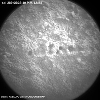
After APXS, returning to ChemCam activities in the early afternoon of Sol 289:
On drill tailings: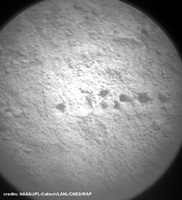
(http://makeagif.com/i/tZCIRE)
In a (probably) 3x3 raster on or close to mostly rounded grains up to about the size of fine gravels:
(http://makeagif.com/i/83o2Jy)
Posted by: Gerald May 31 2013, 09:23 AM
http://makeagif.com/i/XC0o7d.
Fortunately, this time USGS Scientist Ken Herkenhoff provides the explanation, better than I ever could, in http://astrogeology.usgs.gov/news?id=news/sol-289-update-on-curiosity-from-usgs-scientist-ken-herkenhoff-heating-up:
Thanks Paul, for pointing to Ken Herkenhoff's update via PM!
Posted by: PaulH51 May 31 2013, 11:08 AM
Thanks Paul, for pointing to Ken Herkenhoff's update via PM!
Nice Gif Gerald, I've re-published it on the FB page.
Probably be some time before we see the formal results for the presence of hydrogen. So time for a little speculation here
The early morning image of the laser strike area is much larger and appears to have a different profile than any of the earlier laser strikes on drill tailings. It actually looks more like an impact crater.
So I speculate that the test may show that some moisture (maybe a heavy overnight frost?) was present on or within the surface which resulted in the generation of large quantity of gas by the laser induced plasma which vigorously ejected the surface materials resulting in the formation of this mini crater.
Only 1 theory, let's see if anyone has a better one
Posted by: nprev May 31 2013, 11:16 AM
That's a bit of a leap, to be frank about it.
There may well be hydrated minerals present but ice itself...no evidence at all to support that as of yet, and an atypical laser crater by itself does not constitute direct evidence.
They might have blasted it twice, perhaps? In any case, I'm sure we'll find out what's going on from the science team in due time.
Posted by: Airbag May 31 2013, 08:20 PM
Hmm, literally hundreds of Sol 289 http://www.midnightplanets.com/web/MSL/image/00289/0289ML0962000996M0_DXXX.htmlML thumbnails coming down of this exact same CHIMRA location (at least based on the pointing info):
http://mars.jpl.nasa.gov/msl-raw-images/msss/00289/mcam/0289ML0961000000E1_DXXX.jpg
I wonder what that was all about? [edit: almost as if a "movie" was intended, but the exposure went wrong for all but the first image?]
Airbag.
Posted by: Gerald May 31 2013, 11:19 PM
The timestamps and the large number of images support the movie idea. Looks a bit like a slow motion experiment.
It's nevertheless hard to infere without more infos from the team.
Posted by: mcaplinger Jun 1 2013, 03:39 AM
Unfortunately there is no public information I can point you to about all the video modes and options; this information will be in the PDS release which by the schedule should occur next month. For now I'll just say that your conjectures are perfectly reasonable.
Posted by: Gerald Jun 1 2013, 09:15 AM
Thanks a lot, Mike! So we'll get details about those capabilities soon.
And thanks Paul, for pointing to the newly downlinked Sol 284 MastCam Left sample dropping images via PM! Here the according animated gif. It's animated with 125 ms delay, hopefully in real-time:
http://makeagif.com/i/3n6_rY.
So Emily, you were right, at the end.
Links to the two most interesting raw images of the sequence:
http://mars.jpl.nasa.gov/msl-raw-images/msss/00284/mcam/0284ML0965000155M0_DXXX.jpg
http://mars.jpl.nasa.gov/msl-raw-images/msss/00284/mcam/0284ML0965000156M0_DXXX.jpg
Posted by: Gerald Jun 1 2013, 02:48 PM
... this makes me curious, whether we'll later be able to enjoy a Mastcam Left movie following a falling sample in slo-mo, as this Sol 289 empty run might roughly suggest:
http://makeagif.com/i/chokDS.
Such a movie could certainly provide additional information about the analysed powder.
Posted by: xflare Jun 2 2013, 07:57 AM
So, I believe they will be taking a closer look at the Shaler formation when they leave this regioin, does anyone think they might also want to take another look at the Hottah and Link conglomerates. They only took Mascam images of them so some microscope shots would be very interesting.
Posted by: Gerald Jun 2 2013, 11:57 AM
Cited from http://www.spaceflight101.com/msl-mission-updates-6.html, May 10, 2013:
I'm not aware of much more details published yet, about the way back from Glenelg.
A closer look to the conglomerates sounds rather plausible, not just at the locations already visited, but also on the way to Mt. Sharp. The size, shape and distribution of the clasts will tell more about the processes by which they were formed, e.g. the length, inclination, and depth of potential rivers.
I wonder, whether the cratered section of Glenelg will also be visited, and whether the surface layer of the cratered section will turn out to be older or younger than Yellowknife Bay, or both, meaning older sedimentation at YB, and younger erosion, or more complicated. We'll see, whether they decide to collect more geologic data at Glenelg, before they'll start their way back. As the mission is mainly "discovery-driven" it will depend on actual findings.
Posted by: mcaplinger Jun 2 2013, 03:47 PM
Depends on what you mean by "slo-mo". If I take a 1 frame/sec movie and play it back at 1/2 frame/sec than that's technically "slow motion" but it will look pretty jerky. The Mastcam frame rate at 720P resolution is only something like 10 fps, and even tiny subframes can only speed that up so much. I wouldn't call the results "slo-mo" relative to the standard commercial 30 fps video rate.
Posted by: Gerald Jun 2 2013, 06:32 PM
On the http://mars.jpl.nasa.gov/msl/multimedia/raw/?s=289&camera=MAST_, I've been counting 32 fps (tiny 224x128 frames), e.g. for 2013-05-30 06:14:04 UTC and 2013-05-30 06:14:05 UTC. That's four fold relative to the probably 8 fps of the sol 284 sequences.
If pointed successfully with the dropping sample, somewhere between 4 and 8 images of the sample might be achievable, with reduced motion blur.
Such a sequence could - in an optimal case - be adjusted/registered and animated in a way, that the sample looks like hovering.
Posted by: Phil Stooke Jun 2 2013, 08:49 PM
Looks like a DRT brush job on sol 291 - MAHLI thumbnails show it. Full resolution soon, I hope.
Phil
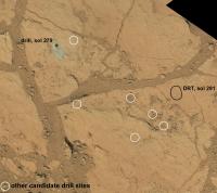
Posted by: Phil Stooke Jun 3 2013, 12:15 AM
A quick little map of the Cumberland area showing the drill site, the other candidate drill sites from a recent video update, and the new DRT location.
Phil
|
Posted by: Phil Stooke Jun 3 2013, 12:47 PM
... to which I can now add the location of the fractured nodule from sol 276, apparently due to contact with the APXS.
Phil

|
Posted by: Gerald Jun 3 2013, 03:31 PM
Phil
Before/after blink now available:

http://makeagif.com/i/E2Ms6L
More context in http://mars.jpl.nasa.gov/msl-raw-images/msss/00291/mhli/0291MH0197001001C0_DXXX.jpg.
Posted by: Phil Stooke Jun 3 2013, 08:16 PM
Drive away next week! (probably meaning this week, in fact) - and night-time imaging of the hole with LEDs :
http://astrogeology.usgs.gov/news?id=news/sol-291-update-on-curiosity-from-usgs-scientist-ken-herkenhoff-the-drill-hole-walls
Thank you Ken!
Phil
Posted by: Phil Stooke Jun 4 2013, 12:51 AM
... and a telecon on Wednesday:
http://www.jpl.nasa.gov/news/news.php?release=2013-185
Phil
Posted by: fredk Jun 4 2013, 05:33 PM
Very cool thumbs down showing LED illumination from mastcam: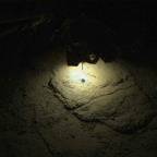
Posted by: Phil Stooke Jun 4 2013, 05:46 PM
Wow, that is cool.
Phil
Posted by: Gerald Jun 4 2013, 06:16 PM
Looking forward to the hires version of those cool pocket lamp night shots.
In the meanwhile twiddling with the Sol 291 "air brush":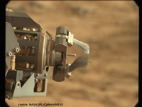
http://makeagif.com/i/khKOGz
Posted by: Ant103 Jun 4 2013, 10:05 PM
Finally, they've done it This "campfire" picture I was dreaming of, the first time I saw the MAHLI's pictures showing the ground illuminated by its LEDs . Can't wait to see the full resolution \o/
Posted by: Gerald Jun 5 2013, 02:27 PM
Swinging along a line in a two-dimensional http://en.wikipedia.org/wiki/Phase_space:
http://makeagif.com/i/cClmJH.
The endpoints of the line are the two Sol 292 MAHLI images http://mars.jpl.nasa.gov/msl-raw-images/msss/00292/mhli/0292MH0283001000C0_DXXX.jpg and http://mars.jpl.nasa.gov/msl-raw-images/msss/00292/mhli/0292MH0283002000C0_DXXX.jpg.
The single images of the sequence were obtained by superposing due to the formula
superposed = a * image1 + (1-a) * image2, for values of a between 0 and 1.
This superposition results in images, which are very narrow to images which could have been obtained with two "dimmed" LEDs at night.
Posted by: mhoward Jun 5 2013, 04:16 PM
Gerald: It's a nice result, but I think you could have just said "I interpolated between two Sol 292 MAHLI images http://mars.jpl.nasa.gov/msl-raw-images/msss/00292/mhli/0292MH0283001000C0_DXXX.jpg and http://mars.jpl.nasa.gov/msl-raw-images/msss/00292/mhli/0292MH0283002000C0_DXXX.jpg" and been done. Many people here are familiar with the concept.
Posted by: Explorer1 Jun 5 2013, 06:32 PM
Telecon starting now....
http://www.ustream.tv/nasajpl
Media: http://www.nasa.gov/mission_pages/msl/telecon/index.html
Posted by: Phil Stooke Jun 5 2013, 06:50 PM
... and I quit listening when Boyle asked about the rat.
Phil
Posted by: elakdawalla Jun 5 2013, 10:15 PM
http://www.planetary.org/blogs/emily-lakdawalla/2013/06051352-curiosity-update-sol-295.html (it did contain a couple of useful tidbits after Alan's question!). Since this thread hasn't existed for very long, I'm going to suggest we keep using it for the wrapup work at Point Lake and Shaler and then switch to a new thread once they really hit the road in a few weeks.
Posted by: Ant103 Jun 6 2013, 11:56 AM
Sol 295 little bump, before roving for good
http://www.db-prods.net/marsroversimages/Curiosity/2013/Sol296_pano.jpg
Posted by: eoincampbell Jun 6 2013, 05:39 PM
Are they taking DAN measurements of the Cumberland spot now? I don't remember the John Klein drill spot being DANed...
Posted by: Phil Stooke Jun 6 2013, 05:45 PM
It wasn't, but maybe it will be after this.
Phil
Posted by: elakdawalla Jun 6 2013, 11:20 PM
In yesterday's briefing they said they were doing a DAN traverse, both active and passive, across the geologic contact between Sheepbed and Gillespie units. Both John Klein and Cumberland are Sheepbed unit.
Posted by: Zelenyikot Jun 6 2013, 11:42 PM
My try to unwrap walls of drill hole.
|
|
Posted by: Phil Stooke Jun 6 2013, 11:43 PM
Very interesting and ingenious idea!
Phil
Posted by: Ant103 Jun 7 2013, 12:14 PM
Sol 297. An other move .
http://www.db-prods.net/marsroversimages/Curiosity/2013/Sol297_pano.jpg(Maybe it will good to start an other thread ? We have stop to drill at Cumberland and we're going to rove, no ?)
Okay, thanks for your precision Paul
Posted by: PaulH51 Jun 7 2013, 01:06 PM
.(Maybe it will good to start an other thread ? We have stop to drill at Cumberland and we're going to rove, no ?)
Damia,
Nice Pano, note that Emily posted this yesterday
Posted by: Phil Stooke Jun 7 2013, 02:34 PM
Damia's pan in circular format to show where we are.
Phil

|
Posted by: mhoward Jun 7 2013, 03:19 PM
She's pointed directly at "Point Lake". It'll be fun to see if her next drive is right up and over the shelf.
Posted by: wildespace Jun 7 2013, 04:24 PM
Decided to have a go at focus-stacking (never tried that before), seeing how there are two night-time images suitable for this: http://mars.jpl.nasa.gov/msl/multimedia/raw/?rawid=0292MH0280000000C0_DXXX&s=292 and http://mars.jpl.nasa.gov/msl/multimedia/raw/?rawid=0292MH0280002000C0_DXXX&s=292

|
Used CombineZP for this, and also adjusted the colour-balance afterwards. The LEDs seem to give the images a cyan cast. I wish there were an intermediate image, as some of the hole's wall is out of focus on both images.
Posted by: Phil Stooke Jun 8 2013, 03:32 AM
I love these night-time images:
http://www.midnightplanets.com/web/MSL/image/00292/0292MR1233000000E1_DXXX.html
Phil
Posted by: Ant103 Jun 8 2013, 02:01 PM
Version with the less hot pixels possible, and denoising. And a litte enhancemnt by tone-mapping .
http://www.db-prods.net/marsroversimages/Curiosity/2013/0292ML1233001000E1_DXXX_denoised_tone.jpg
Posted by: jvandriel Jun 8 2013, 02:07 PM
The Navcam view on Sol 0289 and
added images taken on Sol 0275.
Jan van Driel

|
Posted by: EdTruthan Jun 8 2013, 08:32 PM
A Few Anaglyphs of recent activities...
Sol 292 - Cumberland drill hole night shot MC34/MC100 pairing- The MC34 image was unrecoverably overexposed where hotly illuminated but it still makes for a pretty nice stereo view....
http://www.edtruthan.com/mars/Sol292-Cumberland-Drill-Hole-Night-Anaglyph.jpg
Sol 297 - Animated GIF of MSL drive movements from front hazcam - total of four frames (at different positions) with a 3 seconds pause for each...
http://www.edtruthan.com/mars/Sol297-Front-Hazcam-MSL-Movment-Animated-Anaglyph.gif
Sol 297 - Navcam panorama from the new location after the short drive...
http://www.edtruthan.com/mars/Sol297-Navcam-Pano-Anaglyph.jpg
It's great to be moving again... even if just a few meters for now...
Posted by: wildespace Jun 9 2013, 08:26 PM
Interesting rock in the Sol 297 Mastcam 100 mosaic.
http://mars.jpl.nasa.gov/msl/multimedia/raw/?rawid=0297MR1243005000E1_DXXX&s=297

|
I presume it's white, some sort of calcium deposit perhaps? Would be nice to see a MAHLI shot of it.
Posted by: nprev Jun 9 2013, 08:53 PM
Interesting! Could be a lot of stuff; many compounds are white.
Possibly some sort of depositional mineral, which if true might indicate a fairly long period of liquid water presence.
Posted by: EdTruthan Jun 10 2013, 01:28 AM
A few more Sol 297 images....
Upper section of a long vertical Sol 297 MC100 mosaic - with that interesting rock at lower right; some nice details throughout this one...
http://www.edtruthan.com/mars/Sol297-MC100-Partial-Pano.jpg
...and an anaglyph of the lower portion of the above, using the available overlapping MC34 coverage...
http://www.edtruthan.com/mars/Sol297-MC100-Partial-Pano-Anaglyph.jpg
Posted by: CosmicRocker Jun 10 2013, 03:59 AM
http://mars.jpl.nasa.gov/msl/multimedia/raw/?rawid=0297MR1243005000E1_DXXX&s=297
...
Thanks. Nice catch. I have a difficult time keeping up with all the imagery, but the Mastcam 100s are the best!
It looks like an interesting exposure of the light-colored fracture fillings displaying their three dimensional structure.
Posted by: Phil Stooke Jun 10 2013, 02:41 PM
PDS says the new release is out! - I'm still waiting for the Analyst's Notebook part of it.
Phil
Posted by: PaulH51 Jun 11 2013, 12:08 PM
Sol 301 Update On Curiosity From USGS Scientist Ken Herkenhoff:
http://astrogeology.usgs.gov/news?id=news/sol-301-update-on-curiosity-from-usgs-scientist-ken-herkenhoff-recovery-sequence
Posted by: Ant103 Jun 11 2013, 04:12 PM
Sols 300 and 301 Navcam panoramics
http://www.db-prods.net/marsroversimages/Curiosity/2013/Sol300_pano.jpg
http://www.db-prods.net/marsroversimages/Curiosity/2013/Sol301_pano.jpg
It's good to see her moving again .
And a Mastcam100 mosaic of Point Lake, on Sol 300 :
http://www.db-prods.net/marsroversimages/Curiosity/2013/Sol300_Mastcam100.jpg
Posted by: Phil Stooke Jun 11 2013, 11:12 PM
These are circular versions of Ant103's new navcam pans:
sol 300

|
sol 301

|
Phil
Posted by: Jam Butty Jun 12 2013, 01:30 AM
Some nice erosion features
Mastcam Sol 298
flicker gif...

|
crossed pair...

|
Posted by: fredk Jun 12 2013, 02:25 AM
Nice, Jam.
I like the little spout that sand is spilling into as it works it's way down to the lower level in http://mars.jpl.nasa.gov/msl-raw-images/msss/00298/mcam/0298MR1248000000E1_DXXX.jpg That's one little spot where change on geological timescales gets concentrated and focused until it might even be visible in real time - you might occasionally see a bit of sand spill down.
Posted by: EdTruthan Jun 12 2013, 04:27 PM
Sol 300 - Anaglyph of the mastcam panorama. There also a big pano from Sol 298 that's got some very interesting close-ups of the nearby geology that's still missing a few frames. Jam Butty's images above are from that series. Will post full versions when the missing frames are in....
http://www.edtruthan.com/mars/Sol300-MC100-MC34-Outcrop-Anaglyph.jpg
Posted by: Ant103 Jun 12 2013, 08:49 PM
We're getting a little bit more closer to Point Lake on Sol 302
http://www.db-prods.net/marsroversimages/Curiosity/2013/Sol302_pano.jpg
Posted by: Phil Stooke Jun 12 2013, 09:02 PM
Very nice spot for a short stop. Here it is, from Ant103's pan, in circular format.
Phil

|
Posted by: Zelenyikot Jun 12 2013, 10:19 PM
Colored ChemCam on Sol 302
(Colors is not good because Point Lake is too far on MastCam pan on Sol 298)

|
Posted by: PaulH51 Jun 12 2013, 11:07 PM
Maybe as close as we get... note this extract from : Sol 302 Update On Curiosity from USGS Scientist Ken Herkenhoff:-
http://astrogeology.usgs.gov/news?id=news/sol-302-update-on-curiosity-from-usgs-scientist-ken-herkenhoff-point-lake-outcrop
Posted by: Ant103 Jun 13 2013, 03:46 PM
Color mosaic of Point Lake rocks, Sol 302 :
http://www.db-prods.net/marsroversimages/Curiosity/2013/Sol302_Mastcam34.jpg
Posted by: Gerald Jun 13 2013, 03:58 PM
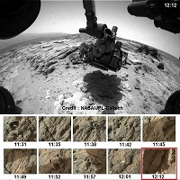
Sol 303 Navcam flicker of a target at Point Lake:
http://makeagif.com/i/rOntLY.
And here two links to fascinating (subjective) MAHLI close-ups:
http://mars.jpl.nasa.gov/msl-raw-images/msss/00303/mhli/0303MH0293001000E1_DXXX.jpg
http://mars.jpl.nasa.gov/msl-raw-images/msss/00303/mhli/0303MH0294001000E1_DXXX.jpg.
Posted by: Zelenyikot Jun 13 2013, 11:02 PM
New images of "http://www.unmannedspaceflight.com/index.php?s=&showtopic=7591&view=findpost&p=197540"
NavCam on Sol 300
http://www.keepme.ru/fT
and http://mars.jpl.nasa.gov/msl/multimedia/raw/?rawid=0301ML1252000000E2_DXXX&s=301 on Sol 301. Unfortunatly http://mars.jpl.nasa.gov/msl/multimedia/raw/?rawid=0301MR1252001000E1_DXXX&s=301 didn't take this object.
|
Posted by: Astro0 Jun 13 2013, 11:28 PM

|
Doesn't need words, it's just nice.
Posted by: James Sorenson Jun 14 2013, 06:09 AM
Point Lake is ready for its closeup.
http://www.flickr.com/photos/43581439@N08/9037911783/
Posted by: xflare Jun 14 2013, 08:14 AM
What are people making of the rocks at Point Lake? There seem to be lots of small pebbles/rocks embedded in it. Some are white, some dark.
http://mars.jpl.nasa.gov/msl-raw-images/msss/00302/mcam/0302MR1257010000E1_DXXX.jpg
Posted by: Ant103 Jun 14 2013, 10:18 AM
Yes, spectacular rocks. A lot of holes, many circulars. This is rare when rocks amaze me like this .
(My take on this Mastcam100 mosaic)
http://www.db-prods.net/marsroversimages/curiosity-2013.html#63
Posted by: Gerald Jun 14 2013, 12:32 PM
While waiting for the full resolution focus-stacked version of the sol 303 MAHLI images, here a focusing gif of one of them, twice the size of the raw thumbnails:
http://makeagif.com/i/xNW4mX.
The largest of the embedded pebbles looks rounded/subrounded, but clearly non-convex, with some void between matrix and pebble (clast?).
Posted by: Gerald Jun 14 2013, 02:37 PM
Sol 303 MAHLI activities as seen from Front Hazcam Left B:
http://makeagif.com/i/98QEtY.
Posted by: spiritofgusev Jun 14 2013, 04:40 PM
http://mars.jpl.nasa.gov/msl-raw-images/msss/00302/mcam/0302MR1257010000E1_DXXX.jpg
Relic of hot mud splashed against the surface from an impact event?
Posted by: tdemko Jun 14 2013, 05:00 PM
Inversely-graded, matrix-supported to clast-supported debrite, deposited by a muddy debris flow with various clasts that included armored iceballs (ice now long sublimated)?
Posted by: Phil Stooke Jun 14 2013, 05:19 PM
Sounds good - and the flow might also be ejecta (small impact, later stages of excavation, not heated very much) to allow ice fragments to survive without too much degradation - i.e. they don't have to come all the way from Peace Vallis. There are craters around here to supply occasional ejecta layers among these other deposits. - so a combination of the two previous posts.
Phil
Posted by: Gerald Jun 14 2013, 05:49 PM
Couldn't some or most of the craters not also be sinkholes (dolines) as a consequence of degraded ground (karst)?
Posted by: atomoid Jun 14 2013, 10:11 PM
...
Thanks for keeping a tab on that item, its pretty hard to locate in the pic but seems in the right location http://curiosityrover.com/imgpoint.php?name=0301ML1252000000E2_DXXX. I expected to see some more of these remnant fracture fill fragments or whatever they are poking up around this junction, but must have been an outlier..
We have some apparent http://curiosityrover.com/imgpoint.php?name=0302MR1257010000E1_DXXX eroding from the ledge in this shot now..
Posted by: PaulH51 Jun 15 2013, 04:07 AM
My take on the MAHLI activities using 9 FRB HazCam, with a slight twist
http://i.imgbox.com/adpExsg2.gif
Posted by: Gerald Jun 15 2013, 08:31 AM
Great! Very nice, Paul.
Posted by: Jam Butty Jun 16 2013, 03:20 AM
Point Lake... weird looking stuff.
Sol 302 Mastcam
flicker gif...

|
crossed pair...

|
Posted by: serpens Jun 16 2013, 03:43 AM
This is all looking more like a river dominated delta environment. Overlapping lobes with multiple channels implying frequent avulsion. Would explain the high / low thermal inertia change.
Posted by: Gerald Jun 16 2013, 08:42 AM
A high-resolution Sol 304 focus-merged MAHLI stereo flicker of the concave feature:
http://makeagif.com/i/L0u6KX.
There seem to be remnants of some whitish embedding/surrounding material.
Edit: The corresponding cross-eye pair:
http://imgbox.com/abwyOal1
Posted by: monty python Jun 16 2013, 09:33 AM
"There seem to be remnants of some whitish embedding/surrounding material."
And it has that glinty polished look like it's been sand blasted for a long time.
Posted by: iMPREPREX Jun 16 2013, 01:09 PM
I just have to pop out of the woodwork with this.
Incredible! Anaglyph from Sol 304 (MAHLI).
http://i.imgur.com/Adnm3sF.jpg
Posted by: Juramike Jun 16 2013, 03:29 PM
Nicely done! (both the image and the wording)
Posted by: walfy Jun 16 2013, 08:51 PM
From the MAHLI sol 304 survey, with detail in the shadows brought out:

|
Posted by: Jam Butty Jun 16 2013, 11:32 PM
The 'White Stuff'
MAHLI sol 304
flicker gif...

|
crossed pair...

|
Posted by: Mr Valiant Jun 17 2013, 01:39 PM
It kind of reminds me of dribbling Acetone through foam, polystyrene blocks.
In other words, the environment that produced these spectacular pictures suggests acid. But the
results from Phoenix suggest a slightly basic environment.
Where's the paper bag?
Posted by: Phil Stooke Jun 17 2013, 05:27 PM
... and it's a drive today:
http://www.midnightplanets.com/web/MSL/image/00307/FLB_424748232EDR_F0060560FHAZ00302M_.html
Phil
Posted by: Phil Stooke Jun 17 2013, 06:09 PM
We stopped near one of those 'bubbles' between our locations on sols 122 and 123.
http://www.midnightplanets.com/web/MSL/image/00307/NLB_424748579EDR_F0060560NCAM00354M_.html
Phil
Posted by: serpens Jun 17 2013, 10:26 PM
Great. it would be interesting to compare this with Snake River which CosmicRocker proposed as a clastic dike. Do they both represent an underlying strata?
Posted by: EdTruthan Jun 18 2013, 02:23 AM
Yup - and these things are sure interesting...
Sol 307 "Bubble" in stereo - & looking just as enigmatic as before...
http://www.edtruthan.com/mars/Sol307-Bubble-1-Anaglyph.jpg
A Cross-Eye version...
http://www.edtruthan.com/mars/Sol307-Bubble-1-Stereo-Cross-Eye.jpg
~ AND ~ The missing MC frames from the Sol 298 and Sol 302 stereo panoramas are finally in, offering some Nice Big anaglyphs. Links to the 2-D versions are below too...
Sol 302 - Point Lake Anaglyph - http://www.edtruthan.com/mars/Sol302-Point-Lake-Panorama.jpg
http://www.edtruthan.com/mars/Sol302-Point-Lake-Panorama-Anaglyph.jpg
Sol 298 - Overhanging Outcrops Near Sheepsbed - http://www.edtruthan.com/mars/Sol298-Mastcam-Panorama.jpg
http://www.edtruthan.com/mars/Sol298-Mastcam-Panorama-Anaglyph.jpg
BTW very nice imagery from everyone of late, it's so great to be rolling again...
Posted by: Ant103 Jun 18 2013, 12:06 PM
Sol 303 mosaic, not yet complete as you can see
http://www.db-prods.net/marsroversimages/curiosity-2013.html#66
And Sol 307 panorama, on the road to Shaler Outcrops :
http://www.db-prods.net/marsroversimages/Curiosity/2013/Sol307_pano.jpg
Posted by: Phil Stooke Jun 18 2013, 03:39 PM
This is the panorama just posted above, in circular form. Shaler is off to the left (west) in this view.
Phil

|
Posted by: EdTruthan Jun 18 2013, 10:13 PM
Sol 308 - Navcam Anaglyph - Arrival at Shaler....
http://www.edtruthan.com/mars/Sol308-Return-To-Shaler-Navcam-Anaglyph.jpg
Posted by: Ant103 Jun 18 2013, 11:48 PM
Sol 308 full 360° panoramic on the road to Shaler Outcrop. Not there yet, but we're getting closer
http://www.db-prods.net/marsroversimages/Curiosity/2013/Sol308_pano.jpg
Posted by: Phil Stooke Jun 19 2013, 12:06 AM
Beautiful! Here it is in circular form. My position on the route map was a bit off, I'll fix it next time. Hard to tell at first when we only had half the pan.
The dark rocks just north of the rover (north is at top, approximately) are what we called seals, or sealions, many sols ago when we first got to look into the area. Now they are called Brown Sound.
Phil

|
Posted by: iMPREPREX Jun 19 2013, 02:26 AM
I'm cutting my teeth on some anaglyphs. Here's Sol 303 - missing a few images and cropped. My first mosaic-anaglyph! Enjoy.
GigaPan: http://gigapan.com/gigapans/132676
Edit: My second: Sol 306:
http://gigapan.com/gigapans/132988
And here is the 2D version of 306 (MastCam 100):
http://gigapan.com/gigapans/132695

|
Posted by: Ant103 Jun 19 2013, 06:39 PM
That's excellent iMPREPREX Very good work !
Mastcam100 of this rock :
http://www.db-prods.net/marsroversimages/curiosity-2013.html#67
Posted by: stevesliva Jun 19 2013, 06:52 PM
http://gigapan.com/gigapans/132676
Fantastic! Love the Gigapan interface.
Posted by: Phil Stooke Jun 19 2013, 11:25 PM
Looks like a turn in place today, to reach a target here.
http://www.midnightplanets.com/web/MSL/sol/00309.html
Phil
Posted by: iMPREPREX Jun 20 2013, 12:58 AM
Thanks, Damia.
It really... Puts things into perspective.
Being able to zoom in and out really helps a lot. I'm glad I was finally able to do this because I've been wanting to see how an anaglyph looks as a GigaPan. And it's really not hard to do an anaglyph mosaic. I'd be glad to help if anyone is interested.
Posted by: Ant103 Jun 20 2013, 11:41 AM
So, we are now on Shaler
Sol 309 late afternoon panorama.
http://www.db-prods.net/marsroversimages/Curiosity/2013/Sol309_pano.jpg
Posted by: PaulH51 Jun 20 2013, 12:09 PM
That was quick Damia.... Very nice Pano
Only a short drive <2m, but we are now on station at Shaler http://curiosityrover.com/tracking/drivelog.html
Posted by: Phil Stooke Jun 20 2013, 02:01 PM
Yes, nice pan - here it is in a circular format. I said a turn in place earlier but there was a short bump forwards as well. Off to the west the tracks from sol 120 are visible.
Phil

|
Posted by: dilo Jun 21 2013, 11:54 AM
This excerpt from http://mars.nasa.gov/multimedia/interactives/billionpixel/ in South direction is quite intriguing:

|
This complex of dunes and scarps, 1-1.5 km from present position, would be very interesting (and spectacular) to explore, IMO:

|
A zoom on the nearest scarp:

|
Posted by: Phil Stooke Jun 21 2013, 01:39 PM
I agree, Dilo, it looks like a great area, even if just for some imaging of stratigraphy exposed in the scarp faces, as at Victoria crater. But maybe it lies too far off the direct route. I saw in the last discussion of routes that they suggested they might like to look at some of the EDL hardware, and the most feasible would be the backshell and parachute, which are due west, not due south. But this area would be my choice, if it was mine to make.
Phil
Posted by: EdTruthan Jun 21 2013, 07:48 PM
Sol 309 - Another "un-popped" bubble? Was checking out a few frames from Sol 309's navcam shots in stereo and noticed this. The raw image is http://mars.jpl.nasa.gov/msl/multimedia/raw/?rawid=NLB_424934835EDR_F0060658NCAM00350M_&s=309. It's clearly not the same one seen in this area before from Sol 121 (http://www.unmannedspaceflight.com/index.php?s=&showtopic=7535&view=findpost&p=195543, http://www.unmannedspaceflight.com/index.php?s=&showtopic=7535&view=findpost&p=195556), but interestingly, it appears to have a similar knot or "nipple" at the top. There's another slight "hump" in the rock just below it too, and though not as clearly defined as a true "bubble", it has the possible look of one of the elongated or egg-shaped variety. The location is close to the right side of MSL as seen from the Sol 309 Navcam shots, in what would be off and just beyond the extreme lower left of Damia's excellent mosaic a few post's ago above. It'd sure be interesting to "pop" one of these things open and examine the undisturbed material inside...
Anaglyph View:
http://www.edtruthan.com/mars/Sol309-Possible-Un-Popped-Bubble-Anaglyph.jpg
Cross-eye view:
http://www.edtruthan.com/mars/Sol309-Possible-Un-Popped-Bubble-Cross-Eye.jpg
Posted by: Gerald Jun 21 2013, 08:21 PM
A quick-and-dirty stitch of three Sol 308 Mastcam Right thubnails:
http://imgbox.com/acuQ8hP4
So we'll get a more detailed look to at least one of the "open" bubbles, as soon as the full-size versions become available.
Posted by: Ant103 Jun 22 2013, 01:09 PM
Sol 309 Mastcam100 of Shaler outcrops
http://www.db-prods.net/marsroversimages/curiosity-2013.html#70
It's interesting to compare this POV with this one, taken at Sol 120 :
http://www.db-prods.net/marsroversimages/Curiosity/2012/Sol120_Mastcam34.jpg
Posted by: fredk Jun 23 2013, 01:54 AM
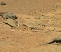
It's been a while since I've noticed any bright fragments like this:
http://mars.jpl.nasa.gov/msl-raw-images/msss/00309/mcam/0309MR1275061000E1_DXXX.jpg
Posted by: fredk Jun 23 2013, 01:58 AM
And I suspect some cloud movement between these sky frames, though hard to be sure with only two frames:
http://mars.jpl.nasa.gov/msl-raw-images/proj/msl/redops/ods/surface/sol/00312/opgs/edr/ncam/NLB_425193246EDR_M0060658NCAM00505M_.JPG
http://mars.jpl.nasa.gov/msl-raw-images/proj/msl/redops/ods/surface/sol/00312/opgs/edr/ncam/NLB_425193155EDR_M0060658NCAM00505M_.JPG
I don't recall any views of clouds from MSL up to now.
Posted by: CosmicRocker Jun 23 2013, 03:47 AM
I now doubt it, after looking at these beds from other points of view, including your latest and one of Phil's recent polar reprojections. It all goes to show just how tricky it can sometimes be to interpret three dimensional geometry from a few snapshots.
Posted by: paraisosdelsistemasolar Jun 23 2013, 04:00 PM
New MastCam Right images are arriving from Sol 311:
http://bit.ly/1a4vUSG
Love that laminations

|
Posted by: Phil Stooke Jun 23 2013, 04:30 PM
Fredk said: "I don't recall any views of clouds from MSL up to now. "
Check out these LPSC goodies:
http://www.lpi.usra.edu/meetings/lpsc2013/eposter/1717.pdf
http://www.lpi.usra.edu/meetings/lpsc2013/pdf/1548.pdf
Phil
Posted by: Phil Stooke Jun 23 2013, 10:53 PM
http://www.midnightplanets.com/web/MSL/image/00313/FLB_425281197EDR_F0060704FHAZ00328M_.html
A drive of a few metres down to a spot near the sol 120 position. If you back at the mastcam pan from that sol reposted just recently by Ant103 (previous page of this thread), we are on the left end of that mosaic.
It looks to me as if the small unlayered rocks littering these scenes have fallen from the rocky bank just above Shaler, which presumably makes them samples of the cratered unit south of Shaler.
Phil
Posted by: Zelenyikot Jun 23 2013, 11:49 PM
Bubble in panorama on Sol 309. Interesting white material inside.
http://mars.jpl.nasa.gov/msl/multimedia/raw/?rawid=0309MR1275063000E2_DXXX&s=309

|
Posted by: serpens Jun 23 2013, 11:58 PM
I don't think that anything is particularly clear where Shaler is concerned. But it seems that there has been a lot of erosion here and the massive sedimentary rocks could well be the remnants of overlying strata. Certainly there seem to be a few examples of contact remnants scattered around implying changes in the sedimentary environment.

|
Posted by: iMPREPREX Jun 24 2013, 12:33 AM
Sols 309:
http://gigapan.com/gigapans/133070
And 311:
http://gigapan.com/gigapans/133071
Posted by: Ant103 Jun 24 2013, 01:32 PM
Sol 313 panoramic
http://www.db-prods.net/marsroversimages/Curiosity/2013/Sol313_pano.jpg
Sol "313". I bet this is a Donald Duck sol 
http://goofy313g.free.fr/calisota_online/cars/313rosa.jpg
Posted by: James Sorenson Jun 24 2013, 02:18 PM
Great one Damia . Takes me back to when Spirit was on the side of Homeplate investigating that bombsag.
Posted by: Phil Stooke Jun 24 2013, 05:01 PM
Yes, it does look a bit like that!
This is a circular version of Damia's pan.
Phil

|
Posted by: EdTruthan Jun 24 2013, 11:06 PM
Sol 314 - Front Hazcam Anaglyph. Nice set of tracks in the foreground... really helps offer some scale to the nearby outcrops.
http://www.edtruthan.com/mars/Sol314-Front-Hazcam-Anaglyph.jpg
Posted by: vikingmars Jun 25 2013, 06:22 PM
Quelle belle image ! Merci Damia !
Posted by: Astro0 Jun 26 2013, 03:36 AM

MSL sunset sol312
Images taken over 5 minutes.
(thumbnails x3 resize)
Posted by: James Sorenson Jun 26 2013, 12:05 PM
Here is the current progress on the Shaler ML Pan. This is just a low res preview, work in progress.
http://www.flickr.com/photos/43581439@N08/9143475018/
Posted by: iMPREPREX Jun 27 2013, 03:16 AM
Nice, James. This is going to be awesome.
Sol 315 - MastCam 100 and Anaglyph:
http://gigapan.com/gigapans/133323
|
Posted by: eoincampbell Jun 27 2013, 03:39 AM
Great view...I believe it includes those peculiar tilted slabs that resemble a tourist-trail-info-table...
from sol 120 : http://www.midnightplanets.com/web/MSL/image/00120/0120ML0752013000E1_DXXX.html
Posted by: xflare Jun 27 2013, 07:03 AM
Some bright stuff on this rock
http://www.midnightplanets.com/web/MSL/image/00315/0315MR1290007000E1_DXXX.html
Posted by: Actionman Jun 27 2013, 12:12 PM
Perhaps non-indigenousness.
Posted by: nprev Jun 27 2013, 12:44 PM
A little darker than the others as well. Been there awhile, too, based on the calved-off frags around it. REALLY old iron-nickel meteorite?
Posted by: Bill Harris Jun 27 2013, 02:17 PM
Could be. And I think I see remnant remaglypts.
--Bill
Posted by: EdTruthan Jun 27 2013, 04:53 PM
Great views everyone... Here's my take on a full resolution (7001x3209 pixels) anaglyph version of the first of the three MC panos shot on Sol 315. This one, at 18 frames, appears to be first sequence completely downloaded thus far from that Sol. Not sure they'll overlap the others yet. http://www.edtruthan.com/mars/Sol315-18-Frame-MC100-Panorama.jpg.
http://www.edtruthan.com/mars/Sol315-18-Frame-MC-Panorama-Anaglyph.jpg
Will post more as completed sets from the many MC pano's taken this week trickle in. Many are are only partially complete (waiting...waiting...aaaarg) but they all look pretty interesting, especially for anaglyph renders. Shaler rocks.
Posted by: Greenish Jun 27 2013, 09:29 PM
Nice focus series of ChemCam shots on Sol 316. Here is a quick focus stack (full size) using the Extended DOF plugin for ImageJ, and a gif (25% size).

|

|
Posted by: Zelenyikot Jun 27 2013, 10:32 PM
I think it's not alone
http://mars.jpl.nasa.gov/msl-raw-images/msss/00109/mcam/0109MR0684007000E1_DXXX.jpg
Posted by: Phil Stooke Jun 28 2013, 12:54 AM
We just had a short drive to reach a different bit of the outcrop.
Phil
Posted by: iMPREPREX Jun 28 2013, 11:35 AM
Here's a mosaic using 3 Chemcam images (from sol 317) - level tweaked, sharpened, and false color added:
http://i.imgbox.com/addjrgiy.jpg
Posted by: iMPREPREX Jun 29 2013, 01:56 AM
And here is Sol 317 (NavCam) colorized (I think I got carried away) and sharpened:
http://www.flickr.com/photos/84750994@N05/9160175660/sizes/k/
And another 317 colorized and sharpened ChemCam mosaic:
http://www.flickr.com/photos/84750994@N05/9156920197/sizes/l/in/set-72157634374415402/
|
|
Posted by: EdTruthan Jun 29 2013, 07:01 PM
Kudos to the imaging team for that saavy moonrise capture! And sweet animation Zelenyikot. Nicely done.
Hitching a ride with MSL, here's a 10 Frame Animated GIF from the front hazcams of the short drive on Sol 317 at 1.4 seconds per frame. The early morning shot is the beginning of the animation:
http://www.edtruthan.com/mars/Sol317-Front-Haz-Short-Drive-Animation-2-D.gif
...and an anaglyph version:
http://www.edtruthan.com/mars/Sol317-Front-Haz-Short-Drive-Animation-Anaglyph.gif
Posted by: James Sorenson Jun 30 2013, 08:16 AM
I agree with Doug.
Here is another Low resolution preview on the current progress of the Sol-313-316 M34 Panorama of Shaler. I'll upload the full resolution when all the images are down.
http://www.flickr.com/photos/43581439@N08/9171054545/
Posted by: Zelenyikot Jun 30 2013, 08:47 AM
Thanks.
Two views of one rock. Sol 120 and 309
|
Posted by: vikingmars Jun 30 2013, 02:38 PM
A colourization try of Sol 312 Right NavCam sunset picture... Enjoy !
|
Posted by: EdTruthan Jul 1 2013, 02:19 AM
Final anaglyph renders of the Sol 303 and Sol 306 mosaics of the big rock at Point Lake in different lighting. The lighting in the Sol 306 image really shows the variety and depth of the hollows and there's one very spiky pinnicle-like remnant that's quite visible in stereo.
(These are massive enough in pixel size browsers cough at them so I zipped the full-resolution versions for download.)
Sol 303 - Click thumb for half-resolution version at 4642 x 3208 px - 3.4MB:
http://www.edtruthan.com/mars/Sol303-MC34-MC100-Point-Lake-Anaglyph-4642x3208px.jpg
~ Full Resolution Anaglyph version is here: http://www.edtruthan.com/mars/Sol303-MC34-MC100-Point-Lake-Anaglyph-9283x6415px.zip (10.02MB)
~ Full Resolution 2-D version is here: http://www.edtruthan.com/mars/Sol303-MC100-Point-Lake-9283x6415px.zip (8.5MB)
Sol 306 - Click thumb for half-resolution version at 4566 x 2817 px - 3.2MB:
http://www.edtruthan.com/mars/Sol306-MC34-MC100-Point-Lake-Anaglyph-4566x2817px.jpg
~ Full Resolution Anaglyph version is here: http://www.edtruthan.com/mars/Sol306-MC34-MC100-Point-Lake-Anaglyph-9132x5633px.zip (9.77MB)
~ Full Resolution 2-D version is here: http://www.edtruthan.com/mars/Sol306-MC100-Point-Lake-9132x5633px.zip (8.5MB)
A copious number of mosaics from this last week just keep pouring in. Keeping track of what's arrived and how their arranged is a bit of a challenge. Some have all the MC34's in but I'll probably wait to collect the corresponding MC 100's for them before rendering them. There's a ton of amazing Shaler panoramas to stitch when the sets are complete. Will post when they're in. Exciting times!
Posted by: iMPREPREX Jul 1 2013, 06:31 PM
Great stuff, everyone.
Here are 2 mosaics from Sol 319 - colorized ChemCam (not false color like I said before- sorry about that):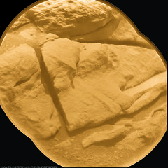
http://www.flickr.com/photos/84750994@N05/9186167766/sizes/l/
and:
http://www.flickr.com/photos/84750994@N05/9184307979/sizes/l/
Posted by: Zelenyikot Jul 1 2013, 08:37 PM
My try
|
Posted by: PaulH51 Jul 1 2013, 09:37 PM
A short but interesting report:-
Sol 322 Update on Curiosity from USGS Scientist Ken Herkenhoff: 'Contacting Shaler' (dated: 1 July 2013)
http://astrogeology.usgs.gov/news?id=news/sol-322-update-on-curiosity-from-usgs-scientist-ken-herkenhoff-contacting-shaler
Posted by: centsworth_II Jul 1 2013, 11:55 PM
According to http://www2.le.ac.uk/departments/physics/research/src/res/planetary-science/mslblog/john-bridges-mars-science-laboratory-blog?b_start:int=0 July 1st entry, "This weekend a group of us... went on a field trip to sample areas in the southwest UK - mudstones with sulphate veining - that we are studying in parallel with the MSL research."
Maybe they were headed to the area discussed in this paper:
http://academia.edu/897409/Gypsum_veins_as_hydrofrac-tures_in_layered_and_faulted_mudstones_implications_for_reservoir_permeability_Poster
The mudstone matrix is even the right color!

|
"Here we present field measurements of mineral veins in coastal sections near the village of Watchet on the Somerset Coast of Southwest England."
Posted by: Phil Stooke Jul 2 2013, 05:17 PM
http://www.midnightplanets.com/web/MSL/image/00308/0308MR1273008000E1_DXXX.html
Looks like one of those bubble things seen earlier.
Phil
Posted by: fredk Jul 2 2013, 06:02 PM
In stereo:
|
|
Posted by: mhoward Jul 2 2013, 07:02 PM
Wow! That's a nice bubble. That was on the way back to Shaler; actually it's the same general area where she saw several bubbles on the way into Yellowknife Bay.
Shaler is to the SW in this view and the bubble is in the white box:
|
Posted by: EdTruthan Jul 3 2013, 06:49 PM
Dusk & Twilight... Sol 322...
http://www.edtruthan.com/mars/Sol322-Navcam-Working-At-Dusk-Anaglyph.jpg
http://www.edtruthan.com/mars/Sol322-Navcam-Working-At-Twilight-Anaglyph.jpg
Posted by: Phil Stooke Jul 3 2013, 11:55 PM
http://astrogeology.usgs.gov/news?id=news/sol-324-update-on-curiosity-from-usgs-scientist-ken-herkenhoff-finishing-up-at-shaler
Finishing up! - and a drive planned for sol 324. Perhaps this is ambiguous - is that drive the 'finishing up' or the start of the long drive? Regardless, it's a drive so I can map it
Phil
Posted by: atomoid Jul 4 2013, 07:30 AM
http://www.midnightplanets.com/web/MSL/image/00323/0323MH0302001000C0_DXXX.html http://www.midnightplanets.com/web/MSL/image/00323/0323MH0190001000C0_DXXX.html http://www.midnightplanets.com/web/MSL/image/00323/NLB_426161627EDR_S0060804NCAM00542M_.html-http://www.midnightplanets.com/web/MSL/image/00323/CR0_426168169EDR_F0060804CCAM01323M_.html-http://www.midnightplanets.com/web/MSL/image/00323/CR0_426168316EDR_F0060804CCAM01323M_.html http://www.midnightplanets.com/web/MSL/image/00323/FRB_426165006EDR_F0060804FHAZ00206M_.html-http://www.midnightplanets.com/web/MSL/image/00323/NRB_426165059EDR_F0060804NCAM00207M_.html http://www.midnightplanets.com/web/MSL/image/00317/0317ML1300020000E1_DXXX.html

|
Posted by: Bill Harris Jul 4 2013, 11:40 AM
--Bill
Posted by: Zelenyikot Jul 4 2013, 07:02 PM
Sky in MAHLI.
I think they try to catch clouds in focus.
|
Posted by: SFJCody Jul 4 2013, 07:12 PM
The textures of the rocks around here kind of remind me of some that Spirit saw in the Columbia Hills.
Posted by: James Sorenson Jul 4 2013, 07:44 PM
I think they try to catch clouds in focus.
I think those are MAHLI Sky Flats. Done for calibration purposes.
Posted by: Zelenyikot Jul 4 2013, 08:03 PM
I dream about clouds

Colored ChemCam on Sol 323
|
Posted by: Phil Stooke Jul 4 2013, 09:10 PM
And I dream about great pics like that one!
Phil
Posted by: EdTruthan Jul 5 2013, 08:07 AM
Is that Willie Nelson I hear? Sol 324 - 17.96 meter drive over old Sol 120 tracks back towards Bell Island. Looks like she drove stern first, and in less than 9 minutes to boot - that's really cookin'...
Shaler out the rear view mirror (front hazcams)...
http://www.edtruthan.com/mars/Sol324-Leaving-Shaler-Front-Haz-(Astern)-Anaglyph.jpg
Over Sol 120 tracks looking dead ahead toward Bell Island (rear hazcams).
http://www.edtruthan.com/mars/Sol324-Leaving-Shaler-Rear-Haz-(In_Front)-Anaglyph.jpg
It's been half a year for those old tracks now. Interesting to see them again. To my eye they do look a bit softened up and drifted into...
Posted by: Ant103 Jul 5 2013, 12:04 PM
|
|
This is GREAT !!!
Awesome colorization you've made here (Finally a sunset picture, after 11 earth month, this was long ).Sorry for all if I didn't produced anything, I was not home, but at a friend's home (at Dijon), and at Paris (the Pride Walk), so I didn't have the time (and the mood), to process some panoramics
. I will take back to my late in the next few days I think.
Posted by: Phil Stooke Jul 5 2013, 01:37 PM
A rough circular pan of three Navcams from the current location. The tracks at upper left are from sol 55 on the drive to Rocknest, which is just off the top of this image.
Phil

|
Posted by: EdTruthan Jul 5 2013, 06:35 PM
And finally in... a much closer look at one the bubbles - Sol 308:
http://www.edtruthan.com/mars/Sol308-MC34-MC100-The-Bubble.jpg
...and an anaglyph:
http://www.edtruthan.com/mars/Sol308-MC34-MC100-The-Bubble-Anaglyph.jpg
My my...
Posted by: fredk Jul 5 2013, 08:39 PM
And a nice comparison between fresh tracks and some a couple hundred sols old:
http://mars.jpl.nasa.gov/msl-raw-images/proj/msl/redops/ods/surface/sol/00324/opgs/edr/ncam/NLB_426264450EDR_F0070000NCAM05133M_.JPG
Posted by: Zelenyikot Jul 5 2013, 10:14 PM
Little veins in Shaler on Sol 322

|
Posted by: mhoward Jul 6 2013, 04:47 PM
I've started the new topic for http://www.unmannedspaceflight.com/index.php?showtopic=7691 and moved SFJCody's post there.
Posts about Cumberland and the second visit to Point Lake and Shaler continue to belong in this thread. Check the topic descriptions for exact dates, sols and sites.
Posted by: Airbag Jul 6 2013, 05:31 PM
The Sol 323 MRs down so far form a roughly 90 degrees wide pan http://curiosityrover.com/imgpoint.php?name=0317ML1300012000E1_DXXX, towards the dune fields:
|
|
Some full size details:
|
|

|
Airbag
Posted by: Phil Stooke Jul 7 2013, 12:38 AM
This bit (contrast bumped up a bit) looks like it has some big fat veins just waiting to be looked at.
Phil

|
Posted by: CosmicRocker Jul 7 2013, 05:17 AM
They're amazing. It's interesting to see the ubiquitous veinwork of Mars at so many different scales.
Posted by: Zelenyikot Jul 7 2013, 10:56 AM
"Chevron" on Sol 325.
|
Posted by: Actionman Jul 7 2013, 12:11 PM
Looks more like particle segregation more so then vein concretion being the color is the same as or close to the atmosphere dust.
Posted by: EdTruthan Jul 7 2013, 05:00 PM
Here are half and full resolution versions of the complete 44 frame MC100 2-D panorama from Sol 323:
Click thumbnail for Half Resolution version at 11797 x 1184 pixels (2.78MB):
http://www.edtruthan.com/mars/Sol323-MC100-Panorama-11797x1184px.jpg
Full Resolution version at a whopping 23594 x 2368 pixels (9.38MB) is here: http://www.edtruthan.com/mars/Sol323-MC100-Panorama-23594x2360px.jpg
Posted by: EdTruthan Jul 9 2013, 06:19 PM
Two more recent MC34/MC100 complete sets are now fully downloaded. Here they are in Anaglyph and 2-D versions...
Sol 308 - Approaching Shaler, bubble region. This is the full 60 frame pano in which that well defined bubble appears (lower right center). There are two more distinct bubble remants in the image. One, a half bubble at upper right and the other a full bubble at upper center. In addition (to my eye at least), there appears to be at least two more bubble-like remnant "dishes" in the image. The channel split variance from the angle and size of the area captured makes very close zooming on the upper section a bit tough on the eyes, but zooming out a bit solves the problem.
(Click thumb for half-sized version (5770 x 3850 pixels - 3.22MB):
http://www.edtruthan.com/mars/Sol308-(MC-Set-1273)-60-Frame-Panorama-Anaglyph-5770x3850px.jpg
Full Resolution 11540 x 7700 pixel Anaglyph version is here in a 10.12MB Zip: http://www.edtruthan.com/mars/Sol308-(MC-Set-1273)-60-Frame-Panorama-Anaglyph-11540x7700px.zip
Full Resolution 11540 x 7700 pixel 2-D version is here in a 8.49MB Zip: http://www.edtruthan.com/mars/Sol308-(MC-Set-1273)-60-Frame-Panorama-11540x7700px.zip
Sol 306 - Point Lake surroundings. An 18 frame view with a nice depth of field. Center of the view faces approximately 200 degrees azimuth. Several of the MC100 frames at lower center were a bit out of focus, otherwise a pretty crisp set overall. Same channel split variances for close-zoom issues apply here too.
Click thumb for full-sized version (9755 x 3315 - 4.53MB):
http://www.edtruthan.com/mars/Sol306-(MC-Set-1267)-18-Frame-Panorama-Anaglyph.jpg
Full resolution 2-D version is here: http://www.edtruthan.com/mars/Sol306-(MC-Set-1267)-18-Frame-Panorama.jpg
Posted by: blake Jul 10 2013, 01:35 PM
The linked gif shows a sequence of arm movements from sols 322-324. The ambient background lighting is interesting over the duration.
http://blakefallconroy.com/UMSF/322-324arm-movements1.gif
Posted by: blake Jul 10 2013, 02:01 PM
Also, attached is a stitched image of some sol 322 MAHLI captures in context to one another (and annotated, hopefully, in a way that makes sense).
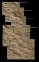
|
Posted by: fredk Jul 10 2013, 03:38 PM
From back at sol311, this has got to be the craziest thin erosion feature we've seen, in anaglyph and side-by-side:

|

|
Posted by: atomoid Jul 10 2013, 06:05 PM
crazy indeed! It takes a good eye, thanks for catching that!.. this one makes that jutting http://www.midnightplanets.com/web/MSL/image/00173/0173MR0926020000E1_DXXX.html seemingly dull by comparison, or i guess i would rephrase that since the specular glint on Italy is actually relatively brilliant and this new one being more 'fantastical' in scope...
i like this other little formation on 311 as well, tried using http://stereo.jpn.org/eng/stphmkr/.. its difficult using the m-100/m-34 pairs with their different sizes and aspects..
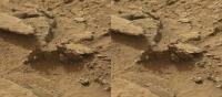
|
Posted by: James Sorenson Jul 10 2013, 06:08 PM
Agreed! Looks like a Marlin Jumping out of water!
Posted by: fredk Jul 10 2013, 07:16 PM
That is a nice one, too. And there's a bright fragment there, which you can see more clearly in this view:
http://mars.jpl.nasa.gov/msl-raw-images/msss/00309/mcam/0309MR1276000000E1_DXXX.jpg
Posted by: phase4 Jul 10 2013, 11:33 PM
Wow, did Curiosity break down this big rock at sol 313??
I hope this won't turn into an interplanetary lawsuit
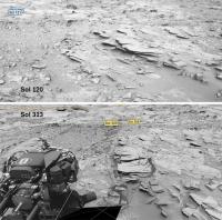
|
Posted by: atomoid Jul 11 2013, 05:48 PM
I hope this won't turn into an interplanetary lawsuit…
The defense might posit http://www.midnightplanets.com/web/MSL/image/00313/0313MR1286011000E1_DXXX.html, that said edge was already broken long before, with Curiosity only merely tipping the edge out from under cover of sand by inadventently stepping or bumping it.
 The defense rests, considering counter-suit of public nuisance hazard, no damages claimed..
Posted by: EdTruthan Jul 11 2013, 07:53 PM
Two more complete MC34/MC100 sets from the Shaler visit are in. Here are Anaglyph and 2D versions of both...
Sol 309 - North side of Shaler. A 60 frame mosaic with lots of interesting geology. There's a hollowed out bubble remnant at extreme lower left. The depth of field makes close zooms on the upper right and lower left a bit testy but I've tried to balance the channel separation overall for easy viewing. Click thumb for half sized version (6776 x 4064 pixels - 5.18MB):
http://www.edtruthan.com/mars/Sol309-MC34-MC100-(Set-1275)-North-Shaler-Anaglyph-6776x4064px.jpg
Full resolution Anaglyph version (13551 x 8128 pixels) is here in a 16.64MB Zip: http://www.edtruthan.com/mars/Sol309-MC34-MC100-(Set-1275)-North-Shaler-Anaglyph-13551x8128px.zip
Full resolution 2D version (13551 x 8128 pixels) is here in a 14.71MB Zip: http://www.edtruthan.com/mars/Sol309-MC100-(Set-1275)-North-Shaler-2D-13551x8128.zip
Sol 311 - North side of Shaler. A 44 frame mosaic. The details brought out by the low sun angle makes this one a real treat. The spiked remnant pointed out in http://www.unmannedspaceflight.com/index.php?s=&showtopic=7659&view=findpost&p=201522 is near the left center of the mosaic. Same channel separation extremes begin to arise at upper left and lower right. Click thumb for half sized version (7538 x 4426 pixels - 5.65MB):
http://www.edtruthan.com/mars/Sol311-MC34-MC100-(Set-1279)-North-Shaler-Anaglyph-7538x4426.jpg
Full resolution Anaglyph version (15076 x 8851 pixels) is here in a 15.65MB Zip: http://www.edtruthan.com/mars/Sol311-MC34-MC100-(Set-1279)-North-Shaler-Anaglyph-15076x8851px.zip
Full resolution 2D version (15076 x 8851 pixels) is here in a 13.06MB Zip: http://www.edtruthan.com/mars/Sol311-MC100-(Set-1279)-North-Shaler-2D-15076x8851px.zip
Posted by: Phil Stooke Jul 16 2013, 12:31 AM
Looks like quite a trip ahead of us! (actually it's behind us but you know what I mean - a rugged landscape)
http://www.midnightplanets.com/web/MSL/image/00312/0312MR1280006000E1_DXXX.html
Phil
Posted by: mhoward Jul 16 2013, 12:49 AM
That same mosaic has a really lovely view of "Rocknest". I've kind of gotten exhausted saying "wow" at every new sight, but - wow.

|
Posted by: Gerald Jul 25 2013, 01:19 PM
A Sol 317 3x8 images Mastcam Left mosaic:
http://imgbox.com/acfqmJyi
(9089x3290 pixel, 9.523 kB)
Still interesting, the variability of layers within a small location.
Posted by: iMPREPREX Jul 27 2013, 11:32 AM
We just got the down-link to perhaps the last of the MastCam images from 315 and 316 (for the Shaler mosaic) as well as some from 317 and 318. Here's a quick anaglyph before I go to sleep from 318:
http://www.flickr.com/photos/84750994@N05/9377385196/sizes/o/
Posted by: Zelenyikot Jul 27 2013, 12:05 PM
Rock on Sol 316

|
Posted by: iMPREPREX Jul 28 2013, 12:45 AM
Awesomeness from sol 317. Sequence #1300:
Full size: http://www.flickr.com/photos/84750994@N05/9381670728/sizes/o/
GigaPan: http://www.gigapan.com/gigapans/135792
Sequence #1299 (both MastCam 100 and anaglyph) - masked, dust removed, and sharpened:
Full size: http://www.flickr.com/photos/84750994@N05/9379317451/sizes/o/
GigaPan: http://www.gigapan.com/gigapans/135794
Posted by: iMPREPREX Jul 28 2013, 12:10 PM
Regarding the 313-316 Shaler mosaic, there are obviously some images that are out of focus. Some were re-shot on 316, but not all have been down-linked yet. I've made a list of what re-shoots we have corresponding with the blurry ones. I thought I would share what I have so far:
Blurry: Sol 313, Sequence 1286, Images 134 - 136
Re-shot: Sol 316, #1296, Images 0 - 2
Blurry: Sol 314, #1287, Images 76 - 83
Re-shot: Sol 316, #1296, Images 3 - 10
And that's all I have for now. I don't know about the other 15 yet.
Posted by: Gerald Jul 28 2013, 03:00 PM
Don't look at http://makeagif.com/hPcx7r for too long, if you tend to become see-sick. Shadows move, perspective changes slightly.
Posted by: Airbag Jul 29 2013, 02:28 AM
Coverage so far for the Shaler sols 313-316 and 317-323 image sets seen in 360 degree equirectangular projections. Looks like we might expect another couple of rows for the 313-316 set and some scattered images for the 317-323 set (ignoring focus issues).

|

|
Airbag
Posted by: iMPREPREX Jul 29 2013, 09:55 AM
It seems I've figured out how to align these anaglyphs A LOT better than I have been. The result is twentyfold.
My take on 311's anaglyph that I forgot about () with the MastCam 100 version I never finished:
GigaPan: http://gigapan.com/gigapans/135936
Full sized image: http://www.flickr.com/photos/84750994@N05/9396681740/sizes/o/
Wow!
(Edited to add the dual mosaic)
Posted by: iMPREPREX Jul 30 2013, 07:10 PM
Still trying to get these right. As per Ed Truthan's advice, I'm trying to get the offset of the X and Y axis around the focal point correct. It may take a few tries, but I'll get there. Thanks again for helping me out, Ed.
My takes on 308 - MastCam 100 with anaglyph:
GigaPan: http://www.gigapan.com/gigapans/136013
Full sized image: http://www.flickr.com/photos/84750994@N05/9403888004/sizes/o/
Posted by: iMPREPREX Jul 30 2013, 11:10 PM
I think I may have done a better job on this one. And I masked out the rover equipment on the bottom left. My take:
Sol 309 - MastCam 100 with Anaglyph. 
Full sized image: http://www.flickr.com/photos/84750994@N05/9402428711/sizes/o/
GigaPan: http://gigapan.com/gigapans/136027
Posted by: iMPREPREX Aug 1 2013, 09:32 AM
And I got it. I tested it out on 298, which I also forgot to do when it came out.
Here's a trifecta of mosaics. 
Full sized image: http://www.flickr.com/photos/84750994@N05/9412357033/sizes/o/
GigaPan: http://www.gigapan.com/gigapans/136266
Posted by: EdTruthan Aug 1 2013, 06:31 PM
Sol 323 Dune Field View Anaglyph - A very nice stereo view of the dune field, pairing the 18 newly arrived MC 34 frames with their MC 100 counterparts, comprising most of the upper section of a 2 row 44 frame pano. Mostly not the direction we're heading now of course, but one of the nicest contiguous stereo views of this area thus far...
Anaglyph at 21,277 x 1400 pixels:
http://www.edtruthan.com/mars/Sol323-MC34-MC100-Dune-Field-Panorama-Upper-Section-Anaglyph.jpg
MC 100 2-D - 23,594 x 2368 pixels:
http://www.edtruthan.com/mars/Sol323-MC100-Dune-Field-Panorama.jpg
FYI Note: Major internet outages with right now with Endurance International Group (includes Bluehost my hosting company), so thumbnails from all my posts and downloadable files may be intermittent till they're back up. Millions of people are affected. Grrrr.
Posted by: Astro0 Aug 23 2013, 07:10 AM
A little image sequence from Sol319 in panorama.
|
|
Posted by: James Sorenson Aug 26 2013, 03:31 PM
A 3D stereo Reconstruction of some MAHLI images while we were at point lake. In the description is the raw image frames used, and a 3D Anaglyph.
http://www.youtube.com/watch?v=1Cve-OKbkkU
Posted by: djellison Aug 26 2013, 04:02 PM
Oh interesting - great stuff! I thought I was going to see an animation of the depth-map that MAHLI sometimes makes. What software did you use for mesh generation?
Posted by: James Sorenson Aug 26 2013, 04:21 PM
Right now the trial version of Photomodeler scanner, but I'm saving up for the full version. Its an over 2,500 dollar program that I'll be using also for other personal projects.
Posted by: CosmicRocker Aug 27 2013, 03:54 AM
Very cool stuff. Pricey, but very cool.
I really must try that demo. :-)
Powered by Invision Power Board (http://www.invisionboard.com)
© Invision Power Services (http://www.invisionpower.com)