Titan's Equatorial Sand Seas |

  |
Titan's Equatorial Sand Seas |
 Jan 11 2009, 04:31 AM Jan 11 2009, 04:31 AM
Post
#376
|
||
 Senior Member  Group: Moderator Posts: 2785 Joined: 10-November 06 From: Pasadena, CA Member No.: 1345 |
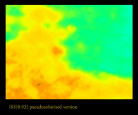
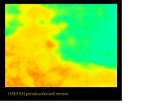
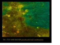
Here is a pseudocolorized blink of the same region:
(click to animate) The animation starts with the pseudocolorized image, then goes to the pseudocolorized T8-T41 combo overlay, then to the T8-T41 RADAR combo, then stepwise back again. That bright blob in the center is the one discussed in the above post. -Mike -------------------- Some higher resolution images available at my photostream: http://www.flickr.com/photos/31678681@N07/
|
|
 |
 
|
|
|
Jan 11 2009, 05:02 AM
Post
#377
|
||||||
|
Senior Member Group: Moderator Posts: 2785 Joined: 10-November 06 From: Pasadena, CA Member No.: 1345 |
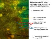
Here's a graphic annotating the RADAR-dark ISS-bright flow-like feature near the Flower Petal Crater:
And here are the individual JPEGS from the blink animations above - coordinated and sized up. Download, cut/copy/paste into Powerpoint and control your own blink animation!!
A full-resolution version of the pseudocorolized Flower Crater image can be downloaded here: http://www.flickr.com/photos/31678681@N07/3186209887/ Enjoy! -Mike -------------------- Some higher resolution images available at my photostream: http://www.flickr.com/photos/31678681@N07/
|
|||||
|
|
|
|||||
|
Jan 12 2009, 07:24 PM
Post
#378
|
|
|
Rover Driver Group: Members Posts: 1015 Joined: 4-March 04 Member No.: 47 |
Yet another beauty! And possibly quite insightful. Keep up the good work

|
|
|
|
|
Jan 15 2009, 02:12 AM
Post
#379
|
||
|
Senior Member Group: Moderator Posts: 2785 Joined: 10-November 06 From: Pasadena, CA Member No.: 1345 |
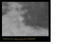
Pseudocolorized East Adiri Archipelago.:
Huygens Landing site is just right of the center of the image. Full resolution (at 256 pixel/degree or theoretical 170 m/pixel) available here -Mike -------------------- Some higher resolution images available at my photostream: http://www.flickr.com/photos/31678681@N07/
|
|
|
|
|
|
|
Jan 16 2009, 01:27 PM
Post
#380
|
||
|
Senior Member Group: Moderator Posts: 2785 Joined: 10-November 06 From: Pasadena, CA Member No.: 1345 |
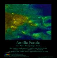
Pseudocolorized graphic of Antilla Facula (zoom of the East Adiri Archipelago).
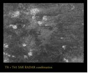
T8+T41 SAR RADAR Swaths overlaid on a pseudocolorized ISS basemap from PIA08399
The Huygens Landing site is at the center of the image. Full resolution in color (at 256 pixel/degree or theoretical 170 m/pixel) available here. Full resolution in black and white (at 256 pixel/degree or theoretical 170 m/pixel) available here. -Mike -------------------- Some higher resolution images available at my photostream: http://www.flickr.com/photos/31678681@N07/
|
|
|
|
|
|
|
Feb 27 2009, 02:51 PM
Post
#381
|
|
 Newbie Group: Members Posts: 9 Joined: 30-November 07 Member No.: 3972 |
*
|
|
|
|
|
Feb 27 2009, 04:19 PM
Post
#382
|
|
|
Senior Member Group: Members Posts: 3516 Joined: 4-November 05 From: North Wales Member No.: 542 |
QUOTE (Adzel @ Feb 27 2009, 02:51 PM)  I hope this is okay to post here Very much so. Only the first of those figures appears in the news release on the Cassini website. But there they also have a rather nice SAR dunes image which I don't think has appeared before. http://saturn.jpl.nasa.gov/photos/imagedet...fm?imageId=3430 http://saturn.jpl.nasa.gov/photos/imagedet...fm?imageId=3431 |
|
|
|
|
Feb 27 2009, 04:51 PM
Post
#383
|
|
|
Newbie Group: Members Posts: 9 Joined: 30-November 07 Member No.: 3972 |
*
|
|
|
|
|
Feb 27 2009, 06:06 PM
Post
#384
|
|
|
Senior Member Group: Members Posts: 3516 Joined: 4-November 05 From: North Wales Member No.: 542 |
I have one comment and one (very basic) question.
On the correlation of dune azimuth with latitude - I think a higher correlation coefficient might be obtained by restricting the analysis to the latitude range 15-30 degrees N and S. To even a casual glance the global map of Titan (especially the nice new one) reveals a strong westward-pointing-chevron-like trend in the albedo features in those latitude ranges. Indeed the scatter in the graph above does seem to get 'fatter' nearer the equator. The question - when looking at longitudinal dunes that align with the wind direction how do you tell which is the upwind end? It must be possible since the authors firmly conclude that the wind blows the opposite way to that predicted by climate models. The simple statement that the dunes act as weathervanes leaves me unsatisfied. I can see the shaft of the weathervane but not the arrow on the end! |
|
|
|
|
Feb 27 2009, 06:30 PM
Post
#385
|
|
|
Newbie Group: Members Posts: 9 Joined: 30-November 07 Member No.: 3972 |
*
|
|
|
|
|
Feb 27 2009, 08:03 PM
Post
#386
|
|
|
Senior Member Group: Members Posts: 3516 Joined: 4-November 05 From: North Wales Member No.: 542 |
So the direction is observed at margins and near obstacles and extrapolated from there out into the wider dunefields? That makes perfect sense.
From the press release I got the impression that the wind direction had been uniquely and independently determined (without 180 degree ambiguity) at all the sample points. Therefore I was wondering how this could be done, say, in the middle of Belet. Maybe it wasn't, in which case the question goes away. |
|
|
|
|
Feb 27 2009, 08:41 PM
Post
#387
|
|
|
Newbie Group: Members Posts: 9 Joined: 30-November 07 Member No.: 3972 |
*
|
|
|
|
|
Feb 27 2009, 09:08 PM
Post
#388
|
|
|
Senior Member Group: Moderator Posts: 2785 Joined: 10-November 06 From: Pasadena, CA Member No.: 1345 |
An important consideration is that the dune seas themselves are not necessarily flat.
(The T8 altimetry swath north of the Huygens Landing Site in T8 shows a significant drop downwards as one tracks further into Shangri-La basin.) (Check out: Post 251, this thread) Some of the twists and curves of the dune seas may be due to topographic features inside the basins that are not obvious when looking at RADAR interdune patterns. (Example here: Post 11, Titan Dunes thread) (No offense to VP, but I don't think ISS gives much additional differentiation inside the dark basins). -Mike -------------------- Some higher resolution images available at my photostream: http://www.flickr.com/photos/31678681@N07/
|
|
|
|
|
Feb 27 2009, 10:15 PM
Post
#389
|
|
 Senior Member Group: Moderator Posts: 3233 Joined: 11-February 04 From: Tucson, AZ Member No.: 23 |
Are you sure the positioning for that SARTopo is correct? Most altimetry swaths of the sedimentary basins on Titan show the dune fields to be quite flat with modulation due to the dunes.
QUOTE No offense to VP, but I don't think ISS gives much additional differentiation inside the dark basins We do know there are albedo variations within the dune fields, likely due to differences in albedo of the substrate. We've seen this in Shangri-la and Fensal, definitely.
-------------------- &@^^!% Jim! I'm a geologist, not a physicist!
The Gish Bar Times - A Blog all about Jupiter's Moon Io |
|
|
|
|
Feb 28 2009, 04:24 AM
Post
#390
|
|
|
Senior Member Group: Moderator Posts: 2785 Joined: 10-November 06 From: Pasadena, CA Member No.: 1345 |
QUOTE (volcanopele @ Feb 27 2009, 05:15 PM) Are you sure the positioning for that SARTopo is correct? Most altimetry swaths of the sedimentary basins on Titan show the dune fields to be quite flat with modulation due to the dunes The SARTopo was taken right at the upper "stitch zone" in the T8 Swath. (more info here: post 256, this thread) QUOTE (volcanopele @ Feb 27 2009, 05:15 PM) We do know there are albedo variations within the dune fields, likely due to differences in albedo of the substrate. We've seen this in Shangri-la and Fensal, definitely. IIRC, I think VIMS also saw differences in spectral characteristics also (Barnes et al description of T20?). This was attributed to intradune (or is it interdune?) clear zones - the dune material was swept up in dunes leaving a clean floor in between. (Check out: post 277 and onwards, this thread) -Mike -------------------- Some higher resolution images available at my photostream: http://www.flickr.com/photos/31678681@N07/
|
|
|
|
|

|
Lo-Fi Version | Time is now: 27th April 2024 - 06:51 AM |
|
RULES AND GUIDELINES Please read the Forum Rules and Guidelines before posting. IMAGE COPYRIGHT |
OPINIONS AND MODERATION Opinions expressed on UnmannedSpaceflight.com are those of the individual posters and do not necessarily reflect the opinions of UnmannedSpaceflight.com or The Planetary Society. The all-volunteer UnmannedSpaceflight.com moderation team is wholly independent of The Planetary Society. The Planetary Society has no influence over decisions made by the UnmannedSpaceflight.com moderators. |
SUPPORT THE FORUM Unmannedspaceflight.com is funded by the Planetary Society. Please consider supporting our work and many other projects by donating to the Society or becoming a member. |
|