Printable Version of Topic
Click here to view this topic in its original format
Unmanned Spaceflight.com _ MSL _ MSL at Rocknest
Posted by: elakdawalla Oct 3 2012, 12:30 AM
Curiosity has put more than 400 meters on the odometer and tosol (sol 56) she bumped up to a sand drift that we now know (http://twitter.com/MarsCuriosity/statuses/253272908317728768) is named Rocknest and will be the site of the first sample grab. In last week's press briefing, John Grotzinger warned that we will be here for "what seems like a very long time," 2-3 weeks. They will have to run several samples through the SA-SPaH (Sample Acquisition, Processing and Handling subsystem, pronounced "Saw-spa") and in particular CHIMRA (Collection and Handling for In situ Martian Rock Analysis, pronounced "chimera") in order to "clean" it of any remaining Earthly contamination with good Mars dirt before they deliver the first sample to SAM or Chemin. So this seems like a good place to start a new thread.
As usual, discuss stuff that happened through sol 56 in the http://www.unmannedspaceflight.com/index.php?showtopic=7471.
Posted by: belleraphon1 Oct 3 2012, 10:59 AM
Putting this here because assume they will discuss future plans....
NASA HOSTS OCT. 4 TELECONFERENCE ABOUT MARS CURIOSITY ROVER PROGRESS
NASA will host a media teleconference at 11 a.m. PDT (2 p.m. EDT) Thursday, Oct. 4, to provide a status update on the Curiosity rover's mission to Mars' Gale Crater.
http://www.nasa.gov/news/media/newsaudio/index.html
Craig
Posted by: charborob Oct 3 2012, 08:44 PM
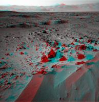
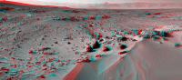
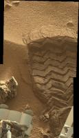
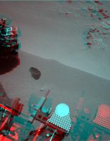
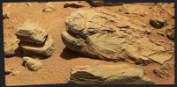
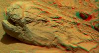
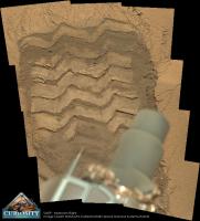
Sol 57 navcam anaglyph:
|
Posted by: ronald Oct 3 2012, 08:47 PM
|
|
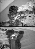
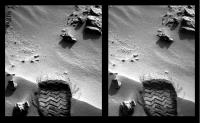
Stomp!

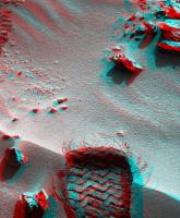
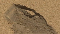
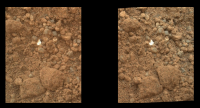
Posted by: renee Oct 3 2012, 09:48 PM
Actually, this says a lot about the plasticity of the surface at Glenelg.
Oops no it doesn't. That's a tire....not a print. But what are the fibers?
Renee
Posted by: ngunn Oct 3 2012, 09:58 PM

We see a lot of wonderful anaglyphs these days, and thanks to all! But this one is particularly good.

Posted by: Ant103 Oct 3 2012, 10:12 PM
Navcam pan of Sol 57. Anaglyp version is fine too .
http://www.db-prods.net/marsroversimages/Curiosity/2012/Sol57_pano.jpg
http://www.db-prods.net/marsroversimages/Curiosity/2012/Sol57_pano_ana.jpg
What a wonerful site !
Posted by: ronald Oct 3 2012, 10:14 PM
Oops no it doesn't. That's a tire....not a print. But what are the fibers?
Renee
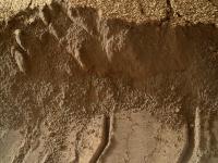
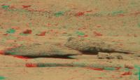
Just looking at the images as an amateur I would suppose that there is coarser material on top of much finer material. And no - its not a tire
and the "fibers" are just cracks or fractions in the "sand".
Posted by: Ant103 Oct 3 2012, 10:26 PM
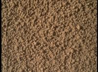
I can recall that the martian soil is acting like a wet sand, but it's actually very dry. The consequence of a material named "maghemite" (imagine a magnet, but in powder, it's pretty much like that). At the surface of this dune, there is a crust, where the sand particles have got some cohesion because of the alternance of wetting and drying. So then, when you walk on it, its like you're walking on snow, with a surface which became hard due to sunlight. And under, you have some wet-but-yet-dry soil.
I hope I was clear 
Posted by: ronald Oct 3 2012, 10:29 PM
The navcam pans are really nice!
I hope it is OK for Ant103 - I did go over his anaglyph and made it a bit brighter (of course this kills the mood a bit):
|
Posted by: Ant103 Oct 3 2012, 11:41 PM
Oh no, that's not a problem. But yes, with jpeg compression and brightening, the stereoscopic effect is reduced.
PS : Panos updated.
Posted by: renee Oct 4 2012, 12:12 AM
"Just looking at the images as an amateur I would suppose that there is coarser material on top of much finer material. And no - its not a tire and the "fibers" are just cracks or fractions in the "sand"."
Thar being the case, isn't the'surface" pretty unexpected?
Renee
Posted by: Reed Oct 4 2012, 12:57 AM
To me, it looks very similar to what was seen when the MERs drove into ripples. A slightly crusty surface is expected.
Posted by: djellison Oct 4 2012, 01:14 AM
Look identical to similar exercises at Gusev and Meridiani.
Posted by: centsworth_II Oct 4 2012, 02:24 AM
For comparison, here is from Spirit on sols 72 and 74.
|
Posted by: renee Oct 4 2012, 05:27 AM
Actually, now that I see it, you're right. I just was not expecting that sub-surface. I was expecting more sand.
Renee
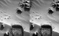
Posted by: udolein Oct 4 2012, 01:57 PM
Wheel digging at rocknest on Sol 57:
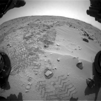
|
http://www.marspages.eu/media/archive4/science_laboratory/14rocknest/Sol57_DuneMovie2.gif
seen from the HazCam
Cheers, Udo
Posted by: udolein Oct 4 2012, 02:00 PM
... and from the MastCam:

|
http://www.marspages.eu/media/archive4/science_laboratory/14rocknest/Sol57_DuneMovie.gif
Udo
Posted by: stewjack Oct 4 2012, 05:51 PM
I hope it is OK for Ant103 - I did go over his anaglyph and made it a bit brighter (of course this kills the mood a bit):
Are we looking approx. North? I think I can see the northern inlet channel, in the crater wall - in the center of the anaglyph! If so - that is sharp and bright!
http://www.unmannedspaceflight.com/index.php?act=attach&type=post&id=28432
And I was ( once again ) poorly oriented.
News Conference Starting
Posted by: Doc Oct 4 2012, 06:26 PM
8gs! I guess Phoenix's poor performance during sample drop off really put them off at the time! (Drop that load properly you lousy piece of hardware! )
Posted by: Eyesonmars Oct 4 2012, 07:15 PM
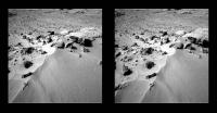
|
|
Stomp!
great cross eyed image
The slight slumping and cracking around the wheel marks seem to imply some sort of lightly cemented crust. So these little drifts are probably not active. ( I see that this has been discussed. But could all these drifts the mers and curiosity have treaded be inactive because they are crusted?)
Posted by: elakdawalla Oct 4 2012, 09:07 PM
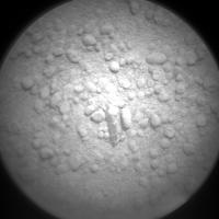
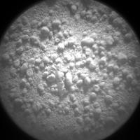
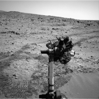
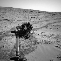
Sol 58 images coming down now. I like this one: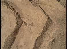
https://planetary.s3.amazonaws.com/assets/images/4-mars/2012/20121004_0058MH0023001000E1_DXXX.jpg
Posted by: udolein Oct 4 2012, 09:49 PM
Animation of arm movement between 1 pm and 3 pm local time:
|
http://www.marspages.eu/media/archive4/science_laboratory/14rocknest/Sol58_MAHLI_Animation.gif
the animation begins with the APXS measurement at 1 pm. The instrument changes to MAHLI followed by undisturbed and wheel disturbed soil region images respectively.
Undisturbed soil image:
|
Cheers, Udo
Posted by: brellis Oct 4 2012, 10:11 PM
Re: Emily's post #466 pic - that really looks like it was wet not so long ago.
Posted by: elakdawalla Oct 4 2012, 10:18 PM
To me it looks exactly like flour. Completely dry, yet cohesive -- that's the nature of very fine-grained material.
Posted by: ronald Oct 4 2012, 10:26 PM
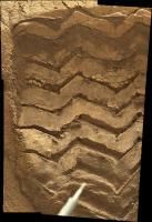
Really nice MAHLI images coming in - SOL 58:
|
I would http://www.nasa.gov/centers/dryden/images/content/673116main_ED12-0250-03.jpg the rips on the wheel profile to 3-5 mm width - just as a rough scale. You can even see the fine manufacturing http://upload.wikimedia.org/wikipedia/commons/3/37/Curiosity_wheel_pattern_morse_code.png from the flat wheel surfaces, must be very fine material then.
Posted by: djellison Oct 4 2012, 11:57 PM
Exacly like fine flour, cornflour, talc, exceptionally fine grained dry material.
Posted by: jmknapp Oct 5 2012, 12:03 AM
So do those little clumps break up into powder under pressure? Or are they solid but get pushed under the fine powder as the wheel moves over them?
Posted by: Doc Oct 5 2012, 12:11 AM
Seeing MAHLI's images of the scuffed ripple's interior, a question popped in my head; is the chemical makeup of sand drifts all over Mars generally homogenous or are they extremely different globally as dirt that make them up don't get to move around very much like the lighter, easily transported dust?
It's just that Serpent from Spirit's days in 2004 keeps coming up whenever I see Rocknest (man I miss the old gal!)
Posted by: EdTruthan Oct 5 2012, 12:39 AM
Horizon flattened animated anaglyph GIF of the Sol 58 arm and turret manuevers from hazcam. I left it pretty large (1300x939 pixels, 4MB) so it may not begin to animate till fully downloaded, but I think the large size is worth the wait...
http://www.edtruthan.com/mars/Sol58-Rocknest-Hazcam-Turret-Animation-Anaglyph.gif
... and for anyone so inclined, here's the even larger 1800 pixel wide http://www.edtruthan.com/mars/Sol58-Rocknest-Hazcam-Turret-Animation-Anaglyph-FULL1800res.gif (7MB)
Posted by: ollopa Oct 5 2012, 12:44 AM
"109:23:38 Armstrong: I'm at the foot of the ladder. The LM footpads are only depressed in the surface about 1 or 2 inches, although the surface appears to be very, very fine grained, as you get close to it. It's almost like a powder. "
And I've always thought he then said: "Now and then it gets very fine", which I always took to mean total powder (not the garbled transcript on ALSJ), all of which speaks to how fine this stuff can really get. (Yes, I know Luna isn't Mars)
Posted by: dvandorn Oct 5 2012, 01:49 AM
Likely very similar all around Mars, with some hard-to-predict local admixtures. Remember that Mars gets global dust storms and a lot of the dust gets distributed globally.
-the other Doug
Posted by: dvandorn Oct 5 2012, 01:59 AM
Actually, I've discussed this with Eric Jones who compiled the ALSJ, and I'm comfortable with his interpretation that this sentence was "The ground mass is, uh, very fine." This was one of the items on Neil's observation checklist pre-flight, to describe the ground mass, and there is even a recording of Neil during a simulation saying of the sand that had been set up around the ladder on the training unit that "the ground mass is sandy, like beach sand," which of course it was.
Yes, Mars is not Luna, and you get very different erosion processes on a planet that has even a thin atmosphere vs. a moon that has none. In general, there is much greater variation in grain sizes in Martian soils as opposed to lunar soils. On the Moon, you either have very fine dust or rocks from cobbles up to boulders. Because grains in the Martian soil were transported by water (a long time ago) and since by wind, you get much more well-sorted soil fines and a lot of very fine grains deposited by the global dust storms. Add to this the continual impact mixing, and, well Martian soils are far more complex than anything you'd ever find on Luna.
-the other Doug
Posted by: Joffan Oct 5 2012, 05:29 AM
The slight slumping and cracking around the wheel marks seem to imply some sort of lightly cemented crust. So these little drifts are probably not active. ( I see that this has been discussed. But could all these drifts the mers and curiosity have treaded be inactive because they are crusted?)
Actually... that's a parallel/diverge eyes image. Here's a cross-eyed version:
|
Posted by: kenny Oct 5 2012, 10:08 AM
https://planetary.s3.amazonaws.com/assets/images/4-mars/2012/20121004_0058MH0023001000E1_DXXX.jpg
It reminds me of this very sharp ribbed footprint on Oceanus Procellarum taken in Nov 1969 on Apollo 12. No water involved.
The LRI web site is very slow at the moment, however:
http://www.lpi.usra.edu/resources/apollo/frame/?AS12-57-8448A
High res:
http://www.lpi.usra.edu/resources/apollo/images/print/AS12/57/8448A.jpg
Posted by: paraisosdelsistemasolar Oct 5 2012, 12:47 PM
Two different views of the wheel track. You can push them for a higher resolution version:
MastCam Left:
http://www.ungeologoenapuros.es/wp-content/uploads/2012/10/ml_huella.jpg
MastCam Right:
http://www.ungeologoenapuros.es/wp-content/uploads/2012/10/mr_huella.jpg
|
|
Posted by: EdTruthan Oct 5 2012, 06:24 PM
...makes for a nice stereo pairing too, especially zoomed in....
http://www.edtruthan.com/mars/Sol57-MC34-and-MC100-Track-Close-Up-Anaglyph.jpg
Posted by: elakdawalla Oct 5 2012, 09:26 PM
Sol 59 images arriving now. http://mars.jpl.nasa.gov/msl-raw-images/proj/msl/redops/ods/surface/sol/00059/opgs/edr/fcam/FRA_402736648EDR_F0050104FHAZ00302M_.JPG...
Posted by: EdTruthan Oct 5 2012, 10:11 PM
Sol 59 Front Hazcam - looks like they've backed up several meters from the Rocknest drift...
http://www.edtruthan.com/mars/Sol59-Front-Hazcam-Anaglyph-1.jpg
Posted by: Joffan Oct 5 2012, 11:01 PM
... let's do the dune warp again!
|
I'm a bit dizzy... not sure where the horizon is on that one
Posted by: Explorer1 Oct 6 2012, 03:51 AM
The dune in front of MSL now is about half the height of the front wheels (according to my eyes). We know there's solid rock right underneath, while it was quite the opposite at Purgatory.
They know what they're doing.
Posted by: brellis Oct 6 2012, 04:17 AM
It's like starting Chapter 2 of a really fantastic novel. I love this!
Posted by: James Sorenson Oct 6 2012, 06:51 AM
Dropping in with new images...
http://www.flickr.com/photos/43581439@N08/8058673628/
http://www.flickr.com/photos/43581439@N08/8058670705/
http://www.flickr.com/photos/43581439@N08/8058672065/
http://www.flickr.com/photos/43581439@N08/8058667625/
Posted by: udolein Oct 6 2012, 10:28 PM
Lots of MAHLI activities on sol 60:

|
http://www.marspages.eu/media/archive4/science_laboratory/14rocknest/Sol60_ArmMove.gif
Cheers, Udo
Posted by: udolein Oct 6 2012, 10:35 PM
It's astonishing for me how fast the data are accessible on earth. It's now 4:40 pm for Curiosity on Mars and the sol 60 images are on earth since a couple of (earth) hours now.
When exactly happens the afternoon Odyssey pass at the landing area ?
Awesome !
Cheers, Udo
Posted by: Ant103 Oct 6 2012, 10:56 PM
It's a little late for this but :
Sol 57 mosaics :
http://www.db-prods.net/marsroversimages/curiosity.html#53
The link is going to my new galery of Curiosity image, totally remade, with a timeline of the events, classified by sols, and each picture is horodated, with a minute precision. I hope you will like it . This give the feeling of the time, I think.
Posted by: Doc Oct 7 2012, 12:28 AM
I like the timeline on your web Ant! Definitely worth it!
Posted by: EdTruthan Oct 7 2012, 12:29 AM
Damien's (Ant103) much better at seamless stitching of Navcam mosaics than I, but I just had to see this one ASAP.... so here's a quickly stitched anaglyph of the Sol 60 Navcam panorama. Gives a pretty good impression of the lay of things around MSL today. Phil's "sea lions" can be seen in this one too just above and to the right of the RUHF antenna. I'm fascinated by the long "petrified tree" looking formation on the ground in front of them. You can see it even better in the Sol 54 MC100 mosaic. What the heck is that? It looks for all intents and purposes like a fallen log...very strait, very long, and even looks very round...hmmm. Here's a http://www.edtruthan.com/mars/Sol54-Log-Like-Rock.jpg
http://www.edtruthan.com/mars/Sol60-Navcam-Panorama-Anaglyph.jpg
Posted by: Doc Oct 7 2012, 12:46 AM
MAHLI took a shot of the left middle and back wheels after inspecting the undisturbed ripple.
http://mars.jpl.nasa.gov/msl-raw-images/msss/00060/mhli/0060MH0037002000E1_DXXX.jpg
Lots of small dents and scratches.
Just caught scott's tweet saying the image above was to check if the mid wheel had been raised which would have made scooping an unstable process.
Posted by: fredk Oct 7 2012, 01:57 AM
Posted by: James Sorenson Oct 7 2012, 02:08 AM
I second what Ed said, I'm sure Ant is gonna do a better job at this one, but here's mine.
http://www.flickr.com/photos/43581439@N08/8061318225/
Posted by: stewjack Oct 7 2012, 02:43 AM
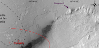
That is certainly worth staring at. Trying to place the terrain from the orbital images with the panorama view. I have no trouble identifying "rocky point" - particularly if I look at the crater rim in the background. That gives me an additional check! Those 360 panoramas are handy orientation devices.
However: In the North East direction, there is a somewhat circular depression that is possibly a crater or perhaps a deeply eroded basin in Glenelg. I can't really place it with the overhead view. A lot would depend on it's distance from MSL. Trying to tempt some Pano/orbilal comparisons. With the MERS we had programs that allowed distance information to be recovered from NAVCAM images, but I haven't used then for years and anyway the cameras are different.
~ North East Cropped section of Ed Truthan's Pano:
edit corrected direction

|
Posted by: ngunn Oct 7 2012, 08:46 AM
It would be great if someone could match visible features with Peter's map (see Geomorphology post 46), particularly the little 'island' at 137 27 05E, 4 35 32S which should be quite prominent.
Posted by: James Sorenson Oct 7 2012, 09:06 AM
The deck on Sol-60.
http://www.flickr.com/photos/43581439@N08/8062091286/
Posted by: jvandriel Oct 7 2012, 09:28 AM
Sol 59-60
The Navcam R Panoramic view.
Jan van Driel

|
Posted by: ngunn Oct 7 2012, 01:43 PM
For referring to features in panoramas a few informal landmark names can be useful. We already have Rocky Point. Some of us probably have our own private names for things (or is it just me?). Here's one I'd like to share. For me there's only one possible name for the hill at the leftmost visible extremity of Mt Sharp. It's Dumgoyne: http://www.google.co.uk/imgres?imgurl=http://www.rampantscotland.com/visit/graphics/dumgoyne1a.jpg&imgrefurl=http://www.rampantscotland.com/visit/bltower8.htm&h=393&w=455&sz=28&tbnid=6Q47g3aHnMY5zM:&tbnh=90&tbnw=104&zoom=1&usg=__GVQ80TtVNgbNWWCKDeGgi9ds1fU=&docid=ur00kyq-DfKoYM&sa=X&ei=OYRxUPffG4io0QXp7YCYBg&ved=0CD4Q9QEwBA&dur=3713
Posted by: stewjack Oct 7 2012, 02:42 PM
Until, and unless, there is an official name that sounds good to me.
If this is the overhead view of Dumgoyne it should remain in view in the N.E. for some time.
|
I couldn't find a good 2D horizontal view of Dumgoyne so I just marked it on my crop of EdTruthan's anaglyph.

|
Posted by: Ant103 Oct 7 2012, 03:30 PM
Better for stitching panoramic, I don't know I think I'm always like a noob at made it.
Sol 59 & 60 Navcam pan, with rover deck, Mount Sharp and natural sky.
http://www.db-prods.net/marsroversimages/curiosity.html#55
Posted by: Phil Stooke Oct 7 2012, 03:39 PM
Beautiful! Here is a circular version of it.
Phil
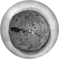
|
Posted by: ngunn Oct 7 2012, 04:22 PM
That's the one. It shows up rather well on this crop from Stu: http://www.unmannedspaceflight.com/index.php?act=attach&type=post&id=28283
EDIT: Here's another view of the Scottish version showing the "crater rim" beyond: http://s0.geograph.org.uk/geophotos/02/48/22/2482238_bd117844.jpg
And back to Mars: http://mars.jpl.nasa.gov/msl-raw-images/msss/00003/mcam/0003ML0000020000E1_DXXX.jpg
Posted by: Stu Oct 7 2012, 07:22 PM
If time/engineering requirements allow, now might be a good time for Curiosity to try some astrophotography - Earth and Jupiter are making a rather lovely pairing before dawn...
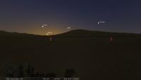
|
Zoomed in a bit...

|
And on October 10th Earth and Jupiter will be even closer, with Jupiter shining above Earth...
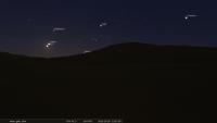
|
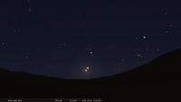
|
Not saying this should be done, would just like to see the pictures.
NOte: HUGE thanks to Ant for the Stellarium landscape file. Godsend.
Posted by: jmknapp Oct 7 2012, 07:23 PM
There are some vertical lines in that image:
|
...wonder what that's from?
Posted by: walfy Oct 7 2012, 08:01 PM
...wonder what that's from?
Sensor blooming, maybe?
Posted by: elakdawalla Oct 7 2012, 08:01 PM
http://www.truesenseimaging.com/support/reference-documents/doc_download/1-interline-image-sensor-smear
Posted by: mcaplinger Oct 7 2012, 08:10 PM
It's excess column charge from a hot pixel. Hot pixels are always forming from neutron hits from the RTG.
If somebody wants to do part of my job for me, you can find and track these as they develop in all four MSSS cameras.
Posted by: ugordan Oct 7 2012, 08:16 PM
Interesting, I thought these were "acquired" during cruise. Are there any rough estimates on the rate new ones are expected to occur due to the RTG?
Posted by: mcaplinger Oct 7 2012, 08:27 PM
Yes. The typical rate is [ever heard of ITAR?]
The images are all out there, one can amuse oneself by looking for new hot pixels.
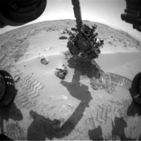
Posted by: Stu Oct 7 2012, 09:49 PM
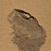
First scoop..!
|
Posted by: Ondaweb Oct 7 2012, 09:54 PM
|
|
I think it is the low area in this pic: http://petergrindrod.net/wp-content/uploads/2012/08/Gale-GIS-HiRISE-landing-site-topo.png
which is just above the second g in Glenelg.
Posted by: Stu Oct 8 2012, 12:56 AM
One small scoop for a rover, but another giant leap for planetary geology...
|
|
Posted by: belleraphon1 Oct 8 2012, 02:04 AM
Oh.... luv this Stu..... I remember Surveyor...
Craig
Posted by: stewjack Oct 8 2012, 02:29 AM
I looked at that image and could not see any island at that location. It seemed to be a location in a basin. The problem of not being able to measure distance accurately would probably make any identification difficult, but copying the image and then drawing an arrow to point out a feature would simplify the problem for whoever tries to solve your problem.
Crop of Peters Map
|
Posted by: ngunn Oct 8 2012, 07:54 AM
I was referring to the small rise in the middle of the basin at the lower right there. I think (though I'm not 100 percent sure) that it's visible as the middle-distance plateau almost at eye level, just to the right of Dumgoyne. The northern 'shore' of the basin that you delineate is also in view to the left of Dumgoyne.
Posted by: kenny Oct 8 2012, 10:39 AM
Just to mention in passing, I was walking near the Scotish Dumgoyne a few weeks ago, and have climbed it several times. It is a Carboniferous era volcanic plug marking the west end of a series of basalt sills which makes up the Campsie Fells (hills).
The arrival of Curiosity at Martian Glenelg is being celebrated by an event at the original Scottish Glenelg on October 20.
http://www.glenelg.co.uk/blog/space-stars-mars-programme-launched/
Speakers will be:
- Doug McCuiston, Director, NASA Mars Exploration Program.
- Bonnie Dunbar, Shuttle astronaut, who will also unveil the Glenelg Twinned with Mars sign set to become a permanent feature in the village.
- Prof John C. Brown, Scotlands Astronomer Royal.
Let me know if anyone plans to come.
Posted by: jmknapp Oct 8 2012, 11:31 AM
Anyone know why the mastcam images taken with the colored filters, such as the latest from sol 60 (e.g. http://mars.jpl.nasa.gov/msl-raw-images/msss/00060/mcam/0060ML0276000000I1_DXXX.jpg ) are small thumbnails only? I don't think any have been full frame to date.
Posted by: Floyd Oct 8 2012, 11:43 AM
Re: http://www.glenelg.co.uk/blog/space-stars-mars-programme-launched/
How I would love to come to Glenelg. I have also always wanted to visit the neighboring Isle of Skye, do a little hiking and have a glass of Talisker at the source. On my list of things I must do...
Posted by: ronald Oct 8 2012, 11:48 AM
I might be totally wrong, but some filtered images come down as greyscale images (4 to 6 mostly):
http://mars.jpl.nasa.gov/msl-raw-images/msss/00048/mcam/0048ML0216003000D1_DXXX.jpg and http://mars.jpl.nasa.gov/msl-raw-images/msss/00048/mcam/0048ML0216002000D1_DXXX.jpg
http://msl-scicorner.jpl.nasa.gov/Instruments/Mastcam/
Edit - Maybe better example:
http://mars.jpl.nasa.gov/msl-raw-images/msss/00044/mcam/0044ML0205001000D1_DXXX.jpg / http://mars.jpl.nasa.gov/msl-raw-images/msss/00044/mcam/0044ML0205002000D1_DXXX.jpg / http://mars.jpl.nasa.gov/msl-raw-images/msss/00044/mcam/0044ML0205003000D1_DXXX.jpg / http://mars.jpl.nasa.gov/msl-raw-images/msss/00044/mcam/0044ML0205004000D1_DXXX.jpg / http://mars.jpl.nasa.gov/msl-raw-images/msss/00044/mcam/0044ML0205005000D1_DXXX.jpg / http://mars.jpl.nasa.gov/msl-raw-images/msss/00044/mcam/0044ML0205006000D1_DXXX.jpg
and thumbnails (in colour):
http://mars.jpl.nasa.gov/msl-raw-images/msss/00044/mcam/0044ML0205001000I1_DXXX.jpg / http://mars.jpl.nasa.gov/msl-raw-images/msss/00044/mcam/0044ML0205002000I1_DXXX.jpg / http://mars.jpl.nasa.gov/msl-raw-images/msss/00044/mcam/0044ML0205003000I1_DXXX.jpg / http://mars.jpl.nasa.gov/msl-raw-images/msss/00044/mcam/0044ML0205004000I1_DXXX.jpg
Posted by: kenny Oct 8 2012, 01:13 PM
How I would love to come to Glenelg. I have also always wanted to visit the neighboring Isle of Skye, do a little hiking and have a glass of Talisker at the source.
If you make it along, I will buy you a glass of smokey T at the Glenelg Inn overlooking the misty Isle...and we can discuss the Martian Glenelg...
Posted by: fredk Oct 8 2012, 02:53 PM
Remember the MER shadow puppet shows? Looks like Currie can put on a show too:
http://mars.jpl.nasa.gov/msl-raw-images/proj/msl/redops/ods/surface/sol/00061/opgs/edr/fcam/FLA_402895937EDR_F0050104FHAZ00311M_.JPG
Posted by: eoincampbell Oct 8 2012, 03:55 PM
Kenny, wish I could be there, especially for the Martian ceilidh band 
Posted by: kenny Oct 8 2012, 05:29 PM
Their rhythms are off-beat and somewhat alien, yet insistent and compelling, perhaps even entrancing.... with a Gaelic name like yours, Eoin, you will be missed...
Posted by: Stu Oct 8 2012, 07:09 PM
Interesting. There's a JPL YouTube film of dust in Curiosity's scoop being shaken and vibrated...
http://www.youtube.com/watch?v=V10goCmY2FQ&feature=plcp
...but no pictures yet..
Posted by: Ant103 Oct 8 2012, 07:29 PM
Maybe it's a movie made on-board the rover. But this will be surprising regarding the size of the data to transmit.
Posted by: elakdawalla Oct 8 2012, 07:36 PM
No, it's just that Malin is holding some (usually the juiciest) Mastcam images for 24 hours before release, unlike Edgett who's letting MAHLI images go out pretty much immediately. 24 hours is not too long for me to wait, but you can bet I'm checking the raws page pretty frequently right now
Posted by: fredk Oct 8 2012, 07:49 PM
No obvious sign of dust being carried away by wind. It would be nice to do some careful frame subtraction (Spirit DD movie style) to look for subtle signs.
Posted by: mcaplinger Oct 8 2012, 07:55 PM
Are any of the Mastcam images being released in less than 24 hours? (Not counting press release images.)
Posted by: EdTruthan Oct 8 2012, 07:58 PM
You could take as Malin's indirect complement to this forum. If that series had come down today, one of us (I know I'd be all over it in a second) would have had that film rendered in about 5 minutes. Can't blame him for wanting to be the first, it's his baby. Hope we get more of these of films!
Posted by: elakdawalla Oct 8 2012, 08:00 PM
Actually, I don't know -- I thought thumbnails were, but I haven't paid close enough attention. My post originally didn't include the "some" bit but I wasn't sure if he was delaying all of them or not.
Posted by: stewjack Oct 8 2012, 08:12 PM
I am, as usual, uncertain what "small rise," you are referring to in the overhead view. I really can't see any small rise in a basin that looks like a plateau. However, I am fairly confident that I can identify what you describe as a "middle-distance plateau almost at eye level, just to the right of Dumgoyne" - in the Navcam view. My confidence is based on your description, as well as on my only seeing one feature that looks like a small plateau! I also think we agree on the identification of the northern shore of the basin. I would place that at about 450 -500 meters distant - if we are not both wrong.
Posted by: EdTruthan Oct 8 2012, 08:23 PM
Hmmm. Well, according to jmknapp's raw image browser, using the "sort by lag time" function the soonest any Mastcam image has ever come down (thumbnail or not) is 25 hours.... so there we are.
Posted by: ngunn Oct 8 2012, 08:28 PM
Thanks for persisting! I'll have one more go at explaining. On Peter's map http://petergrindrod.net/wp-content/uploads/2012/08/Gale-GIS-HiRISE-landing-site-topo.png it's about 250 metres from Glenelg at two o'clock - just high enough for an 'island' of yellow colour.
I think it may also be visible in the Bradbury Landing panorama.
Posted by: ronald Oct 8 2012, 09:50 PM
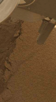
Nice http://mars.jpl.nasa.gov/msl-raw-images/msss/00061/mcam/0061ML0316000000E1_DXXX.jpg of the first scoop sample. Near the botton, slightly right off the middle is a strange piece - couldn't locate it in the navcam images though. Maybe something scraped off the rover(wheels)?
And what a nice and clean cut - you can even see the dust layers
|
Posted by: EdTruthan Oct 8 2012, 09:56 PM
Ok ngunn, look right in the center of this anaglyph (this thing pops right out in 3D). There's a Big Island there. Is that the island you're looking for? Based on the Mt. Sharp ridge lines in the background it would be just a bit north of due east from the MSL position on Sol 51 from which this anaglyph was made, so pretty well corresponds to the island you're referring to on Peter's map.
http://www.edtruthan.com/mars/Sol51-MC34-MC100-Crop-Of-Anaglyph-Draft.jpg
BTW this is a crop of a much larger anaglyph I'm working on from the Sol 51 Mastcams...
Posted by: Doc Oct 8 2012, 09:58 PM
I too noticed it ronald. Here is a cropped view
|
The full image reduced for context; at first I thought it was just another hot pixel.
|
More uralane?
Edit: Curiosity tweets that there is some speculation that it could be a piece of rover hardware. (Is Curiosity shaking herself to bits....?)
Posted by: ngunn Oct 8 2012, 10:10 PM
Responding to Ed Truthan: Yes I think that's it. Big/small - it's all relative. (It looks quite small on the map, and probably has no significance beyond helping us to orient ourselves) Great anaglyph!
EDIT: I should have said more. This anaglyph is the best realisation so far of the light-toned hollow at the outer boundary of the high thermal inertia unit.
Posted by: Doc Oct 8 2012, 10:26 PM
Sub frame images from the video are pouring in and some more:
Close up of the scooped area:http://mars.jpl.nasa.gov/msl/multimedia/raw/?rawid=0061MR0319001000E1_DXXX&s=61
Finally we might be able to see how the wind affected the falling dirt:http://mars.jpl.nasa.gov/msl-raw-images/msss/00061/mcam/0061MR0306001000E1_DXXX.jpg
Posted by: Jam Butty Oct 8 2012, 10:29 PM
Shake Rattle & Roll
Sol 61 scoop shaking,
3 frame animation covering about two and a half minutes of real time...
|
Posted by: ElkGroveDan Oct 8 2012, 10:35 PM
Nice anaglyph, it really shows the depression. It resembles a dry lake bed in Southern California's high desert. The only thing missing is a RAV4 parked out there.
Posted by: Phil Stooke Oct 8 2012, 10:37 PM
Curiosity can get to places even a RAV4 can't reach.
Phil
Posted by: Pando Oct 8 2012, 10:44 PM
She already has, Phil.
Posted by: Doc Oct 8 2012, 11:12 PM
Update on the http://mars.jpl.nasa.gov/msl/news/whatsnew/index.cfm?FuseAction=ShowNews&NewsID=1371
Posted by: pmetschan Oct 8 2012, 11:21 PM
Would they go as far as to dump the current sample in order to use MAHLI to take a look?
Posted by: Doc Oct 8 2012, 11:29 PM
By imaging I think they'll start with the 100mm Mastcam before doing something drastic with an arm that may be lacking a component (assuming it is from the arm).
Posted by: paraisosdelsistemasolar Oct 8 2012, 11:40 PM
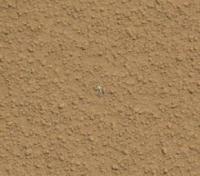
ChemCam images of the bright object:
|
|
It seems to me more a plastic object than a metallic one.
Posted by: stewjack Oct 8 2012, 11:41 PM
EDIT: I should have said more. This anaglyph is the best realization so far of the light-toned hollow at the outer boundary of the high thermal inertia unit.
Yep I am holding off. We now have much better data!
Posted by: nprev Oct 8 2012, 11:43 PM
Kapton tape fragment? That crap can get brittle. (I speak from experience.)
Posted by: fredk Oct 9 2012, 12:04 AM
Posted by: elakdawalla Oct 9 2012, 12:21 AM
Don't underestimate Malin

Anyway, I think the Chemcam images serve as a stereo pair? The lighting is quite a bit different, but there was some rotation of the mast between the two pictures, and I *think* that gives a little stereo separation. Maybe? I need your opinions on this one.

|
Posted by: climber Oct 9 2012, 12:44 AM
Let's fire the laser, we'll know for sure! 
Posted by: elakdawalla Oct 9 2012, 12:59 AM
OK, somebody check my work. According to http://www.geochemsoc.org/publications/geochemicalnews/gn145jun11/chemcaminstrumentsuite.htm, the ChemCam Remote Micro-Imager field of view is 20 mrad. The object measures 190 pixels long so it's 190 / 1024 · 20 = 3.71 mrad long. Multiply that by the mast height of 2.13 meters and you get the object being a minimum of 42.6 millimeters long. That is much bigger than I thought; I would've guessed it's much smaller, maybe because I'm used to MER images. But it's just as likely my math is off, so I'd appreciate a second opinion!
Posted by: Bjorn Jonsson Oct 9 2012, 01:13 AM
Assuming I understand everything correctly I get ~8 mm, i.e. using radians I get tan(3.71/1000) x 213 cm = 0.79 cm.
Posted by: fredk Oct 9 2012, 01:16 AM
I agree with Bjorn. 8 mm.
And I see no stereo in the chemcam pair. They'd have to move the whole rover to get a second viewpoint. It looks like they shot at different times to get different lighting.
Posted by: elakdawalla Oct 9 2012, 01:25 AM
I'm not at my best in the evening! Thanks guys. At least I was on the ball enough to make my mistakes here before publishing them to all the rest of the Internet :|
Posted by: Explorer1 Oct 9 2012, 01:28 AM
MAHLI can always look at it between scoops, right?
Posted by: elakdawalla Oct 9 2012, 01:29 AM
I understand they shot a jillion Mastcam-100 pics of it yesterday. At least some of those should've come down with the Navcams this afternoon but it seems we won't see those for 25 hours!
Posted by: dvandorn Oct 9 2012, 02:04 AM
Is there any way to tell if Little Shiny was present before they started vibrating the scooped sample? I can imagine little bits of kapton tape or similar things breaking off during the vibration cycle, but if this was there prior to the scoop vibration, maybe it's just a native bleb of melted metal or glass? There's no reason to believe you couldn't get such little blebs in the Martian soil -- there are likely a lot of sources of source material, and certainly enough impacts to generate little melted blebs every once in a while.
-the other Doug
Posted by: Pando Oct 9 2012, 04:29 AM
Most everything on the surface is covered with red dust. This one looks completely clean.
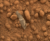
Posted by: ronald Oct 9 2012, 07:01 AM
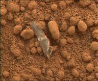
It's pretty obvious that this is not martian. Looks like some piece of foil.

|
Posted by: jmknapp Oct 9 2012, 11:28 AM
OK, now I have a word of the day--will try to use it in a sentence today.
Good to see that it's irregularly shaped and not so much like a mechanical part.
Posted by: ddan Oct 9 2012, 12:19 PM
It looks semi-transparent. You can see the pebble behind it.
Posted by: vikingmars Oct 9 2012, 01:58 PM
For sure, MAHLI could help...
Posted by: fredk Oct 9 2012, 03:01 PM
For sure it could, but the press release said "the rover team decided to refrain from using the rover's robotic arm", presumably until they identify the piece and determine that it won't harm the arm to move it.
MC100 won't match the resolution of chemcam, but will give some colour information.
Has anyone identified earlier images of that patch of ground, with any camera?
Posted by: paraisosdelsistemasolar Oct 9 2012, 03:46 PM
I've tried to make a quick match of Sol 60/61 pics of the same zone. Due to the resolution of NavCams only a little dark patch is visible, but I don't know if it's due to a shadow of a little rock or the grey strip seen on MastCam pics. Take a look by yourself:

|
Mod: EVERYONE! Read again rule 3.5: Avoid excessive quoting. If your reply will immediately follow the post you're replying to, do not quote it at all. If your reply refers to a post farther up in the thread, quote only that text that is relevant to your reply. Avoid quoting images.
Posted by: Doc Oct 9 2012, 04:50 PM
From your animation parais. there doesn't seem to be any difference. I would agree that the dark feature in the navcam images is in fact 'Little shiny' as dvandorn called it.
Mod: See above.
Whoops! Sorry there.
Posted by: pechisbeque Oct 9 2012, 06:22 PM
Could it be a scrapping from the corner of the scoop?
Maybe the scoop hit some rock beneath the sand that we can't see now.
In the scoop images it kind of looks like of the corners is slightly scratched.
Posted by: Stu Oct 9 2012, 07:23 PM
Personally I'm amazed we haven't seen more scraps of crud. We all saw the plume that went up when the descent stage hit the ground...and the heatshield got with a whack, too... those impacts could have sent a lot of light debris into the air, which had to come down somewhere, right? And we know Gale is a gusty place. Add those things together, and it's not a huge reach to imagine bits of impact debris fluttering and rolling across Curiosity's path, blown by the breeze, is it?
Posted by: atomoid Oct 9 2012, 07:26 PM
It's likely to be debris from EDL, we are downwind of the descent path aren't we?
a new but dimmer example of other bright bits http://www.unmannedspaceflight.com/index.php?showtopic=7471&st=315&p=192357&#entry192357
Posted by: Pando Oct 9 2012, 07:50 PM
A freudian slip, I presume?
I agree with Stu, and I'm sure we will come across more man-made stuff laying around as we drive along. I believe that it's expected that the area around the landing site would contain all kinds of debris, considering all the activity during EDL with the pyros firing, thrusters blowing, and parachute deploying...
Posted by: Stu Oct 9 2012, 08:03 PM
Haha! Oops!
Posted by: Phil Stooke Oct 9 2012, 08:14 PM
An update on MSL from the http://mepag.jpl.nasa.gov/meeting/oct-12/index.htmlmeeting which just concluded:
http://mepag.jpl.nasa.gov/meeting/oct-12/presentations/07_MEPAG-MSL-Oct2012F.pdf
Phil
Posted by: fredk Oct 9 2012, 09:17 PM
I'm going to go out on a limb, and say the little scrap appeared on sol60, during navcam imaging. Here's a comparison of two frames, 35 seconds apart:

|
A dark mark appears on the second frame (circled) and stays there on subsequent frames. The location matches the scrap's position in the MC image. Clearly the lighting is essentially identical between these two frames. However, these are zoomed to 200%, and we should be very wary of jpeg artifacts. Still, this change looks much greater than other small-scale differences which are clearly due to jpeg noise.
Posted by: Marvin Oct 9 2012, 09:56 PM
NASA is now saying this "Object Likely Benign Plastic from Curiosity Rover"
http://marsprogram.jpl.nasa.gov/msl/news/whatsnew/index.cfm?FuseAction=ShowNews&NewsID=1372
This reminds me of the infamous "bunny" after Opportunity landed. While some claimed NASA deliberately and cruelly ran over said bunny, it turned out to be a piece of the airbag.
NASA will also be holding a teleconference at 11 a.m. PDT (2 p.m. EDT) on Thursday, Oct. 11.
Posted by: atomoid Oct 9 2012, 11:42 PM
You can see that white rabbit and about a half-dozen other colorful little bits of flotsam scattered in http://vandenk.free.fr/Oppy-Mission%20Succcess%20Panorama.html or view the http://marswatch.astro.cornell.edu/pancam_instrument/images/Opportunity_Mission_Succcess.jpg.
Posted by: Decepticon Oct 10 2012, 12:11 AM
OMG I never laughed so hard! That was great.
Posted by: fredk Oct 10 2012, 02:54 AM
Speaking of Oppy's detritus, I think the best example was the little spring/coil that's in atomoid's avatar!
Posted by: djellison Oct 10 2012, 03:06 AM
Little? That's one of the heatshield push off springs - about the size of a large beer can.
Posted by: Astro0 Oct 10 2012, 06:45 AM
So while we were all staring at the little shiny, there were some other interesting things going on in the scene.
A few little soil movements during the shaking operation.
The slide in the scoop hole is interesting for the amount the material moves 'downslope'.
|
|
Click tio animate.
Posted by: ronald Oct 10 2012, 06:54 AM
Two sol 59 pans - right one is only partial ...
|
|
|
|
http://dl.dropbox.com/u/5875127/msl/0059MR026700X000E1_DXXX_p.jpg
Fantastic lighting in this sol 60 http://mars.jpl.nasa.gov/msl-raw-images/proj/msl/redops/ods/surface/sol/00060/opgs/edr/ncam/NRA_402833090EDR_F0050104NCAM00322M_.JPG
Posted by: EdTruthan Oct 10 2012, 07:04 AM
Animated GIF Anaglyph of 1st Martian Soil Scoop - Sol 61
http://www.edtruthan.com/mars/Sol61-Front-Hazcam-Soil-Scoop-Animated-Anaglyph.gif
Posted by: Antonb Oct 10 2012, 07:18 AM
Can anyone explain the strange "snail trails" in this Sol 62 Navcam R image? (Original http://mars.jpl.nasa.gov/msl/multimedia/raw/?rawid=NRA_403004986EDR_S0050104NCAM00327M_&s=62)

|
Posted by: blueaeshna Oct 10 2012, 12:01 PM
That looks to me like something has dripped some (hydraulic?) fluid that's then run along the strut, a bit worrying, whats usually above this?
Posted by: Ant103 Oct 10 2012, 12:12 PM
For me, I have the impression that's the little particles ejected by the thruster of the Skycrane during the landing, that have moved because of the rover movements. During "rolling" on the metal, they may have clean the surface of some dust, resulting in a darker rendering.
Posted by: Floyd Oct 10 2012, 01:20 PM
Mars Rovers have never had hydraulic systems or actuators.
Posted by: mhoward Oct 10 2012, 02:10 PM
Context for the partial sol 59 Mastcam M-100 mosaic
http://www.flickr.com/photos/marscat/8073951486/
Posted by: djellison Oct 10 2012, 02:26 PM
It's clearly not - look at this image of the same area from a different time on the same sol
http://mars.jpl.nasa.gov/msl/multimedia/raw/?rawid=NRA_402992903EDR_S0050104NCAM00327M_&s=62
It's just scratches on the top of a milled metal surface.
Posted by: fredk Oct 10 2012, 03:18 PM
Posted by: stewjack Oct 10 2012, 03:47 PM
Thanks mhoward. Useful information. So much more information than with the MER rovers & IMO: The terrain is as confusing as the Husband hill inner basin.

Posted by: mhoward Oct 10 2012, 04:30 PM
Yes; imagine when she actually drives down there. From the outside, seeing this unfold, it feels like a continuation of Spirit's mission. I love it.
Posted by: Bill Harris Oct 10 2012, 05:44 PM
That might be a good test for organic signatures.
--Bill
Posted by: dvandorn Oct 10 2012, 06:31 PM
That might be a good test for organic signatures.
Only if the target returns fire...

-the other Doug
Posted by: belleraphon1 Oct 10 2012, 06:38 PM
Resume Working with First Scooped Sample
"Investigation of a small, bright object thought to have come from the rover may resume between the first and second scoop. Over the past two sols, with rover arm activities on hold, the team has assessed the object as likely to be some type of plastic wrapper material, such as a tube used around a wire, possibly having fallen onto the rover from the Mars Science Laboratory spacecraft's descent stage during the landing in August."
http://www.jpl.nasa.gov/news/news.php?release=2012-316
Posted by: EdTruthan Oct 10 2012, 07:49 PM
Here's the Sol 59 (partial) MC100 mosaic whith some white balancing. This is a really enthralling rock field. Not only that the great number of slabs exposed appear to be composed of very thin layers, but that they're apparently so well cemented they tend to resist collapse. And their apparently tilted (but formation consistent) angle of exposure is interesting to ponder.
http://www.edtruthan.com/mars/Sol59-MC100-(Partial-Mosaic)-With-W-Balance.jpg
AND... there's also a sister MC100 mosaic taken on Sol 60 (not down yet) with a few meter basline differential that'll be excellent for stereo viewing of this field when the full frames are available. Here's a quick test draft utilizing a thumbnail mosaic for the left eye...
http://www.edtruthan.com/mars/Sol59-(with-60Thumbs)-MC100-Partial-Anaglyph.jpg
...being a dedicated MC100 pair this will be razor sharp when the Sol 60 full frames are down.
EDIT: The above anaglyph is now available in Full Resolution two posts down or click http://www.unmannedspaceflight.com/index.php?s=&showtopic=7495&view=findpost&p=193089.
Posted by: fredk Oct 11 2012, 12:33 AM
Sol 60 M100's coming down now. Here are Phil's sea lions, in sol59/60 long baseline M100 stereo:
|
Edit: here's the side-by-side version:
|
The one in front (the "petrified log") looks more like a sea lion that somebody sat on!
Posted by: EdTruthan Oct 11 2012, 01:08 AM
Ask and ye shall receive! Here's the Full Resolution Anaglyph. Sols 59 & 60 MC100 pairing...
http://www.edtruthan.com/mars/Sol59-and-60-Glenelg-Rockfield-Mosaic-Anaglyph.jpg
Oh Wow...
Edit: Just went in and cloned out those pesky MC100 dirt spots that float in mid-air and realigned the separation of the sides just a hair. A pairing like this one, that has a pretty wide baseline (compared to the target's distance from MSL), makes the foreground and distant objects vary wildly in the separation of colors. I think this one strikes a decent balance that makes all depth fields accessible without too much eye adjustment though.
Edit 2: A slightly more white balanced version of the anaglyph with reduced color separation in the area specific to the slabs to support very close zooming on them has been posted http://www.unmannedspaceflight.com/index.php?s=&showtopic=7495&view=findpost&p=193245.
Posted by: ronald Oct 11 2012, 06:18 AM
Nice ones Ed and Fred! The side-by-side image is really challenging to focus.
Did those rocks below do have names allready?
|
Sol 59 - Mastcam 100
Posted by: jmknapp Oct 11 2012, 10:30 AM
Anaglyph of the one on the right:
|
Posted by: ngunn Oct 11 2012, 11:20 AM
Did those rocks below do have names allready?
They do now.
Posted by: Stu Oct 11 2012, 03:32 PM
I'm looking at this and thinking "VERY recent fall, of little meteorites..." ?
|

Posted by: kenny Oct 11 2012, 03:50 PM
Fascinating....or one friable one which simply fell apart after a fairly gentle landing....
Posted by: xflare Oct 11 2012, 03:54 PM
I think those are chemcam laser shots.
Posted by: Stu Oct 11 2012, 04:26 PM
Hmmm. Still think they're meteorites. Looks like solid objects in there...
|
Posted by: fredk Oct 11 2012, 05:07 PM
Definitely laser pits:
http://mars.jpl.nasa.gov/msl-raw-images/proj/msl/redops/ods/surface/sol/00050/opgs/edr/ccam/CR0_401929186EDR_F0042778CCAM01050M_.JPG
Meteorites wouldn't fall in a raster pattern!
Posted by: Astro0 Oct 11 2012, 11:23 PM
ADMINmode: A bunch of posts related to observations discussed in the telecon for the period of the 'Drive to Glenelg' topic moved http://www.unmannedspaceflight.com/index.php?showtopic=7471&view=findpost&p=193130.
Posted by: Astro0 Oct 12 2012, 12:41 AM
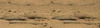
Sol 59 Mastcam (right) image of the wheel tread pattern. Curiosity certainly makes an impression.
|
Well worth a look at full size image available on my http://astro0.wordpress.com/msl-tracks-sol59/ - or download http://astro0.files.wordpress.com/2012/10/sol59_mastcamright_treadmarks.jpg 11.7mb
Posted by: dombili Oct 12 2012, 12:53 AM
Animated GIF of the turret from SOL 65 (Navcam L - Navcam R)
|
|
Posted by: Jam Butty Oct 12 2012, 02:26 AM
Sol 65 MAHLI stereo of 'The Fragment'
flicker gif...
|
crossed pair...
|
(edit) http://www.youtube.com/watch?v=uvlsRFgYP6c&feature=plcp
Posted by: fredk Oct 12 2012, 03:41 AM
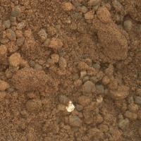
Another bright bit to add to the list, at the bottom of the frame:
http://mars.jpl.nasa.gov/msl-raw-images/msss/00064/mcam/0064MR0285029000E1_DXXX.jpg
(And there's an old one that you could add as well in http://www.unmannedspaceflight.com/index.php?s=&showtopic=7426&view=findpost&p=191002)
Posted by: ronald Oct 12 2012, 07:21 AM
Partial Sol 64 pan - just for the overview:
|
|

|
http://dl.dropbox.com/u/5875127/msl/0064MR028500X000E1_DXXX_L.jpg
Posted by: Stu Oct 12 2012, 08:55 AM
Wow, this is a helluva place isn't it?
Posted by: nprev Oct 12 2012, 09:34 AM
It is indeed, Stu, and thanks for the beautiful imagery!!!
EDIT: Apologies, Ronald; my mistake, and thank you VERY much!!!!
From this perspective it looks like the entire area might just be a floodplain. Amazing.
Posted by: walfy Oct 12 2012, 03:18 PM
Took Jam's work on this to make a quick anaglyph:
|
Posted by: SpaceListener Oct 12 2012, 03:52 PM
Mmm... I seems it is not a fallen thing unless it is somewhat kind of chemical reaction.
Posted by: dvandorn Oct 12 2012, 04:32 PM
This is not to say that we haven't seen quite a large number of mini-impacts (especially in the Meridiani ripple fields). I'd guess those kinds of tiny craters are primarily secondary impacts where small gravel is spit out of nearby impacts.
However, I agree with the majority, here. The image in question looks like ChemCam laser hits on unconsolidated material to me.
-the other Doug
Posted by: ngunn Oct 12 2012, 06:01 PM
I don't suppose we'll get to visit the far end of this basin but it's striking that the material forming the basin rim there is noticeably darker and less obviously stratified than nearer 'shores'. I think that would be consistent with it being a terminal moraine (amongst many other possibilities no doubt).
http://mars.jpl.nasa.gov/msl-raw-images/msss/00064/mcam/0064MR0285016000E1_DXXX.jpg
Posted by: atomoid Oct 12 2012, 06:15 PM
http://mars.jpl.nasa.gov/msl-raw-images/msss/00064/mcam/0064MR0285029000E1_DXXX.jpg
(And there's an old one that you could add as well in http://www.unmannedspaceflight.com/index.php?s=&showtopic=7426&view=findpost&p=191002)
Thanks for the heads-up, indeed http://www.unmannedspaceflight.com/index.php?s=&showtopic=7471&view=findpost&p=192357keeps growing.
Surprising to me that the SOL 60 scrap (has it been positively identifed as tape wrap vs pyro scraps?) http://www.unmannedspaceflight.com/index.php?act=attach&type=post&id=28541 (thanks Jam) http://www.jpl.nasa.gov/news/news.php?release=2012-316 "possibly having fallen onto the rover from the Mars Science Laboratory spacecraft's descent stage during the landing in August".
..perhaps that was a mistatement or misconveyance.. it seems unlikely to me that it would have somehow stuck 'onto the rover' though all that EDL thrashing just to be deposited here much later by some unknown 'release' event. It seems far more likely it simply fell to this location from the EDL sequence, perhaps blown a few meters or so, as it looks quite lightweight.
Anyone know if the entry path and wind directions rule this out? im under the impression we are in a location where we can expect to see more EDL confetti.
Posted by: ronald Oct 12 2012, 06:22 PM
Hmm - I was just curious what http://mars.jpl.nasa.gov/msl-raw-images/msss/00064/mcam/0064ML0327000276M0_DXXX.jpg would show.
http://dl.dropbox.com/u/5875127/msl/0064ML0327_X10001-0251_v4.m4v
In case it does not work in your browser you might need to dl it first. http://dl.dropbox.com/u/5875127/msl/0064ML0327_X10001-0251_v1.m4v is another one with other compression.)
[edit]: video runs with 15 fps ...
Posted by: elakdawalla Oct 12 2012, 07:46 PM
Oh, awesome! The video shows the portion door opening up, and then the little portioned sample being dropped out. The "spit" part of the "rinse and spit"
Posted by: jamescanvin Oct 12 2012, 08:52 PM
Sol 64 mastcam100 panorama. What an unbelievable place this is!
http://www.nivnac.co.uk/mer/index.php/msl64
Posted by: ngunn Oct 12 2012, 09:18 PM
And what an incredible job you've done with it!!! I'll be walking around here for longer than the rover I think.
Posted by: empebe Oct 12 2012, 10:06 PM
soto voice from behind curtain :-
WOOOOW
Thanks
Mike
Posted by: Eyesonmars Oct 12 2012, 10:15 PM
Thank you to the Taxpayers, NASA, JPL, everyone on the MSL team, the Planetary Society, and last but not least to all of our image experts here on UMSF for these incredible images.
I've been scanning the fore and mid ground on these images hoping to spot a rounded cobble or two. We probably aren't in close enough yet but has anyone spotted one ?
Posted by: Eyesonmars Oct 12 2012, 10:36 PM
http://dl.dropbox.com/u/5875127/msl/0064ML0327_X10001-0251_v4.m4v
In case it does not work in your browser you might need to dl it first. http://dl.dropbox.com/u/5875127/msl/0064ML0327_X10001-0251_v1.mv4 is another one with other compression.)
[edit]: video runs with 15 fps ...
FYI: after downloading I had to rename these files from mv4 to m4v to get them to work
Posted by: Ant103 Oct 12 2012, 11:24 PM
My take on this stunning panorama, with an incredible feeling of relief. This is pleasure to scroll around, always discovering some nice places.
http://www.db-prods.net/marsroversimages/curiosity.html#60
Posted by: atomoid Oct 13 2012, 01:57 AM
golly gee whiz... speechlessly nice scnenery coming in.. its striking how high the tau is in Gale, you can barely make out the ridge details lost behind all that haze and the crispness of the large blocks strewn about on the right looking like ancient upturned roadbed.
Ant103 i really love the interface you've set up for your panos, everything is so accessible in timeline context.
Posted by: CosmicRocker Oct 13 2012, 04:58 AM
Posted by: ronald Oct 13 2012, 08:46 AM
Fixed it - Thank you!
Posted by: Astro0 Oct 13 2012, 01:41 PM
With just a dash of artistic licence

|
Posted by: udolein Oct 13 2012, 03:12 PM
My take of the Sol 64 video about the 1st probe's sample release of the CHIMRA:
http://www.marspages.eu/media/archive4/science_laboratory/16scooping/Sol64_Video3.gif
http://www.marspages.eu/media/archive4/science_laboratory/16scooping/Sol64_Video3-br.gif
The animated gif consists of the first 130 images of the 255 image sequence until the sample release which is shown in time lapse.
Earthlike colours and displayed with 10 fps.
Enjoy, Udo
Posted by: eoincampbell Oct 13 2012, 05:10 PM
Lovely touch, brilliant !
Posted by: climber Oct 13 2012, 06:06 PM
Astro, if I forget "lock screen" on my tablet....I just get mad Nice anyway!
And what you're delivering these days, Ant, is...more than I can bear!
I'm definetly on Mars, thanks
Posted by: EdTruthan Oct 13 2012, 06:44 PM
Here's and updated version of the Sol 59 & 60 MC100 anaglyph pairing of the rock slab field with an emphasis on reducing the separation of the colors in the area specific to the rock slabs in foreground center and right so as to support very close zooming on them. There's also a shift toward white balancing too to differentiate rock types just a hair.
http://www.edtruthan.com/mars/Sol59-and-60-Glenelg-Rockfield-Mosaic-Anaglyph-V2.jpg
One particularly interesting slab (that I've dubbed "Sunsetter" for it's similarity to an awning of the same name) is this guy, who seems so well cemented to his underlying layer so as to almost defy gravity. There's evidently more rock supporting him that is readily visible in the shadow if brightened, but this field is full of interesting characters like this. Has anyone been able to calculate based on the distance to this rock field how large this guy might be, and for that matter all these slabs and Phil's sea lions?
http://www.edtruthan.com/mars/Sol59-and-60-Glenelg-Rockfield-Mosaic-Anaglyph-V2-Sunsetter-Rock.jpg
Posted by: Ant103 Oct 13 2012, 06:52 PM
Absolutely great Astro0 !
Thank you Climber, but more is coming
Posted by: ronald Oct 13 2012, 08:38 PM
2nd scoop:

|
Posted by: ngunn Oct 13 2012, 09:15 PM
I have a question about ripple/dune formation that I hope someone here can help me with. Particles in terrestrial dunes are usually quite well sorted by size, yet this ripple is powdery and dark on the inside with a surface covering of lighter-toned and much coarser sand grains. I can understand wind ablation selectively removing fines and leaving behind a surface of bigger grains, but only if the two were thoroughly mixed in the first place, i.e. not well sorted at all. I wouldn't expect this in a ripple/dune constructed by wind transport.
Posted by: nprev Oct 13 2012, 09:21 PM
I think that the bright coating on dunes (and on almost everything on Mars, really) is due to dust settling after storms. Given the very low atmospheric pressure, I'd guess that the bright stuff consists of EXTREMELY fine grains...don't know nearly enough about minerology to say what they're made of, but gotta have some iron oxide or another to account for the color.
In any case, if these are extreme fines it would explain why they don't seem to settle appreciably into the dunes themselves over time. Additionally, dust storms seem to be by far the most active material redistribution process on Mars, so this stuff can be easily replenished if random winds sweep it off.
Posted by: ngunn Oct 13 2012, 09:51 PM
OK, but leaving dark and light out of it there is still the question about grain sizes. How do you form a powdery dune coated with coarse sand?
Posted by: serpens Oct 13 2012, 10:07 PM
This armouring effect is much like Spirit's Serpent Dune and seems widespread. I think there is more to this than simple deflation. Possibly a variation on the 'cornflakes syndrome' where the larger particles rise to the surface. Thermal induced vibration?
Posted by: ngunn Oct 13 2012, 10:26 PM
I really don't know what to think. If its deflation there must have been a heck of a lot of it and of course bigger bits in the mix to start with (also required by the cornflakes scenario).
Posted by: helvick Oct 13 2012, 10:26 PM
Ngunn , assuming (relatively) rare atmospheric conditions that can move heavier grains and smaller grains together separated by long periods where only lighter grains can be moved it seems logical to me that the process would end up with dunes\ripples that have a much higher percentage of fine grain material internally with a much higher relative proportion of coarser material right at the surface layer. This is similar to the type of sorting process that leads to desert pavement here on Earth but on a different scale. On Mars the time-frames could be very long indeed and the difference in atmospheric density ( and lack of moisture ) would result in this operating on much smaller grain sizes, which is how this appears to me.
I'm not interested to know how this does operate here on Earth so I've now got a half dozen sand dune papers open for bedtime reading. I'll post anything interesting I find.
Posted by: dvandorn Oct 14 2012, 01:23 AM
Also, remember that the ripples have a cemented layer at top. Perhaps there were multiple cemented layers produced by multiple episodes of cementation, and the uppermost layers are breaking down into the larger-grain fines?
-the other Doug
Posted by: ngunn Oct 14 2012, 07:51 AM
I also wondered if the larger grains could be composites made from the fine stuff, but they really don't look like that. They're a different colour for a start. (On reflection I don't think nprev's dust-mantling argument covers that because then they would look different where disturbed by the scoop and I don't think that's the case in the close-ups we have.)
Helvick, your story might work but I'm struggling to believe it and I wish I could think of a better one. The problem is that dunes/ripples are usually understood as constructive landforms, not residual shapes left by removal of material.
Posted by: ronald Oct 14 2012, 08:58 AM
This might give some answers - http://www.google.de/url?sa=t&rct=j&q=mer%20dust%20crust&source=web&cd=2&cad=rja&ved=0CCcQFjAB&url=http%3A%2F%2Fmeetings.copernicus.org%2Fwww.cosis.net%2Fabstracts%2FEGU06%2F05489%2FEGU06-J-05489.pdf&ei=U316UPDsC8bKsgbghYCYAw&usg=AFQjCNG12KrBFPfihM-TCDqIwMiZq4hkgw
Posted by: ngunn Oct 14 2012, 09:47 AM
Very good reference ronald. There's enough in that abstract to show it's not a trivial question! Maybe the experts have it fully understood by now but if not surely Curiosity will finish the job.
Posted by: atomoid Oct 14 2012, 10:13 AM
It seems like salty condensation deposited atop ancient deflated pavement armours against further deflation, allowing a nascent film the time to evolve into a thicker crust.
Posted by: ronald Oct 14 2012, 08:38 PM
http://mars.jpl.nasa.gov/msl-raw-images/proj/msl/redops/ods/surface/sol/00067/opgs/edr/ncam/NRA_403440714EDR_F0050104NCAM00318M_.JPG as if the second charge is gone through.
Below just a part of the next exciting pan - sol 66 mastcam:

|
I totally agree with EdTruthan that it would be nice to know how big those rocks are.
Posted by: Explorer1 Oct 14 2012, 08:51 PM
I don't suppose the Mystery Man has shown up at Gale yet?
Posted by: EdTruthan Oct 14 2012, 09:01 PM
On the topic of particle sizes in dune encrustation as compared to its underlying material and the possible causes for it, there's a pretty good chapter in the 2009 publication "Dark Dunes on Mars" by planetary geologist http://www.dlr.de/pf/en/desktopdefault.aspx/tabid-156/220_read-6530/sortby-lastname/ of the German Aerospace Center Institute of Planetary Research about Martian dune induration and imobilization: http://www.diss.fu-berlin.de/diss/servlets/MCRFileNodeServlet/FUDISS_derivate_000000005241/11_Chapt5.7.pdf?hosts= that references Spirit's "Serpent" dune (with photos) and offers some hypotheses about the induration processes at work. The entire publication appears to be available too, in a series of PDF's http://www.diss.fu-berlin.de/diss/receive/FUDISS_thesis_000000008848. Have only had a chance to scan through some of it, but it looks pretty interesting.
Posted by: serpens Oct 14 2012, 09:48 PM
The possible inter-granular cementing to form a duricrust over timescales of say 10^6 years doesnt really address ngunns question. It seems that the there is a very thin layer of cemented sand particles surfacing dunes/ripples that are made up of silt. The question is how this well sorted structure formed.
It seems logical that as the atmospheric pressure dropped erosion effectively ceased, existing sand was consolidated in deposition sites, saltation diminished until even silty dunes froze. Overall Mars seems pretty much sand depleted. But the larger sand particles should have ceased saltating before the silty particles. So why have the larger particles ended up on the surface of the dunes?
Posted by: ngunn Oct 14 2012, 09:49 PM
Great stuff, thanks for the links.
EDIT: Serpens I've just read your post. I think we can take it that the large grains formed in situ from the finer dune material (plus surface dust) by some sort of coagulation process, a process sketched out in the literature but not really understood in detail yet.
Posted by: serpens Oct 14 2012, 10:13 PM
While there is accretion, the armouring grains are still much larger than the interior silt. For instance 'Gallant Knight' has rounded grains 3 times the size of the internal armouring the surface. Purgatory dune showed larger cemented grains armouring the silt. The missing part of the puzzle remains why the large grains ended up on the surface.
Posted by: dvandorn Oct 14 2012, 10:23 PM
The one depositional process that has continued at a pretty steady state through to the present day is impact. Perhaps, as the atmospheric density declined and the armoring process proceeded, a relatively higher impact flux distributed larger-grained impact debris on top of dunes and ripples composed of finer grains, which were already in the midst of developing indurated surfaces.
-the other Doug
Posted by: ngunn Oct 14 2012, 10:26 PM
"The missing part of the puzzle remains why the large grains ended up on the surface."
The answer (surprising though it is) appears to be - because they formed there.
Posted by: Eyesonmars Oct 15 2012, 12:38 AM
There is an ongoing discussion over in the "temperature and pressure at Gale ..." topic that might be relavent to this discussion. Briefly, recent mars climate simulations suggest the atmosphere cycles from a near vacuum to almost double it's current mass over very short geologic time spans with the high density periods being of briefer duration. When the 2010 discovery of massive CO2 south polar deposits are incorporated into the model the cycles are more pronounced.
Posted by: vikingmars Oct 15 2012, 06:01 AM
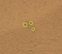
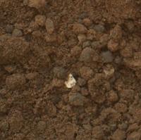
What are those "shiny" little grains made of ?
http://mars.jpl.nasa.gov/msl-raw-images/msss/00067/mhli/0067MH0008000000R0_DXXX.jpg
(see yellow arrows)

|
Posted by: ngunn Oct 15 2012, 07:35 AM
The undersides of overturned crust granules?
Posted by: Tesheiner Oct 15 2012, 07:47 AM
http://www.unmannedspaceflight.com/index.php?s=&showtopic=7413&view=findpost&p=189070. I presume you didn't attempt searching for "mystery man" on the MSL section.
Posted by: jmknapp Oct 15 2012, 08:46 AM
Just a WAG: hematite (like at http://www.gps.caltech.edu/~grotz/Publications/Publications_files/2006_Arvidson_Meridiani.pdf)?
I was torturing a recent MAHLI shot with Photoshop and came up with this:

|
Maybe a trick of the processing, but the small darker grains brought to mind hematite/magnetite as seen in beach sand. Hematite may be present in the vicinity, per this paper to be presented at a https://gsa.confex.com/gsa/2012AM/finalprogram/session_30627.htm next month:
https://gsa.confex.com/gsa/2012AM/finalprogram/abstract_208987.htm
Posted by: Actionman Oct 15 2012, 01:26 PM
Didn't Curiosity bring with it a magnet to test the hematite Blueberries?
Posted by: Phil Stooke Oct 15 2012, 01:47 PM
"The one depositional process that has continued at a pretty steady state through to the present day is impact. Perhaps, as the atmospheric density declined and the armoring process proceeded, a relatively higher impact flux distributed larger-grained impact debris on top of dunes and ripples composed of finer grains, which were already in the midst of developing indurated surfaces.
-the other Doug"
Timescales, Doug. Things like these drifts or ripples are geologically recent, and would be expected to change rapidly - not every year, but certainly every 10000 years or a few times that. At Meridiani I think Matt Golombek estimated 100000 years for significant changes to the big drifts traversed by Opportunity. Over that time you don't see any change in impact rates, which would be overwhelmed just by chance spatial variations.
Phil
Posted by: jmknapp Oct 15 2012, 02:27 PM
I think it was in connection with the RAT and designed to pick up small particles? I gather that hematite generally isn't very magnetic, unlike magnetite & some other iron-rich minerals. Hematite brings with it a certain frisson in Mars studies because it forms in standing water.
Posted by: centsworth_II Oct 15 2012, 05:10 PM
Re: the dark, shiny grains. It looks to me like they may just be surface nodules that have been cleared of the light colored dust covering all the other nodules. Below is a crop of vikingmars' posted image with some of my own yellow arrows added. Perhaps all the large granules/nodules would look as shiny and dark if the dust were blown off of them. Aren't they after all make of clumps of the same dark sand that fills the interior of the drift?

|
Posted by: atomoid Oct 15 2012, 05:30 PM
if the grains were originally shiny from polishing, they get 'cleaned' because the adherence of the atmospheric dust-salt condensation cements the fallen dust particles together around the grains and then the sand grains drop out of their weak sockets as the soil is disturbed by MSL, revealing portions of shiny grain, as the salty soil particles have a greater affinity to their own kind rather than to the grains. If the grains' polish doesnt remain from ancient water action or by mineral composition alone, some sort of residual brine shellac could be coating them?
Posted by: Actionman Oct 15 2012, 05:53 PM
Hematite will conduct magnetism somewhat and the Mars hematite as a compound, may have elements mix in it that enhance this conducting and in the very cold Martian night may even become a little magnetic .
Might be a cause of the dune affect in some way...
Posted by: serpens Oct 15 2012, 09:49 PM
My take is that the shiny grains are those that have been buried until exposed by the trenching. There was a similar visual effect in an early Opportunity wheel trench when berries that had been overrun and buried were exposed. I think the dark silt is the same material as the grains, just more broken down by erosion and the covering of dust on the armouring grains gives an illusion of accretion. There is of course accretion in the form of the cementing of grains to form the duricrust but the larger grains would have been transported here by saltation.
Posted by: nprev Oct 15 2012, 11:30 PM
Funny.
However, it is unlikely in the extreme that magnetic effects had any effect whatsoever on dune formation or hematite grain-sorting on Mars. For one thing, Mars has no extant planetary magnetic field, and the dunes were certainly formed well after that shut off. Additionally, hematite is EXCEEDINGLY weakly magnetic at best; frankly, I wouldn't characterize it as magnetic material at all.
Grain sizes & weights combined with local wind patterns & strength are almost certainly the prime determinants. Let's see what the pros say after the dust settles (ta-da, dah!)
Posted by: ronald Oct 16 2012, 06:42 AM
In case someone missed it - there is again some http://astrogeology.usgs.gov/news/item/sol-68-update-on-curiosity-from-usgs-scientist-ken-herkenhoff-schmutz about http://mars.jpl.nasa.gov/msl-raw-images/msss/00067/mhli/0067MH0079000006R0_DXXX.jpg (in the scoop trench).
|
|
|
Posted by: ronald Oct 16 2012, 09:47 AM
Some more from sol 66 - I asume Damien will release a nice full pan when all data is down then.

|
http://dl.dropbox.com/u/5875127/msl/0066MR029300X000E2_DXXX_L.jpg
Some nice and interesting rock formations and some more white stuff lying around ...
Edit: To not spam the thread only with my posts here is a link to a nice http://dl.dropbox.com/u/5875127/msl/0066ML_R_0293037000E1_DXXX.jpg
Edit2: BTW - I wonder where the debate has gone to, which was here some hours ago above my posts.
Posted by: belleraphon1 Oct 16 2012, 11:26 AM
As noted the Curiosity team have certainly taken note of the bright particles...
"Confidence for going ahead with the third scooping was based on new assessment that other bright particles in the area are native Martian material. One factor in that consideration is seeing some bright particles embedded in clods of Martian soil. Further investigations of the bright particles are planned, including some imaging in the Sol 69 plan."
http://www.jpl.nasa.gov/news/news.php?release=2012-323
Posted by: Harder Oct 16 2012, 04:24 PM
For those not (yet) following the daily news from Astrogeology's Ken ( MSL FAQ #12): Sol 69 news = MRO in safe mode; no news yet impact Glenelg program
Posted by: pmetschan Oct 16 2012, 06:14 PM
To the extreme novice, bright material among all this would seem to me to be very very significant. Is there a reason why the science team isn't going bananas over these "native" bright materials? Is there some mineral that would be present on the surface that we should be so hum hum about?
Posted by: Phil Stooke Oct 16 2012, 06:31 PM
Feldspar!
Most minerals here will be the ho-hum crust of Mars messed around by the Gale impact and brought in here by the mud flows or whatever built the alluvial fans emanating from the crater walls, or the winds which built this little dusty drift. The interesting stuff will be in outcrops, not here. This stop was mostly about cleaning the sample scoop and sample analysis system before they get to the good stuff. Basic rule - outcrops good, loose stuff boring. Not entirely boring of course, it is Mars after all, but outcrops are where the really interesting stuff will be.
Phil
Posted by: stevesliva Oct 16 2012, 06:39 PM
His detailing of the "schmutz" concerns on http://astrogeology.usgs.gov/news/item/sol-67-update-on-curiosity-from-usgs-scientist-ken-herkenhoff-getting-the-scoop and http://astrogeology.usgs.gov/news/item/sol-68-update-on-curiosity-from-usgs-scientist-ken-herkenhoff-schmutz are also informative.
Posted by: stevesliva Oct 16 2012, 06:41 PM
Looks like ronald beat me to the link in the previous post. In any event-- they think it's nonnative schmutz.
Posted by: ronald Oct 16 2012, 07:29 PM
Oh, I'm sorry - did not want to hurt anyone
To sad that the 34mm pan from Sol 66 had some serious http://mars.jpl.nasa.gov/msl-raw-images/msss/00066/mcam/0066ML0296018000E1_DXXX.jpg issues - so only a slim pan this time.
|
|
Really some http://mars.jpl.nasa.gov/msl-raw-images/msss/00066/mcam/0066ML0296008000E1_DXXX.jpg rocks nearby!
Posted by: dvandorn Oct 16 2012, 07:43 PM
You think so? Haven't noticed much of anything yet that appears feldspathic, and IIRC earlier landers found feldspathic materials primary as very fine grains in the ubiquitous dust layer. Same thing with the carbonates -- they're there, but mostly as very fine grains well-mixed into the primarily basaltic dust.
Heck, even the fine-grained Martian basalts we've seen at the various landing sites seem absent of the plagioclase laths often seen in terrestrial and lunar basalts.
This is the exact point I've been making about the Gale floor from the beginning, and it's a lesson we seem not to have learned real well from earlier landings. Yes, it's crazy-interesting when we find anomalous rocks strewn about, but at the V1 and Pathfinder sites especially we found that the rocks themselves were a crazy-quilt scattering of materials washed there by ancient floods. Here in Gale, a lot of the surficial rocks seem to have been washed there by running water, as well -- be they floods, encroaching seas or even just small streams running down from the central mound and from the rimwalls.
Yes, it's interesting to look at the depositional process in terms of how the rocks got here and the kinds of transport that could have been involved. But the rocks themselves are scattered, there is no real stratigraphic information to be gained from them, and since they (for the most part) did not form in place they contribute very little to our understanding of the landform(s) on which we happen to be standing at the moment.
Now, the lithification of the muds that slid in when these larger rocks were emplaced from their origin points to where they sit now, yeah -- that's rather interesting. But except for those places where the lithified muds are exposed (as, perhaps, at Glenelg), and especially where they haven't been torn up by post-emplacement events like impacts, these beds seem to be primarily buried under detritus that's been transported in from elsewhere. I sure hope there are enough strata exposed here at Glenelg for us to get a good handle on the alluvial deposition sequence.
-the other Doug
Posted by: pmetschan Oct 16 2012, 08:03 PM
To sad that the 34mm pan from Sol 66 had some serious http://mars.jpl.nasa.gov/msl-raw-images/msss/00066/mcam/0066ML0296018000E1_DXXX.jpg issues - so only a slim pan this time.
Really some http://mars.jpl.nasa.gov/msl-raw-images/msss/00066/mcam/0066ML0296008000E1_DXXX.jpg rocks nearby!
All the great imagery of Glenelg has me wondering if we were to blow all of this Mars dust away from the sites in front of us, is there an Earth analog that might be comparable? Also, again after a giant wind scouring of the site by a cosmic giant, would we actually be able to see some kind of recognizable channeling or patterning of these outcrops that would be indicative of an alluvial fan here on Earth.
Posted by: Greenish Oct 16 2012, 09:16 PM
Here is an attempt at a cross-eyed view of the "schmutz" from the Sol 67 MAHLI images of the scooped area. Be nice, I'm still learning, and I know the are very widely separated so it's kind of a stretch. Note the brightness doesn't seem to be just a specular reflection because it does appear in images a few hours apart, and in shadow.
It seems they've decided it's not native... I still can't see what it resembles other than a smoldering cigarette butt, though...
|
Posted by: iMPREPREX Oct 16 2012, 09:59 PM
Hey, folks. Apparently the Sol 64 and 66 mastcam 100mm images are meant to be as one. Since some of our computers can only handle so much, I had to stitch them separately by the day, then stitch those together, hehe. It's 45,500 pixels wide so far, so I thought a Gigapan would be the best option:
http://gigapan.com/gigapans/116703
Really small image of it:
|
|
Posted by: fredk Oct 16 2012, 11:04 PM
Posted by: Greenish Oct 17 2012, 12:46 AM
I stand corrected, I read through the USGS update too hastily.
Looking forward to seeing what they find out.
Posted by: Cruzeiro do Sul Oct 17 2012, 08:33 AM
But this little shinny crystal is intriguing me.
I know that with only this image of MALHI, nobody can affirm what sort of cristal it is, and a lot of additional exams have required.
I'm not a geologist, just a curious of stones and cristals, but i note that this crystal seems to have a strange octahedral shape and a slighty yellow color.
This, with the fact that we are in an ancient alluvial fan in a planet with a lot of magmatic formations (biggers volcanoes of solar system)...
So, i don't want to create a XXI century rush, but it sounds to me like diamonds!

Posted by: ronald Oct 17 2012, 09:36 AM
Dont mix it up - they also state this:
I think the upper quote refers to the very small bits and pieces inside the soil visible in the press release image (up in the big soil fragment) and the lower one refers to the bigger bright part seen http://www.unmannedspaceflight.com/index.php?showtopic=7495&view=findpost&p=193397
Posted by: Actionman Oct 17 2012, 11:44 AM
NASA To Host Mars Curiosity Rover Teleconference Oct. 18
PASADENA, Calif. -- NASA will host a media teleconference at noon PDT (3 p.m. EDT) on Thursday, Oct. 18, about the latest status of the Curiosity rover's mission to Mars.
Posted by: jmknapp Oct 17 2012, 04:52 PM
Some cracks with upturned margins, sol 66:

|
Mechanism? Is there a geologist in the house?
Found this, FWIW:
Description: These structures occur in interlaminated mud/fine-grained sand and consist of relatively large, irregular shrinkage cracks bounding polygons, 2070 cm in diameter that show upturned and partly overturned edges (Fig. 3A). Sand fills the space between the cracks.
Interpretation: Such cracks represent mat-destruction features that formed during subaerial exposure while the mats desiccated very likely in high-intertidal to supratidal areas; the upper surface of the mats experienced greater contraction than the layers underneath. Differential shrinkage between the mat and the sediment below causes commonly curled-margins (Noffke et al., 2001a; Bose and Chafetz, 2009). Shrinkage cracks forming in biostabilized sediments commonly start as sigmoidal, spindle-shaped cracks that are initially not connected to each other. During further desiccation they may join and extend to form subcircular, tri-radiate or triple junction patterns (Fig. 3A), finally evolving into a more or less complete network. Similar structures have been also described from non-marine environments (Beraldi-Campesi and García-Pichel, 2011). Such shrinkage cracks commonly occur in areas with seasonal changes of moisture (Noffke et al., 2001a), and hence, in the rock record they could imply a semiarid or semihumid paleoclimate experiencing a pronounced dry season.
http://www.sciencedirect.com/science/article/pii/S0031018212003768
Posted by: Hungry4info Oct 17 2012, 08:14 PM
Third scoop.
http://mars.jpl.nasa.gov/msl-raw-images/proj/msl/redops/ods/surface/sol/00069/opgs/edr/ncam/NRA_403619371EDR_F0050104NCAM00326M_.JPG
Posted by: Ant103 Oct 17 2012, 08:16 PM
I was seriously hoped that the Sol 64 and 66 Mastcam100 could be individual pans, but not. Sorry little old Macbook Pro, but your fans will breath some air again
This is just a preview, I prefer to run the export of the full version as soon as missing frames will be available
http://www.db-prods.net/marsroversimages/curiosity.html#62
Posted by: serpens Oct 17 2012, 10:41 PM
The bright particle looks flakey, almost like a mica.
Posted by: Explorer1 Oct 18 2012, 03:55 AM
Dust on the tray now...
http://mars.jpl.nasa.gov/msl-raw-images/proj/msl/redops/ods/surface/sol/00070/opgs/edr/ncam/NRA_403711601EDR_S0050104NCAM00333M_.JPG
Posted by: Thomas Sturm Oct 18 2012, 04:15 AM
Mechanism? Is there a geologist in the house?
Found this, FWIW:
http://www.sciencedirect.com/science/article/pii/S0031018212003768
Sounds like dried mud. And looks like it too, which makes sense if this is an ancient flood plain.
Posted by: dvandorn Oct 18 2012, 05:03 AM
Looks exactly like dried mud to me, too. I've often seen dried mud curl up at the edges of cracks like that.
I guess the question is whether or not this formed in place, here, or whether the entire rock was transported from elsewhere. Looks like an extensive enough general distribution to think it formed in place, but I imagine we'll need quite a few more sols and ChemCam shots to figure that out.
I can't wait to hear what the elemental composition of this stuff is. I bet it's some water-altered form of basalt, but we'll see.
BTW -- seeing what looks like potentially lacustrine (or at least alluvial) materials popping up, does anyone else get the feeling that this is the kind of thing we were hoping to see on the Gusev floor, and didn't?
-the other Doug
Posted by: ronald Oct 18 2012, 08:40 AM
At least some big images down now for sol 71.

|
Seems MRO is still not available
Posted by: drz1111 Oct 18 2012, 11:59 AM
The weird part about all the weird mudstone like morphology we're seeing is that on Earth, they're generally interpreted as preserved by algal mats. I.e., the reason the shapes don't get smushed by overlying sediment is that the mats half-hold the mud together. Here, there must be some other mechanism to accomplish the same thing.
Posted by: xflare Oct 18 2012, 12:20 PM
It looks to me like we are just seeing some of these lamintations in the rock at tilted angles rather than them being "mud" cracks ..
Posted by: serpens Oct 18 2012, 01:07 PM
This effect can occur in cohesive sediment subject to tensional stresses. Dehydration or thermal strain in salt cemented sediment will do the trick. The upturned edges could also be due to injection via a rising water table subsequent to crack formation. Cemented sediment can be preserved by aeolian deposited sand or other mechanism without any need of mats. Alternatively the apparent upturned edges could be due to differential erosion with the crack fill material being more strongly cemented. Or it could be something else. Time (and JPL) will tell.
Posted by: jmknapp Oct 18 2012, 01:46 PM
Analogous to the "boxwork" structures up the mound?
Not sure if this is directly relevant, but there's this paper for the upcoming GSA conference
https://gsa.confex.com/gsa/2012AM/finalprogram/abstract_213318.htm
Follow the link for more.
I guess to get the upturned edges the surface might have been especially cohesive by some mechanism.
Posted by: serpens Oct 18 2012, 09:37 PM
To an extent we have been conditioned by Phoenix to equate polygon formation with ice. In the GSA paper excerpt they are identified as contraction features. These can be caused by dessication, thermal contraction or even chemical reactions and mineral phase changes (or combinations of the above) can have the same effect. I guess the point I am trying to make is that there are a lot of pieces of the jigsaw that have to be put together before we can even make a reasoned guess at what occurred in Gale.
Posted by: kenny Oct 19 2012, 08:32 AM
Heading to Glenelg, Earth, tomorrow to mark Curiosity's arrival at Glenelg, Mars. Doug McCuistion, Director of the Mars Exploration Program, shuttle astronaut Bonnie Dunbar and John C Brown the Astronomer Royal for Scotland will be there.
http://www.facebook.com/photo.php?pid=533686&l=73742e611d&id=254130261375449
Posted by: xflare Oct 19 2012, 08:52 AM
Shouldn't they really be heading to Glenelg in Canada?
Posted by: xflare Oct 19 2012, 08:56 AM
This image from sol 67 shows an interesting rock. Perhaps its a "Hota" type rock lifted up onto the surface and seen in cross section. There so seem to be quite a few pebbles/rocks embedded in the lower section.
http://mars.jpl.nasa.gov/msl/multimedia/raw/?rawid=0067MR0484002000E1_DXXX&s=67
Posted by: ronald Oct 19 2012, 10:24 AM
Two parts of the sol 67 mastcam 100 pan.
|
|
|
|
You can find bigger versions http://dl.dropbox.com/u/5875127/msl/0067MR048400_1_6_000E1_DXXX_L.jpg and http://dl.dropbox.com/u/5875127/msl/0067MR048400_8_14_000E1_DXXX_L.jpg
Posted by: jmknapp Oct 19 2012, 07:46 PM
The putative mud features were brought up at the recent telecon by http://www.rittenhouseastronomicalsociety.org/Dr.Kremer/K.htm of Spaceflight magazine. Dr. Grotzinger only addressed it in the most general terms:
GROTZINGER: I think what we mostly see down there is outcrop, that's the reason that we took it--those wedges were prioritized to be in the direction in which we're going to be traveling. ...Those images will help guide us and give the team options in terms of what I'm starting to call tours.
Posted by: Kaputnik Oct 19 2012, 08:18 PM
http://www.facebook.com/photo.php?pid=533686&l=73742e611d&id=254130261375449
Heading there tomorrow
Posted by: rob66 Oct 19 2012, 09:59 PM
Sol 72 ChemCam Popcorn!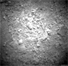

|
ADMIN NOTE: Post edited to remove inline image. Refer to http://www.unmannedspaceflight.com/index.php?act=boardrules on Posting Etiquette 3.2
Posted by: kenny Oct 19 2012, 10:08 PM
The Martian Glenelg was named with the Canadian one in mind, certainly, but that in turn was named after the original Scottish one. Scottish Glenelg is of considerable geologic interest, sitting on the Moine Thrust plane, and with three geologic units around it.
http://marsmobile.jpl.nasa.gov/blogs/index.cfm?FuseAction=ShowBlogs&BlogsID=246&BlogsTagName=jeffrey%20marlow
" The title Glenelg was chosen on the strength of two characteristics. Glenelg is the name of a geological unit near Yellowknife, Canada, and as science team member Dawn Sumner notes, Yellowknife is the name we chose for this map quad, and the features in the quad are named after features associated with Yellowknife.
The words palindromic nature its the same spelled forward and backward also played a key role, since Curiosity plans to visit the site and then retrace its treads on the way toward Mount Sharp. You know, just a little mission architecture humor.
But the full etymology of Glenelg goes back several centuries, to a remote, windswept peninsula in western Scotland. "
Posted by: Ondaweb Oct 20 2012, 01:11 AM
Is the black bell shaped "popcorn" a picture of the plasma generated by the laser or the hole left? And any idea why some pebbles at the bottom left quadrant appear to move?
Posted by: nprev Oct 20 2012, 01:15 AM
Looks like the "bell" shape is the hole itself. And there sure seems to have been a vapor/plasma outflow towards the bottom of the image energetic enough to blow around a few 'pebbles' (though I'm not sure how large they are; probably too small for us to think of as pebbles, really).
Posted by: centsworth_II Oct 20 2012, 01:35 AM
Posted by: CosmicRocker Oct 20 2012, 05:32 AM
However, I find it intriguing to note that polygonal fractures/features at several scales have been observed in the sediments of Gale Crater. Large scale polygons (and boxwork) have been imaged from orbit, we have seen medium scale polygons on the distant foothills of Mt. Sharp in some long range mastcam images, and now we've seen several examples of small scale polygons in some near range mastcam images. It's tempting to speculate that this entire range of polygonal structure or fabric may be genetically related.
Posted by: jmknapp Oct 20 2012, 11:07 AM
As far as that goes, mud cracks are a classic example of a fractal pattern with similarity on multiple levels.
I think this is the area referred to in the GSA paper, a few hundred meters north of the landing site:
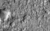
|
Here's the location in relation to the landing site and Glenelg:
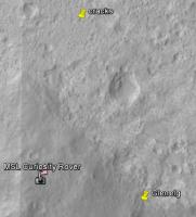
|
Never too soon for reasoned guesses...
Posted by: eoincampbell Oct 20 2012, 06:42 PM
http://photojournal.jpl.nasa.gov/jpeg/PIA16200.jpg too ? We can take a close look, can't wait...
Posted by: climber Oct 20 2012, 06:48 PM
Yep! Would be great if somebody could draw the path as seen from the ground
Posted by: ronald Oct 20 2012, 09:08 PM
Fun with MAHLI - sol 73:

|
Interesting image:

|
Wheel abrasion, micro-ripples, strange dark stone, some color shift to the edges (?)
Posted by: ngunn Oct 20 2012, 11:28 PM
Replying to eoincampbell: Where is that proposed track from? Posting the source would be nice.
Posted by: Phil Stooke Oct 20 2012, 11:39 PM
ngunn, it's on the JPL Curiosity website among the press release images.
Phil
Posted by: climber Oct 20 2012, 11:40 PM
From the telecom since a while...
Edited: oups, Phil beat me by half a second.
Posted by: CosmicRocker Oct 21 2012, 05:37 AM
The planned routes that I have seen for Curiosity's explorations show her in the vicinity of the polygonal ridges somewhere between sols 700 and 800. That may be optimistic, but it is clear that it will be a long time before we may get to see these ridges from the ground. Among the amazing images this rover will eventually return to earth, those of the polygonal ridges may challenge those of the canyons and precipices we expect to see as some of the most astounding extraplanetary visions our exploratory robots will capture from one of the inner planets.
To be fair, that may be a bit of an exaggeration, but I can't help but wonder what this rover will look like from orbit as she approaches these features. In the attached image I have grabbed a HiRISE image of some of the more impressive, large-scale boxwork structures at full scale and overlayed a blue ellipse at roughly the same scale to represent the rover, were she to venture into this vicinity.

|
Posted by: jvandriel Oct 21 2012, 09:42 AM
The complete Sol 64-66 MastCam R Panoramic view.
Jan van Driel
|
|
Posted by: Jam Butty Oct 21 2012, 10:56 AM
Scoop #4,
Sol 74 anaglyph...

|
Posted by: Stu Oct 21 2012, 09:48 PM
Love those low Sun views...

|
Posted by: fredk Oct 21 2012, 10:20 PM
At the press conference this week, they commented on http://mars.jpl.nasa.gov/msl-raw-images/msss/00070/mcam/0070ML0425000000E1_DXXX.jpg They said there were two components that came from the material added to the tray - the larger, dark grains, and an extremely fine, very bright powder. At the time I thought that sounded odd - where's the evidence for a very bright, fine component on the ground or in the trenches? The fine Martian dust that covers almost everything is much darker than the white streak on the tray, as you can see in that image I linked to above.
But now looking at the sol 73 mahli images, eg http://mars.jpl.nasa.gov/msl-raw-images/msss/00073/mhli/0073MH0086001001C0_DXXX.jpg it looks to me like it's the other way around: most of the tray is covered in fine dust, except in the bright streak (the bright streak does have the larger particles, of course). The fine dust is darker than the tray. They said that the particles were blown into the streak pattern by wind - I'm suggesting that it was the scouring action of the grains blowing across the tray that cleared the fine dust from the streak. (The "bright streak" looks dark in this mahli frame, but that could just be due to different lighting.)
Posted by: jmknapp Oct 22 2012, 11:04 AM
The way I heard it, it's not any material that's bright, it's just the shiny surface of the tray. You can particularly see in this picture that the tray is covered with fine red dust except in that area:
http://mars.jpl.nasa.gov/msl-raw-images/msss/00073/mhli/0073MH0085001000E1_DXXX.jpg
Granted, there were three sols between that and the other image:
http://mars.jpl.nasa.gov/msl-raw-images/msss/00070/mcam/0070ML0425000000E1_DXXX.jpg
...and the bright area does seem to have some texture in the earlier picture.
Posted by: Actionman Oct 22 2012, 03:15 PM
Could have been a cloud crossing overhead at the time of the ML photo. But not blocking the sun.
Posted by: ronald Oct 23 2012, 07:39 AM
Partial Mastcam 100 panSol 70 and 72:
|
|
http://dl.dropbox.com/u/5875127/msl/0070%2B0072_L.jpg Unfortunately allways the center images between two chunks are missing ...
I wonder if the sol 67 pan will fit in somewhere (64+66+67?).
And a small one:

|
Posted by: Ant103 Oct 23 2012, 06:28 PM
Hi guys,
I was enduring some serious problems this last week, but I've found a solution I hope.
So, I took the time to finish the HUGE Sol 64 & 66 Mastcam100. This is just insane .
http://www.db-prods.net/marsroversimages/curiosity.html#62
Posted by: Paul Fjeld Oct 23 2012, 06:56 PM
Ça me fait capoter!
(trans: "this blows my mind")
Posted by: ronald Oct 23 2012, 07:04 PM
Nice work Ant! I'm pretty sure that sol 67 pan http://dl.dropbox.com/u/5875127/msl/64_66_67.jpg to the left side!
To not post too much redundant stuff I focused somewhat more on the dark side - sol 67 M100:
http://dl.dropbox.com/u/5875127/msl/0067MR0484000000E1_DXXX-0067MR0484047000E1_DXXX_M.jpg http://dl.dropbox.com/u/5875127/msl/0067MR0484000000E1_DXXX-0067MR0484047000E1_DXXX_XL.jpg
Enjoy!
Posted by: Reed Oct 23 2012, 07:51 PM
A tiny natural bridge. From sol 71 chemcam
before http://mars.jpl.nasa.gov/msl/multimedia/raw/?rawid=CR0_403793226EDR_F0050104CCAM02071M_&s=71
after http://mars.jpl.nasa.gov/msl/multimedia/raw/?rawid=CR0_403794269EDR_F0050104CCAM02071M_&s=71
Sol 72 Mastcam 100 of the same area http://mars.jpl.nasa.gov/msl/multimedia/raw/?rawid=0072MR0557000000E1_DXXX&s=72 clearly showing the chemcam hits.
edit and a Mastcam 34 from Sol 66 http://mars.jpl.nasa.gov/msl/multimedia/raw/?rawid=0066ML0296030000E2_DXXX&s=66
Posted by: vikingmars Oct 24 2012, 08:42 AM
Sol 67 afternoon view with Sol 50 mountains added as background at the same scale
(a view much reduced in size to fill in the Forum...).
Enjoy !

|
Posted by: Phil Stooke Oct 24 2012, 12:37 PM
Nice one, Olivier!
Here is an update on activities at Rocknest. Crestaurum is the location of the ChemCam observation animated in the recent JPL release. These are oriented with north at (or very near) the top, as always in my maps.
Phil

|
EDIT - thanks to Greenish for pointing out I had reversed scoops 3 and 4. I have now corrected that and replaced the image with the good one.
Posted by: Stu Oct 24 2012, 02:28 PM
Loving the rocks Curiosity is seeing now...
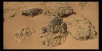
|
Posted by: algorimancer Oct 24 2012, 03:27 PM
These look an awful lot like basalt to me. I really wasn't expecting that here. Except there appears to be a chunk of something like slate embedded a bit below center of the large dark rock in the center. The dusty rock above it also seems to have a vaguely sedimentary inclusion, though it could as easily be a mineral-filled crack.
Posted by: fredk Oct 24 2012, 03:35 PM
Thanks for pointing that out. Here are ML/R anaglyph and side-by-side stereo views:

|

|
The lighting is very different, but you get the idea.
Posted by: dvandorn Oct 24 2012, 05:16 PM
Yep -- lots of interesting contacts and inclusions in some of these rocks. The one that really stood out to my eye, though, is the rock in the upper left of the imaged grouping:

|
It's a touch difficult to see because the upper unit is the same color as the soil behind it, but there is definitely a very bright light-toned, reddish unit forming a layer at the top of this rock. It doesn't look like a preferential dust coating, the contact is quite regular, even giving the appearance of the light-toned unit filling voids in the top of the dark basaltic-looking unit, as if it was emplaced in a fluid manner. Also, the light-toned unit is eroding more quickly than the lower dark-toned unit.
If I had to guess, this could be the result of a flow of mud or sediment that covered over a layer of basalt, and the mud or sediment has since lithified. You have to wonder, though, what exhumed this particular chunk to leave this contact above-ground? Are we looking at evidence of the deflation of fill material from the Gale floor?
-the other Doug
Posted by: fredk Oct 24 2012, 05:26 PM
What makes you say it's not just a dust coating? Most of the horizontalish surfaces around here have the ubiquitous dust coating, which matches the colour of the surrounding soil because it also coats the soil.
Posted by: dvandorn Oct 24 2012, 06:19 PM
Well -- if it is a dust coating, the dust is preferentially coating just the upper unit above the visible contact, which is definitely eroding more quickly than the dark-toned basaltic rock below the contact. This dark-toned rock is dust coated in some places, but even where dust-coated the dark-toned unit looks darker than this light-toned upper unit.
The upper unit also shows a fairly consistent coloring, with slight hints of a light gray showing through, indicating a dust coating over all surfaces, while the darker-toned unit shows dust coatings only in those places where wind erosion has not stripped it off. In particular, the dark-toned surfaces just below the contact have generally not been dust coated, while the light-toned unit above the contact is either dust coated or actually is composed of material of a light reddish color.
There are also very distinct textural differences between the units above and below the contact, including but not limited to the greater wind erosion seen in the upper unit as compared to the lower unit. This definitely speaks to this being an actual contact between rocks of different composition.
-the other Doug
Posted by: EdTruthan Oct 25 2012, 01:27 AM
Wow, with the additional batch of Sol 74 MC100's down today the "Low Sun Angle" mosaic is growing huge, up to almost 27,000 pixels wide now. This latest batch stitches right up to the left side nicely. Here's the whole shebang in it's gloriously rich raw color at 27000 x 3550px (and 34MB!)...
http://www.edtruthan.com/mars/Sol70-72-74-MC100-Low-Sun-Angle-Mosaic.jpg
Posted by: serpens Oct 25 2012, 02:17 AM
Yeah, looks like a breccia and after all Mars is a basaltic environment. It will be interesting to see just how widespread this is. I mean, are we seeing a suevite layer from the original crater or is this ejecta from a separate impact? I'm with fredk as the pale layer looks like dust.
Posted by: jvandriel Oct 25 2012, 03:40 PM
Here is the MASTCam R Panoramic view taken on
Sol 67-70-72-74.
136 images and the original size is 104 MB.
Jan van Driel
|
|
Posted by: Actionman Oct 25 2012, 04:32 PM
Well isn't that just it then, the dust is ubiquitous and THEN it isn't at some point. Some rocks have and some rocks not somuch.
Fact is Mars is not all one color.
Posted by: Floyd Oct 25 2012, 05:01 PM
I think the other Doug's hypothesis is that there are two rock types with a contact and the look is not due to partial dust coverage as Fredk suggests. I favor Doug's hypothesis, but is probably impossible to resolve with just the visual image--it could be resolved if that rock, or a rock with a similar "contact" was brushed or zapped in a pattern crossing the contact...
Powered by Invision Power Board (http://www.invisionboard.com)
© Invision Power Services (http://www.invisionpower.com)