MSL landing site: Gale Crater |

  |
MSL landing site: Gale Crater |
 Aug 4 2012, 07:39 PM Aug 4 2012, 07:39 PM
Post
#331
|
|
 Member  Group: Members Posts: 754 Joined: 9-February 07 Member No.: 1700 |
That's really cool! <- I've probably said that in about 30% of my posts on UMSF!

|
 |
 
|
|
Aug 4 2012, 09:14 PM
Post
#332
|
|
 The Poet Dude Group: Moderator Posts: 5551 Joined: 15-March 04 From: Kendal, Cumbria, UK Member No.: 60 |
QUOTE (Tesheiner @ Aug 4 2012, 06:38 PM)  I have temporarily hosted the map at Dropbox. Here's the KML file to access it. Oh *wow*... what a treat to come home to... fanTASTIC, thank you! -------------------- |
|
|
|
|
Aug 4 2012, 09:25 PM
Post
#333
|
|
|
Senior Member Group: Members Posts: 2918 Joined: 14-February 06 From: Very close to the Pyrénées Mountains (France) Member No.: 682 |
I'd say we're ready from our end!

-------------------- |
|
|
|
|
Aug 4 2012, 09:42 PM
Post
#334
|
|
|
Member Group: Members Posts: 154 Joined: 21-April 05 From: Rochester, New York, USA Member No.: 336 |
QUOTE (Stu @ Aug 4 2012, 05:14 PM) Oh *wow*... what a treat to come home to... fanTASTIC, thank you! Indeed! |
|
|
|
|
Aug 5 2012, 12:55 AM
Post
#335
|
|||
 Senior Member Group: Members Posts: 1465 Joined: 9-February 04 From: Columbus OH USA Member No.: 13 |
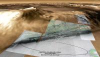
Here's a view of the planned traverse of MSL (first 20 km or so) according to a reference I found online:
Another angle:
-------------------- |
||
|
|
|
||
|
Aug 5 2012, 05:52 AM
Post
#336
|
|
 Chief Assistant Group: Admin Posts: 1409 Joined: 5-January 05 From: Ierapetra, Greece Member No.: 136 |
QUOTE (Tesheiner @ Aug 4 2012, 07:38 PM) I have temporarily hosted the map at Dropbox. Here's the KML file to access it. Awesome work! Is there any way to overlap the rest of Gale with the Mars Express Imagery? -------------------- photographer, space imagery enthusiast, proud father and partner, and geek.
http://500px.com/sacred-photons & |
|
|
|
|
Aug 5 2012, 06:18 AM
Post
#337
|
||
 Member Group: Members Posts: 404 Joined: 5-January 10 Member No.: 5161 |
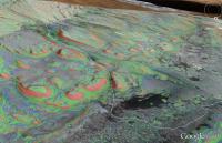
QUOTE (jmknapp @ Aug 4 2012, 04:55 PM) Here's a view of the planned traverse of MSL (first 20 km or so) according to a reference I found online: Here's a rough-looking section of that route, right up the canyon! I put in a very crude possible path for the rover. The hour draws near!
|
|
|
|
|
|
|
Aug 5 2012, 07:56 AM
Post
#338
|
|
|
Senior Member Group: Moderator Posts: 4279 Joined: 19-April 05 From: .br at .es Member No.: 253 |
QUOTE (jmknapp @ Aug 5 2012, 02:55 AM) Here's a view of the planned traverse of MSL (first 20 km or so) according to a reference I found online: That canyon looks promising and the views might just be great! Can you post a link to that reference, Joe? QUOTE (Nix @ Aug 5 2012, 07:52 AM) Awesome work! Is there any way to overlap the rest of Gale with the Mars Express Imagery? Probably yes. Although I think it might be difficult to match the overlay with the MOLA background. |
|
|
|
|
Aug 5 2012, 09:46 AM
Post
#339
|
|
|
Senior Member Group: Members Posts: 1465 Joined: 9-February 04 From: Columbus OH USA Member No.: 13 |
QUOTE (Tesheiner @ Aug 5 2012, 02:56 AM) That canyon looks promising and the views might just be great! Can you post a link to that reference, Joe? MSL Landing Sites: Gale, Reconsidered (PDF) -- Edgett, Milliken, Grotzinger, Malin The "notional" track I used is on p. 14. -------------------- |
|
|
|
|
Aug 5 2012, 11:13 AM
Post
#340
|
|
|
The Poet Dude Group: Moderator Posts: 5551 Joined: 15-March 04 From: Kendal, Cumbria, UK Member No.: 60 |
QUOTE (walfy @ Aug 5 2012, 07:18 AM) Here's a rough-looking section of that route, right up the canyon! I put in a very crude possible path for the rover. The hour draws near! A martian Monument Valley, right there... might be years until we get there, but boy, the views we'll have...  -------------------- |
|
|
|
|
Aug 5 2012, 05:36 PM
Post
#341
|
|
|
Merciless Robot Group: Admin Posts: 8783 Joined: 8-December 05 From: Los Angeles Member No.: 602 |
I too am looking forward to some incredible canyon views...
One question, though: Is there a set of constraints for entering them related to comm? Presumably you'd never want MSL to get into a situation where line-of-sight with the orbiters during their passes was too brief to be useful; in all likelihood, the DTE antenna would be blocked most of the time as well. -------------------- A few will take this knowledge and use this power of a dream realized as a force for change, an impetus for further discovery to make less ancient dreams real.
|
|
|
|
|
Aug 5 2012, 05:51 PM
Post
#342
|
|
 Senior Member Group: Members Posts: 4246 Joined: 17-January 05 Member No.: 152 |
I don't know if any potential MSL route takes them into areas with much more of the sky blocked than we had in the Columbia Hills or inside Endurance or Victoria. Maybe that's the case, but I'd have to check with the great slope maps we have now. The anaglyphs look dramatic but they can give an exagerated sense of depth.
I vaguely remember communications being affected to some extent inside Victoria, but I could be wrong... |
|
|
|
|
Aug 5 2012, 06:50 PM
Post
#343
|
|
|
Member Group: Admin Posts: 976 Joined: 29-September 06 From: Pasadena, CA - USA Member No.: 1200 |
The horizon as seen by MSL will be less than 20-25 deg from horizontal so we might have a shorter UHF pass but I don't think we will be limited in comm.
Paolo -------------------- Disclaimer: all opinions, ideas and information included here are my own,and should not be intended to represent opinion or policy of my employer.
|
|
|
|
|
Aug 5 2012, 10:34 PM
Post
#344
|
||||
|
The Poet Dude Group: Moderator Posts: 5551 Joined: 15-March 04 From: Kendal, Cumbria, UK Member No.: 60 |
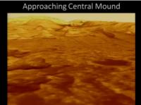
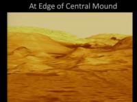
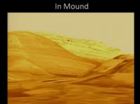
Some fascinating screengrabs from the Planetary Society event currently being broadcast on livestream... these slides were shown by Matt Golombeck - simulated views of what MSL will see if it approaches and then reaches "The Mound". He said these are all 1:1, no stretching...
Oh my...  Matt also went to great paisn to say that MSL *won't* climb to the summit of Mt Sharp because the material higher up was too "light and fluffy". -------------------- |
|||
|
|
|
|||
|
Aug 5 2012, 11:05 PM
Post
#345
|
|
|
Senior Member Group: Members Posts: 2079 Joined: 13-February 10 From: Ontario Member No.: 5221 |
I heard some similar talk about Husband Hill, and Victoria.... and Endeavor... we'll wait and see, eh?
(not saying Matt is wrong, I just think it's too early to predict what the rover will be able to do). |
|
|
|
|

|
Lo-Fi Version | Time is now: 19th April 2024 - 02:35 AM |
|
RULES AND GUIDELINES Please read the Forum Rules and Guidelines before posting. IMAGE COPYRIGHT |
OPINIONS AND MODERATION Opinions expressed on UnmannedSpaceflight.com are those of the individual posters and do not necessarily reflect the opinions of UnmannedSpaceflight.com or The Planetary Society. The all-volunteer UnmannedSpaceflight.com moderation team is wholly independent of The Planetary Society. The Planetary Society has no influence over decisions made by the UnmannedSpaceflight.com moderators. |
SUPPORT THE FORUM Unmannedspaceflight.com is funded by the Planetary Society. Please consider supporting our work and many other projects by donating to the Society or becoming a member. |
|