Enceladus 3d |

 Unmanned Spaceflight.com > Outer Solar System > Saturn > Cassini Huygens > Cassini's ongoing mission and raw images
  |
Enceladus 3d |
 Jul 22 2005, 05:53 PM Jul 22 2005, 05:53 PM
Post
#1
|
||||
|
Junior Member  Group: Members Posts: 61 Joined: 5-June 05 From: 46.283N 11.433E :)) Member No.: 401 |
Hi,
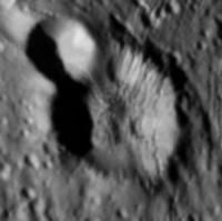
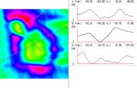
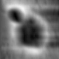
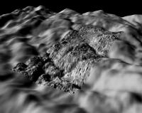
I'm always been a lurker here.  This is a great forum! Thanx to all! This is a great forum! Thanx to all!  I've written a small script in Python that extract the elevation map from an image with lights and shadows. It's a technic called "shape from shading" or photoclinometry. I've applied a simplified algorythm that works only with particular conditions. For example light must come exactly from left to right. It works well only with no patterned images and output images are affected by a boring striped pattern.  Btw, I've worked on an Enceladus crater an this is the result. 3D rendering is by GRASS software. In attachments there are the image of the crater, the 3D image and a map with profiles. ale
|
|||
 |
 
|
|||
|
Jul 22 2005, 06:03 PM
Post
#2
|
|
|
Junior Member Group: Members Posts: 61 Joined: 5-June 05 From: 46.283N 11.433E :)) Member No.: 401 |
I was forgetting a BIG thanx to slinted that had fixed some bugs in the script!!!
|
|
|
|
|
Jul 22 2005, 06:28 PM
Post
#3
|
|||
 Senior Member Group: Members Posts: 2530 Joined: 20-April 05 Member No.: 321 |
QUOTE (malgar @ Jul 22 2005, 10:53 AM) Hi, I'm always been a lurker here. This is a great forum! Thanx to all! I've written a small script in Python that extract the elevation map from an image with lights and shadows. It's a technic called "shape from shading" or photoclinometry. I've applied a simplified algorythm that works only with particular conditions. For example light must come exactly from left to right. It works well only with no patterned images and output images are affected by a boring striped pattern. Btw, I've worked on an Enceladus crater an this is the result. 3D rendering is by GRASS software. In attachments there are the image of the crater and the 3D image. ale
 Fantastic stuff -- is it possible to rotate the highest resolution image (with boulders) and run the script on that? Any such product could be downsampled and still have great resolution -- could be used to produce a synthetic image of a horizon-looking panorama as seen from the surface. What could be cooler than that? |
||
|
|
|
||
|
Jul 22 2005, 07:47 PM
Post
#4
|
|||
|
Junior Member Group: Members Posts: 61 Joined: 5-June 05 From: 46.283N 11.433E :)) Member No.: 401 |
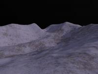
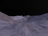
QUOTE (JRehling @ Jul 22 2005, 08:28 PM) produce a synthetic image of a horizon-looking panorama as seen from the surface. What could be cooler than that? Like these? (Terragen power!!) 
|
||
|
|
|
||
|
Jul 22 2005, 08:19 PM
Post
#5
|
|
 IMG to PNG GOD Group: Moderator Posts: 2250 Joined: 19-February 04 From: Near fire and ice Member No.: 38 |
This is absolutely fantastic, I'm especially impressed by the fact that (horizontal) stripes are not obvious. Is a description of the algorithm you are using available somewhere ? Also it would be very interesting to see a 16 bit grayscale version of the DEM instead of the color version in enceladus_profiles.png so I could try rendering this myself ;-).
I have from time to time been experimenting with something similar: http://www.mmedia.is/bjj/data/mimas/mimas.html (this is a Voyager-based map with no Cassini data). However, horizontal stripes have been an extremely annoying problem. |
|
|
|
|
Jul 22 2005, 08:46 PM
Post
#6
|
||
|
Junior Member Group: Members Posts: 61 Joined: 5-June 05 From: 46.283N 11.433E :)) Member No.: 401 |
QUOTE (Bjorn Jonsson @ Jul 22 2005, 10:19 PM) This is absolutely fantastic, I'm especially impressed by the fact that (horizontal) stripes are not obvious. Is a description of the algorithm you are using available somewhere ? Hi, in the next days I'll release the whole script (it is only few rows of code), now it is too raw.. I have to "polish" it a bit. Clearly this is not a my idea. I've caught this page in french http://www.astrosurf.com/rondi/lune3d.htm, and I've tried to reproduce the algorithm. In truth, it is a "simple" integration row by row of brightness. How is your algorithm? QUOTE Also it would be very interesting to see a 16 bit grayscale version of the DEM instead of the color version in enceladus_profiles.png so I could try rendering this myself ;-). For sure! Look at here:
QUOTE I have from time to time been experimenting with something similar: http://www.mmedia.is/bjj/data/mimas/mimas.html (this is a Voyager-based ma with no Cassini data). Wooow! great job! QUOTE However, horizontal stripes have been an extremely annoying problem. I think that horizontal stripes come from a bad alignament of sunlight. If it is, with a great precision, from left to right, stripes are minimal. When you integrate the row and you "sum" a bright pixel, there will be a string of pixel with high values, untill you reach a dark pixel that subtract values. If light is not well aligned, the integration will never find the dark pixel, and it will become a bright horizontal stripe. |
|
|
|
|
|
|
Jul 24 2005, 02:46 AM
Post
#7
|
|||
|
Senior Member Group: Members Posts: 2530 Joined: 20-April 05 Member No.: 321 |
QUOTE (malgar @ Jul 22 2005, 12:47 PM) Like these? (Terragen power!!)
Definitely fabulous -- can it be done with the highest resolution image from this last flyby? |
||
|
|
|
||
|
Mar 27 2008, 02:07 PM
Post
#8
|
||
 Member Group: Members Posts: 207 Joined: 6-March 07 From: houston, texas Member No.: 1828 |
Hi guys,
nice work! Ive finally posted several of my own 3d rendered perspectives of Enceladus on Photojournal (got buried under the Plume PCon release pix). one view is attached. Hope to release some more of this and other moons in the coming weeks. Enjoy paul
Attached thumbnail(s)
-------------------- Dr. Paul Schenk, Lunar and Planetary Institute, Houston TX
http://stereomoons.blogspot.com; http://www.youtube.com/galsat400; http://www.lpi.usra.edu/science/schenk/ |
|
|
|
|
|
|
Mar 27 2008, 02:30 PM
Post
#9
|
|
 Senior Member Group: Members Posts: 3648 Joined: 1-October 05 From: Croatia Member No.: 523 |
QUOTE (DrShank @ Mar 27 2008, 03:07 PM) Ive finally posted several of my own 3d rendered perspectives of Enceladus on Photojournal Nice. Do I see it correctly that only the WAC frame was used for photoclinometry, while the motion-blurred NAC frame was useless for the purpose? -------------------- |
|
|
|
|
Mar 27 2008, 02:41 PM
Post
#10
|
|
|
Member Group: Members Posts: 207 Joined: 6-March 07 From: houston, texas Member No.: 1828 |
QUOTE (ugordan @ Mar 27 2008, 09:30 AM) Nice. Do I see it correctly that only the WAC frame was used for photoclinometry, while the motion-blurred NAC frame was useless for the purpose? Both frames have pc applied to them, and they were merged after the fact. given the nature of PC its the best way to do it. paul -------------------- Dr. Paul Schenk, Lunar and Planetary Institute, Houston TX
http://stereomoons.blogspot.com; http://www.youtube.com/galsat400; http://www.lpi.usra.edu/science/schenk/ |
|
|
|
|
Mar 27 2008, 04:14 PM
Post
#11
|
|
 Administrator Group: Admin Posts: 5172 Joined: 4-August 05 From: Pasadena, CA, USA, Earth Member No.: 454 |
Neato, Paul! Would you happen to have anaglyphs?
--Emily -------------------- My website - My Patreon - @elakdawalla on Twitter - Please support unmannedspaceflight.com by donating here.
|
|
|
|
|
Mar 27 2008, 04:33 PM
Post
#12
|
|
|
Member Group: Members Posts: 207 Joined: 6-March 07 From: houston, texas Member No.: 1828 |
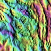
QUOTE (elakdawalla @ Mar 27 2008, 10:14 AM) Neato, Paul! Would you happen to have anaglyphs? --Emily dang, its not stereo in this specific example. I could create a synthetic stereo image from the topo map tho not for a bit cause of the things on my plate right now. I attach the color coded topo map from a vertical perspective (reduced by 50%), which i may post online later as well. cheers paul -------------------- Dr. Paul Schenk, Lunar and Planetary Institute, Houston TX
http://stereomoons.blogspot.com; http://www.youtube.com/galsat400; http://www.lpi.usra.edu/science/schenk/ |
|
|
|
|
Mar 27 2008, 04:42 PM
Post
#13
|
||
|
Member Group: Members Posts: 207 Joined: 6-March 07 From: houston, texas Member No.: 1828 |
QUOTE (elakdawalla @ Mar 27 2008, 10:14 AM) Neato, Paul! Would you happen to have anaglyphs? --Emily dang, its not stereo in this specific example. I could create a synthetic stereo image from the topo map tho not for a bit cause of the things on my plate right now. I attach the color coded topo map of this scene from a vertical perspective (reduced by 50%), which i may post online later as well. cheers paul
Attached thumbnail(s)
-------------------- Dr. Paul Schenk, Lunar and Planetary Institute, Houston TX
http://stereomoons.blogspot.com; http://www.youtube.com/galsat400; http://www.lpi.usra.edu/science/schenk/ |
|
|
|
|
|
|
Mar 27 2008, 11:50 PM
Post
#14
|
||||
|
IMG to PNG GOD Group: Moderator Posts: 2250 Joined: 19-February 04 From: Near fire and ice Member No.: 38 |
This looks fantastic. If it's not asking too much there are some people here who would love to have grayscale versions showing only the DEM and and not a color coded DEM/image combination
 . This makes it easy to generate custom 3D renders. . This makes it easy to generate custom 3D renders.Back to the original topic - this is a DEM I generated from a stereo pair:
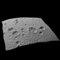
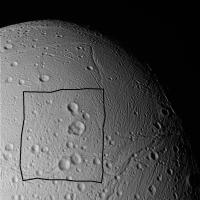
The altitude range is ~4.5 km. This is work in progress and is a relatively low quality DEM. In particular the quality is rather low compared to the Iapetus DEM I have mentioned in other threads here. This is mainly because Iapetus' high contrast and albedo variations make it easier for my stereo matcher to find matching features in the image pairs. What I find interesting is how extensive the raised 'rims' surrounding the craters are. Their width typically seems to be ~50% or more of the crater diameter. And for fun, this is a 3D render with vertical relief exaggerated by a factor of 3:
This is the area covered by the DEM:
|
|||
|
|
|
|||
|

|
Lo-Fi Version | Time is now: 20th April 2024 - 03:30 AM |
|
RULES AND GUIDELINES Please read the Forum Rules and Guidelines before posting. IMAGE COPYRIGHT |
OPINIONS AND MODERATION Opinions expressed on UnmannedSpaceflight.com are those of the individual posters and do not necessarily reflect the opinions of UnmannedSpaceflight.com or The Planetary Society. The all-volunteer UnmannedSpaceflight.com moderation team is wholly independent of The Planetary Society. The Planetary Society has no influence over decisions made by the UnmannedSpaceflight.com moderators. |
SUPPORT THE FORUM Unmannedspaceflight.com is funded by the Planetary Society. Please consider supporting our work and many other projects by donating to the Society or becoming a member. |
|