LROC news and images |

  |
LROC news and images |
 Aug 19 2009, 02:24 AM Aug 19 2009, 02:24 AM
Post
#121
|
|
 Senior Member  Group: Admin Posts: 4763 Joined: 15-March 05 From: Glendale, AZ Member No.: 197 |
QUOTE (Phil Stooke @ Aug 16 2009, 05:12 AM)  what would Perez Hilton call Keith Cowing? You don't want to know what I would call him. -------------------- If Occam had heard my theory, things would be very different now.
|
 |
 
|
|
Aug 19 2009, 03:57 AM
Post
#122
|
|
 Administrator Group: Admin Posts: 5172 Joined: 4-August 05 From: Pasadena, CA, USA, Earth Member No.: 454 |
QUOTE (Phil Stooke @ Aug 18 2009, 07:01 PM) ... and as if by magic, a new LROC image appears - lovely view of a sinuous rille on the Aristarchus Plateau. Thanks for the tip, Phil!Is anybody else having trouble getting the Zoomify version to load? --Emily -------------------- My website - My Patreon - @elakdawalla on Twitter - Please support unmannedspaceflight.com by donating here.
|
|
|
|
|
Aug 19 2009, 05:01 AM
Post
#123
|
||
 Senior Member Group: Members Posts: 3419 Joined: 9-February 04 From: Minneapolis, MN, USA Member No.: 15 |
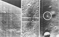
QUOTE (Hungry4info @ Aug 15 2009, 07:55 AM) Is this the image you refer to? (from LO3). Surveyor Programme Results (down there on what it considers page 8) Yep, that's the one -- I see that Surveyor I was actually imaged by LO1 and LO3, with the LO3 picture the better of the two. I remember the image from the classic "Exploring Space with a Camera" by Edgar Cortwright. Here's the image I recall, a three-shot zooming in on the SI site:
Many of my early Surveyor image memories come from this book. -the other Doug -------------------- The trouble ain't that there is too many fools, but that the lightning ain't distributed right. -Mark Twain
|
|
|
|
|
|
| Guest_Zvezdichko_* |
Aug 19 2009, 07:11 AM
Post
#124
|
||
|
Guests |
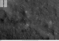
QUOTE (elakdawalla @ Aug 19 2009, 03:57 AM) Is anybody else having trouble getting the Zoomify version to load? --Emily Yes - me... Actually, I succeeded in cropping two frames from the big image. Here they are:
Attached thumbnail(s)
|
||
|
|
|
||
|
Aug 19 2009, 11:37 AM
Post
#125
|
|
|
Solar System Cartographer Group: Members Posts: 10153 Joined: 5-April 05 From: Canada Member No.: 227 |
I couldn't get it last night but I can now.
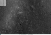
There are some nice rolling rock trails on the walls of the main valley, both north and south sides. I'm also struck by how smooth the surface looks compared with typical mare surfaces. This is a place that would be easy to land on. Phil -------------------- ... because the Solar System ain't gonna map itself.
Also to be found posting similar content on https://mastodon.social/@PhilStooke Maps for download (free PD: https://upload.wikimedia.org/wikipedia/comm...Cartography.pdf NOTE: everything created by me which I post on UMSF is considered to be in the public domain (NOT CC, public domain) |
|
|
|
|
Aug 19 2009, 02:52 PM
Post
#126
|
|
|
Member Group: Members Posts: 156 Joined: 22-May 09 From: Ireland Member No.: 4792 |
QUOTE (Phil Stooke @ Aug 19 2009, 12:37 PM) "...some nice rolling rock trails..." Had collaged together an image about these trails on Chuck's LPOD this morning check it out John ------------- A Moon Site |
|
|
|
|
Aug 19 2009, 03:56 PM
Post
#127
|
||
|
Junior Member Group: Members Posts: 62 Joined: 30-July 09 Member No.: 4887 |
QUOTE (Phil Stooke @ Aug 19 2009, 11:37 AM) I couldn't get it last night but I can now. There are some nice rolling rock trails on the walls of the main valley, both north and south sides. I'm also struck by how smooth the surface looks compared with typical mare surfaces. This is a place that would be easy to land on. Phil Yes, some nice ones. Here is what I found.
|
|
|
|
|
|
|
Aug 19 2009, 06:29 PM
Post
#128
|
|
|
Senior Member Group: Members Posts: 1074 Joined: 21-September 07 From: Québec, Canada Member No.: 3908 |
Nice trails. We're starting to see the Moon like never before.
I find it difficult to evaluate the size of the blocks. The LROC image browser lacks a scale bar. Even if the pixel size is mentioned, I don't find it very useful. I suppose I could download the TIFF files and count the pixels, but they are large files. Sometimes with Photoshop (version 7) I could not open them. |
|
|
|
|
Aug 19 2009, 07:20 PM
Post
#129
|
|
|
Junior Member Group: Members Posts: 62 Joined: 30-July 09 Member No.: 4887 |
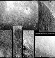
QUOTE (charborob @ Aug 19 2009, 06:29 PM) Nice trails. We're starting to see the Moon like never before. I find it difficult to evaluate the size of the blocks. The LROC image browser lacks a scale bar. Even if the pixel size is mentioned, I don't find it very useful. I suppose I could download the TIFF files and count the pixels, but they are large files. Sometimes with Photoshop (version 7) I could not open them. If you have the luxury to download the actual tifs, it can still be a bother to try to load them and view them. I use PCI Geometica Freeview Version 10.0 http://www.pcigeomatics.com/index.php?opti...7&Itemid=12 It is nice because it is free, can load 1 Gb files easily and has many different kinds of visual enhancement tools which the LROC image browser lacks/ makes it hard to resolve some features. I zoomed in by a factor of 2 the LRO image to capture my rolling boulder images and presented all images at the same scale (the LRO raw image is 1.46 m/pixel so if my images are viewed at 100%, then every two by two pixels is 1.46 m by 1.46 m). It is somewhat lossy due to jpeg storage economy. So, for my lower left image boulder (the largest), it is 16 by 21 magnified pixels which is 8 by 10.5 standard pixels or 12 m by 15 m. |
|
|
|
|
Aug 21 2009, 07:56 PM
Post
#130
|
|
|
Senior Member Group: Members Posts: 1074 Joined: 21-September 07 From: Québec, Canada Member No.: 3908 |
A new image on the LROC image browser: Necho crater. This looks like a really recent crater. Blocks, cracks everywhere.
http://wms.lroc.asu.edu/lroc_browse/view/M103703826LE |
|
|
|
|
Aug 21 2009, 09:50 PM
Post
#131
|
|
|
Member Group: Members Posts: 194 Joined: 8-February 04 Member No.: 10 |
'We have been so spoiled by the rapid release of MER and CASSINI images these past few years that we take it for granted, and sometimes expect too much of the people behind these missions.'
Is the release of raw JPEGS something we are 'spoiled' by or should it be regarded as standard PR outreach for missions that should be routinely done? Is there any plan to release quantities of raw jpegs of Lunar orbit images once the mapping orbit is finalized? Don |
|
|
|
|
Aug 21 2009, 10:52 PM
Post
#132
|
|
 The Poet Dude Group: Moderator Posts: 5551 Joined: 15-March 04 From: Kendal, Cumbria, UK Member No.: 60 |
QUOTE (DDAVIS @ Aug 21 2009, 10:50 PM) Is the release of raw JPEGS something we are 'spoiled' by or should it be regarded as standard PR outreach for missions that should be routinely done? Clearly the release of raw JPEGS is something we would all like to see for every mission, but over the years - thanks to the input of people here - I've... yes, possibly grudgingly... come to realise that that's not always practical/possible, for a Tardis-ful of reasons. It still sticks in my craw that ESA sits on images like a dragon hording gold, almost as if we "little people" wouldn't appreciate them, but I think that will change, in time, as the dinosaurs start dying out and are replaced by people who are as into this stuff as we are. It would be fantastic if it became routine, or even a requirement, for all umsf missions to let us see raw images asap, but in the real world that's not gonna happen. -------------------- |
|
|
|
|
Aug 22 2009, 12:48 AM
Post
#133
|
|
|
Solar System Cartographer Group: Members Posts: 10153 Joined: 5-April 05 From: Canada Member No.: 227 |
That Necho image is just about the most amazing yet. Emily wrote about bouncing rocks on her blog - well, check out the chains of pits - must have been bouncing! - at the southernmost part of the visible wall of Necho in this image. And the melt textures - really beautiful.
Phil -------------------- ... because the Solar System ain't gonna map itself.
Also to be found posting similar content on https://mastodon.social/@PhilStooke Maps for download (free PD: https://upload.wikimedia.org/wikipedia/comm...Cartography.pdf NOTE: everything created by me which I post on UMSF is considered to be in the public domain (NOT CC, public domain) |
|
|
|
|
Aug 22 2009, 01:30 AM
Post
#134
|
|
|
Senior Member Group: Members Posts: 3419 Joined: 9-February 04 From: Minneapolis, MN, USA Member No.: 15 |
Um, yeah -- my swear jar overfloweth!
The thing that strikes me, though, is that you could land a LM (or a Constellation lander) on the floor of that crater! There are lots of places that are flat and smooth enough for a vehicle to land. You'd have to be real careful where you walked and/or drove, but it could easily be done. And would be incredibly spectacular! And check out some of those rocks! There are rocks in there (and especially on the rim) that make House Rock look like a pebble! -the other Doug -------------------- The trouble ain't that there is too many fools, but that the lightning ain't distributed right. -Mark Twain
|
|
|
|
|
Aug 22 2009, 01:32 AM
Post
#135
|
|
|
Member Group: Members Posts: 194 Joined: 8-February 04 Member No.: 10 |
It would be fantastic if it became routine, or even a requirement, for all umsf missions to let us see raw images asap, but in the real world that's not gonna happen.
I hold American missions to a higher standard in PR outreach than ESA. How hard or expensive is it to release raw jpegs? If it is a matter of expense I certainly understand, if it is a matter of policy I do not. Don |
|
|
|
|

|
Lo-Fi Version | Time is now: 28th April 2024 - 08:52 PM |
|
RULES AND GUIDELINES Please read the Forum Rules and Guidelines before posting. IMAGE COPYRIGHT |
OPINIONS AND MODERATION Opinions expressed on UnmannedSpaceflight.com are those of the individual posters and do not necessarily reflect the opinions of UnmannedSpaceflight.com or The Planetary Society. The all-volunteer UnmannedSpaceflight.com moderation team is wholly independent of The Planetary Society. The Planetary Society has no influence over decisions made by the UnmannedSpaceflight.com moderators. |
SUPPORT THE FORUM Unmannedspaceflight.com is funded by the Planetary Society. Please consider supporting our work and many other projects by donating to the Society or becoming a member. |
|