Printable Version of Topic
Click here to view this topic in its original format
Unmanned Spaceflight.com _ Spirit _ Haskin Ridge
Posted by: stewjack Oct 6 2005, 05:59 AM
Now that we know where we are going, I thought we could use a topic about our future route. I hope that a few images will get the rover rolling - downhill.
 READY START
BACKGROUND
------
From Steve Squyres Misson Update
Octoberber 4, 2005
Extending eastward from the summit of Husband Hill is a broad ridge that we've named Haskin Ridge. It trends ENE from the summit, does a little dog-leg to the right, and then trends ESE for a bit. Right at the dog-leg there's a pretty steep step, which we're not certain we can get down. So we're going to descend the upper portion of the ridge, right to where the step is, and assess the situation. If we can see a safe route, then we'll continue down onto the lower portion of Haskin Ridge.
------
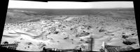
My Image of Haskin Ridge
I tried to get the best image of Haskin ridge that was available, and this is a crop from a true color TIFF summit panorama, located on the the Cornell Pancam web site. I converted the tif file to a gif file to save some download time. 
Warning : File Size : 1.7 MB 
http://web.newsguy.com/politicaleconomy/SOL-583-586-TrueColor-HASKIN-RIDGE.gif
Reference
WEB page of Husband Hill Summit Panorama
Warning: File Size : 80 MB !!!!
http://marswatch.astro.cornell.edu/pancam_instrument/husband_hill_summit.html
Jack
PS If you can't see the "steep step" that Squyres mentions - try this orbital image. I believe that the "steep step" is the dark shadow cutting across the ridge that is located directly under the word CRATER. I think that it is also visible in the true color pancam image, but it is less obvious.
http://marsrovers.jpl.nasa.gov/gallery/press/spirit/20040602a/08-JR-08-crater-A147R1.jpg
Posted by: jamescanvin Oct 6 2005, 06:28 AM
Good idea to get a new thread running for the decent.
http://marsrovers.jpl.nasa.gov/gallery/press/spirit/20040602a/08-JR-08-crater-A147R1.jpg

I'm not so sure you can see it in that (or any current) Pancam image (I'd love to be proved wrong).
In that Pancam image the nearest bit of the Haskin ridge visible is where it turns to the left a bit, this is visible in the orbital picture and is much further away than the steep step (holding pen upto monitor: about 300m). The step is less than 100m away and well hidden from the summit.
I'm sure one of our talented menbers will produce a image of what can and can't be seen from the 3D models. Hint

James
Posted by: jamescanvin Oct 6 2005, 06:59 AM
After re-reading your post I think we may be disagreeing on the position of the steep step. When you say below the work 'crater' do you mean under the ER or the C.
I agree with http://www.unmannedspaceflight.com/index.php?showtopic=44&view=findpost&p=22822 as SS says its at the bend from ENE to ESE the other dark shadow that could be a 'steep step' is at a bend the other way around (from ESE to ENE). Confusing 
I think the 594-597 Inner Basin pan will be better than the summit pan as it shows much more of the Haskin Ridge, including most of the ESE section. I'll attach a full resolution crop from http://www.unmannedspaceflight.com/index.php?showtopic=1301&view=findpost&p=21888 for mapping purposes.
James

|
Posted by: Bill Harris Oct 6 2005, 07:31 AM
Thanks, James, for your pan. My first thought, after seeing odave's MOC image guess, was that this route was insane, but from your image, it does not look that bad. My concern is that downwind of Husband Hill is an ideal place for loose dust and sand to be deposited.
My best choice would have been SW then South to what used to be called Lookout Point (the oppposite direction around), but the current route will take us by some interesting outcrops.
--Bill
PS-- it looks better. This is a crop from James Canvin's pano, color tweaked with 3x vertical exaggeration. Haskin Ridge ESE enters from the left center and, although the proposed route is not visible, you can compare similar features from the MOC image and see that the topography is not impossibly steep.
Posted by: jvandriel Oct 6 2005, 07:57 AM
Here is the beginning of the route down to Haskin Ridge.
Taken on Sol 623 with the L0 navcam.
jvandriel
|
Posted by: Tesheiner Oct 6 2005, 09:10 AM
Does anybody know if there is any cProto image covering Columbia Hills?
I have MOC images E0300012, R0200357, and R2001024, but afaik none of them has cProto resolution.
Posted by: SigurRosFan Oct 6 2005, 09:26 AM
R1502643
http://www.msss.com/mars_images/moc/2004/09/27/
Only cProto resolution of the landing site, but I see no hills.
Posted by: Tesheiner Oct 6 2005, 09:57 AM
No luck. 
Taking R1502643 as reference the hills would be to the SE, right after the bottom-right corner.
Any other picture, please?
Posted by: stewjack Oct 6 2005, 03:10 PM
I agree with http://www.unmannedspaceflight.com/index.php?showtopic=44&view=findpost&p=22822 as SS says its at the bend from ENE to ESE the other dark shadow that could be a 'steep step' is at a bend the other way around (from ESE to ENE). Confusing
I agree with odaves location of the shadow, and was actually guided by his "best guess.'" I have no experience marking images and was using the word CRATER to help orient people who could not find the ridge!
James
Your full resolution (excellent) crop lacks the feature I thought indicated the "steep step." Your suggestion that the "steep step" is hidden below the slope of Husband Hill is more probable. I had not even considered that possibility.

I guess it's just as important to know what we can't see, as it is to describe what we can see.
I need to learn how to mark images. I have more than one type of software that allows me to do it.
Jack
Posted by: odave Oct 6 2005, 03:27 PM
I'm not sure what OS you're running, but any simple "paint" program that has drawing tools for lines and text could be used. I use Paint Shop PRO for stuff like this, but the simple MS Paint program that ships with Windows is just fine.
For Unix there's http://www.gimp.org/, but there may be something simpler available.
The process isn't hard, just load the image into the program, find the line tool/text tool, and experiment!
Posted by: Phillip Oct 6 2005, 06:40 PM
I googled "Haskin" and based on the search results I assume this is the person after whom Haskin Ridge has been named?
http://epsc.wustl.edu/admin/people/haskin.html
If so, it seems very fitting.
Posted by: odave Oct 6 2005, 07:10 PM
I did some digging around and found http://photojournal.jpl.nasa.gov/jpeg/PIA05980.jpg from a while back that gives an idea of the elevation changes. It's hard to tell from this angle, but the descent path down the east side still looks pretty challenging. I guess we'll know better when Spirit heads down the ridge and returns some images...
Posted by: aldo12xu Oct 6 2005, 11:54 PM
Have a look at some of the stereo images with elevation dilo posted in this thread:
http://www.unmannedspaceflight.com/index.php?showtopic=1301&st=195
Posted by: jamescanvin Oct 7 2005, 12:23 AM
My best choice would have been SW then South to what used to be called Lookout Point (the oppposite direction around), but the current route will take us by some interesting outcrops.
--Bill
PS-- it looks better. This is a crop from James Canvin's pano, color tweaked with 3x vertical exaggeration. Haskin Ridge ESE enters from the left center and, although the proposed route is not visible, you can compare similar features from the MOC image and see that the topography is not impossibly steep.
Nice work.
I don't think my image really helps in assessing how insane the Haskin ridge route is going to be. I'm sure that the most difficult bit will be in the initial steep ENE decent and the 'steep slope' which cannot be seen.
The big broblem with the decent is that we'll be driving across the layers of the dip slope as opposed to along them (as was the case on the acent). You can see the line of the 'steep slope' all the way along the side of Husband hill and into the East basin in the MOC images. I have visions of this being a long, steep, rocky outcrop as far as the eye (pancam) can see, that could be a pretty impassible barrier.

James
Posted by: jamescanvin Oct 7 2005, 12:56 AM
http://www.unmannedspaceflight.com/index.php?showtopic=1301&st=195
Here is one of dilos elevation maps with a bit of annotation.

Note the vertical scale is exagerated x2, but that slope still looks challenging, and I doubt it's going to be paved like Karatape!
James
Posted by: ElkGroveDan Oct 7 2005, 03:03 AM
Posted by: stewjack Oct 7 2005, 05:02 AM
For Unix there's http://www.gimp.org/, but there may be something simpler available.
The process isn't hard, just load the image into the program, find the line tool/text tool, and experiment!
The only thing that is hard is finding the time.
Jack
Posted by: Bill Harris Oct 7 2005, 10:17 AM
I tend to run hot-and-cold on this path to Homeplate.
This is a crop from E03-00012 that I had on my 'puter. I originally worked this up to show that the proposed path is insane and risky, but the more I look, the more I think that it might be workable, though there may be problems with dust accumulation.
Here it is, with two possible paths marked, FWIW:
--Bill
Posted by: RNeuhaus Oct 7 2005, 02:47 PM
...
I originally worked this up to show that the proposed path is insane and risky, but the more I look, the more I think that it might be workable, though there may be problems with dust accumulation.
--Bill
That is good and that road is manageable. The important thing is by that way, she will be closer to many interesting sediments or rocks on the terraces.
It looks like that the rovers's has gained lots of experience and knowledge of the rover's limitations after more than one year and half driving
Rodolfo
Posted by: RNeuhaus Oct 7 2005, 02:49 PM
...
I originally worked this up to show that the proposed path is insane and risky, but the more I look, the more I think that it might be workable, though there may be problems with dust accumulation.
--Bill
That is good and that road is manageable. The important thing is by that way, she will be closer to many interesting sediments or rocks on the terraces.
It looks like that the rover drivers have gained lots of experience and knowledge of the rover's limitations after more than one year and half driving
Rodolfo
Posted by: Tesheiner Oct 7 2005, 03:12 PM
Bill, I'm still in the phase of thinking that your proposed path (the red one) is insane and risky.
That would be a real challenge if they finally take it.
I am more conservative and propose the following one:
|
Posted by: RNeuhaus Oct 7 2005, 03:27 PM
I am more conservative and propose the following one:
|
|
Up to now, we still don't have detail information about :
1) degree slope of the proposed path
2) kind of land (pebbles, sand, outcrop, paved, loose sand, etc.)
These are important information to decide what path is possible to be as close as possible to the interest places. In the transcurse way, we will be getting these information before to select the route. What you have proposed is too far of interesting places (terraces and Ultreya Abyss). Up to now, we still don't know the 2 above important information.
Rodolfo
Posted by: general Oct 7 2005, 03:53 PM
Some other points that have to be considered:
-The distance from Everest to Home Plate
-The change of season and the position of the sun in the coming weeks/months.
I believe there was an intention to park Spirit on the north slope of McCool Hill during the coming winter. Would that be before or after her visit to Home Plate?
Posted by: Bill Harris Oct 7 2005, 09:30 PM
Tescheiner, your route is more feasible. I should have noted that mine was "The Route According to JPL, As Many Understand It". 
I've taken your route and MOC image, my tweaked version of James Canvin's color pan and put the two together. I've indicated a 15 degree slope, which really looks steep with a 3x exaggeration. Interesting to note that the downslope part of the route appears to be on a landslide area.
--Bill
Posted by: Bob Shaw Oct 7 2005, 09:39 PM
Bill:
Pah! 15 degrees? We don' need no' steenkeen 15 degrees!
Yes, apart from the Sheriff bein' a (BONGGGGG), I have to agree!
Bob Shaw
Posted by: jvandriel Oct 8 2005, 08:17 AM
A panoramic view of part of the rocky road ahead down to the Innerbasin.
A panoramic view taken on Sol 625 with the L7 pancam.
Look at the angle of the images.
jvandriel

|
Posted by: dilo Oct 8 2005, 09:26 AM
Sol621: the destination way in a 12 PanCam pictures stitch (more images are coming!):

|
Posted by: Tesheiner Oct 8 2005, 07:44 PM
I had to read again Steve Squyres' last report two more times to recognise that route on it.
My first (and quick) reading gave me the (wrong) impression that his reference to "a hard right turn" was much more downslope heading ESE after the step, then just right after the step. My proposed route was made on that wrong assumption.
In any case, it doesn't change my current impression that such direct path south after the step is a real challenge. If it's doable or not is something very difficult to evaluate, if ever possible, with the currently available information.
Posted by: stewjack Oct 8 2005, 09:10 PM
Fantastic color panorama dilo! If there are any visible seams in that graphic - I didn't see them.
With your permission I will keep that image on my hard drive. It should be useful for long baseline stereo, as we drop down toward the basin.
Disregarding time and resources, IMHO we can never get to many images. No one image has the complete truth.
For me, the MOC orbital images of are often difficult to correlate with the "ground truth" images. I created a long baseline animated gif of the NE basin, and then I spent hours trying to relate what I saw in the flicker, with what I saw in the MOC image.
I did much of the work for my own curiosity, but in case anyone is interested, I will post my material here. Anyone trying this should probably have all three images open in browser windows for simplfied comparisons.
Comparison of Orbital and "Ground Truth" Imagery for NE Basin
1st: Image Overview of Basin File size 365 kB
I added some green lines to this image to draw your attention to some ridge-like features that are visible in all three images. The green lines are offset, and run parallel to the ridge features. The green lines do not cover the ridge features.
http://web.newsguy.com/politicaleconomy/MOC-OverviewBasin-with-lines.gif
----------
2nd: SOL605 NAVCAM Crop of NE-Basin File size 344 kB
I also added some green lines to this image to draw your attention to the ridge-like features that are visible in all three images. These green lines are also offset, and run parallel to the ridge features. The green lines do not cover the ridge features.
http://web.newsguy.com/politicaleconomy/605-NAV-crop-NE-Basin-with-lines.gif
---------
3rd: Animated GIF of NE Basin File size 571 kB
http://web.newsguy.com/politicaleconomy/582-605-NAV-Crop-NE-Basin-flicker.gif
----------
I really like this animated gif. I managed to achieve some 3D effects with Ramon Hill, at a distance of about a kilometer.
You should not consider my flicker gif's to be scientifically accurate. The separation of long baseline images is unknown, and I don't pretend to understand what I am doing when I register the images. Since I don't fully understand the process, I can only act on the results.

Jack
Posted by: Cugel Oct 9 2005, 12:36 AM
8.4 on the Richter scale?
Posted by: dilo Oct 9 2005, 08:06 PM
Nice job, stewjack (I'm happy you like my panorama!).
About your patient identification work, baseline between Sol605 and 621 should be close to 25m (based on last route map) and is roughly perpendicular to the line of sight of these images (best parallax condition)...
Posted by: stewjack Oct 10 2005, 03:59 AM
About your patient identification work, baseline between Sol605 and 621 should be close to 25m (based on last route map) and is roughly perpendicular to the line of sight of these images (best parallax condition)...
25 meters is "terrain eyes," while the 30 centimeters, that I have heard is the separation between the L & R navcams, are only "rock eyes."
The only strong conclusion of my "identification work," is that orbital imaging should be used with caution. Particularly by amateurs such as myself. There are many apparent similarities, but also some apparent differences.

I am changing the subject slightly, but not completely, because this terrain feature was the first one that I noticed was not visible in orbital images.
I have some imagery of terrain, just outside of the western rim of the basin. I was planning on working with that terrain, before I learned that spirit is taking the eastern route down the hill. Those image files are now going into storage, but I don't know what to call that terrain. My memory suggests "rough" or "etched" terrain. If you, or anyone reading this, knows what I am talking about, and knows a standard name, I can label my graphic files usefully. The terrain has a "frothy" or "choppy" appearance to my eye. I know that this terrain was mentioned more than once by Steve Squyres, but I can't locate it in his mission updates, and I can't search for more information without a name!

Jack
Posted by: Tesheiner Oct 10 2005, 09:28 AM
Agree with you, and would like to remind everybody about another point.
MOC imagery that has been used here is in some cases NOT map-projected. Simply crops of the same pictures E03-00012 and/or R02-00357 available from e.g. MSSS website.
The scale of those images is not the same in the x and in the y axis (the aspect ratio is not 1) so any distance and/or heading measurements based on them without taking into account such ratio would be bogus.
For instance, http://www.msss.com/moc_gallery/e19_r02/images/R02/R0200357.html (R02-00357) has a resolution of 2.98 m/pix on the x axis but also a pixel aspect ratio of 1.5, meaning that the resolution on the y axis is 4.47 m/pix.
Edited: Here below is a portion of that picture, covering Columbia Hills. The first image is a simple 1024x1024 crop of the MOC picture, while the second was corrected to have the same resolution on both axis.

|

|
Posted by: ElkGroveDan Oct 10 2005, 02:58 PM
|
|
One of the obvious things in looking at this, is just how long a drive we have ahead of us. Obviously going down hill is going to be easier than going uphill for the most part. However, you can see that Homeplate is more distant from Spirit's present position than the base of West Spur where we first encounterd Columbia Hills so very many sols ago. i.e.; We have farther to go in these hills than we have travelled thus far.
Posted by: Cugel Oct 10 2005, 03:18 PM
Yes, but remember we went up during Martian winter, which severely limited the rover's driving ability. The trip to Homeplate will be made mostly while it is still summer, early autumn at Gusev. Of course, if the dust buildup on the solar panels is worse than expected (no more cleaning events..) things would be different.
Posted by: stewjack Oct 10 2005, 09:41 PM
MOC imagery that has been used here is in some cases NOT map-projected. Simply crops of the same pictures E03-00012 and/or R02-00357 available from e.g. MSSS website.
The scale of those images is not the same in the x and in the y axis (the aspect ratio is not 1) so any distance and/or heading measurements based on them without taking into account such ratio would be bogus.
WOW! And I thought I was being cautious when I used an official JPL image - with a meter bar!

Actually, I wouldn't be surprised if the meter-bar was accurate - but only for east - west measurements!
http://web.newsguy.com/politicaleconomy/MOC-OverviewBasin-with-lines.gif
Jack
Posted by: Tesheiner Oct 11 2005, 08:00 AM
...
http://web.newsguy.com/politicaleconomy/MOC-OverviewBasin-with-lines.gif
Jack
Official JPL image?

Don't think so.
Posted by: djellison Oct 11 2005, 08:50 AM
Def. not a JPL image - it's not corrected to be square pixels
Doug
Posted by: stewjack Oct 11 2005, 07:43 PM
Don't think so.
Doug
Yes it is. It is a press release image. However. I should have provided the original web address. I also forgot that when I modified the original image, with extra markings, I changed the name of the file. Sorry about that.
This image was my original starting point!
link
http://marsrovers.jpl.nasa.gov/gallery/press/spirit/20040602a/08-JR-08-crater-A147R1.jpg
hypertext link
http://marsrovers.jpl.nasa.gov/gallery/press/spirit/20040602a/08-JR-08-crater-A147R1.jpg
Jack
Posted by: djellison Oct 11 2005, 07:46 PM
WOW - that's really bad then. Tut tut - BAD PAO...Bad PAO.
Doug
Posted by: SigurRosFan Oct 12 2005, 01:16 PM
Tesheiner:
cPROTO resolution of the southern hills:
http://www.msss.com/moc_gallery/r22_s04/images/S02/S0200972.html
Posted by: Tesheiner Oct 12 2005, 01:37 PM
Thanks Nico,
I already new that one. Unfortunately it doesn't cover Husband Hill but only part of the Inner Basin including Home Plate.
Posted by: Burmese Oct 12 2005, 01:50 PM
But it does cover the area they seem to be most interested in after Home Plate.
Posted by: general Oct 16 2005, 10:18 AM
Spirit has come down from Hillary, to start his journey down Haskin Ridge
http://qt.exploratorium.edu/mars/spirit/forward_hazcam/2005-10-16/2F182652623EFFAEVYP1212L0M1.JPG
Posted by: Sunspot Oct 16 2005, 06:47 PM
Here we go !!!
http://qt.exploratorium.edu/mars/spirit/forward_hazcam/2005-10-16/2F182747474EFFAF00P1214R0M1.JPG
http://qt.exploratorium.edu/mars/spirit/rear_hazcam/2005-10-16/2R182747422EFFAF00P1312R0M1.JPG
Posted by: CosmicRocker Oct 16 2005, 08:09 PM
I can't help but wonder, as we descend steep and slippery slopes, will we observe negative slippage...where visual odometry shows greater distance travelled than the wheel rotations?
Posted by: mhoward Oct 16 2005, 10:27 PM
I don't remember seeing http://static.flickr.com/32/53146167_38d5649a8d_o.jpg northeast of Husband Hill before. Pretty neat. In the Pancam images they look very dusty.
Posted by: john_s Oct 16 2005, 11:01 PM
Cool! Those drifts are clearly visible in the orbital images, where they look just like "Ultreya" but smaller. So now we finally know what Ultreya's going to look like. I wonder why their color is so dramatically different from the bright drifts on the summit and elsewhere?
Posted by: CosmicRocker Oct 17 2005, 05:34 AM
Actually, John, I think some here realized a while back that the dark patches were probably aeolian (wind constructed) features, thanks to the excellent image processing of some of our members. But the recent glimpses of some of them totally caught me by surprise today. They really are very dark. I've been puzzling over their origin for some time, and the ground-truth rover images really made me pay attention to them today. They are very cool, and I suspect others wonder why the color is "so dramatically different."
Here is my best guess as to their origin. As they say, take it with a grain of salt. A lot of dark minerals are denser than many light colored minerals. As rocks break down into their constituent particles on Mars, they are moved by wind. Less dense particles will move farther than more dense ones.
Either these dark patches are examples of the wind uncovering previous concentrations of heavy minerals, or they are aeolian placer deposits of heavy minerals, winnowed from the nearby hills by the stonger gusts and dust devils. It may be something like the 'black sand' one finds after panning sediments for valuable minerals.
I'd like to hear some other hypotheses...
Posted by: Bill Harris Oct 17 2005, 09:25 AM
I noticed those "dark patches" in a couple of areas in the Columbia last year when the discussions about the "Ultreya abyss" started. There are two other dark patches in the Columbia Hills besides Ultreya: these and one other to the South. I've attached an image by someone else (sorry, I don't recall the source of the image) and I've added the third dark patch shown with a red arrow.
Although they could be a chance placer deposit of heavy minerals, I'm inclined to think that these are areas where a dark, heavy unit is uncovered. Although The Abyss was an interesting tale, these dark sands are a important part of the puzzle and we'll know more once we get a closer look.
--Bill
Posted by: jvandriel Oct 17 2005, 09:35 AM
A panoramic view down to Haskin Ridge.
Taken with the L0 Navcam.
jvandriel

|
Posted by: abalone Oct 17 2005, 10:21 AM
Looks like Spirit has started heading off down the ridge

|
Posted by: djellison Oct 17 2005, 01:16 PM

http://www.unmannedspaceflight.com/doug_images/635A_L7.jpg (1.2mb)
Prospecting for a bit of a view into the Eastern Basin ( which we've not seen very well yet )
I'm not 100% sure - but are we seing the near rim of Thyra, the far rim of Thyra, and then the rim of Gusev on the Horizon in order?
Doug
Posted by: Tman Oct 17 2005, 02:42 PM
Err I or comes the rim always a bit better visible
You're right Doug, it should be visible in this order (also from the summit ago)
Posted by: Tman Oct 17 2005, 02:49 PM
You're right Doug, it should be visible in this order (also from the summit ago)
Hey something went wrong - I only was editing my last post!

Posted by: Edward Schmitz Oct 18 2005, 03:20 AM
http://www.unmannedspaceflight.com/doug_images/635A_L7.jpg (1.2mb)
Prospecting for a bit of a view into the Eastern Basin ( which we've not seen very well yet )
I'm not 100% sure - but are we seing the near rim of Thyra, the far rim of Thyra, and then the rim of Gusev on the Horizon in order?
Doug
Yes, I'm pretty sure that's what we are seeing.
ed
Posted by: dvandorn Oct 18 2005, 06:58 AM
Most of the other dark features seen in the MOC imagery aren't at *all* obvious from the ground, at least at Gusev. Maybe it's mostly a matter of the dark sands collecting in crater bottoms, and the crater bottoms sitting low enough as to be hidden by the rims when seen from any real distance. But even when we've looked directly into craters that look very dark-floored in MOC images, like Bonneville, they just aren't nearly as dark from the MER perspective.
These patches are the first things I've seen that look *exactly* as dark in the MER images as they do in the MOC images. That's what perked up my interest.
-the other Doug
Posted by: Tesheiner Oct 18 2005, 01:44 PM
From the current mission update webpage: http://marsrovers.jpl.nasa.gov/mission/status.html
...
As of the end of sol 633, (Oct. 13, 2005), Spirit has driven 4,993 meters (3.10 miles).
Taking into accout last drives downhill Spirit has already passed the 5 km mark!
Posted by: djellison Oct 18 2005, 02:54 PM
I tink 900 sols and 6000 m would be a major milestone - that would be exceeding the two main mission requirements by an order of magnitude
Doug
Posted by: RNeuhaus Oct 18 2005, 03:11 PM
These patches are the first things I've seen that look *exactly* as dark in the MER images as they do in the MOC images. That's what perked up my interest.
-the other Doug
I don't expect that Ultreya Abyss is coverd by very dark sand as shown by the MOC pictures. I agree that its color would be somewhat lighter. Other deduction is by its geographic situation would be impossible to create a such so dark sand except only close to any volcan or downpour of land or something alike.
Rodolfo
Posted by: djellison Oct 18 2005, 03:18 PM
There are smaller, similar-from-MOC-images patches seen on the south slopes to the north of Husband hill - just depressions that collect the stuff, just like Bonneville has.
Doug
Posted by: djellison Oct 18 2005, 11:29 PM
Another drive...
Before
http://qt.exploratorium.edu/mars/spirit/navcam/2005-10-16/2N182747682EFFAF00P0635L0M1.JPG
after
http://qt.exploratorium.edu/mars/spirit/navcam/2005-10-18/2N182918043EFFAG00P0655L0M1.JPG
You might be able to spot a small black triagular rock in both shots that demonstrates the progress, probably the same as the last one I'd have thought. Good driving terretory all the way out here - I could imagine some really big drives soon - 50+
Doug
Posted by: jamescanvin Oct 19 2005, 02:19 AM
Whoa there Doug! Lets not forget about that steep step!
There appears to be a ridge across those navcam shots, here is the left one with a line to mark it.

|
Using the Parallax calculator that ridge is about 60m (\pm 10) away, which is probably about right for the steep step (it was only ~100m from the summit). Features beyond that ridge are out of range of the calculator >100m.
Lets wait another couple of sols before declaring "plain sailing ahead"!
James
Posted by: RNeuhaus Oct 19 2005, 02:38 AM
The land where Spirit will go down is considered a steep step which it does not seems not so dangerous since it is has high area of sand. That helps to Spirit to control better for its sliding down. Besides it is relatively flat. The only problem is that I cannot determine the degree of sleep just watching the picture. Needs some kind of reference (sundial) to determine the degree of slope.
Rodolfo
Posted by: jamescanvin Oct 19 2005, 02:56 AM
The upcoming Sol 638 should get us a bit closer.
Sol Seq.Ver ETH ESF EDN EFF ERP Tot Description
--- -------- --- --- --- --- --- ---- -----------
638 p0655.03 0 0 0 0 0 0 navcam_5x1_az_90_3_bpp
638 p1201.15 0 0 0 0 0 0 front_haz_penultimate_1_bpp_crit_16
638 p1214.05 0 0 0 0 0 0 front_hazcam_ultimate_4_bpp
638 p1301.04 0 0 0 0 0 0 penultimate_rear_hazcam_pri_16
638 p1312.09 0 0 0 0 0 0 ultimate_rear_hazcam_2_bpp_pri15
638 p2514.05 0 0 0 0 0 0 pancam_clast_survey_L7R1
638 Total 0 0 0 0 0 0
Posted by: jamescanvin Oct 19 2005, 03:33 AM
Rodolfo
Where are you getting your information about the 'step' being a "high area of sand" and "relatively flat"?
I don't think we'll have any idea about the terrain conditions until we are right on top of it. For example a vertical 'cliff' will remain hidden until parallax enables to to tell that two rocks seemingly next to each other differ in range, even then you don't know it's vertical, you only have a lower limit on the gradient given by the angle you are looking at it. i.e you don't know it's a cliff till you lean over the edge.
James
Posted by: ustrax Oct 19 2005, 09:32 AM
Looking at this images it seems that the ridge cannot be passed in the majority of it's extension, I've mark a point where it appears to be a more reliable passage:
http://i16.photobucket.com/albums/b14/ustrax3/spiritdh01.jpg
Posted by: ustrax Oct 19 2005, 09:34 AM
Forget the second image...The dot is not on the correct place.
I need to be recycled...
Posted by: abalone Oct 19 2005, 11:16 AM
http://i16.photobucket.com/albums/b14/ustrax3/spiritdh01.jpg
Anaglyph shows that what appears to be a smooth grade actually has a section of blind dropoff that we can not yet see. This may be the section that concerns them.

|
Posted by: Tesheiner Oct 19 2005, 12:08 PM
If we are talking about the same rock (many of them looks black and triangular...) sol 637 drive was about 20m.
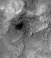
I tried to plot Spirit's progress on a route map and here are the results. Note that with the data we have it's very difficult to make an exact map; a lot of assumptions must be made. Anyway, it gives a raw idea of where the rover should be by this time (or yesterday, because there was a drive planned for sol 638).
About the future (hypotetical) path, please just disregard it. It was a first try I made some time ago and the dog-leg to the right (south) should be expected much earlier on the ridge.

|
Posted by: RNeuhaus Oct 19 2005, 01:39 PM
James,
I missed the expresion with the following: The land where Spirit will go down is considered a steep step . It would be expressed as the following: If the land where Spirit will go down is considered a steep step .
You can see the pictures which shows that that zone is flat (no high or big stones) and mostly covered by sand (I think it is of not so thick of sand). This kind of terrain, there is good control to slid down.
Rodolfo
Posted by: djellison Oct 19 2005, 02:53 PM
Ahh - THAT'S Haskin ridge, I thought it was something way down the East spur.
See your point now - that'll be fun
Doug
Posted by: jamescanvin Oct 20 2005, 01:51 AM
Just been looking at the images from Sol 637 again (yestersol) (no 638 yet ) and noticed how close to the top edge of the frame the horizon is in the front hazcam shots, Spirit is at quite an angle already.
Looking at Front and rear hazcams from the summit I think the curve of the horizon should get to about 200 pixels of the top of the hazcam frames on level ground (at the summit height above the planes). On Sol 637 there is only ~35 pixels to the top, with 0.12 degrees per pixel that means Spirit is tilted forward ~20 degrees already.
James
Posted by: sattrackpro Oct 20 2005, 02:25 AM
There could still be a drop-off ahead but from the second image Doug posted, there DOES appear to be a way through, dead ahead. At a server that I have for a domain of mine, Ive posted three cropped areas. The first from the first image Doug posted the next two from image two.
Looking at the third path down image, enlarged three times, it does appear that a diagonal line breaks through the dark ridge of what might be a drop-off. It is underlined by a white line just to the right of it. Close up, it appears there is a way through here...
See http://anyold.com/mars for the three snips from Dougs photos.
Posted by: jamescanvin Oct 20 2005, 03:03 AM
Looking at the third path down image, enlarged three times, it does appear that a diagonal line breaks through the dark ridge of what might be a drop-off. It is underlined by a white line just to the right of it. Close up, it appears there is a way through here...
See http://anyold.com/mars for the three snips from Dougs photos.
Don't get me wrong I think there definitely is still a drop off ahead (see my earlier posts). Just pointing out it's already quite steep!
I don't see the point of looking for 'paths down' as I see it we can see an easy 60m ahead then the terrain gets steeper and we can't see any of it for (guess) ~50m. All we can say so far is that it is at least 2 degrees steeper than where we are (as we can't see it), probably quite a bit more looking at the orbital data. That is probably not the problem though, we are now going across the layers of the dip slope so we could easily come across long outcrops running along the side of the hill which could be very tricky obstacle (think about having to go right over the top of Larry's lookout!)
For the record I think that it will be passible, any outcrops are very unlikley to be unbroken over any great distance. I just think it is silly to be saying "I see a way through!" at this stage when the steepest bit of the decent is hidden and could be anything from an 'easy' 20 something degree slope to great meter or more high vertical outcrops stretching right across the eastern side of Husband hill! We just don't know yet! Which of course is one of the reasons the MER missions are so exciting, we get to go and find out!
Cheers, James
Posted by: sattrackpro Oct 20 2005, 03:44 AM
True, true... as you say, we just have to go along for the ride and see...
The immediate question we face (the 'steep step') won't be the only one coming up in this descent - from what I can see there's going to be several dicey points on the way to Home Plate. With a little luck, we can hopefully avoid the need to reverse our path! Wouldn't that be the pits!
Have a great one...
Ron
Posted by: jamescanvin Oct 20 2005, 05:53 AM
No better than the navcams really but attached is a screen grab of the Sol 637 drive direction Pancam thumbnails at Pancam data tracking.

|
Would make a nice pan of where we're headed if the full versions would turn up
A Sol 638 version is also down but thumbnails are not showing up yet.
638 p2388.06 12 0 0 12 1 25 pancam_drv_dir_L7R1
James - Addict, hoping I won't have to keep reloading Exploratorium every five mins for much longer.
Posted by: jamescanvin Oct 20 2005, 06:06 AM
And with that - it's back!
http://qt.exploratorium.edu/mars/spirit/forward_hazcam/2005-10-19/2F183009804EFFAH00P1214L0M1.JPG
Posted by: jamescanvin Oct 20 2005, 06:38 AM
I don't know If you'll be able to see this better in stereo images (I don't have glasses) but using the parallax calculator It appears that there are no features between 30 and 80 meters in the dead ahead direction.
i.e in this image,

|
Terrain below the added line is closer than 30m above, further than 80m! 50 steep, unknown meters.
Posted by: jamescanvin Oct 20 2005, 07:07 AM
Sol 638 drivve direction pan
|
|
Posted by: Tesheiner Oct 20 2005, 08:10 AM
Wait a minute, James!
Did you get those pictures directly from the pancam tracking web? How?
Edit: Sometime ago I was playing with that "display_jpeg" button on the webpage with no results. Any trick?
Posted by: jvandriel Oct 20 2005, 11:46 AM
Spirit going down Husband Hill.
A last look at the summit.
Taken with the L0 Navcam.
jvandriel

|
Posted by: jvandriel Oct 20 2005, 11:53 AM
Spirit going down and looking to the left.
Taken with the L0 Navcam.
jvandriel

|
Posted by: jvandriel Oct 20 2005, 11:55 AM
Spirit going down and looking to the Right.
Taken with the L0 Navcam.
jvandriel

|
Posted by: jvandriel Oct 20 2005, 11:58 AM
and a complete overview of Inner Basin and Haskin Ridge.
Taken with the L0 Navcam.
jvandriel

|
Posted by: jvandriel Oct 20 2005, 12:35 PM
A panoramic view of Haskin Ridge.
Taken with the R1 pancam.
jvandriel
|
|
Posted by: Tesheiner Oct 20 2005, 12:39 PM
i.e in this image,
|
|
Terrain below the added line is closer than 30m above, further than 80m! 50 steep, unknown meters.
Right. But if you have a look to the pancam picture left of the one you mentioned (2P183010735EFFAH00P2388L7M1, see below) there IS a path i.e. continuity which avoids the step.

|
In two days (drives) Spirit may reach that point.
Posted by: jvandriel Oct 20 2005, 12:42 PM
After a few meters driving down Husband Hill, a new panoramic view of Haskin Ridge.
Trying to find the right way down the step.
jvandriel
|
|
Posted by: Tesheiner Oct 20 2005, 12:55 PM
Nice pano Jvandriel!
Let me use it to extend on my last comment, if you don't mind.
That's the pancam panorama taken after sol 638 drive. The step can be seen on the three rightmost frames, while the path I painted before can be seen a bit to the left of the center.
Posted by: jvandriel Oct 20 2005, 01:06 PM
Tesheiner,
I think you are right. The only place where Spirit can cross that step is where you
painted the route and a little bit more to the right.
jvandriel
Posted by: sattrackpro Oct 20 2005, 01:31 PM
I think you are right. The only place where Spirit can cross that step is where you painted the route and a little bit more to the right.
jvandriel
I hope you are BOTH right - but, James may have a point - there could be a rather sudden drop off that isn't quite so easy to see in these photos - yet...
It is possible that line he draws goes all the way across the pan... the big question is - is there any drop-off at all. What I'd like to see - is what does it look like further to the right...
There looks to be an easy and smooth descent to the floor of Gusev to the left, once down this 'step' - then a drive-around, to get back to home plate.
Posted by: RNeuhaus Oct 20 2005, 01:41 PM
) and noticed how close to the top edge of the frame the horizon is in the front hazcam shots, Spirit is at quite an angle already.Looking at Front and rear hazcams from the summit I think the curve of the horizon should get to about 200 pixels of the top of the hazcam frames on level ground (at the summit height above the planes). On Sol 637 there is only ~35 pixels to the top, with 0.12 degrees per pixel that means Spirit is tilted forward ~20 degrees already.
James
James,
I am interested on your technique to measure the slope. How do you count the pixels from the picture? I cannot see every pixel from the picture. How do you now about the measurement of 0.12 degree per pixel?
Rodolfo
Posted by: Tesheiner Oct 20 2005, 01:52 PM
It is possible that line he draws goes all the way across the pan... the big question is - is there any drop-off at all. What I'd like to see - is what does it look like further to the right...
There looks to be an easy and smooth descent to the floor of Gusev to the left, once down this 'step' - then a drive-around, to get back to home plate.
Sattrackpro,
The line plotted by James was made by measuring distance (by parallax) to known points before and after the line. Maybe you can't see a sudden drop on a single picture, but you can actually "see" it by checking both L&R images (in 3D).
The path I painted on my previous post has no such discontinuity. What does it mean? That the distance smoothly increases on the whole path; there is no sudden jump on the measured distance, meaning that there is no step.
Posted by: RNeuhaus Oct 20 2005, 02:27 PM
The attached picture is my path recommendation. Avoid whenever as possible to pass over the stones (they make more problems with slipping and unstabilizing by the difference of height). Prefer to go down over the sandy land.
I have traced two paths : the yellow's one is possible but much dangerous and the blue's one is the best.
Rodolfo
P.S.I learned that the pancam pictures are the best ones to study the land. Navcam pictures showed me a false impresion of land surface. Even better if it is analghphy?? in combination with bearing of red and blue eyeglass.
|
|
Posted by: Tesheiner Oct 20 2005, 03:00 PM
Rodolfo, take a look at the discussion about the "step" on this same thread.
Posted by: RNeuhaus Oct 20 2005, 03:11 PM
What thread?
. Remember, that the MER ladies are capable to incline as much as 45 degree but only up to 30 degree as safety margin. When I goes down on a big dunes (above than 100 meters), my truck can behave very well on slope of 30 degree without any problems of control (use a very slow rpm engine as a brake). However, the Haskin Ridge has more stones so it must go with more care in touching as less as possible on them.Rodolfo

|

|
Posted by: Burmese Oct 20 2005, 04:18 PM
Looking back, the rover tracks look very peculiar.
http://qt.exploratorium.edu/mars/spirit/rear_hazcam/2005-10-19/2R183009753EFFAH00P1312L0M1.JPG
Why all the scuffling back and forth every foot of the way? It's as if the rover is practicing a side-slip method for edging downhill on a steep slope.
Posted by: RNeuhaus Oct 20 2005, 04:27 PM
Yes, I think it so.
I seems that this is not a good practice since it increases the risks to loose the stability. The wheels must be on straight line on the gravity for a better traction control.
I see that Spirit is not experiencing much slippage. She went on the right way where there are fewer stones.
Rodolfo
Posted by: Tesheiner Oct 20 2005, 04:29 PM
Burmese,
Looking that picture and also taking into account Spirit was driving three days in a row (including today) while Oppy was driving four days in a row (today too), I must ask:
What were those guys at JPL smoking this week?
Posted by: odave Oct 20 2005, 04:36 PM
Using http://www.unmannedspaceflight.com/index.php?showtopic=1506&view=findpost&p=24011 and the usual MOC image, it seems to me that there are enough unique features visible to derive Spirit's current location on the ridge:

|
But I'm not sure how to transfer the angles. Any of you pros care to try?
Posted by: Burmese Oct 20 2005, 05:10 PM
When Spirit 1st started to climb the hills, they modified the autonomous driving program such that if the rover detected slip over a certain threshold, it's 1st reaction would be to change direction slightly and attempt to 'tack' up the slope. Perhaps they will apply the same algorithm for going downslope, with the slip threshold reversed, but this current slope doesn't seem to be the sort to induce any slip at all yet.
Posted by: RNeuhaus Oct 20 2005, 06:26 PM
That algorithm is sure good. It applies the same to the off road which is to steer on the both sides when the wheels starts to slip.
Rodolfo
Posted by: stewjack Oct 20 2005, 11:13 PM
[B]Watch that first step![/B}
An Animated gif for the 3D challenged
The big step is close to the bottom of the image - don't miss it.
Haskin Ridge Flicker
File size 500 Kb
[attachment=1923:attachment]
Posted by: jamescanvin Oct 20 2005, 11:14 PM
Did you get those pictures directly from the pancam tracking web? How?
Edit: Sometime ago I was playing with that "display_jpeg" button on the webpage with no results. Any trick?
I discoved this some time ago, last time we had a major outage at JPL and Expl (when the Tracking site was first found) I have mentioned it in this forum somewhere.
The trick is, do you see that big button titled "Table of All Images From All Sols"?
(Just below the select sols box) well give it a click...Then find the seqence you want and click on the link in the "Seq.Ver.Iter" column and hey presto you should get some 200 x 200 thumbnails.
James
Posted by: Sunspot Oct 20 2005, 11:15 PM
An Animated gif for the 3D challenged
The big step is close to the bottom of the image - don't miss it.
Haskin Ridge Flicker
File size 500 Kb
[attachment=1923:attachment]
Ahhhhhhh so that's the step lol .. couldn't make it out until now.
.. another drive by the way
http://qt.exploratorium.edu/mars/spirit/forward_hazcam/2005-10-20/2F183094619EFFAI00P1214R0M1.JPG
Posted by: jamescanvin Oct 20 2005, 11:23 PM
I am interested on your technique to measure the slope. How do you count the pixels from the picture? I cannot see every pixel from the picture. How do you now about the measurement of 0.12 degree per pixel?
Rodolfo
To count pixels load the image into a graphics package (I use the GIMP) but I think most do this as a standard and the current pixel that the mouse is pointed at is given in the lower-left corner.
0.12 degrees per pixel is the angular resolution of the hazcams, that infomation is on the web, can't find it again off hand, it's probably on the ATHENA site.
James
Posted by: jamescanvin Oct 21 2005, 12:01 AM
The line plotted by James was made by measuring distance (by parallax) to known points before and after the line. Maybe you can't see a sudden drop on a single picture, but you can actually "see" it by checking both L&R images (in 3D).
The path I painted on my previous post has no such discontinuity. What does it mean? That the distance smoothly increases on the whole path; there is no sudden jump on the measured distance, meaning that there is no step.
I hoped you were right too, but unfortunately you're not!
See this attached image

|
http://qt.exploratorium.edu/mars/spirit/pancam/2005-10-20/2P183095498EFFAI00P2389R1M1.JPG
I have matched up some of the features (red lines) near the end of your 'path' and you can see from the latest images that a whole load more ground has been revealed! I have also used parallax on a couple of features between us and the path end showing that there is still 40 meters unseen!
I'm starting to worry a bit more now.
The closer we get the worse it looks! James
Posted by: alan Oct 21 2005, 12:24 AM
Looks like a good place to spend the weekend
http://qt.exploratorium.edu/mars/spirit/navcam/2005-10-20/2N183094701EFFAI00P0655R0M1.JPG
Posted by: jamescanvin Oct 21 2005, 12:37 AM
Based on the latest forward hazcam image:
Spirit current angle ~14 degrees.
Slope between current position and top of steep step ~19 degrees.
Slope of steep step (based on the fact that the pancam can't see it) >23 degrees.
This is not a rigorous analysis by any means, but should be within a few degrees.
James
Posted by: mhoward Oct 21 2005, 01:24 AM
The dropoff looks even worse in the anaglyphs than it does in the animated gif. I hope it just looks worse than it is.
Posted by: jamescanvin Oct 21 2005, 01:34 AM
Perhaps it's a good thing that I don't have any 3D glasses then!
Posted by: RNeuhaus Oct 21 2005, 03:12 AM
If it is confirmed that the probably way will meet a dropoff, then Spirit will turn to any sides. The slope of around 20 degree is somewhat tough to turn unless that kind of terrain that is not very sandy but it is somewhat compact that helps to Spirit to turn right/left easier.
At all, on the general perspective, there is no cliff but some small dropoff and there are continues slopes on the other sides. That is what I am not worried of this.
Rodolfo
Posted by: CosmicRocker Oct 21 2005, 05:34 AM
It looks pretty darned steep to me. I would have liked to see 1 or 2 more frames toward the right. There might be an escape ramp there.
But I'll admit that I have previously thought they were were crazy to attempt some of the apparent slopes they successfully navigated with both rovers in the past. I'm tightly holding on to both arms of my chair...
YeeHaaa!!!
Posted by: Tman Oct 21 2005, 09:26 AM
Full-res. stitching of six Pancam frames from sol639:
(2 MB) http://www.greuti.ch/spirit/spirit_panR1_sol639.jpg
(to me) no way so far!
Hope when we get closer one appears..., only two meters wide
But take a look at this (I guess) wind formed wavy ground ahead! It seems there is a heavy wind canal
Posted by: Tesheiner Oct 21 2005, 09:56 AM
I have matched up some of the features (red lines) near the end of your 'path' and you can see from the latest images that a whole load more ground has been revealed! I have also used parallax on a couple of features between us and the path end showing that there is still 40 meters unseen!
Right. I just realised that today when looking at those fresh sol 639 images.
And a quick parallax calculation places the step some 20m ahead.
BTW, Spirit is now on sol 640 and it's not a driving sol. Searching for a path?
Posted by: vikingmars Oct 21 2005, 10:14 AM
...Or maybe we stop and go for those interesting whitish rocks.
Hmmm... Miam- miam (Yum-yum in English) !

|
Posted by: abalone Oct 21 2005, 10:40 AM
Anaglyph of the same scene. At the extreme right could be a flatter area to go down

|
Posted by: abalone Oct 21 2005, 10:43 AM
Give me your address and I will mail you two pieces of red and blue cellophane
Posted by: Tesheiner Oct 21 2005, 11:47 AM
The trick is, do you see that big button titled "Table of All Images From All Sols"?
(Just below the select sols box) well give it a click...Then find the seqence you want and click on the link in the "Seq.Ver.Iter" column and hey presto you should get some 200 x 200 thumbnails.
James
Wonderful!
I did a little bit of "research" and now I know why the "display_jpeg" button didn't worked for me. Because the only JPGs available are from pancam images; nothing from other instruments.
If you don't know yet, let me tell you how to use that button; it's a nice short cut and you don't need to load the whole table of all images.
Like usually, select a sol and the "detailed report". Then click on one of those seq.ID links under the "Seq.Ver." column of section 1 or 2. You will get just a list of filenames. But have a look on that editable field named "Database Search: Enter MySQL query here:" and you will see (among a lot of other stuff) something like "t2.ObsID = '<string>'".
Copy that <string>, paste it on the "ObsID:" editable field, click on the "display_jpeg" button, and voila!
Posted by: ElkGroveDan Oct 21 2005, 02:12 PM
Wow the analglyph makes all the difference in the world.
I'm thinking a slow approach up and to the left could reveal a more gradual entry to this slope.
Posted by: abalone Oct 21 2005, 02:50 PM
Could be correct too. The change in elevation to the ridge beyond is the smallest here
Posted by: Tesheiner Oct 21 2005, 03:02 PM
Here is a sol 639 pancam panorama with the calculated distances to some features nearby the step.
|
|
Posted by: GregM Oct 21 2005, 05:05 PM
.
Posted by: mhoward Oct 21 2005, 06:05 PM
Spirit will have no problem!
Yeee-ha!
Darn them Duke boys...!
Posted by: alan Oct 21 2005, 06:30 PM
Spirits not going to fly very far traveling at a few cm/sec
Posted by: RNeuhaus Oct 21 2005, 08:47 PM
Spirit advanced few meters and has turned on Left.... (east)
http://qt.exploratorium.edu/mars/spirit/navcam/2005-10-21/2N183087109EFFAH00P1755R0M1.JPG
http://qt.exploratorium.edu/mars/spirit/navcam/2005-10-21/2N183087255EFFAH00P1755L0M1.JPG
Rodolfo
Posted by: stewjack Oct 21 2005, 09:17 PM
Now even common people, without colored glasses, can see that the apparent ledge is quite wide.
I used Abalone's anaglyph to create a flicker. All the hard work was already done.
File size 500 Kb
[attachment=1948:attachment]
Posted by: Myran Oct 21 2005, 09:59 PM
And now my eyes flicker too! 
Thank you stewjack, I can see the depth nicely there.
Posted by: jamescanvin Oct 22 2005, 01:16 AM
http://qt.exploratorium.edu/mars/spirit/navcam/2005-10-21/2N183087109EFFAH00P1755R0M1.JPG
http://qt.exploratorium.edu/mars/spirit/navcam/2005-10-21/2N183087255EFFAH00P1755L0M1.JPG
Rodolfo
Note those were from yestersol (639) there was no driving tosol (640)
Posted by: RNeuhaus Oct 22 2005, 02:02 AM
Thank you for the correction. You know that it is very hard to decode the sol from the filename of the picture such as the ones like this: 2N183087021EFFAH00P1755L0M1.JPG
Report update Oct 21, 2005
Elevation maps produced from the panoramic camera imagery taken at and near the summit of Husband Hill showed a safe traverse (with vehicle tilts under about 20 degrees) across ridge lines east of the summit. These ridge lines (informally called "Haskin upper ridge" and "Haskin east ridge") are the planned traverse paths for coming weeks. When possible, Spirit will drive each day.
Sol 639: Spirit covered 17 meters (56 feet) during the third drive of the approach to Haskin upper ridge. This left Spirit about 15 meters (49 feet) from the drop-off and near an area with rock outcrops.
Sol 640: Spirit's planned activities for sol 640 were devoted to remote sensing of the east basin, expected to be within view after the third leg of the sol 639 drive.
This looks that the JPL guys are confident and are not much worried (yes a little) of the steep step since the MER is a very capable girl:
ROVER NAVIGATION DURING SURFACE OPERATIONS
Keeping the rover right side up and balanced
The rover's Inertial Measurement Unit (IMU) uses gyroscopes and accelerometers to determine the heading and tilt of the rover. The gyroscopes measure small heading changes very accurately, and the accelerometers measure where gravity is strongest, pulling down on the rover. Having knowledge of where gravity (down) is, the rover can partly assess its orientation. The rover will also use its tilt sensors to prevent rollover.
If the IMU fails or the rover is lost, the flight team can use the Pancam, which is not part of the autonomous system, to try to figure out the rover direction and position relative to the horizon (attitude).
Rodolfo
Posted by: jamescanvin Oct 22 2005, 02:29 AM
Yes, but it is relatively easy to check the timestamp against some of the latest images (rear hazcam is a good one if your interested in driving) For sol 639 the end of drive time starts 18309, the ones you posted had 18308 and hence don't show a new drive.
Also I beleve somewhere this is a utility for decoding filenames, and of course there is also MMB.
James
Posted by: sattrackpro Oct 22 2005, 10:03 AM
I wrote my own, but it's not quite to my satisfaction (finished) - so if anyone knows where we can avail ourselves of said utility, by all means point the way
Posted by: dot.dk Oct 22 2005, 11:24 AM
I will point the way then
http://www.unmannedspaceflight.com/index.php?showtopic=109&pid=19457&st=0&#entry19457
Posted by: Tesheiner Oct 22 2005, 11:47 AM
Dot.dk already posted the info about "rawid" tool.
Let me add that a quick and easy way to know if a rover has moved or not is by checking the site/drive id on the image filenames.
Rodolfo,
You made a reference to the file 2N183087021EFFAH00P1755L0M1.JPG.
Pictures taken on a different place, regardless of sol, will have an id different of AH00.
Spirit is currently on site/drive AI00. After the next drive she will be at AJ00 or AIxx.
Posted by: CosmicRocker Oct 23 2005, 03:58 AM
Yeah, there is just a hint of a slighter slope down at the far right. Thanks for the excellent anaglyph panorama.
I missed the one on the left. As ElkGroveDan pointed out, there is another hint of a slighter slope down on the far left...and as you mention, the elevation change there to the next ridge is smaller.
Where have I heard that before?
http://www.unmannedspaceflight.com/index.php?showtopic=1506&st=105&#
There's much to be said about being an armchair rover rider, or should I say a wheelchair rover rider?
Spirit needs to bump up a little closer to the precipice (dare I say, Abyss), to better image the options.
Posted by: RNeuhaus Oct 23 2005, 05:41 PM
Let me add that a quick and easy way to know if a rover has moved or not is by checking the site/drive id on the image filenames.
Rodolfo,
You made a reference to the file 2N183087021EFFAH00P1755L0M1.JPG.
Pictures taken on a different place, regardless of sol, will have an id different of AH00.
Spirit is currently on site/drive AI00. After the next drive she will be at AJ00 or AIxx.
Tesheiner: Muito bem. Perfecto
I am starting to learn to interpret the columns : 15-16 (Site Number as site location), 17- 18 (Drive number -position within Site Count). About the Site Number, how do they name it? Every sol, a new site location or every stop for more than seversl minutes is a new site location or whatever else you tell me.
P.D.More details about http://marsrovers.jpl.nasa.gov/gallery/edr_filename_key.html
Rodolfo
Posted by: fredk Oct 23 2005, 07:12 PM
We can actually constrain the slope of the hidden dropoff ahead of us on Haskin ridge in a very simple way - we don't need to know the slope Spirit is currently on or the distance to the dropoff or anything.
The attached sketch shows Spirit at its current location heading downhill, with the hidden dropoff slope indicated by a "?". It's clear from the sketch that the angular slope of the hidden dropoff must be more than the angle I've called greek theta.
But theta is easy to measure from navcam imagery. http://marsrovers.jpl.nasa.gov/gallery/all/2/n/639/2N183094773EFFAI00P0655L0M1.JPG is the view ahead from the current position (according to the latest sol 640 imagery). To measure theta we simply count pixels from the horizon to the visible edge of the dropoff and convert to degrees. Doing this I find that the slope of the dropoff must be greater than about 16 degrees. The biggest uncertainty is in locating the horizon in the navcam image (I added a half degree for the horizon drop due to altitude).
This shows that there is plenty of room for an easily navigable dropoff - 16 to 20 degrees or even more should pose no problem, especially downhill. Off course this just gives a lower limit - an 80 degree cliff is certainly a possibility!

|
Posted by: jamescanvin Oct 24 2005, 12:45 AM
Unfortunately it's a good deal bigger than that!
I'm not sure what height difference to take for the surrounding plains in the summit JPL press release they say 82m but 106m above the landing site. I guess the 82m is the height of the summit above the plains right next to the hills, where as we need to know the height of the plains on the horizon which considering the difference in height to the lander could be quite different.
Being ]really conservative and using 60m as our current hight above the plains that still means the horizion is 10.5 degrees below the horizontal, and thus what you are really saying is that the steep slope is >26 degrees!
Note that in http://www.unmannedspaceflight.com/index.php?showtopic=1506&view=findpost&p=24087 about the slope using the hazcam, 200 pixels below the top of the frame equates to 9 degrees below the horizontal and is the reason that the limits are different. (I now think that should have been using a higher number than 200 anyway as I had forgotton at the time that the rear hazcam is angled differently to the front, doh!
I still maintain however that it's not the steepness that will be the problem but rocky near vertical outcrops that could make up the slope.
James: waiting with great anticipation for the next 10m.
Posted by: fredk Oct 24 2005, 12:59 AM
Being really conservative and using 60m as our current hight above the plains that still means the horizion is 10.5 degrees below the horizontal, and thus what you are really saying is that the steep slope is >26 degrees!
James: waiting with great anticipation for the next 10m.
James, I think you must be out by a factor of ten or the like somewhere! For height h above a sphere of radius r, the horizon drops by squareroot(2h/r) radians, for small h/r.
Plugging in your conservative h=60m, and r=3 400 000m, I get 0.34 degrees. You really need to get to planetary heights to see horizons drop by 10 degrees!
Posted by: jamescanvin Oct 24 2005, 01:01 AM
...For comparison here is a quote from Steves last update
>27 = very steep!
Posted by: jamescanvin Oct 24 2005, 01:12 AM
Plugging in your conservative h=60m, and r=3 400 000m, I get 0.34 degrees. You really need to get to planetary heights to see horizons drop by 10 degrees!
oops! more like a factor of 1000. (m => km)!
So what's going on with the horizon in the summit hazcams, let me get back to you...
Posted by: jamescanvin Oct 24 2005, 01:53 AM
OK, it looks like the source I have frrom the angle the hazcams are mounted was in error.
Corrected gives Spirit a current tilt of 10 degrees with that 10 degree slope continuing to the edge.
Posted by: Tesheiner Oct 24 2005, 09:13 AM
The site number is named by the rover planners in advance to the drive. It's usually set upon significant stops, but its assignment may be quite subjective; you never know when it will happen.
Last sites for Oppy were:
60: Erebus Highway (sol 580)
61: South Shetland (sol 591)
62: South Shetland (sol 592)
63: big outcrop from where they started moving NW (sol 617)
The drive number is more or less related to "wheel steps". But those steps are not of fixed lenght so it's usually not possible to derive any driving distance from them, at least for me.
Posted by: jvandriel Oct 24 2005, 10:36 AM
Going down Husband Hill.
A 360 degree Navcam panoramic view taken on Sol 638-639 with the L0 Navcam.
jvandriel
|
|
Posted by: jvandriel Oct 24 2005, 10:39 AM
and another one taken on Sol 639-640 with the L0 Navcam.
|
|
Posted by: Tman Oct 24 2005, 02:55 PM
There are already new images from sol 642 on JPL's site! But not yet better visible where Spirit could go. A new big but rather transparent DD on or behind the ridge: http://marsrovers.jpl.nasa.gov/gallery/all/2/n/642/2N183359962EFFAI38P0655R0M1.HTML
Posted by: vikingmars Oct 24 2005, 03:18 PM
(following post #116) Well... Before going down, we are first having a look on "white" rocks ! Yum-yum !

|
Posted by: vikingmars Oct 24 2005, 03:30 PM
...And here is a color image of the rocks !
Enjoy !

|
Posted by: Tman Oct 24 2005, 03:49 PM
http://athena.cornell.edu/news/mubss/ it's called "Kansas":
(Update from 24.10) "At Gusev, Spirit is working her way nicely down the upper portion of Haskin Ridge. We're within a few tens of meters of the top of the step now, and we've stopped for a bit of IDD work on a new outcrop called Kansas. No idea what it's made of yet, but we should get some clues over the next couple of days".
Posted by: fredk Oct 24 2005, 05:43 PM
A bit of downslope movement sol 642. From http://marsrovers.jpl.nasa.gov/gallery/all/2/n/642/2N183359962EFFAI38P0655L0M1.JPG latest navcam shot, my technique gives only a slightly tighter constraint on the dropoff slope of a half degree or so, so the slope must exceed 16 or 17 degrees.
Posted by: jvandriel Oct 24 2005, 06:14 PM
Is this the place to cross the steep step to Haskin Ridge ?
Taken with the L7 Pancam on Sol 642.
jvandriel

|
Posted by: fredk Oct 24 2005, 07:02 PM
Nope - that view is farther back on Haskin. You can see part of it in the upper left corner of http://marsrovers.jpl.nasa.gov/gallery/all/2/p/642/2P183361801EFFAI38P2390L7M1.JPG
Posted by: jvandriel Oct 25 2005, 08:33 AM
A 360 degree panoramic view down Husband Hill.
Taken on Sol 642 with the R0 Navcam.
jvandriel
|
|
Posted by: jvandriel Oct 25 2005, 09:04 AM
A pancam panoramic view looking down at Haskin Ridge.
Taken on Sol 642 with the L7 pancam.
jvandriel
|
|
Posted by: abalone Oct 25 2005, 12:27 PM
Latest anaglyph looking ahead. Looks like you can almost see over the top at the left.
Complete with DD in background

|
Posted by: RNeuhaus Oct 25 2005, 02:08 PM
Taken on Sol 642 with the L7 pancam.
Now, this last panaromic picture gives me an observation, the dropoff line is not covered by any kind of rocks, cliff but a continuation of the same kind of land from the rover. This deduct me that the land after the dropoff is of the same kind of terrain as the previous.
Now let me see if my supposition is right
Rodolfo
Posted by: Sunspot Oct 25 2005, 02:10 PM
Anyone else unable to access the exploratorium websites?
Posted by: odave Oct 25 2005, 02:20 PM
I can't get them either - gateway timeouts on the rover folders and an internal server error on the main exploratorium page.
Posted by: Myran Oct 25 2005, 02:53 PM
Exploratorium is down for me also, should be working hours in the US now but no - well lets wait and see.
Posted by: jvandriel Oct 25 2005, 06:07 PM
Bedrock on the way down.
A panoramic view of that place.
Taken on Sol 643 with the L5 pancam.
jvandriel

|
Posted by: aldo12xu Oct 25 2005, 06:51 PM
Jvandriel, your latest panoramas and mosaics have been exceptional. It looks like you have perfected the process!
The one thing that stood out for me in the above mosaic is the difference in the morphology of the outcrops near the upper portion of the photo versus that of the outcrops making up most of the photo. Could we have a geological contact running along the upper part of the mosaic? If so, any idea what the trend/direction of that contact is?
Posted by: jvandriel Oct 26 2005, 09:25 AM
Aldo12xu,
when you look at post#153 of this thread, the 2 center images, you can see that whole area.
I am not a geologist to draw any conclusion about that.
Regarding the panoramas.
I use MichaelT's anti-vignetting program and IDL Virtual machine before stitching.
As you can see from the results, it works great and the results are much better than before.
Almost no more vignetting.Especially the Navcam images.
jvandriel.
Posted by: Tesheiner Oct 26 2005, 09:31 AM
Jvandriel,
I suppose you are still using autostitch. Have you seen or not an improvement on the images matching (better horizon with less discontinuity) after using anti-vignetting?
Posted by: jvandriel Oct 26 2005, 11:35 AM
Tesheiner,
I still use Autostitch voor stitching and indeed it looks like that there is more matching of the horizon.
Maybe the result of MichaelT's anti-vignetting program because there is more contrast between the dark Mars soil and lighter sky above it. Especially at the seams. With more contrast difference it's easyer for better matching and stitching.
But you can also force Autostitch for better matching by changing the RANSAC parameters.
I have made a lot of panoramas and gained more experience with Autostitch, maybe that will help to.
But in general I must say that the anti-vignetting program of MichaelT is a great help for making better panoramas. Special in the Navcam panoramas you can see much better results.
In the pancam images it is less, because they have less vignetting as explained earlier in another thread.
jvandriel
Posted by: jvandriel Oct 29 2005, 11:46 AM
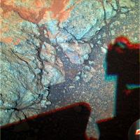
A panoramic view of Kansas.
Taken with the Microscopic Imager on Sol 646.
jvandriel

|
Posted by: jamescanvin Oct 31 2005, 12:34 AM
Well data tracking is back and it looks like were back on the road tosol (649)
649 p0655.03 0 0 0 0 0 0 navcam_5x1_az_90_3_bpp
649 p1201.17 0 0 0 0 0 0 front_haz_penultimate_1_bpp_crit_16
649 p1214.05 0 0 0 0 0 0 front_hazcam_ultimate_4_bpp
649 p1301.06 0 0 0 0 0 0 penultimate_rear_hazcam_pri_16
649 p1312.09 0 0 0 0 0 0 ultimate_rear_hazcam_2_bpp_pri15
649 p1755.01 0 0 0 0 0 0 navcam_5x1_az_270_1_bpp
and including
649 p2396.06 0 0 0 0 0 0 pancam_drive_direction_6cx1r_L7R1
James - hoping for a view down the step...
Posted by: RNeuhaus Oct 31 2005, 02:00 AM
What disbelief is that PANCAM Data Tracking is back after we have speculated that it was protected by the userid and password identification was due of others reasons...
I am happy it is back again. Hope we don't abuse it since it is a Web dynamic driven that consumes lots of CPU cycles.
My guess to PANCAM Data Tracking as the following
navcam_5x1_az_90_3_bpp ---------------> Take 5 pictures to south side
front_haz_penultimate_1_bpp_crit_16 --> Take front picture early
front_hazcam_ultimate_4_bpp ------------> Take front picture after some ride
penultimate_rear_hazcam_pri_16 ---------> Take rear picture early (same as front)
ultimate_rear_hazcam_2_bpp_pri15 ------> Take rear picture after some ride.
navcam_5x1_az_270_1_bpp --------------> Take 5 picture to east side
and including
pancam_drive_direction_6cx1r_L7R1 ----> Take 6 pictures of PANCAM in drive direction
Rodolfo
Posted by: jamescanvin Oct 31 2005, 03:09 AM
navcam_5x1_az_90_3_bpp ---------------> Take 5 pictures to south side
front_haz_penultimate_1_bpp_crit_16 --> Take front picture early
front_hazcam_ultimate_4_bpp ------------> Take front picture after some ride
penultimate_rear_hazcam_pri_16 ---------> Take rear picture early (same as front)
ultimate_rear_hazcam_2_bpp_pri15 ------> Take rear picture after some ride.
navcam_5x1_az_270_1_bpp --------------> Take 5 picture to east side
and including
pancam_drive_direction_6cx1r_L7R1 ----> Take 6 pictures of PANCAM in drive direction
Rodolfo
Yes, clearly we have a drive with 360 deg navcam pan and 6 frame pancam pan of the drop-off after, like we've seen many times already. (There also looks like there will be some pancam work of the area they have just been working and of the RAT.)
Question is: How far will the drive be? We were only 20m from the drop-off so we could end up quite close to it after this drive. Here's hoping!
James
Posted by: edstrick Oct 31 2005, 10:39 AM
Here's a Band L2 and L7 two-color image of the RAT-Brushed target they're investigating 20 meters from the presumed step down toward Haskin ridge.
VERY interesting texture.

|
Posted by: edstrick Oct 31 2005, 10:58 AM
From a few days ago, and a couple days or so before that.. some of the rocks on the descending slope. Sharpened color from band L2/L5/L7 raw images. Contrast tweeked, but color not boosted other than from the pre-stretch the raws were given.
2P183362581EFFAI38P2556L2M1_257.jpg looks like rotten concrete. Very clearly a grungy clastic rock, looking not very well assembled from ground up crud. Very techical geologic terms, these!. Well... Clastic is.
2P182828219EFFAF00P2456L2M1_257.jpg has infinite color variations on the rock surfaces, but most of it is dominated by adhering dust and weathering rinds or other coatings on the surfaces. Jim Bell and the Pancan team can see spectral classes of rocks in the 11 channel data, but I sure can't tell them from the color pics made from 3 bands of raw data.
Eventually, we'll need software that can look at a MSL scene and sort multiband data into color combinations that suppress the high contrast ferric dust features and bring out the variations in underlying rock, so we can look at a pan and say... We've done "those".. I want to take a good look at "THAT" one.. it's DIFFERENT. And we'll need to be able to do it in time for tomorrows science planning meeting to uplink the rock's coordinates and a "go GET IT" command to the rover.

|
|
Posted by: helvick Oct 31 2005, 12:04 PM
That's an interesting topic, and somewhat in line with Steve Squyres' comments on capabilities for next gen missions. Right now the MER drivers and planners have to do a lot of work just to move from point to point, get their bearings and check the atmospheric conditions before doing anything. On top of that the science guys have to slog through loads of data to pick out targets. All good work and plenty of fun but I'm curious about how much autonomy is planned for MSL. In terms of covering ground it would be much smarter to be able to upload a local terrain model (from MRO I assume) throw in some way points and have automated systems exhaustively characterise multispectral reconnaissance pans on the fly searching for anything out of the ordinary.
I don't think that can be done yet, or at least can't be done yet with a high enough level of confidence to rely on it. If that is the case is MSL going to be limited to a similar rate of progress to the MER's ?
Posted by: fredk Oct 31 2005, 05:35 PM
New navcam imagery of the dropoff http://marsrovers.jpl.nasa.gov/gallery/all/2/n/649/2N183985864EFFAIA6P0655L0M1.JPG on sol 649 after the latest drive. Looking at the LR pair in 3D, it looks like our line of sight is now just parallel to the steepest part of the dropoff slope, ie we are just able to see almost all of the slope. Therefore my slope technique gives 20 to 21 degrees for the steepest part, which sounds totally doable!
Posted by: Tesheiner Oct 31 2005, 06:35 PM
Parallax measurements on navcam pics say that sol 649 drive was about 14m.
Posted by: Tman Oct 31 2005, 06:54 PM
Spirit you are on the right track...
(2,13 MB) http://www.greuti.ch/spirit/spirit_pancam_sol649.jpg
There is a way, isn'it!
Btw. on Exploratorium the 2005-10-31 Pancam file that's huge and slow - but it's alive! Thank you Exploratorium!
Posted by: Tman Oct 31 2005, 07:45 PM
In the pancam images it is less, because they have less vignetting as explained earlier in another thread.
jvandriel
I used MichaelT's anti-vignetting program for my last three L7/R1 Pancam pans too. Would like to say, along with PTGui the process getting a good result is faster and easier with it. The single frame becomes more balance in brightness/darkness and match already better before finally processing in PS. And I have to add, pans without any automatic brightness/color correction during stitching (so far).
Posted by: Tesheiner Oct 31 2005, 09:01 PM
Think so.
I see plenty of possible ways to go down; here is my preferred one.
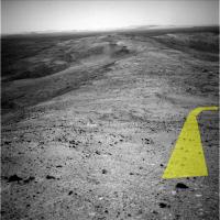
|
Posted by: RNeuhaus Oct 31 2005, 09:25 PM
I see plenty of possible ways to go down; here is my preferred one.
By that yellow way there are no interesting stones or rocks....
Rodolfo
Posted by: ElkGroveDan Oct 31 2005, 09:51 PM
Your rover is leaking something.
Posted by: ilbasso Oct 31 2005, 10:59 PM
Follow the Yellow Brick Road!
Posted by: Tman Nov 1 2005, 08:59 AM
Can anybody find a match between the sol 649 Navcams and Pancams? I guess the part of Tesheiner's yellow path isn't visible in the Pancams from sol 649.
Posted by: Tesheiner Nov 1 2005, 02:23 PM
Yes I can, Tman.
Here is a very raw combo of the center navcam, including the arrow/path, and your pancam pano.

|
Posted by: Tman Nov 1 2005, 03:30 PM
Yeah, it seems now your yellow path is nearly the best - also visible now in the Pancams. That's great it should be so easy now! A long way round had cost many of Spirit valuable sols.
In the meantime (after intensive search ) I found it too and made a short GIF of it: (1,4 MB full-res.) http://www.greuti.ch/spirit/spirit_sol649.gif
Posted by: mhoward Nov 1 2005, 04:15 PM
http://www.flickr.com/photo_zoom.gne?id=58563638&size=o
http://www.flickr.com/photo_zoom.gne?id=58563631&size=o&context=photostream
Posted by: djellison Nov 2 2005, 01:04 AM

http://www.unmannedspaceflight.com/doug_images/0648A_256_3x1_South.jpg (580kb)
Posted by: jamescanvin Nov 2 2005, 02:14 AM
http://www.unmannedspaceflight.com/doug_images/0648A_256_3x1_South.jpg (580kb)
Good to see you've started to address the S1K problem
Posted by: djellison Nov 2 2005, 02:16 AM
Thought I would given that I'm now on my new laptop...
oh, did I not mention it..
My UBER LAPTOP WITH 17" 1920x1200 screen oh BABY
Yup - trying to keep things a bit more organised, it was highly eclectic on 'Geri' (my old laptop) but it's all a bit more organised on FatBoySlilm (my new laptop)
I decided that allowing for the S10K bug would be silly.
Doug
Posted by: dot.dk Nov 2 2005, 02:26 AM
I decided that allowing for the S10K bug would be silly.
Doug
I think your new laptop will be somewhat outdated before the S10K bug comes around
Posted by: vikingmars Nov 2 2005, 12:44 PM
...Well, leaving the mass for "All Saints day" yesterday morning in our village in Burgundy, I saw a strange hole on a rock. It was real : was a MER rover there ?
==> Thanks again to this wonderful UnmannedSpaceflight site and his nice management (AlexBlackwell and Doug) !
(answer : a road signpost was removed recently)

|
Posted by: TheChemist Nov 2 2005, 02:09 PM
Any guesses on what was written on this "recently removed road signpost" on Haskin ridge ?
http://marsrovers.jpl.nasa.gov/gallery/all/2/p/648/2P183889194EFFAI38P2575L2M1.HTML

|
Posted by: RNeuhaus Nov 2 2005, 02:20 PM
The light color and rounded stone is an interesting thing and it is worth to inspect it since it is very, very different than the rest. It looks like an eroded stone by water since it has no sharp edges.
Rodolfo
Posted by: TheChemist Nov 2 2005, 02:28 PM
Unfortunately, Spirit rolled literally beside this rock around Sol 638-639, and is now locatedmuch lower on the ridge.
I haven't located any close up images of it (anyone else ?), and I think it was not studied with the instruments.
Posted by: odave Nov 2 2005, 02:43 PM

Posted by: Tman Nov 2 2005, 03:07 PM
Posted by: general Nov 2 2005, 03:14 PM

Posted by: alan Nov 2 2005, 11:13 PM
I don't see any road hazards ahead
http://qt.exploratorium.edu/mars/spirit/navcam/2005-11-02/2N184160315EFFAIBMP1908L0M1.JPG
Posted by: mhoward Nov 2 2005, 11:38 PM
http://qt.exploratorium.edu/mars/spirit/navcam/2005-11-02/2N184160315EFFAIBMP1908L0M1.JPG
Indeed, I think we're perhaps halfway down the shelf. I guess the dropoff wasn't such a big deal after all.
Posted by: jamescanvin Nov 3 2005, 12:30 AM
An analysis of the latest hazcams (651)
http://nasa.exploratorium.edu/mars/spirit/forward_hazcam/2005-11-02/2F184159045EFFAIBCP1201L0M1.JPG
http://nasa.exploratorium.edu/mars/spirit/forward_hazcam/2005-11-01/2F184160178EFFAIBMP1214L0M1.JPG
Shows that Spirt is currently on a ~16 degree slope
Looking at the latest navcam images e.g http://nasa.exploratorium.edu/mars/spirit/navcam/2005-11-02/2N184160315EFFAIBMP1908L0M1.JPG. A quick analysis on a few rocks on the road ahead shows that the slope is a pretty constant ~17 degrees.
No problem!
James
Posted by: abalone Nov 3 2005, 10:23 AM
[url=http://nasa.exploratorium.edu/mars/spirit/forward_hazcam/2005-11-
Shows that Spirt is currently on a ~16 degree slope
Looking at the latest navcam images e.g http://nasa.exploratorium.edu/mars/spirit/navcam/2005-11-02/2N184160315EFFAIBMP1908L0M1.JPG. A quick analysis on a few rocks on the road ahead shows that the slope is a pretty constant ~17 degrees.
No problem!
James
Anaglyph of latest hazcam

|
Posted by: jvandriel Nov 3 2005, 01:24 PM
A panoramic view of Haskin Ridge.
Taken with the R0 Navcam on Sol 649.
jvandriel

|
Posted by: Tesheiner Nov 3 2005, 01:50 PM
Bookmark sol 653:
---
653 p2095.10 5 5 0 0 2 12 pancam_cal_targ_L256R27
653 p2095.10 5 5 0 0 2 12 pancam_cal_targ_L256R27
653 p2095.10 5 5 0 0 2 12 pancam_cal_targ_L256R27
653 p2297.04 45 0 0 45 4 94 pancam_east_basin_pt1_L256R27
653 p2298.04 55 0 0 55 4 114 pancam_east_basin_pt2_L256R27
653 p2600.07 2 2 0 0 2 6 pancam_tau
653 p2600.07 2 2 0 0 2 6 pancam_tau
653 p2626.02 36 0 0 0 0 36 pancam_sky_radiance_thumbs_L457R247
653 p2744.03 1 1 0 0 0 2 pancam_prepoint_Odyssey_L1
Posted by: Burmese Nov 3 2005, 07:38 PM
Sol 651: nice angle on home plate and pitchers mound
http://marsrovers.jpl.nasa.gov/gallery/all/2/n/651/2N184160454EFFAIBMP1908L0M1.JPG
Posted by: dvandorn Nov 4 2005, 08:48 AM
Still can't see all the way into the Inner Basin, though. It's beginning to look intriguingly dark as the land slips behind the hill, though.
Again, this is one of the very few places at Gusev that looks as dark from the ground as it does from orbit...
-the other Doug
Posted by: jvandriel Nov 4 2005, 09:14 AM
A 360 degree panoramic view of Husband Hill and Inner Basin.
Taken on Sol 649 with the R0 navcam.
jvandriel
|
|
Posted by: jvandriel Nov 4 2005, 09:35 AM
A 360 degree panoramic view lower on Husband Hill.
Taken with the R0 navcam on Sol 651.
jvandriel
|
|
Posted by: jvandriel Nov 4 2005, 10:01 AM
Looking down on Haskin Ridge with the R1 Pancam.
Taken on Sol 651.
jvandriel

|
Posted by: alan Nov 4 2005, 03:28 PM
Something from OWW's transcripts of the director updates I found interesting
Early April, just in time for baseball season
Posted by: dot.dk Nov 4 2005, 03:32 PM
Early April, just in time for baseball season
I wonder what they are gonna do with Oppy. She must be in as much need of power as Spirit is. How about getting to the rim of Victoria for some nice north facing tilt perhaps
Posted by: Jeff7 Nov 5 2005, 06:00 PM
At the rate it's going, and with the current power levels (528watt-hours I believe is the latest figure) it might not make it that far. Maybe park on a slope of Erebus and hope for a good stiff breeze. It'd be nice to get Opportunity as clean as it was back in Endurance crater. Back then, it still looked factory-fresh.
Posted by: helvick Nov 5 2005, 08:07 PM
The latest numbers are low because Tau was still high after the storm last week, not because dust had actually settled on the panels. Since they gave us a power number (593) and Tau (1.6) for Sol 627 I can make a pretty reasonable estimate that the total loss due to dust on the panels is currently 22%. SS has said they are not worried about storms like this increasing the rate of dust deposition so the numbers should climb back up to 650 watt hours as the atmosphere clears and tau drops back towards 1, maybe slightly more if it clears up fast.
Judging by the power numbers given to us in this update Tau rose to around 2.4 on Sol 628 (479 watt hours), 2.45 on Sol 629 (470 watt hours) and then fell back to 2.3 on Sol 630 (496 watt hours) so this was (I think) much more severe than the previous Tau=2 dust up back in June.
The big question (for me) is whether the dust settling behavior as martian autumn proceeds through to winter will be different to last year. If it is the same (~27% power loss due to dust at Sol 196) then we could be looking at close to 50% loss of power due to dust at a time when total insolation is around 74% of current levels. That would leave the poor beastie with only about 260 Watt hours per sol on or about Sol 870. That's if she's absolutely horizontal - some clever aiming\tilting could still keep it high enough not to be a deathly health hazard.
Posted by: Bill Harris Nov 6 2005, 10:00 AM
This is a really, really odd rock seen on the way down the ridge. Deep blue sand underneath, plus a yellowish cast to the soil on the right side of the image.
I don't even want to speculate...
--Bill
Posted by: edstrick Nov 6 2005, 11:11 AM
The yellowish cast is present in the entire outer portions of the image. This results from wavelength dependent vignetting or more likely wavelength-dependent center-to-edge shading in the CCD detector of the camera.
The relatively blue soil in the hollow under the rock is real and is probably well sorted and highly mobile basaltic sand, probably some of the same stuff as the dark patches on the hill to the northeast, and forming the "Ultreya" sandsheet on the south side of Husband Hill.
And that rock is a classic piece of chewed up don't-walk-on-it-barefoot nastyrock.
Posted by: Bill Harris Nov 6 2005, 12:52 PM
That explanation is along the lines of what I speculated; having tilted at windmills a couple of times recently I decided not not try to bankrupt my reputation at 4-in-the-am.
A source for dark mobile basalt sand... another piece for the Ultreya puzzle. And it is probably the same material in the rippled dark sand of the Eastern Basin.
--Bill
Posted by: edstrick Nov 6 2005, 01:02 PM
"basaltic" sand clearly can go for very long distances on Mars. Just look at hundreds-of-kilometer long dark bluish wind streaks trailing down wind from sand dune masses in craters in the Oxia Palus albedo region north of Meridiani. And this sand appears able to travel far without rapidly abrading "dust" based sediments and obliterating them.
Much of our desert sedimentology... much... *MOST*... is from earth where finer silt and clay sized "dust" tends to either get washed down rivers into seas or blown off continents into oceans. Either way, it tends to be taken out of circulation and turned back into rock or ocean-floor ooze.
There is millions to hundreds of millions of years of eolian sorting and recombining and lightly cementing and disaggregating sediment on mars that we've barely imagined.
Posted by: helvick Nov 6 2005, 02:15 PM
I've never quite figured out what erosion mechanism would be needed to make any significant volume sand like material on Mars rather than very fine dust dust. Actually what I'm thinking is do we have any idea what sort of particle size profiles are probable and in what sort of volume? Or does the distinction need to be significantly altered because we are dealing with an environment with a lower gravity and significantly lower atmospheric pressure\density.
Obviously billions of years has resulted in erosion on a massive scale but my gut feeling is that the overwhelming bulk of that should be nano\micron scale dust and that true sand scale particules would only arise as a small fraction of impacts and volcanic debris. I seem to recall reading somewhere that most terrestrial sand is made by glacier action, I'd really like to know if that is pure hokum or not.
Posted by: ElkGroveDan Nov 6 2005, 03:53 PM
It's hokum. Sand-sized particles are just another step on the scale of erosion. It's been years, so I'm not going to tread into the geologic specifics this early in the morning on my first cup of coffee. However, the best way to disprove this broad assertion is to simply examine localized sands eroded from chemically unique local rocks in areas absent any evidence of glaciation in the recent geologic past. Such sands disprove any assertion that they must have migrated from distant glaciated regions.
Think of the basaltic black sands of Hawaii (and other volcanic islands). There's been no glacial activity there and the sands have clearly not been transported from elsewhere as evidenced by their composition.
http://www.hawaiiweb.com/hawaii/html/beaches/punaluu_black_sand_beach.html
The red ferric sands of Southern Utah are another example. Though there has been glacial activity near there (though not much that far South), it's clear that the growth and presence of those sands is local, recent, and ongoing.
http://www.stateparks.utah.gov/park_pages/parkpage.php?id=cpsp
Posted by: helvick Nov 6 2005, 04:07 PM
Thanks Dan, I thought it was far too simplistic.
Posted by: peter59 Nov 6 2005, 04:13 PM
Very, very long drive today.
http://marsrovers.jpl.nasa.gov/gallery/all/2/n/655/2N184525680EFFAJ00P0685L0M1.JPG
http://marsrovers.jpl.nasa.gov/gallery/all/2/n/655/2N184525716EFFAJ00P0685R0M1.JPG
Posted by: Nix Nov 6 2005, 04:32 PM
That looks good !
Nico
Posted by: dot.dk Nov 6 2005, 04:37 PM
Bye bye Husband Hill
http://marsrovers.jpl.nasa.gov/gallery/all/2/r/655/2R184525506EFFAJ00P1312R0M1.JPG
Posted by: TheChemist Nov 6 2005, 05:41 PM
I've made a quick navcam stich, and now the question is : where is Spirit located now in jvandriel's panoramas from higher above on the hill ?

|
Posted by: tty Nov 6 2005, 06:04 PM
http://www.stateparks.utah.gov/park_pages/parkpage.php?id=cpsp
I suspect that most of those red sands on the Colorado Plateau are actually recycled from the red Triassic desert sandstones in the area which accumulated at a time when there most likely were no major glaciers anywhere on Earth.
Incidentally fresh glacial sands have a number of peculiarities, most notably that the grains are rather rough and angular which is the reason that Scandinavian sand is actually exported to the Middle East and North Africa (sand used for moulds when casting metal should have angular grains, desert sand hasn't)
. tty
Posted by: jaredGalen Nov 6 2005, 06:30 PM
This attempt at a guess makes me wish I had my Photoshop on this machine
We've driven a heap!....I think
Is she somewhere here??

|
Posted by: Phil Stooke Nov 6 2005, 06:51 PM
I don't have an exact match, but I think Spirit would have to be a bit north (left) of JaredGalen's point, and probably not quite so far out on the ridge yet.
Phil
Posted by: GregM Nov 6 2005, 07:12 PM
.
Posted by: alan Nov 6 2005, 07:20 PM
I agree with GregM. here it is in the navcam

|
Posted by: GregM Nov 6 2005, 08:29 PM
.
Posted by: alan Nov 6 2005, 09:10 PM
Parallax calculator gives me 93 meters
Posted by: mhoward Nov 6 2005, 09:54 PM
I agree with GregM. Based on local landmarks, I believe the depression is approximately at the center of this pancam mosaic from Sols 651-653:
http://static.flickr.com/27/60560998_ae016614d6_o.jpg
Posted by: Phillip Nov 6 2005, 10:26 PM
Quite a drive! Is anyone able to locate Spirit's location on the traverse/topograhic map?
Posted by: Nix Nov 6 2005, 11:10 PM
So glad that ridge turned out driveable
And I love the view -I've been wondering from MOC-stuff what the centre of that crater holds and now, we get to see it 
http://www.awalkonmars.com/A1653PCM8L257E1.jpg
Nico
Posted by: general Nov 7 2005, 08:26 AM
Only a guess:

|
Posted by: Tman Nov 7 2005, 08:34 AM
Wonderful Nico!!!
Always when I've been looking at these darker spots on Chawla Hill, exactly the left in your pan, I've got the impression someone emptied out (by sweep) a tub full of rocks and dark soil.
Now when I have a look at your pan I see for the first time something related to Home Plate (in the second frame from right left, in front of the smaller two dark spots) could it be? More eroded and covered by soil?
Posted by: Nix Nov 7 2005, 10:17 AM
Yeah, the central area resembles Home Plate, looks smaller, more fragmented, and dustier as you said. There are similar patches scattered about, like the one in the foreground.
Nico
Posted by: jvandriel Nov 7 2005, 10:43 AM
A last panoramic view of the North Side of Haskin Ridge.
Taken on Sol 653 with the L2 pancam.
jvandriel
|
|
Posted by: jvandriel Nov 7 2005, 11:52 AM
Spirit arrived on Haskin Ridge. Survived the steep step.
Panorama taken on Sol 655 with the L0 Navcam.
jvandriel

|
Posted by: Tman Nov 7 2005, 12:03 PM
Jvandriel, that's a very nice lookout!
There are even still more pictures for it on the JPL archive: http://marsrovers.jpl.nasa.gov/gallery/all/spirit_p651.html
According the file code they are shoted from the same spot. But sadly no L7/R1 on 653 so far and L2 on 651.
Btw. Is there still a limit for Attachments? Couldn't you deliver larger sizes than ~1MB?
Posted by: jvandriel Nov 7 2005, 12:30 PM
Tman
here is the pancam view of Haskin Ridge taken on Sol 651 with the R1 pancam.
I did not post this one because I thought it was already posted.
The original one is 4.9 Mb.
For the attachements there is still a max of 1 MB.
I make all the panoramas as big as possible and for posting here, I resize them to less
as 1 Mb.
jvandriel

|
Posted by: djellison Nov 7 2005, 12:52 PM
Yup - the limit is, and will remain 1 Mb.
90% of the site bandwidth goes on attachments, and whilst we remain well under the monthly limit for bandwidth, that pattern wont be maintained if I allow larger attachments. Worse that that is the storage of attachments, currently standing at many hundreds of files, totaling 630Mbytes. A big storage problem in itself, but backing it up is even more so. (can you imagine re-uploading 630 Mbytes of attachments at 25 kb/sec
)Furthermore, the larger the image, the more server CPU time it takes to resize them for thumbnails on each post.
I think 1Mb is plenty, given my responsibility to ensure the long term life and reliability of this place, if people want to post something larger, then almost all ISP's offer some web-space of some sort, and there are the free online image hosting firms etc. 25 Meg attachments would be lovely, but the place would be dead within a fortnight. It's an evil, but a very necessary one.
Doug
Posted by: Tman Nov 7 2005, 01:22 PM
Hi Doug, I see. Was no longer sure about.
Btw. Have you got my e-mail regarding the Transcription of your interview with Steve? I forgot to sign with Tman or my full name. Therefore Peter = Tman
Posted by: djellison Nov 7 2005, 01:47 PM
Yup - got that email - one of god-knows-how-many I got in only 4 days A.F.K. in London
I'm going to start a thread about it etc. tonight and find appropriate in-out points for say, 12 sections, then people can pick one or more sections to transcribe, and I can produce a nicely formatted PDF with the results
Doug
Posted by: Tman Nov 7 2005, 01:57 PM
Thought you are away.
Great!!!
Posted by: Tesheiner Nov 7 2005, 04:58 PM
More navcam pics after last drive (sol 655) have been downlinked.
Some of them are still missing so the mosaic is not yet a full 360 deg.
|
|
Posted by: mhoward Nov 7 2005, 05:41 PM
It's weird being on the other side of the hill.
Posted by: odave Nov 7 2005, 05:55 PM
So when do we take the "hard right" and start towards home plate?
Posted by: Nix Nov 7 2005, 05:57 PM
Yes it is Michael, I feel the same -with the steep slope towards HH, I bet this would make another good 360!
Hello team? Any chance for that?
Here's the northward view of sol 656, 3 frames, using the anti-vignetting tool by Michael T. 
http://www.awalkonmars.com/A1656NM8L0EFAV1.jpg
Nico
Posted by: RNeuhaus Nov 7 2005, 07:53 PM
The both north and south side looks interesting and from this point would be hard for me to decide where to go. But anyway, Spirit must go to South side since it has favourable titling for winter term.
Rodolfo
Posted by: Joffan Nov 8 2005, 07:01 AM
Nico
That's gorgeous - thanks Nico
Posted by: MichaelT Nov 8 2005, 12:51 PM
Very well done
A beautiful view.Michael
Posted by: jvandriel Nov 8 2005, 01:43 PM
Here is a 360 degree panoramic view of Spirit on Haskin Ridge.
Without the summit of Husband Hill. ( To dark for autostitch )
Taken on Sol 655 with the L0 navcam.
jvandriel

|
Posted by: Sunspot Nov 8 2005, 02:08 PM
I noticed this in the Pancam Data website:
654 p2745.03 0 0 0 15 1 16 pancam_nighttime_Odyssey_L1
Could this be a picture of Odyssey?
http://qt.exploratorium.edu/mars/spirit/pancam/2005-11-08/2P184393231EFFAIBMP2745L1M1.JPG
Although there appear to be 2 streaks side by side.
Posted by: djellison Nov 8 2005, 02:24 PM
I dont think it's Odyssey in that image as one of those two streaks - they can be seen moving quite slowly in the preceeding frames along with many other objects, suggesting they're bright stars or perhaps even planets. It would be a cool observation to see Odyssey - BUT - it's at a 4am / 4pm orbit, and so it either, I imagine, in full sun during the day, or eclipsed at night - but perhaps there's some overlap - I dont know
However, it may be that they just scheduled some imaging in conjunction with Odyssey, and not some imaging OF Odyssey
Doug
Posted by: MahFL Nov 8 2005, 05:08 PM
I have lost sight of "home plate" on the latest panarama's, is it still visible and where is it ?
Thanks.
Posted by: Tesheiner Nov 8 2005, 05:14 PM
Here it is.

|
The original image is http://marsrovers.jpl.nasa.gov/gallery/all/2/n/655/2N184525794EFFAJ00P0685L0M1.HTML
Posted by: jvandriel Nov 8 2005, 05:26 PM
Bedrock on Haskin Ridge.
A panoramic view taken on Sol 656 with the L7 pancam.
jvandriel
|
|
Posted by: MahFL Nov 8 2005, 05:51 PM
Thank you, I eventually realised the views were to the North of Haskin Ridge. Any idea which Sol Spirit will start heading towards Home Plate, presumably for the duration of the Mars Winter ?

Posted by: Tesheiner Nov 8 2005, 09:55 PM
A panoramic view taken on Sol 656 with the L7 pancam.
jvandriel
That's the "driving direction" pancam mosaic taken after 655 drive.
But in this case, it's simply looking to short to be useful for drive planning. It seems the rover drivers just thought Spirit would be still heading downslope after that drive.
Posted by: Tesheiner Nov 8 2005, 10:01 PM
Imho, Spirit will start driving south in a day or two just enough to have an idea of the slope down to the Inner Basin. If this direct route is too dangerous/unknown, they will continue driving east for ... who knows how many sols.
Posted by: Tesheiner Nov 9 2005, 08:59 AM
Fresh images from Haskin Ridge.
Spirit drove a little bit south on sol 658.
http://nasa.exploratorium.edu/mars/spirit/navcam/2005-11-09/2N184783907EFFAJ95P0705L0M1.JPG
Posted by: Tman Nov 9 2005, 09:45 AM
Ahh, I think we'll get soon a look at Ultreya... http://www.unmannedspaceflight.com/index.php?showtopic=1649&view=findpost&p=25981
Posted by: TheChemist Nov 9 2005, 12:36 PM
Fresh pancams of the inner basin to the south also at http://nasa.exploratorium.edu/mars/spirit/pancam/2005-11-09/.
Apologies to the pros, I could not wait so I quickly stiched them.
|
|
Posted by: Ames Nov 9 2005, 01:38 PM
I liked the tone of Steve's voice when he said ABYSS? I enjoyed transcribing that.
Sorry Ustrax
Nick
Posted by: Marz Nov 9 2005, 05:33 PM
Nice interviewing! You cracked me up with:
"Do you think um cos for some reason theres people have just picked on the poor patch of dark soil and gone completely to town with it. "
I also like Steve's "mother of all Mossbauer spectrometer mosaics" as a description of observations for an immobile MER. Good stuff.
However, here's an apt quote I'll leave as my hold-out hope for Ultreya the dirt-patch: "between the reality and the dream... falls the shadow" -- TS Eliot
Posted by: Tesheiner Nov 9 2005, 09:32 PM
More driving planned for sol 659.
Posted by: Phil Stooke Nov 9 2005, 09:56 PM
This is jvandriel's pan from Haskin Ridge, sol 655, in polar form.
Phil

|
Posted by: RNeuhaus Nov 9 2005, 10:08 PM
Good with the picture!
Now, the top of picture point to the north side. The next time, the top must point to the south since it is what Spirit is heading down. So, I had to turn 180 degree to the image in order to visualize the route easier if everything is facing upwards....
Rodolfo
Posted by: Phil Stooke Nov 9 2005, 10:17 PM
Oh dear.. no, I couldn't possibly put north anywhere but the top! You will have to print it and rotate it yourself. I'm an old fogey, I admit it.
Phil
Posted by: RNeuhaus Nov 9 2005, 10:20 PM
Phil
Very glad with the picture, no problem. I save it and open it into a Photoshop alike to turn it to 180 degree before to visualize or print it.
Rodolfo
Posted by: Bill Harris Nov 9 2005, 11:19 PM
That _is_ a standard. I usually try put North up, and when North is anywhere but up, the map/drawing/etc gets a north arrow.
Usually...
--Bill
Posted by: Tesheiner Nov 10 2005, 09:20 AM
Images from 659 drive are already available at exploratorium and they were taken less then four hours ago!!!
http://nasa.exploratorium.edu/mars/spirit/navcam/2005-11-10/
It makes me remind this part of the interview:
Doug: Before you do.
Steve: ...from Mars before I do, and I think that's great! And I hope that other projects in the future will do the same thing.
Posted by: general Nov 10 2005, 10:41 AM
Looks like Spirit is driving towards East Basin (away from Inner Basin)?
http://qt.exploratorium.edu/mars/spirit/navcam/2005-11-10/2N184874692EFFAJB1P0705L0M1.JPG
Posted by: akuo Nov 10 2005, 10:46 AM
Looks like they found http://qt.exploratorium.edu/mars/spirit/forward_hazcam/2005-11-10/2F184873395EFFAJARP1201R0M1.JPG. That they http://qt.exploratorium.edu/mars/spirit/navcam/2005-11-09/2N184784602EFFAJ95P0605L0M1.JPG, and now came back to.
Posted by: jvandriel Nov 10 2005, 10:49 AM
A 360 degree panoramic view on Haskin Ridge.
Taken with the L0 navcam on Sol 657.
jvandriel
|
|
Posted by: dot.dk Nov 10 2005, 10:53 AM
http://qt.exploratorium.edu/mars/spirit/navcam/2005-11-10/2N184874692EFFAJB1P0705L0M1.JPG
Because she found some nice outcrop
http://nasa.exploratorium.edu/mars/spirit/forward_hazcam/2005-11-10/2F184873395EFFAJARP1201L0M1.JPG
Just in time for the weekend.
Posted by: Tman Nov 10 2005, 10:54 AM
Sorry Ustrax
Nick
Hey, just a guess. Suddenly they publish this name (Ultreya) in an official map - who knows! If there isn't an important reason to give another name.
Posted by: jvandriel Nov 10 2005, 11:11 AM
A pancam panoramic view of Inner Basin seen from Haskin Ridge.
Taken with the L7 pancam on Sol 657.
Stitched with autostitch and MichaelT's anti-vignetting tool.
jvandriel
|
|
Posted by: Nix Nov 10 2005, 11:23 AM
woaw- Homeplate is starting to look big, and rocky..
your previous pan jvandriel - The view of the tracks leading up the summit This will be a very spectacular 90°-360° pancam color panorama (whatever they decide on the scope).
Is it my impression or did you recently perfected your horizon?
Nico
Posted by: stewjack Nov 10 2005, 03:02 PM
Long BaseLine Animated GIF of Pitchers Mound
Since we dropped down off the hilltop I thought I would try and make a long baseline 3D view of the "pitchers mound" feature. using the L7 PAN's from sol 595 and sol 658.
Because at sol 658 we were many meters lower than the top of the hill, I had hoped to demonstrate a vertical dimension in my flicker gif. However, the horizontal change in angle was so much greater, it visually overrides most of the vertical dimensionality. But not all!
Warning: I can not vouch for the scientific "accuracy" of any 3D information in my long baseline animated gif's. I create these things without fully understanding what I am doing!
File Size 119 Kb
[attachment=2252:attachment]
Posted by: jvandriel Nov 11 2005, 12:07 PM
Bedrock on Haskin Ridge.
Seen on Sol 659 with the L0 navcam.
jvandriel

|
Posted by: jvandriel Nov 11 2005, 12:47 PM
A 360 degree panoramic view on Haskin Ridge.
Taken on Sol 659 with the L0 Navcam.
Nico,
as you can see in this view the horizon is straight and horizontal and 1 line. ( good matching ). Every time I make a pano I keep the horizon as straight as possible.
When the horizon is not 1 line ( as you can see in some of the Opportunity panorama's and also in some of the Spirit panorama's ) i think that there are not enough or clear matching points for Autostitch for good matching at the horizon. ( dark area )
The matching in front of these pano's is most of the time excelent.
It is a matter of changing the parameters until you have the best result. Sometimes you are lucky and sometimes not.
Changing the brightness before stitching is also possible and gives some times good results.
Autostitch and MichaelT's anti-vignetting are still great programs.
jvandriel
|
|
Posted by: ustrax Nov 11 2005, 12:51 PM
Hey, just a guess. Suddenly they publish this name (Ultreya) in an official map - who knows! If there isn't an important reason to give another name.I'm still around...
Let's see how Steve will spell OH MY GOD IT'S AN ABYSS! when we get there...
Kidding...Damn why is it taking so long?...
Posted by: TheChemist Nov 11 2005, 01:38 PM
Taken on Sol 659 with the L0 Navcam.
jvandriel
Look at the two pairs of tracks ....
Seems to me Spirit had a secret date on Haskin Ridge with an unidentified rover.
Posted by: mhoward Nov 11 2005, 03:11 PM
It looks more like she noticed some tasty outcrop along the way and actually backtracked to check it out. No doubt she will linger here over the weekend.
Edit: Oh, never mind, looks like that's already been observed.
http://midnightmarspictures.blogspot.com/2005/11/photo-sharing.html
Posted by: jvandriel Nov 11 2005, 03:16 PM
A 360 degree pancam L1 panorama on Haskin Ridge.
Taken on Sol 659 with the L1 Pancam.
The original pano is 13.9MB and consist of 27 images.
jvandriel
|
|
Posted by: jvandriel Nov 11 2005, 03:32 PM
TheChemist,
2 tracks.
One track for looking and taking pictures of the North Side of Haskin Ridge and the other one for looking and taking pictures of the South Side of Haskin Ridge.
See earlier pano's.
jvandriel
Posted by: jvandriel Nov 11 2005, 05:39 PM
A pancam panoramic view of Inner Basin.
Taken with the R1 pancam on Sol 660.
jvandriel
|
|
Posted by: alan Nov 13 2005, 03:46 AM
A look back at Husband Hill

|
Posted by: alan Nov 13 2005, 04:20 AM
And the East Basin on sol 653
|
|
Posted by: Tman Nov 13 2005, 07:49 AM
Very nice alan!
Looks like Spirit made a ski-run down a steep Hill
Posted by: Toma B Nov 13 2005, 07:55 AM
Thanks for those nice panoramas ALAN...
Really lovely...
Posted by: jaredGalen Nov 13 2005, 02:58 PM
Wow, it looks a like a much steeper descent than I had previously thought.....
Posted by: djellison Nov 13 2005, 03:01 PM
Pancam really really forshortens the perspective. I have a Pancam Anaglyph that makes the area around Larrys Lookout look > 45 deg, when it's more like 10
Doug
Posted by: jamescanvin Nov 14 2005, 07:07 AM
|
|
Here's my attempt at that...

|
Note this was my first test using MichaelT's anti-vignetting software and its worked really well! I think that was the missing link in my image processing procedure.
Enjoy,
James
Posted by: aldo12xu Nov 14 2005, 03:52 PM
Great panoramas James and Alan! That really is an evocative image of the rover tracks going down such a steep looking slope.
Posted by: Nix Nov 14 2005, 04:19 PM
wow, glad to see it works that well James. I was working on it last night and decided to do it over today, also using the AV-tool.
but I see it will just be another version Nice work!
Nico
Posted by: Nirgal Nov 14 2005, 09:41 PM
Alan,
I really like the color balance of your latest panoramas !
Especially also your improved version of the inner basin pan that I only now discovered in the older posts of this thread !
Your colors (and also those of Nico's and of course vikingmar's pancam imagery) are a very good balance between the (in my opinion) overly ochre-monochromatic (but probably scientifically very accurat) and more artistically pleasing (but less accurate) colors !
Actually, when creating the synthetic colors for my own b/w navcam and hazcam images, what I am using as a "mental guideline" and example for
the "mood" of an emerging colorization has always been inspired by images like your's and (and Nico's, Marco's, Doug's, Vikingmars' and others ...)
Posted by: alan Nov 15 2005, 03:45 AM
Thanks for all the compliments.
I find this bright outcrop on the side of Husband hill interesting, it appears to be at roughly the same height as the one near the end of Haskin Ridge, could they be related?

|
Posted by: jamescanvin Nov 15 2005, 01:45 PM
Here is my attempt at the complete Sol 653 East Basin panorama.
James

|
Posted by: Toma B Nov 15 2005, 02:02 PM
James
AWESOME !!!
Posted by: Cugel Nov 15 2005, 03:08 PM
I find this bright outcrop on the side of Husband hill interesting, it appears to be at roughly the same height as the one near the end of Haskin Ridge, could they be related?
|
|
Amazing, it almost looks like a vector field. Well, I guess it is a wind vector field!
And those wind patterns must be pretty persistent!
Posted by: Tesheiner Nov 15 2005, 04:03 PM
Spirit drove again on sol 664.
Seems to have moved further east.
Powered by Invision Power Board (http://www.invisionboard.com)
© Invision Power Services (http://www.invisionpower.com)