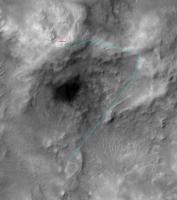
Haskin Ridge, The Eastern Route Down to the Basin |

  |
Haskin Ridge, The Eastern Route Down to the Basin |
 Oct 7 2005, 03:03 AM Oct 7 2005, 03:03 AM
Post
#16
|
|
 Senior Member  Group: Admin Posts: 4763 Joined: 15-March 05 From: Glendale, AZ Member No.: 197 |
QUOTE (jamescanvin @ Oct 7 2005, 12:23 AM) I have visions of this being a long, steep, rocky outcrop as far as the eye (pancam) can see, Well then maybe she'll wind up at the bottom a lot faster than anyone imagined  
-------------------- If Occam had heard my theory, things would be very different now.
|
 |
 
|
|
Oct 7 2005, 05:02 AM
Post
#17
|
|
|
Member Group: Members Posts: 252 Joined: 5-May 05 From: Mississippi (USA) Member No.: 379 |
QUOTE (odave @ Oct 6 2005, 11:27 AM) I'm not sure what OS you're running, but any simple "paint" program that has drawing tools for lines and text could be used. I use Paint Shop PRO for stuff like this, but the simple MS Paint program that ships with Windows is just fine. For Unix there's GIMP, but there may be something simpler available. The process isn't hard, just load the image into the program, find the line tool/text tool, and experiment! The only thing that is hard is finding the time.  Jack |
|
|
|
|
Oct 7 2005, 10:17 AM
Post
#18
|
|
|
Senior Member Group: Members Posts: 2998 Joined: 30-October 04 Member No.: 105 |
I tend to run hot-and-cold on this path to Homeplate.
This is a crop from E03-00012 that I had on my 'puter. I originally worked this up to show that the proposed path is insane and risky, but the more I look, the more I think that it might be workable, though there may be problems with dust accumulation. Here it is, with two possible paths marked, FWIW: --Bill -------------------- |
|
|
|
|
Oct 7 2005, 02:47 PM
Post
#19
|
|
|
Senior Member Group: Members Posts: 1636 Joined: 9-May 05 From: Lima, Peru Member No.: 385 |
QUOTE (Bill Harris @ Oct 7 2005, 05:17 AM) I tend to run hot-and-cold on this path to Homeplate. ... I originally worked this up to show that the proposed path is insane and risky, but the more I look, the more I think that it might be workable, though there may be problems with dust accumulation. --Bill That is good and that road is manageable. The important thing is by that way, she will be closer to many interesting sediments or rocks on the terraces. It looks like that the rovers's has gained lots of experience and knowledge of the rover's limitations after more than one year and half driving  Rodolfo |
|
|
|
|
Oct 7 2005, 02:49 PM
Post
#20
|
|
|
Senior Member Group: Members Posts: 1636 Joined: 9-May 05 From: Lima, Peru Member No.: 385 |
QUOTE (Bill Harris @ Oct 7 2005, 05:17 AM) I tend to run hot-and-cold on this path to Homeplate. ... I originally worked this up to show that the proposed path is insane and risky, but the more I look, the more I think that it might be workable, though there may be problems with dust accumulation. --Bill That is good and that road is manageable. The important thing is by that way, she will be closer to many interesting sediments or rocks on the terraces. It looks like that the rover drivers have gained lots of experience and knowledge of the rover's limitations after more than one year and half driving Rodolfo |
|
|
|
|
Oct 7 2005, 03:12 PM
Post
#21
|
||
|
Senior Member Group: Moderator Posts: 4279 Joined: 19-April 05 From: .br at .es Member No.: 253 |
QUOTE (Bill Harris @ Oct 7 2005, 12:17 PM) This is a crop from E03-00012 that I had on my 'puter. I originally worked this up to show that the proposed path is insane and risky, but the more I look, the more I think that it might be workable, though there may be problems with dust accumulation. Bill, I'm still in the phase of thinking that your proposed path (the red one) is insane and risky.  That would be a real challenge if they finally take it. I am more conservative and propose the following one:
|
|
|
|
|
|
|
Oct 7 2005, 03:27 PM
Post
#22
|
||
|
Senior Member Group: Members Posts: 1636 Joined: 9-May 05 From: Lima, Peru Member No.: 385 |
QUOTE (Tesheiner @ Oct 7 2005, 10:12 AM) That would be a real challenge if they finally take it. I am more conservative and propose the following one:
Up to now, we still don't have detail information about : 1) degree slope of the proposed path 2) kind of land (pebbles, sand, outcrop, paved, loose sand, etc.) These are important information to decide what path is possible to be as close as possible to the interest places. In the transcurse way, we will be getting these information before to select the route. What you have proposed is too far of interesting places (terraces and Ultreya Abyss). Up to now, we still don't know the 2 above important information. Rodolfo |
|
|
|
|
|
|
Oct 7 2005, 03:53 PM
Post
#23
|
|
|
Member Group: Members Posts: 236 Joined: 21-June 05 Member No.: 417 |
Some other points that have to be considered:
-The distance from Everest to Home Plate -The change of season and the position of the sun in the coming weeks/months. I believe there was an intention to park Spirit on the north slope of McCool Hill during the coming winter. Would that be before or after her visit to Home Plate? |
|
|
|
|
Oct 7 2005, 09:30 PM
Post
#24
|
|
|
Senior Member Group: Members Posts: 2998 Joined: 30-October 04 Member No.: 105 |
Tescheiner, your route is more feasible. I should have noted that mine was "The Route According to JPL, As Many Understand It".
 I've taken your route and MOC image, my tweaked version of James Canvin's color pan and put the two together. I've indicated a 15 degree slope, which really looks steep with a 3x exaggeration. Interesting to note that the downslope part of the route appears to be on a landslide area. --Bill -------------------- |
|
|
|
|
Oct 7 2005, 09:39 PM
Post
#25
|
|
 Senior Member Group: Members Posts: 2488 Joined: 17-April 05 From: Glasgow, Scotland, UK Member No.: 239 |
Bill:
Pah! 15 degrees? We don' need no' steenkeen 15 degrees! Yes, apart from the Sheriff bein' a (BONGGGGG), I have to agree! Bob Shaw -------------------- Remember: Time Flies like the wind - but Fruit Flies like bananas!
|
|
|
|
|
Oct 8 2005, 08:17 AM
Post
#26
|
||
|
Senior Member Group: Members Posts: 2821 Joined: 22-April 05 From: Ridderkerk, Netherlands Member No.: 353 |
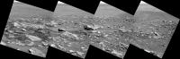
A panoramic view of part of the rocky road ahead down to the Innerbasin.
A panoramic view taken on Sol 625 with the L7 pancam. Look at the angle of the images. jvandriel
Attached thumbnail(s)
|
|
|
|
|
|
|
Oct 8 2005, 09:26 AM
Post
#27
|
||
 Senior Member Group: Members Posts: 2492 Joined: 15-January 05 From: center Italy Member No.: 150 |
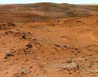
Sol621: the destination way in a 12 PanCam pictures stitch (more images are coming!):
Attached thumbnail(s)
-------------------- I always think before posting! - Marco -
|
|
|
|
|
|
|
Oct 8 2005, 07:44 PM
Post
#28
|
|
|
Senior Member Group: Moderator Posts: 4279 Joined: 19-April 05 From: .br at .es Member No.: 253 |
QUOTE (Bill Harris @ Oct 7 2005, 11:30 PM) Tescheiner, your route is more feasible. I should have noted that mine was "The Route According to JPL, As Many Understand It". I had to read again Steve Squyres' last report two more times to recognise that route on it. My first (and quick) reading gave me the (wrong) impression that his reference to "a hard right turn" was much more downslope heading ESE after the step, then just right after the step. My proposed route was made on that wrong assumption. In any case, it doesn't change my current impression that such direct path south after the step is a real challenge. If it's doable or not is something very difficult to evaluate, if ever possible, with the currently available information. |
|
|
|
|
Oct 8 2005, 09:10 PM
Post
#29
|
|
|
Member Group: Members Posts: 252 Joined: 5-May 05 From: Mississippi (USA) Member No.: 379 |
QUOTE (dilo @ Oct 8 2005, 05:26 AM) Sol621: the destination way in a 12 PanCam pictures stitch (more images are coming!): Fantastic color panorama dilo! If there are any visible seams in that graphic - I didn't see them. With your permission I will keep that image on my hard drive. It should be useful for long baseline stereo, as we drop down toward the basin. Disregarding time and resources, IMHO we can never get to many images. No one image has the complete truth. For me, the MOC orbital images of are often difficult to correlate with the "ground truth" images. I created a long baseline animated gif of the NE basin, and then I spent hours trying to relate what I saw in the flicker, with what I saw in the MOC image. I did much of the work for my own curiosity, but in case anyone is interested, I will post my material here. Anyone trying this should probably have all three images open in browser windows for simplfied comparisons. Comparison of Orbital and "Ground Truth" Imagery for NE Basin 1st: Image Overview of Basin File size 365 kB I added some green lines to this image to draw your attention to some ridge-like features that are visible in all three images. The green lines are offset, and run parallel to the ridge features. The green lines do not cover the ridge features. MOC-OverviewBasin-with-lines.gif ---------- 2nd: SOL605 NAVCAM Crop of NE-Basin File size 344 kB I also added some green lines to this image to draw your attention to the ridge-like features that are visible in all three images. These green lines are also offset, and run parallel to the ridge features. The green lines do not cover the ridge features. 605-NAV-crop-NE-Basin-with-lines.gif --------- 3rd: Animated GIF of NE Basin File size 571 kB 582-605-NAV-Crop-NE-Basin-flicker.gif ---------- I really like this animated gif. I managed to achieve some 3D effects with Ramon Hill, at a distance of about a kilometer. You should not consider my flicker gif's to be scientifically accurate. The separation of long baseline images is unknown, and I don't pretend to understand what I am doing when I register the images. Since I don't fully understand the process, I can only act on the results.  Jack |
|
|
|
|
Oct 9 2005, 12:36 AM
Post
#30
|
|
|
Member Group: Members Posts: 153 Joined: 11-December 04 Member No.: 120 |
QUOTE (stewjack @ Oct 8 2005, 09:10 PM) 8.4 on the Richter scale? 
|
|
|
|
|

|
Lo-Fi Version | Time is now: 28th April 2024 - 06:00 PM |
|
RULES AND GUIDELINES Please read the Forum Rules and Guidelines before posting. IMAGE COPYRIGHT |
OPINIONS AND MODERATION Opinions expressed on UnmannedSpaceflight.com are those of the individual posters and do not necessarily reflect the opinions of UnmannedSpaceflight.com or The Planetary Society. The all-volunteer UnmannedSpaceflight.com moderation team is wholly independent of The Planetary Society. The Planetary Society has no influence over decisions made by the UnmannedSpaceflight.com moderators. |
SUPPORT THE FORUM Unmannedspaceflight.com is funded by the Planetary Society. Please consider supporting our work and many other projects by donating to the Society or becoming a member. |
|