

MSL "Drive, drive, drive" toward Glenelg, The scientists (mostly) get the keys - sols 38-56 |

  |
MSL "Drive, drive, drive" toward Glenelg, The scientists (mostly) get the keys - sols 38-56 |
 Sep 28 2012, 01:06 AM Sep 28 2012, 01:06 AM
Post
#294
|
|
|
Senior Member  Group: Members Posts: 2079 Joined: 13-February 10 From: Ontario Member No.: 5221 |
And the first where the liquid was water too.
|
 |
 
|
|
Sep 28 2012, 05:25 AM
Post
#295
|
|
|
Junior Member Group: Members Posts: 94 Joined: 11-August 12 Member No.: 6536 |
Some of the geologists deserve a few beers, because what the rover found is pretty much what they predicted was there based on orbiter images.(Anderson + Bell, 2010, Geologic mapping and characterization of Gale Crater and implications for its potential as a Mars Science Laboratory landing site )
When that stuff finally gets drilled and fed to the lab there should be a really interesting story to tell about the chemistry of the water and maybe even organics. It looks a lot different from the Meridiani material, so maybe the water here was less acidic. If water was flowing down into this area, shouldn't there be a dried up lake bed somewhere? Like maybe at Glenelg? |
|
|
|
|
Sep 28 2012, 06:19 AM
Post
#296
|
|
 Member Group: Members Posts: 691 Joined: 21-December 07 From: Clatskanie, Oregon Member No.: 3988 |
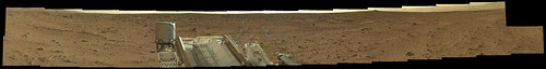
Here is a thumbnail version of the Sol-50 panorama.
|
|
|
|
|
Sep 28 2012, 11:10 AM
Post
#297
|
|
 Member Group: Members Posts: 547 Joined: 1-May 06 From: Scotland (Ecosse, Escocia) Member No.: 759 |
QUOTE (jmknapp @ Sep 28 2012, 01:03 AM)  If they're looking for a warmer, wetter planet, they're getting hottah. Love it! Especially in an upper class English accent... |
|
|
|
|
Sep 28 2012, 11:22 AM
Post
#298
|
|
|
Solar System Cartographer Group: Members Posts: 10146 Joined: 5-April 05 From: Canada Member No.: 227 |
Looks like no drive on sol 51, but some arm flexing for testing sample delivery instead. Should be a drive today (from Scott's tweet).
Phil -------------------- ... because the Solar System ain't gonna map itself.
Also to be found posting similar content on https://mastodon.social/@PhilStooke NOTE: everything created by me which I post on UMSF is considered to be in the public domain (NOT CC, public domain) |
|
|
|
| Guest_fthurber_* |
Sep 28 2012, 01:41 PM
Post
#299
|
|
Guests |
QUOTE (climber @ Sep 27 2012, 08:10 PM) So, after Huygens, that's the second time we landed in a stream/river or whatever it was. I seem to remember that the plan was to land Mars Pathfinder in an outwash / alluvial area but I don't remember Pathfinder / Sojourner detecting any waterborne sediments except to note that the rocks were sightly tilted in direction. |
|
|
|
|
Sep 28 2012, 01:47 PM
Post
#300
|
|
 Senior Member Group: Members Posts: 1619 Joined: 12-February 06 From: Bergerac - FR Member No.: 678 |
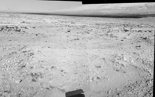
And 100mm "thumbail" pan :

-------------------- |
|
|
|
|
Sep 28 2012, 01:59 PM
Post
#301
|
|
|
Solar System Cartographer Group: Members Posts: 10146 Joined: 5-April 05 From: Canada Member No.: 227 |
Ant's pan shows there are some small drifts slightly northwest of the current position. Possibly big enough for the sampling tests.
Phil -------------------- ... because the Solar System ain't gonna map itself.
Also to be found posting similar content on https://mastodon.social/@PhilStooke NOTE: everything created by me which I post on UMSF is considered to be in the public domain (NOT CC, public domain) |
|
|
|
|
Sep 28 2012, 03:17 PM
Post
#302
|
|
|
Member Group: Members Posts: 813 Joined: 29-December 05 From: NE Oh, USA Member No.: 627 |
Wondering if they may want to get closer to Glenelg before they scoop soil. A vantage point that would allow them to do remote sensing with cameras and CHEMCAM while SAM and CHEMIN process the soil samples.
That would also allow them to do planning for the first sampling campaign at Glenelg. Craig |
|
|
|
|
Sep 28 2012, 03:31 PM
Post
#303
|
|
|
Solar System Cartographer Group: Members Posts: 10146 Joined: 5-April 05 From: Canada Member No.: 227 |
Good point!
Phil -------------------- ... because the Solar System ain't gonna map itself.
Also to be found posting similar content on https://mastodon.social/@PhilStooke NOTE: everything created by me which I post on UMSF is considered to be in the public domain (NOT CC, public domain) |
|
|
|
|
Sep 28 2012, 04:33 PM
Post
#304
|
|
 Senior Member Group: Members Posts: 3419 Joined: 9-February 04 From: Minneapolis, MN, USA Member No.: 15 |
QUOTE (fthurber @ Sep 28 2012, 08:41 AM) I seem to remember that the plan was to land Mars Pathfinder in an outwash / alluvial area but I don't remember Pathfinder / Sojourner detecting any waterborne sediments except to note that the rocks were sightly tilted in direction. Viking 1 was also targeted to an outflow channel area (where it was thought at the time that there may be a remnant water table near enough to the surface to support microbial life). Unfortunately, these locations have been dry for megayears, and the rocks in the area were washed in from a great variety of locations, making it nearly impossible to judge their geologic context. -the other Doug -------------------- The trouble ain't that there is too many fools, but that the lightning ain't distributed right. -Mark Twain
|
|
|
|
| Guest_fthurber_* |
Sep 28 2012, 04:52 PM
Post
#305
|
|
Guests |
QUOTE (djellison @ Sep 27 2012, 03:14 PM) Your options basically are 'SAM may or may not have detected methane'. Isn't that fairly obvious? If some startling revelation were found, they would have a press conference about it when they were confident in the results. If there were something up with SAM they would ( as with REMS ) let us know. No news isn't bad news or good news. True; it is hard to make a guess based on no results so please take what I say below with a grain of salt. As far as the methane results, I think there are 3 possible outcomes: no methane, methane detected, or an instrument problem. I would think no-methane would be the most likely outcome, but in that case I would think that the team would have reported these results. That suggests (and only suggests) the other intriguing possibilities. My guess is that methane was detected but its source cannot be positively identified yet. Remember that when SAM was first started, the turbomolecular pump shut down due to high current draw and very high methane readings were recorded. As you know this was caused by Florida air trapped in the TLS. I suspect the team is being very cautious this time, and they may be working to concentrate the Martian air....but I wish they would give us some preliminary results. Sorry to bother everyone with these details, but it seems to me, at least, that the methane results could be very significant, i.e. whether the methane has a biological origin or not. |
|
|
|
| Guest_fthurber_* |
Sep 28 2012, 05:01 PM
Post
#306
|
|
Guests |
QUOTE (belleraphon1 @ Sep 28 2012, 11:17 AM) Wondering if they may want to get closer to Glenelg before they scoop soil. Craig I wonder if the most interesting soil to scoop would be the cementing matrix that had eroded off some exposed conglomerate. Maybe they could pick up some carbonates. Then again it might be a heterogeneous mix of lots of different minerals; that might be hard to sort out in ChemMin. I am surprised that they did not do a ChemCam raster scan of Hottah. Maybe they could get have gotten lucky and flashed off some of the cementing mineral. |
|
|
|
|
Sep 28 2012, 05:26 PM
Post
#307
|
|
 Member Group: Members Posts: 710 Joined: 28-September 04 Member No.: 99 |
Sol 52: More homeplaty rocks.
|
|
|
|
|
Sep 28 2012, 05:40 PM
Post
#308
|
|
 Senior Member Group: Moderator Posts: 3431 Joined: 11-August 04 From: USA Member No.: 98 |
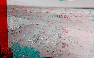
Yes, I would say we're closer on sol 52! Like, right on the boundary. (Anaglyph version strongly recommended.)
|
|
|
|
|

|
Lo-Fi Version | Time is now: 20th April 2024 - 01:47 AM |
|
RULES AND GUIDELINES Please read the Forum Rules and Guidelines before posting. IMAGE COPYRIGHT |
OPINIONS AND MODERATION Opinions expressed on UnmannedSpaceflight.com are those of the individual posters and do not necessarily reflect the opinions of UnmannedSpaceflight.com or The Planetary Society. The all-volunteer UnmannedSpaceflight.com moderation team is wholly independent of The Planetary Society. The Planetary Society has no influence over decisions made by the UnmannedSpaceflight.com moderators. |
SUPPORT THE FORUM Unmannedspaceflight.com is funded by the Planetary Society. Please consider supporting our work and many other projects by donating to the Society or becoming a member. |
|


