Journey to Mt Sharp - Part 5A: Pahrump Hills, Sites 42-45, Sol 753-923, Sep 18, 2014-March 12, 2015 |

  |
Journey to Mt Sharp - Part 5A: Pahrump Hills, Sites 42-45, Sol 753-923, Sep 18, 2014-March 12, 2015 |
 Apr 19 2015, 06:11 PM Apr 19 2015, 06:11 PM
Post
#541
|
||
 Member  Group: Members Posts: 809 Joined: 3-June 04 From: Brittany, France Member No.: 79 |
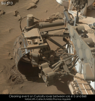
I showed my animation of MAHLI selfies to Ashwin Vasavada and he identified a cleaning event on the rover between sols 613 and 868.
So I made a close-up animation on the device with a checkerboard pattern where the cleaning is particularly visible:
Here is the high resolution version. -------------------- |
|
 |
 
|
|
|
Apr 20 2015, 04:23 AM
Post
#542
|
|
 Senior Member Group: Members Posts: 2228 Joined: 1-December 04 From: Marble Falls, Texas, USA Member No.: 116 |
Gerald:
Thank you very much. You're awesome! I am especially grateful for your examples showing me where to look to find the spectral data on my own.  Agate was a long shot, but this target remains a very interesting rock, nevertheless. QUOTE (Aldebaran @ Apr 19 2015, 05:52 AM)  ... However, It's deceptive to try to form conclusions like this from visual appearance alone. Aldebaran: I didn't recall Spirit finding chert-like deposits, but I do recall her scraping up some opaline material with the dragging wheel. For the record, that's why I said , "based on this image alone, one can't be certain," and why I was hoping to find some spectral data. While a lot of cryptocrystalline quartz like chalcedony, chert, and agate occurs in volcanic amygdules and lithophysae, I suspect an even greater mass of these minerals have been deposited in sedimentary rocks on Earth. -------------------- ...Tom
I'm not a Space Fan, I'm a Space Exploration Enthusiast. |
|
|
|
|
Apr 20 2015, 06:43 AM
Post
#543
|
|
|
Senior Member Group: Members Posts: 1043 Joined: 17-February 09 Member No.: 4605 |
Chert and agate are also associated with large impact structures so given the environment it was a reasonable suggestion.
|
|
|
|
|
Jun 27 2015, 01:37 PM
Post
#544
|
||
|
Senior Member Group: Members Posts: 2816 Joined: 22-April 05 From: Ridderkerk, Netherlands Member No.: 353 |
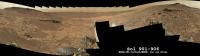
The last images are down, Debayered and stitched.
Here is the complete panoramic view taken on Sol 901 and Sol 906. Jan van Driel
|
|
|
|
|
|
|
Nov 16 2015, 08:53 PM
Post
#545
|
||
 Member Group: Members Posts: 244 Joined: 2-March 15 Member No.: 7408 |
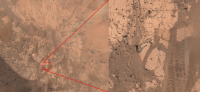
In another thread, I was talking about the work I was doing with combining imagery from the science cameras with 3-D point clouds generated from engineering camera data. Data from Site 45 became available with the last PDS release, and I've created a map of the area around Site 45 / 160 by making a plan projection of the color point cloud I've been working on.
First, let me provide some context for this "map". Here's the location on the map provided at the Analyst's Notebook: 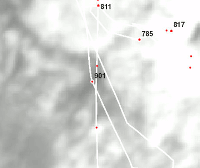 And here's the location on the map provided at http://curiositymsl.com/rovermap1.html 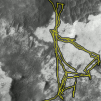 (the rover path appears to be a bit off on that map) The image is very large. The scale is something like 5 mm per pixel. Here's a preview of the full resolution:
The quality resolution and the image resolution are independent in the image. The quality resolution is dependent on the density of the point cloud in any given location. Most of the point cloud data came from NAVCAM data products acquired at Site 45 / 160, so for the most part, the quality is best closest to that spot. The area blocked by rover structure obviously comes from NAVCAM data acquired at other locations, so the parts nearest to the middle are actually much lower quality. Most areas near the edge of the image are similarly low quality. Some areas are simply a blur because they were never in line-of-sight in any of the NAVCAM data I used or because they were too smooth to do photogrammetry for stereo data. I did not make any attempt to balance the colors between images acquired under different lighting conditions, so the map is hard to interpret when zoomed out, due to the transitions between source imagery. Fortunately, the accuracy of the stereo data and the CAHV(OR) model data are so good that transitions between source imaging events produce lighting changes but do not introduce any noticeable misalignment. The image is 5773x4851 and can be downloaded as a JPEG (7 MiB) or as a PNG (50 MiB). |
|
|
|
|
|
|
Jun 14 2016, 11:04 PM
Post
#546
|
|
 Senior Member Group: Members Posts: 1624 Joined: 5-March 05 From: Boulder, CO Member No.: 184 |
Here is the Book Cliffs area in VR as done by Scott Manley (pointed out to me by Sean):
https://www.youtube.com/watch?v=e76uBfWxD74 This also looks good in an Oculus Rift as we are developing with SOS-Explorer. QUOTE (Gerald @ Nov 18 2014, 10:08 PM) Partial Sol 812 NRB pan, after driving to Book Cliffs:
-------------------- Steve [ my home page and planetary maps page ]
|
|
|
|
|
Jun 15 2016, 12:50 PM
Post
#547
|
|
|
Junior Member Group: Members Posts: 42 Joined: 19-October 12 Member No.: 6719 |
QUOTE (CosmicRocker @ Apr 20 2015, 04:23 AM) Gerald: Thank you very much. You're awesome! I am especially grateful for your examples showing me where to look to find the spectral data on my own. Agate was a long shot, but this target remains a very interesting rock, nevertheless. Aldebaran: I didn't recall Spirit finding chert-like deposits, but I do recall her scraping up some opaline material with the dragging wheel. For the record, that's why I said , "based on this image alone, one can't be certain," and why I was hoping to find some spectral data. While a lot of cryptocrystalline quartz like chalcedony, chert, and agate occurs in volcanic amygdules and lithophysae, I suspect an even greater mass of these minerals have been deposited in sedimentary rocks on Earth. Chert has some interesting preservation properties and John Grotzinger has published papers and blogs (http://mars.nasa.gov/blogs/index.cfm?FuseAction=ShowBlogs&BlogsID=283) on chert so finding it in Gale would be rather exciting. |
|
|
|
|

|
Lo-Fi Version | Time is now: 18th April 2024 - 02:53 AM |
|
RULES AND GUIDELINES Please read the Forum Rules and Guidelines before posting. IMAGE COPYRIGHT |
OPINIONS AND MODERATION Opinions expressed on UnmannedSpaceflight.com are those of the individual posters and do not necessarily reflect the opinions of UnmannedSpaceflight.com or The Planetary Society. The all-volunteer UnmannedSpaceflight.com moderation team is wholly independent of The Planetary Society. The Planetary Society has no influence over decisions made by the UnmannedSpaceflight.com moderators. |
SUPPORT THE FORUM Unmannedspaceflight.com is funded by the Planetary Society. Please consider supporting our work and many other projects by donating to the Society or becoming a member. |
|