Titan's Equatorial Sand Seas |

  |
Titan's Equatorial Sand Seas |
 May 12 2007, 08:01 PM May 12 2007, 08:01 PM
Post
#16
|
|
|
Senior Member  Group: Members Posts: 3516 Joined: 4-November 05 From: North Wales Member No.: 542 |
[quote name='rlorenz' date='May 12 2007, 04:40 PM' post='90040']
Titan flagship study (presentation to OPAG should go up on the OPAG website in due course) A b&w printout thereof is already on my coffee table. It's a lot easier to read than the Europa one if, like me, one isn't well versed in the latest management and planning jargon. quote: I'm barely managing to read all the posts.....  Thanks again for contributing here. Thanks again for contributing here.
|
 |
 
|
|
May 13 2007, 09:23 PM
Post
#17
|
|
|
Junior Member Group: Members Posts: 40 Joined: 11-November 05 Member No.: 550 |
I stumbled a publication (PDF) entitled: 'Comparative Sediment Transport By Flowing Liquid on Earth, Mars and Titan: Synthesis Of Theory And Observations'
It could be of some interest, although you probably already know about it. However, it's the first time I have seen it.... |
|
|
|
|
May 13 2007, 09:28 PM
Post
#18
|
|
|
Junior Member Group: Members Posts: 40 Joined: 11-November 05 Member No.: 550 |
I stumbled upon a publication, rather.
|
|
|
|
|
May 13 2007, 10:28 PM
Post
#19
|
|
 Member Group: Members Posts: 723 Joined: 13-June 04 Member No.: 82 |
^link?
Bill |
|
|
|
|
May 13 2007, 11:00 PM
Post
#20
|
|
|
Junior Member Group: Members Posts: 40 Joined: 11-November 05 Member No.: 550 |
http://www.lpi.usra.edu/meetings/lpsc2007/pdf/2222.pdf
I'm new to all this linking stuff...let's see if I got it right.... |
|
|
|
|
May 14 2007, 03:00 PM
Post
#21
|
|||||||||||
 Senior Member Group: Moderator Posts: 2785 Joined: 10-November 06 From: Pasadena, CA Member No.: 1345 |
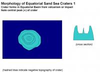
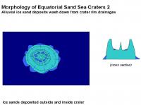
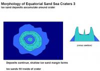
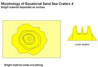
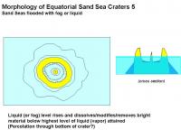
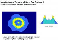
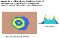
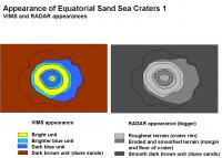
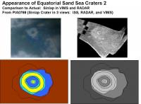
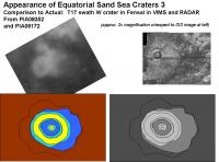
Ive put together a hypothetical sequence that could explain the RADAR and VIMS appearance of the craters observed in the Equatorial Sand Seas. (Craters such as Sinlap, the T17 swath crater in W Fensal, and Guabonito). This sequence also explains the puzzling appearance of the bright material which highlights the crater rims and central peaks.
1. Crater forms, either before or after the Sand Sea basin forms or is partially filled in.. 2. Water ice sand erodes on outside of crater, forming a debris apron or ice sand margin. 3. Bright material is deposited. 4. Liquid or fog percolates up to a set topographic level at the crater. All bright material below this line (highest sea level) is dissolved/modified/washed away. 5. The liquid (fog) level retreats, leaving crater high and dry and revealing previous units. 6. Mobile dark brown dune sands deposited on W side, but dont fill in downwind (E) in the wind shadow of the crater. Here are some examples of what we would expect to observe from this scenario, compared to actual VIMS and RADAR images:
This nicely explains the bright material deposited on the rim of the crater, but not on the blue ice sand margins (in some of the craters like Sinlap). It also explains the bright deposit on the central peaks of Sinlap, as well as on the central peak of the crater-shaped feature NE of the Huygens Landing Site (seen in ISS).. The key to this sequence is that the bright material was deposited BEFORE the last major sea level rise. It is possible that each item in the sequence is periodic, rather than a one time deal. So the deposition of bright material is episodic and rare, floods are less rare, and dune sands move quite often. The bright/dark line around the Equatorial Dune Seas are fixed by the last major sea level height attained in that basin after bright material was deposited. Craters that formed environments that were eventually deeply flooded will have a significant light blue and dark blue sand ice margin that extends outside the brightest material deposit (especially to the W). They will have a bulls-eye pattern in VIMS. Those craters that formed in areas that were only slightly covered in liquid at its highest point will have a very small blue ice sand margin that extends beyond the bright material these will have a very asymmetric look in VIMS (strong trailing to the E). Some craters were never inundated and thus would only have bright material covering the entire crater complex these may not show up by VIMS, only by RADAR. Craters that formed in what was eventually a deep liquid environments include Sinlap, the Western T17 RADAR swath crater in Fensal, and Guabonito. Craters that fomed in an enviroment that was eventually shallowly covered in liquid include Minerva, and the crater(?) that is on the W tip of Quivra (seen in the T25 RADAR swath) Craters that formed in environments that were never inundated include the crater on the N end of Shikoku Faculae. (not obvious in ISS, but seen in RADAR). By this analogy, Fensal is deeper than Aztlan. And Shangri-La nearest Xanadu is deep (subduction?) and Shangri La is very shallow near its contact with Adiri. In general, areas with steep shorelines (highest level attained after the last bright stuff deposition event) will have fewer indentations and have a smoother light/dark border (i.e. Xanadu). Areas with shallow shores with relative highest topography closest to highest sea level height will have very jagged and irregular bright/dark borders (ancient bright stuff/liquid shorelines). From this we would predict that average elevation of Adiri is very close to the highest attained level. It may be an area that has been gently upwarped to a level just slightly above the highest attained sea level in Shangri-La basin after the last bright stuff deposition event. The bright island at the Huygens Landing Site sits just above the level of the highest level of liquid attained in Shangri-La after the last bright stuff deposition event. The bright/dark contact line of the highland sits at the highest level of liquid attained in the Shangri-La basin. In the channel some of the sand bars have bright material deposited on them. This should allow us to link the two units. The bright stuff on the sand bars would also be just poking above the highest level of liquid attained in the Shangri-La basin after the last bright stuff deposition event.. The analogy of the Great Basin of North America, painted white, and then flooded with a Glacial Lake Bonneville amount of turpentine and then drained seems pretty close. (Possibly very close chemically). -Mike -------------------- Some higher resolution images available at my photostream: http://www.flickr.com/photos/31678681@N07/
|
||||||||||
|
|
|
||||||||||
|
May 14 2007, 06:30 PM
Post
#22
|
||
 SewingMachine Group: Members Posts: 316 Joined: 27-September 05 From: Seattle Member No.: 510 |
This seems like as good a place as any to deposit this experiment, rather than resurrecting the old map thread. This is a largely cosmetic retooling of the Fensal-Aztlan portion of the global map with the currently released SAR swaths overlain (T3. T13, T16, T17, T25). The resolution here is barely decent enough to make out the dunes in places, but it gives a pretty good indication of what sort of mapping products will be possible from these growing datasets.
-------------------- ...if you don't like my melody, i'll sing it in a major key, i'll sing it very happily. heavens! everybody's all aboard? let's take it back to that minor chord...
Exploitcorporations on Flickr (in progress) : https://www.flickr.com/photos/135024395@N07/ |
|
|
|
|
|
|
May 14 2007, 06:40 PM
Post
#23
|
|
|
Senior Member Group: Moderator Posts: 2785 Joined: 10-November 06 From: Pasadena, CA Member No.: 1345 |
Wow! Thank you, Exploitcorporations!
(Looks like I muffed the image of the VIMS inset of the T17 W Fensal crater. I thought it was the crater at the north nortwest end of your image (it just got missed by the T17 swath, although the southern debris apron might've gotten picked up). I should have grabbed the image of the crater much further to the W. It's interesting how those two craters look fairly similar with a slight "wing" off the NW part of the crater.) I would predict that when this "bulls-eye crater" is imaged by RADAR SAR, that it will look very similar to the T17 W Fensal crater, and to Sinlap crater (but possibly with an even bigger apron). -Mike -------------------- Some higher resolution images available at my photostream: http://www.flickr.com/photos/31678681@N07/
|
|
|
|
|
May 14 2007, 07:06 PM
Post
#24
|
|
|
Rover Driver Group: Members Posts: 1015 Joined: 4-March 04 Member No.: 47 |
simply...wow! amazing how sharp it is!
|
|
|
|
|
May 14 2007, 07:44 PM
Post
#25
|
|
 Senior Member Group: Moderator Posts: 3231 Joined: 11-February 04 From: Tucson, AZ Member No.: 23 |
QUOTE (Juramike @ May 14 2007, 11:40 AM)  I would predict that when this "bulls-eye crater" is imaged by RADAR SAR, that it will look very similar to the T17 W Fensal crater, and to Sinlap crater (but possibly with an even bigger apron). -Mike What crater? Are you talking about the feature that you thought was Ksa? -------------------- &@^^!% Jim! I'm a geologist, not a physicist!
The Gish Bar Times - A Blog all about Jupiter's Moon Io |
|
|
|
|
May 14 2007, 08:22 PM
Post
#26
|
||
|
Senior Member Group: Moderator Posts: 2785 Joined: 10-November 06 From: Pasadena, CA Member No.: 1345 |
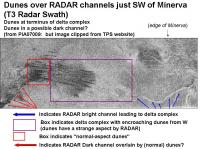
QUOTE (rlorenz @ May 12 2007, 11:40 AM) Wish I had as much time to spend on analysing the Cassini data as you do! (I think when the boss-man finds out, I'm doomed!  ) )But thank in advance for all your suggestions, input , and helpful guidance when you are able! QUOTE (ngunn @ May 12 2007, 03:35 PM) However it's not clear that the dark channel was continuous at this point until being buried by the dunes. The perfect "smoking gun" SAR RADAR image would have a N or S flowing channel which is either cut by or cuts into the E-->W flowing dune features. I haven't found this yet. [Odd, I'm kinda suspecting that most tectonic features seem to trend E-W in the equatorial zone]. Based on Dr. Lorenz's suggestion, I found an interesting are to the SW of Minerva that consists of a bright stream (pretty much originating at the outer wall of the crater) that feeds into a delta complex that is being encroached upon by dunes. (Or is the delta encroaching the dune field? based on the sharpness of the dunes lines at the E edge, I think it is the dunes encroaching upon the delta). These dunes have a funky look. Further to the SW it appears to be a channel with dunes lying across a RADAR-dark channel. Here is the annotated image:
Is the RADAR-dark channel continuous (in this location or the other locations)? I really can't say, but I would strongly speculate that the dunes are lying on top of a continuous dark channel. -Mike P.S. "Anabranch" is my new word for the day! -------------------- Some higher resolution images available at my photostream: http://www.flickr.com/photos/31678681@N07/
|
|
|
|
|
|
|
May 14 2007, 09:15 PM
Post
#27
|
||
|
Senior Member Group: Moderator Posts: 2785 Joined: 10-November 06 From: Pasadena, CA Member No.: 1345 |
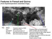
QUOTE (volcanopele @ May 14 2007, 03:44 PM) What crater? Are you talking about the feature that you thought was Ksa? The RADAR image in my post is of Ksa (I got that one right). The ISS image (which I thought was Ksa, but it is not) is of the feature at center top mentioned in the second image of your previous post. I've indicated some of these features in a section clipped from the wonderful mosaic posted today (thanks, again!) by Exploitcorporations:
In Figure 6 of the Soderblom et al paper "Corellations between Cassini VIMS spectra and RADAR SAR images: Implications fo Titan's surface composition and the character of the Huygens probe landing site", this feature in the VIMS processing to make Figure 6 has a very small blue ring around it. (I'd also argue that his larger buddy to the E also looks similar). I suspect that this is a very low-lying crater (old?) that when eventually imaged by RADAR will look like a miniature version of Minerva. (Mini-Minerva?). To the SW is an interesting feature that also has a blue tail in VIMS, but seems relatively dim by ISS. Could this be another type of feature (cryovolcano?) or a very low-lying crater that did not get a large dusting of bright material or suffered only partial scrubbing? Can't wait for more RADAR! -Mike -------------------- Some higher resolution images available at my photostream: http://www.flickr.com/photos/31678681@N07/
|
|
|
|
|
|
|
May 14 2007, 09:29 PM
Post
#28
|
|
|
Senior Member Group: Moderator Posts: 3231 Joined: 11-February 04 From: Tucson, AZ Member No.: 23 |
hmm, I suspect that the feature you thought was Ksa is actually a Ganesa-type cryovolcano, with a flow to the east and north...
-------------------- &@^^!% Jim! I'm a geologist, not a physicist!
The Gish Bar Times - A Blog all about Jupiter's Moon Io |
|
|
|
|
May 14 2007, 09:40 PM
Post
#29
|
|
|
Senior Member Group: Moderator Posts: 2785 Joined: 10-November 06 From: Pasadena, CA Member No.: 1345 |
Are there easy ways to discern between a cryovolcano and an impact feature?
-Mike -------------------- Some higher resolution images available at my photostream: http://www.flickr.com/photos/31678681@N07/
|
|
|
|
|
May 14 2007, 09:56 PM
Post
#30
|
|
|
Senior Member Group: Moderator Posts: 3231 Joined: 11-February 04 From: Tucson, AZ Member No.: 23 |
Well, it would be nice if it erupted. That would make it much easier
 To be honest, it would require a good ISS/VIMS observation of Ganesa to determine what a Ganesa-type feature looks like in VIMS and ISS images. My basis for saying, at the very least, to hold off on declaring that feature a crater, is that while it is circular, there are a number of other ways to form circular features, like the Ganesa-type pancake dome. The apparent flow to the east and north and the fact that it doesn't match the appearance of other dark terrain craters (Guabonito, Sinlap, Velas, and the guy north of Adiri), with very dark interiors, intermediate albedo crater walls, and bright raised rims/ejecta blankets also suggest that we should serious consider a cryovolcanic origin for this feature. But, I'll admit the evidence is about as conclusive as Tortola Facula (the VIMS snail from Ta) being a cryovolcano. -------------------- &@^^!% Jim! I'm a geologist, not a physicist!
The Gish Bar Times - A Blog all about Jupiter's Moon Io |
|
|
|
|

|
Lo-Fi Version | Time is now: 19th April 2024 - 05:14 PM |
|
RULES AND GUIDELINES Please read the Forum Rules and Guidelines before posting. IMAGE COPYRIGHT |
OPINIONS AND MODERATION Opinions expressed on UnmannedSpaceflight.com are those of the individual posters and do not necessarily reflect the opinions of UnmannedSpaceflight.com or The Planetary Society. The all-volunteer UnmannedSpaceflight.com moderation team is wholly independent of The Planetary Society. The Planetary Society has no influence over decisions made by the UnmannedSpaceflight.com moderators. |
SUPPORT THE FORUM Unmannedspaceflight.com is funded by the Planetary Society. Please consider supporting our work and many other projects by donating to the Society or becoming a member. |
|