Rev 201 and T98, Looking for changes in Ontario Lacus |

  |
Rev 201 and T98, Looking for changes in Ontario Lacus |
 Feb 9 2014, 02:21 PM Feb 9 2014, 02:21 PM
Post
#16
|
|
 Member  Group: Members Posts: 610 Joined: 23-February 07 From: Occasionally in Columbia, MD Member No.: 1764 |
QUOTE (ngunn @ Feb 6 2014, 03:45 AM)  I may be wrong but in general I doubt that authors will be willing to discuss their work here before presenting at the conference. Well, you're right in that sometimes people prefer to keep work close until published or presented. Had we observed a whirlpool or something, then we'd have likely submitted to Science or Nature and been very up tight about it. But we just saw a strait (which has the potential to generate whirlpools) and have now submitted a paper to Icarus (note that some of the numbers have been revised since the abstract, which was written over a month ago, and the paper reflects a wider set of contributors). The work has been and is being presented at internal meetings too. The paper, and the bathymetry 'dataset' are at http://www.lpl.arizona.edu/~rlorenz/titansea.html |
 |
 
|
|
Feb 9 2014, 02:30 PM
Post
#17
|
|
|
Member Group: Members Posts: 610 Joined: 23-February 07 From: Occasionally in Columbia, MD Member No.: 1764 |
QUOTE (antipode @ Feb 5 2014, 08:40 PM) multiple islands separated by narrow channels all the way to the 'mainland'. Surely these constrictions have the potential to generate even bigger tidal races? No. For small overall conductance across the isthmus, there is a fixed hydraulic head (sea level difference) driving the flow. So small and/or shallow channels will have more friction, and so slower velocities. When the conductance gets big enough, there will be enough volume flow that the driving head is reduced (since the liquid doesnt pile up, just goes through). So in terms of dissipation (flow amount times friction) there is actually an optimum amount of conductance. When the conductance is very large, then lots of liquid goes through, but slowly. When you have multiple conductances in parallel, the largest one dominates - so the main strait is shorting out the narrow labyrinth. It may help to think in terms of electrical analogies : the tide overall is like an ideal voltage source (indeed, it's not called a tidal potential for nothing) QUOTE Also - has the 'mare' on the equatorside of the southern Kraken basin been named? As I understand it, a proposal has been made (I'm not sure the basin merits a separate name myself) but nothing official has happened as of yet. |
|
|
|
|
Feb 9 2014, 11:55 PM
Post
#18
|
|
 Senior Member Group: Moderator Posts: 3232 Joined: 11-February 04 From: Tucson, AZ Member No.: 23 |
QUOTE (rlorenz @ Feb 9 2014, 07:30 AM) As I understand it, a proposal has been made (I'm not sure the basin merits a separate name myself) but nothing official has happened as of yet. Yeah, not sure any more names are needed, it's all just one big sea according to VIMS and ISS data (some of the HiSAR data suggest far southern Kraken Mare isn't connected to the rest of it, but I don't believe that based on the rest of the RADAR/ISS/VIMS comparisons... -------------------- &@^^!% Jim! I'm a geologist, not a physicist!
The Gish Bar Times - A Blog all about Jupiter's Moon Io |
|
|
|
|
Feb 10 2014, 01:02 PM
Post
#19
|
|
|
Senior Member Group: Members Posts: 3516 Joined: 4-November 05 From: North Wales Member No.: 542 |
QUOTE (rlorenz @ Feb 9 2014, 02:21 PM) The paper, and the bathymetry 'dataset' are at http://www.lpl.arizona.edu/~rlorenz/titansea.html Thanks for sharing that here, it's a great read. It's interesting that you make a comparison with the Baltic Sea. We often see Kraken compared with the Caspian Sea for size, but I've long thought the Baltic a much better comparison. Not only is the total area about right but it also has a sprawling, branching shape with many islands, plus a similar northerly location. |
|
|
|
|
Feb 10 2014, 09:31 PM
Post
#20
|
|||
|
Member Group: Members Posts: 699 Joined: 1-April 08 From: Minnesota ! Member No.: 4081 |
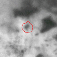
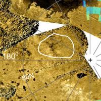
Ian R’s nifty enhanced image from T98 shows a prominent dark albedo near the north pole (NP) of Titan that is not a “full lake” in the HiSAR of the area of 2007 (T25). One wonders if we are seeing an actual change (due to seasonal fluvial mechanisms) vs an artifact due to limitation of resolution and phase angle. The area in question is circled in red in the left image and in white in the right image below. On the left are Ian R's image and the incredible recent VIMS image http://www.ciclops.org/view_media/38696/Ti...kes-Salt-Flats; on the right is the N Polar SAR image provided by Lorenz here. http://www.jhuapl.edu/newscenter/pressrele...0515_image3.asp
|
||
|
|
|
||
|
Feb 27 2014, 04:30 PM
Post
#21
|
|
 Lord Of The Uranian Rings Group: Members Posts: 798 Joined: 18-July 05 From: Plymouth, UK Member No.: 437 |
Well, I guess it must be considered a 'full' lake now, having received the official name of 'Müggel Lacus' (as opposed to Lacuna).
-------------------- |
|
|
|
|
Mar 2 2014, 07:34 AM
Post
#22
|
||
|
Member Group: Members Posts: 699 Joined: 1-April 08 From: Minnesota ! Member No.: 4081 |
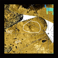
The full lake designation and location map appeared in the LPSC abstract http://www.hou.usra.edu/meetings/lpsc2014/pdf/2341.pdf but it appears to be misplaced on the polar lake location map? The ISS WAC and VIMS images from 9-12-2013 align better with the radar map location. If fact VIMS shows lots of bright signal (?evaporite) within and around Muggel lacus. This and the possibility that radar is showing the bottom of the lake (from T25) suggests the lake is probably shallow and might be a good place to check for seasonal changes.
|
|
|
|
|
|
|

|
Lo-Fi Version | Time is now: 24th April 2024 - 02:33 AM |
|
RULES AND GUIDELINES Please read the Forum Rules and Guidelines before posting. IMAGE COPYRIGHT |
OPINIONS AND MODERATION Opinions expressed on UnmannedSpaceflight.com are those of the individual posters and do not necessarily reflect the opinions of UnmannedSpaceflight.com or The Planetary Society. The all-volunteer UnmannedSpaceflight.com moderation team is wholly independent of The Planetary Society. The Planetary Society has no influence over decisions made by the UnmannedSpaceflight.com moderators. |
SUPPORT THE FORUM Unmannedspaceflight.com is funded by the Planetary Society. Please consider supporting our work and many other projects by donating to the Society or becoming a member. |
|