LROC news and images |

  |
LROC news and images |
 Sep 17 2009, 05:04 PM Sep 17 2009, 05:04 PM
Post
#211
|
|
|
Solar System Cartographer  Group: Members Posts: 10157 Joined: 5-April 05 From: Canada Member No.: 227 |
... though I'm not sure what "southeast" means in this context.
Phil -------------------- ... because the Solar System ain't gonna map itself.
Also to be found posting similar content on https://mastodon.social/@PhilStooke Maps for download (free PD: https://upload.wikimedia.org/wikipedia/comm...Cartography.pdf NOTE: everything created by me which I post on UMSF is considered to be in the public domain (NOT CC, public domain) |
 |
 
|
|
Sep 17 2009, 06:40 PM
Post
#212
|
||
|
Junior Member Group: Members Posts: 62 Joined: 30-July 09 Member No.: 4887 |
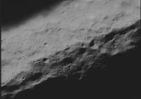
QUOTE (elakdawalla @ Sep 17 2009, 04:47 PM)  COOL. Thanks for the heads up. I love the "The full NAC mosaic reveals a shelf on the southeast flank of the crater that is more than two kilometers across and perfectly suitable for a future landing." --Emily
I think this is the area they are talking about (toward the bottom of the image). As Phil points out, directions are kind of useless near the Poles. But the upper part of the image is better illuminated due to the downward slope/Sun direction...so its the crater wall... not a good spot to land. So the more flat rim portion at the bottom of the image is a more likely spot to land, although it may not be near the best site to place the base (if we base it on having the shortest annual night period). I still need to get oriented on the image. Didn't find any rolling boulders yet!!! Drat!! |
|
|
|
|
|
|
Sep 17 2009, 07:27 PM
Post
#213
|
|
|
Solar System Cartographer Group: Members Posts: 10157 Joined: 5-April 05 From: Canada Member No.: 227 |
Earth must be generally towards the bottom of the image, from the location of the pole.
Phil -------------------- ... because the Solar System ain't gonna map itself.
Also to be found posting similar content on https://mastodon.social/@PhilStooke Maps for download (free PD: https://upload.wikimedia.org/wikipedia/comm...Cartography.pdf NOTE: everything created by me which I post on UMSF is considered to be in the public domain (NOT CC, public domain) |
|
|
|
|
Sep 17 2009, 11:26 PM
Post
#214
|
|
|
Member Group: Members Posts: 252 Joined: 5-May 05 From: Mississippi (USA) Member No.: 379 |
The Lunar Reconnaissance Orbiter Press Conference.
In case anybody missed it (like me) - an ASF video file can be downloaded at - 116 MB ASF file http://www.space-multimedia.nl.eu.org/ or http://bit.ly/Ahe4Y Also replay tomorrow on NASA TV 12:00 GMT September 18, Friday 8 a.m. Eastern Time - Replay Lunar Reconnaissance Orbiter Press Conference - GSFC (Public and Media Channels) Jack |
|
|
|
|
Sep 18 2009, 12:43 AM
Post
#215
|
|
|
Solar System Cartographer Group: Members Posts: 10157 Joined: 5-April 05 From: Canada Member No.: 227 |
Comparing the MiniRF mosaic and the LOLA topo map... the big massifs in the LOLA map, the red areas (they are South Pole-Aitken basin ring mountains) look unusually dark in the MiniRF. I don't see it as just topographic shading, but can't figure out what it is yet.
Phil -------------------- ... because the Solar System ain't gonna map itself.
Also to be found posting similar content on https://mastodon.social/@PhilStooke Maps for download (free PD: https://upload.wikimedia.org/wikipedia/comm...Cartography.pdf NOTE: everything created by me which I post on UMSF is considered to be in the public domain (NOT CC, public domain) |
|
|
|
|
Sep 18 2009, 10:42 PM
Post
#216
|
||
 The Poet Dude Group: Moderator Posts: 5551 Joined: 15-March 04 From: Kendal, Cumbria, UK Member No.: 60 |
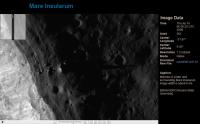
New image of Mare Insularum is up... now that's what I call a shadow!

-------------------- |
|
|
|
|
|
|
Sep 21 2009, 02:45 PM
Post
#217
|
|
|
Junior Member Group: Members Posts: 62 Joined: 30-July 09 Member No.: 4887 |
FULL INLINE QUOTE REMOVED - ADMIN
Anyone trying to download the entire 504 Mb file should note the name is incorrect. It is... http://lroc.sese.asu.edu/data/pr/tiff/nacl00001431.tif.tif |
|
|
|
|
Sep 21 2009, 11:16 PM
Post
#218
|
|
|
Newbie Group: Members Posts: 12 Joined: 24-August 09 Member No.: 4911 |
I'am still waiting on new images with a high resolution in low orbit
Last relaesed image 25-aug. Why must we wait so long for data? In 1969 we have live tv from the moon. Of is there a direct link too these images? |
|
|
|
|
Sep 21 2009, 11:48 PM
Post
#219
|
|
|
Solar System Cartographer Group: Members Posts: 10157 Joined: 5-April 05 From: Canada Member No.: 227 |
Patience! They have released plenty of images already. The new ones from half the height will not look very different for most targets. If you check the LRO website, the Operations Journal, you can read this:
"My name is Andrew, and I am currently an undergraduate Industrial, Systems and Operations Engineering student at Arizona State University, where LROC operations are based. At LROC, I am currently employed as the web developer. This means I am the person who is primarily responsible for maintaining, developing and making updates and additions to the LROC website (as well as other websites for associated projects)." Bearing in mind that they are getting a Niagara of data every day, and the website is updated by a busy student, I think they are doing a great job already. There's just too much downlink to have every image, every day the way MER does it. Phil -------------------- ... because the Solar System ain't gonna map itself.
Also to be found posting similar content on https://mastodon.social/@PhilStooke Maps for download (free PD: https://upload.wikimedia.org/wikipedia/comm...Cartography.pdf NOTE: everything created by me which I post on UMSF is considered to be in the public domain (NOT CC, public domain) |
|
|
|
|
Sep 22 2009, 02:07 AM
Post
#220
|
|
|
Senior Member Group: Members Posts: 1074 Joined: 21-September 07 From: Québec, Canada Member No.: 3908 |
A new image has been posted: a spectacular oblique limb view:
http://wms.lroc.asu.edu/lroc_browse/view/M106797147 |
|
|
|
|
Sep 28 2009, 06:01 PM
Post
#221
|
|
|
Junior Member Group: Members Posts: 62 Joined: 30-July 09 Member No.: 4887 |
"nother LRO image
http://wms.lroc.asu.edu/lroc_browse/view/M104419352R "The linear rille Rima Ariadaeus is found on the nearside of the Moon, nestled between Mare Tranquillitatis and Mare Vaporum." |
|
|
|
|
Sep 29 2009, 07:17 PM
Post
#222
|
|
|
The Poet Dude Group: Moderator Posts: 5551 Joined: 15-March 04 From: Kendal, Cumbria, UK Member No.: 60 |
-------------------- |
|
|
|
|
Sep 29 2009, 07:46 PM
Post
#223
|
|
|
Solar System Cartographer Group: Members Posts: 10157 Joined: 5-April 05 From: Canada Member No.: 227 |
Cool! And still in the commissioning orbit, so the final views will be twice as good.
Phil -------------------- ... because the Solar System ain't gonna map itself.
Also to be found posting similar content on https://mastodon.social/@PhilStooke Maps for download (free PD: https://upload.wikimedia.org/wikipedia/comm...Cartography.pdf NOTE: everything created by me which I post on UMSF is considered to be in the public domain (NOT CC, public domain) |
|
|
|
|
Sep 30 2009, 05:09 AM
Post
#224
|
|
 Member Group: Members Posts: 399 Joined: 28-August 07 From: San Francisco Member No.: 3511 |
So ... what's best for finding the actual site with Stu's Zoomify link?
-------------------- 'She drove until the wheels fell off...'
|
|
|
|
|
Sep 30 2009, 07:29 AM
Post
#225
|
|
|
Rover Driver Group: Members Posts: 1015 Joined: 4-March 04 Member No.: 47 |
This is something like 'Where's Waldo' to me

|
|
|
|
|

|
Lo-Fi Version | Time is now: 4th May 2024 - 11:01 AM |
|
RULES AND GUIDELINES Please read the Forum Rules and Guidelines before posting. IMAGE COPYRIGHT |
OPINIONS AND MODERATION Opinions expressed on UnmannedSpaceflight.com are those of the individual posters and do not necessarily reflect the opinions of UnmannedSpaceflight.com or The Planetary Society. The all-volunteer UnmannedSpaceflight.com moderation team is wholly independent of The Planetary Society. The Planetary Society has no influence over decisions made by the UnmannedSpaceflight.com moderators. |
SUPPORT THE FORUM Unmannedspaceflight.com is funded by the Planetary Society. Please consider supporting our work and many other projects by donating to the Society or becoming a member. |
|