Rev 164: Apr 5-23, 2012 - Enceladus E18, Tethys |

 Unmanned Spaceflight.com > Outer Solar System > Saturn > Cassini Huygens > Cassini's ongoing mission and raw images
  |
Rev 164: Apr 5-23, 2012 - Enceladus E18, Tethys |
 Apr 16 2012, 06:31 AM Apr 16 2012, 06:31 AM
Post
#1
|
|
 Member  Group: Members Posts: 655 Joined: 22-January 06 Member No.: 655 |
A little belatedly (to post here- the article's been up for a week or two), looking ahead for this revolution (now half complete) here
WAC enceladus from 185km - great detail! Some shots of tethys too - some are very smeared - spacecraft slewing during shuttering perhaps?? Also some enceladan plumes Great stuff! |
 |
 
|
|
Apr 16 2012, 07:24 AM
Post
#2
|
||
|
Member Group: Members Posts: 655 Joined: 22-January 06 Member No.: 655 |
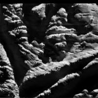
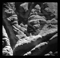
Worth posting that Enceladus image here. Image rotated and enhanced a little (wow!):
Attached thumbnail(s)
|
|
|
|
|
|
|
Apr 16 2012, 11:39 AM
Post
#3
|
||
|
Solar System Cartographer Group: Members Posts: 10145 Joined: 5-April 05 From: Canada Member No.: 227 |
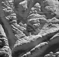
Great picture! Here I have brought out more detail in the shadows.
Phil
-------------------- ... because the Solar System ain't gonna map itself.
Also to be found posting similar content on https://mastodon.social/@PhilStooke NOTE: everything created by me which I post on UMSF is considered to be in the public domain (NOT CC, public domain) |
|
|
|
|
|
|
Apr 16 2012, 11:53 AM
Post
#4
|
|
 IMG to PNG GOD Group: Moderator Posts: 2250 Joined: 19-February 04 From: Near fire and ice Member No.: 38 |
QUOTE (jasedm @ Apr 16 2012, 06:31 AM)  Some shots of tethys too - some are very smeared - spacecraft slewing during shuttering perhaps?? Apparently all of the smeared images are UV2 images. UV2 requires a far longer exposure time than most filters. Still seems like a lot of smear though. |
|
|
|
|
Apr 16 2012, 01:34 PM
Post
#5
|
|
|
Solar System Cartographer Group: Members Posts: 10145 Joined: 5-April 05 From: Canada Member No.: 227 |
The WAC image taken from the same distance is a narrow crescent - so these images must be of the Saturn-lit side, hence the long exposure.
Phil -------------------- ... because the Solar System ain't gonna map itself.
Also to be found posting similar content on https://mastodon.social/@PhilStooke NOTE: everything created by me which I post on UMSF is considered to be in the public domain (NOT CC, public domain) |
|
|
|
|
Apr 16 2012, 01:46 PM
Post
#6
|
|||
|
Member Group: Members Posts: 655 Joined: 22-January 06 Member No.: 655 |
Thanks Bjorn - that would make sense re: the smearing.
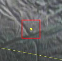
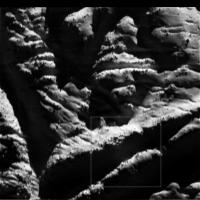
Just in case anybody is not already blown away by the accuracy of the spacecraft sequences on this mission, below is that WAC shot compared to Jason Perry's 'looking ahead' simulated view (the red square). Accurate to within a few tens of metres! All from a spacecraft 1.3 billion kilometres away, travelling past the target at 7.5km/second. Sweet. Incidentally the yellow square is the boresight for the narrow angle camera, and although a shot was taken (N00185750), unfortunately it fell completely in the shadows in the middle of the larger shot, and is almost completely black. I'm not sure it would have been too useful anyway though...
Attached thumbnail(s)
|
||
|
|
|
||
|
Apr 16 2012, 04:13 PM
Post
#7
|
|
|
Solar System Cartographer Group: Members Posts: 10145 Joined: 5-April 05 From: Canada Member No.: 227 |
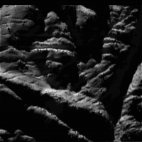
... except that the shadows are not black, as my image above shows, so if it's not too smeared there should be plenty of detail in it.
Phil -------------------- ... because the Solar System ain't gonna map itself.
Also to be found posting similar content on https://mastodon.social/@PhilStooke NOTE: everything created by me which I post on UMSF is considered to be in the public domain (NOT CC, public domain) |
|
|
|
|
Apr 16 2012, 04:59 PM
Post
#8
|
|
 Senior Member Group: Moderator Posts: 3230 Joined: 11-February 04 From: Tucson, AZ Member No.: 23 |
The nac isn't completely black. You can make out stuff in the shadowed regions, and there are a few streaks from points that reach into the sunlight. Unfortunately, it is quite smeared and the low exposure time (5 ms) isn't the best for making out details in the shadows.
-------------------- &@^^!% Jim! I'm a geologist, not a physicist!
The Gish Bar Times - A Blog all about Jupiter's Moon Io |
|
|
|
|
Apr 16 2012, 05:41 PM
Post
#9
|
||
 The Poet Dude Group: Moderator Posts: 5551 Joined: 15-March 04 From: Kendal, Cumbria, UK Member No.: 60 |
After a bit of a play about...
-------------------- |
|
|
|
|
|
|
Apr 16 2012, 06:22 PM
Post
#10
|
||
|
Member Group: Members Posts: 655 Joined: 22-January 06 Member No.: 655 |
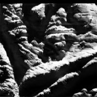
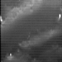
QUOTE (Phil Stooke @ Apr 16 2012, 05:13 PM) ... except that the shadows are not black, as my image above shows, so if it's not too smeared there should be plenty of detail in it. Phil Fair enough Phil, hope some detail can be teased out. Incidentally, I expect to be widely lambasted here  , but could this be a hint of vented gases (see box below). Illumination is from the 'top' so one would expect that side of the canyon to be uniformly dark. , but could this be a hint of vented gases (see box below). Illumination is from the 'top' so one would expect that side of the canyon to be uniformly dark.
Attached thumbnail(s)
|
|
|
|
|
|
|
Apr 16 2012, 06:51 PM
Post
#11
|
|||
 Member Group: Members Posts: 796 Joined: 27-February 08 From: Heart of Europe Member No.: 4057 |
This is simple gif, which gives basic clue, what can be seen in raw file N00185750 and its "raw" jpg image reduced to 1/5 size.
I think that calibrated raw version will be useful, because it'll bring some more informations about terrain in this place, than WAC image (despite smearing).
Attached thumbnail(s)
-------------------- |
||
|
|
|
||
|
Apr 16 2012, 07:20 PM
Post
#12
|
|
|
Solar System Cartographer Group: Members Posts: 10145 Joined: 5-April 05 From: Canada Member No.: 227 |
Nice! Yes, more detail from the raw data, of course, when we get it.
Phil -------------------- ... because the Solar System ain't gonna map itself.
Also to be found posting similar content on https://mastodon.social/@PhilStooke NOTE: everything created by me which I post on UMSF is considered to be in the public domain (NOT CC, public domain) |
|
|
|
|
Apr 16 2012, 08:37 PM
Post
#13
|
||
 Senior Member Group: Members Posts: 1417 Joined: 26-July 08 Member No.: 4270 |
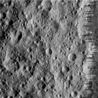
Wow, what's the resolution of that NAC image?
Anyone notice the multiple linear, parallel grooves on Tethys? Has this been thought about in the context of this body?
Attached thumbnail(s)
-------------------- -- Hungry4info (Sirius_Alpha)
|
|
|
|
|
|
|
Apr 16 2012, 08:53 PM
Post
#14
|
|
|
Member Group: Members Posts: 796 Joined: 27-February 08 From: Heart of Europe Member No.: 4057 |
If distance to the terrain in those images is really 185 km, then ~11 m/pix for WAC image and ~1.1 m/pix for NAC image. So theoretically smallest visible details could be only 2.2 meters wide, but realistically, after some processing and for raw file, my guess is, that details (with high contrast) with size about 6 to 12 meters could be recognizable (some boulders, I presume).
Which is not bad result, maybe it's even record for Enceladus. If my memory is right, then best image to date had resolution ~4 m/pix (and this image was smeared too, but not so badly), so details around 8 to 10 meters were recognizable. -------------------- |
|
|
|
|
Apr 16 2012, 09:04 PM
Post
#15
|
|
|
Solar System Cartographer Group: Members Posts: 10145 Joined: 5-April 05 From: Canada Member No.: 227 |
Hey, Hungry - wow, first time I've noticed those grooves. I wonder how far they extend.
Phil -------------------- ... because the Solar System ain't gonna map itself.
Also to be found posting similar content on https://mastodon.social/@PhilStooke NOTE: everything created by me which I post on UMSF is considered to be in the public domain (NOT CC, public domain) |
|
|
|
|

|
Lo-Fi Version | Time is now: 18th April 2024 - 05:37 AM |
|
RULES AND GUIDELINES Please read the Forum Rules and Guidelines before posting. IMAGE COPYRIGHT |
OPINIONS AND MODERATION Opinions expressed on UnmannedSpaceflight.com are those of the individual posters and do not necessarily reflect the opinions of UnmannedSpaceflight.com or The Planetary Society. The all-volunteer UnmannedSpaceflight.com moderation team is wholly independent of The Planetary Society. The Planetary Society has no influence over decisions made by the UnmannedSpaceflight.com moderators. |
SUPPORT THE FORUM Unmannedspaceflight.com is funded by the Planetary Society. Please consider supporting our work and many other projects by donating to the Society or becoming a member. |
|