Printable Version of Topic
Click here to view this topic in its original format
Unmanned Spaceflight.com _ Opportunity _ Victoria's Stratigraphy
Posted by: Bill Harris Oct 2 2006, 01:56 AM
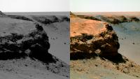
Here are a series of false-color L257 Pancams of the current Oppy traverse stop. I'm still in the "arch the eyebrows and muttering 'fascinating' " mode so I don't have any words of wisdom right away. We can discuss over the next few day/sols before she moves on to the next miracle...
Cabo Frio: (order is #3, #1, #2 from left):
Posted by: Bill Harris Oct 2 2006, 02:00 AM
Image #4 at Cabo Frio:
Posted by: Bill Harris Oct 2 2006, 02:07 AM
Cabo Verde (order is #1, #2, #4, #3, from left):
Posted by: nprev Oct 2 2006, 02:12 AM
Good grief, and mega<clinks> for the swear jar...thank you, Ed.
My first impression of Cabo Frio is that there seems to be a preferential side of the formation for wind erosion, and it looks like it's the opposite side from where Cabo Verde (did I spell it right, ustrax? Please don't hit me again! 
 ) exhibited the same effect, and THAT seems really strange...almost as if there's an "air channel" in and out of the crater. Does the low atmospheric pressure & diurnal variation make that kind of a difference?
Posted by: Myran Oct 2 2006, 03:41 AM
Wind erosion - of course we see wind erosion!
Once I did visit Australia, and the tourguide took us to a site and claimed the rocks and cliffs were as they were from the age of the dinosaurs.
Coming from a location where everything have changed since the last iceage just 10 000 years ago, that idea gave me vertigo.
Yet those cliffs and bedrock in Australia are something to compare with what we have here, then multiply the age times 10, 20 or perhaps even 50 times. Over such timescales we only can be happy that erosion might have been slow on Mars.
Posted by: CosmicRocker Oct 2 2006, 05:24 AM
Bill, I can see you are finding interesting things to do in your retirement.
I have to go to bed...I must perform paid labor, tomorrow... ...Still dreaming...
...enjoy.
Posted by: Bill Harris Oct 2 2006, 10:41 AM
Not only the geology of this locale, but also, and as importantly, the geomorphology, "how did it get to look like it is today?" is open for study here. Getting the ground-truth here will help us in interpreting MRO imagery. Although, by Earth-standards Mars has a thin, almost non-existent atmosphere, we can see that it is currently _the_ major player in erosion, transport and deposition.
One thought: Mars has a weak magnetic field and a thin atmosphere, so the cosmic ray flux is orders of magnitude higher than on Earth. And the erosional process is much slower so a given rock will lay on trhe surface for thousands or millions of years. What is the effect of millions of billions of cosmic ray impacts on the component mineral crystals of a rock? The crystal lattice must be perforated like a zeolite...
On the "R-word". I do look at it as "graduation" and having paid my dues on my day job, with a 27-year investment paying off. I've got a lot to do the next few years. I'll continue in the OT section later today...
--Bill
Posted by: diane Oct 2 2006, 10:59 AM
I do find the stratigraphy of Cabo Frio to be mystifying. There are the long diagonal layers on the side, but out at the tip there are horizontal layers. How the <clink, clink> could that happen?
Posted by: prometheus Oct 2 2006, 12:39 PM
Cabo Frio in 3D
|
Posted by: Gray Oct 2 2006, 01:49 PM

Diane
I'm not sure which view you're looking at, but in general, if a series of parallel planes are inclined (as in some cross-bedding), one cross-section will show the dipping layers, but if you rotate the block ninety degrees, a cross section will show horizontal strata. One of the images about 3/4 down on this page http://www.geologie.uni-stuttgart.de/online_kurse/Online_100/Sedimenttrans+strukturen/Seite7_1.htm shows what I'm trying to describe.
Lee
Posted by: ngunn Oct 2 2006, 02:22 PM
I'm annoyed I can't find it but somebody posted the picture in one of the threads with both the horizontal and diagonal lines highlighted and offering the following suggested interpretation: horizontal are stratigraphic beds, diagonal are fracture planes produced by the shock of impact. Seemed reasonable to me.
Posted by: sranderson Oct 2 2006, 03:25 PM
I am somewhat concerned that what we see as stratigraphic bedding or even fracture planes might be caused by wind erosion that occurs within only a few centimeters of the regolith surface. Then as the surface recedes, more rock is exposed and a new layer of erosion occurs. This seems consistent with some of the angles of the outcrop strata with respect to the angle of the ground surface of Duck Bay.
That "marker bed" on Cabo Verde might not be true layers, but rather evidence for successive cycles of wind erosion. Each layer is a climate change causing a wind change, causing different erosion.
When you see blocks planed flush to the surface of the ground, wind erosion takes on a rather dreadful importance. We sometimes don't understand it because of our earth geology biases.
Scott
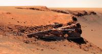
Posted by: tdemko Oct 2 2006, 04:06 PM
Here is my quick-n-dirty interpretation of the stratal geometry of Cabo Verde on a photo posted yesterday by Nix.
A couple of notes:
1) the lighter-colored upper bedrock unit is in stratal continuity with the lower striped unit...it looks like the upper, steeper beds are foreset laminae and the lower horizontal to gently inclined beds are toesets deposited by the migration of a dune (this is what I call festoon crossbedding!)
2) my interpretation would be that these are the deposits of a prograding eolian dune with well-developed avalanche-face foresets, and that the toesets are built out of grain-flow tongues separated by grain-fall drapes and wind-ripple translatent strata
3) the ejecta is bloody thick here and most, if not all, of the overlying evaporite beds have been blasted away..only a highly-fragmented zone of evaporite-rich ejecta blocks remain...this is likely to be variable around the crater and I'm sure we will see some in-place evaporite beds on top of the eolian beds...maybe even in the next bay
|
Posted by: dvandorn Oct 2 2006, 04:56 PM
That all makes sense to me. What doesn't make sense is how the evaporite-rich ejecta strata seems to be *more* erosion-resistant than the aeolian deposits. We seem to see this phenomenon all around the crater, a lighter-toned bed of apparently evaporite-rich rock that appears to form a resistant bed, which has stayed in place even while the aeolian deposits below them are undercut.
The evaporite we've seen here, both unshocked (out on the plains) and shocked (within Endurance), seems to be the softest rock around. It's certainly a lot softer than the volcanic rocks over at Gusev. It almost appears, at times, so friable that it would simply crumble if held in the hand and squeezed.
Any idea how such soft rock becomes the most erosion-resistant rock in the walls of such a big crater?
-the other Doug
Posted by: Nix Oct 2 2006, 05:08 PM
Any idea how such soft rock becomes the most erosion-resistant rock in the walls of such a big crater?
-the other Doug
Could it have anything to do with the depth of the crater? ..wind tunneling down inside and around in the bowl of the crater, leaving the top layers relatively intact? just a guess...
Nico
Posted by: Gray Oct 2 2006, 05:41 PM
dvandorn
In this case I think what might be happening is that the aeolian layer *is* the more resistant layer which is responsible for the steep cliffs. The evaporite-rich ejecta layer is protected from the undercutting simply because it's sitting on top of the more resistant bed. The more surficial processes have beveled it back somewhat - which makes the aeolian unit that much more prominent.
That's my take anyway.
Posted by: sranderson Oct 2 2006, 07:14 PM
Here is what I think:
When you get much more than a couple of centimeters about the local surface, the erosion rate decreases dramatically. Almost all erosion occurs within a few centimeters of the surface. Local topography can modify this somewhat. Tops of cliff faces don't get much erosion at all. The evaporite-rich layer is protected from the undercutting because it is several meters above the surface -- and therefore has been subjected to very little wind erosion.
A way to envision it is to imagine that the layer of air right above horizontal surfaces is corrosive.
Scott
Posted by: WindyT Oct 2 2006, 07:14 PM
my guess: groundwater rising, movement of cementation materials, ground water leaving, slumping some areas.
One layer might be more prone to fail after the water level dropped.
Posted by: algorimancer Oct 2 2006, 08:41 PM
Not necessarily relevant, but do caves form in evaporite (salt, on earth) in the same way that they do in limestone? In other words, is there an evaporite version of karst terrain to look for on Mars?
Posted by: helvick Oct 2 2006, 08:54 PM
I don't know if they form Karsts but a quick google search of http://www.radio.cz/en/article/74898 or "http://giantcrystals.strahlen.org/europe/merkers.htmor http://giantcrystals.strahlen.org/america/naica.htm turns up loads of hits.
Posted by: CosmicRocker Oct 3 2006, 06:07 AM
I am so blown away by the long baseline anaglyphs of the opposite rim that I am having a difficult time thinking of anything else.
Another thing that continues to confuse me is the way the term "evaporite" is so frequently used here. I thought that all of the rocks we have seen are really sandstones that have been later cemented by evaporites. What is the "evaporite" layer many keep talking about? Is it the upper part of the Burns formation seen at Endurance?
O'Doug: These are probably quite soft rocks, but I would think not quite as friable as you suggest. Regardless of that, the important thing to consider in erosive environments is the relative durability of the layers. These cliffs exist, regardless of how incompetent they may be.
Posted by: dvandorn Oct 3 2006, 07:29 AM
Actually, I believe I was the first one here on UMSF to refer to the light-toned, layered bedrock first seen in Eagle and later seen, well, everywhere at Meridiani as evaporite. It was about a week after I first used the term that I can first remember Squyres using it during a press conference or in one of his updates. I started using it because of the Anatolia-like crack features I could make out in the enhanced DIMES images, which suggested strongly to me the polygonality of dried sea floor beds. It just made sense to me that the surface we were seeing was the result of the dessication and shrinkage of a wet sand or mud unit; when the first-look at the rocks revealed them to be composed largely of sulfur salts, I laid the label of evaporite on them.
Technically, I suppose only the sulfur-salt matrix of the light-toned rocks are actually formed from evaporation of acidic, high-sulfur groundwater, and the resulting rocks are more accurately described as sandstones with evaporitic cementation. But since the high-sulfur-salt-content rocks were formed by multiple epochs of evaporation (and possibly sublimation?) of sulfurous, acidic water, it's just been a good shorthand to refer to them as evaporite rocks. And it differentiates them from the more pure sandstones that seem to underly the evaporite layers (the lower portions of the Burns formation).
I just keep wondering -- if there's a Burns formation, oughtn't there be a Smithers formation?
-the other Doug
Posted by: dvandorn Oct 3 2006, 07:48 AM
I just checked my old posts, and the term I used first on May 7, 2004 was "evaporation layers" to describe the light-toned rock beds evident throughout the Meridiani area. In a post I made ten minutes after that, I referred to individual rocks within the unit as evaporite.
Funny -- I made two posts on the old forum on 2/9/04, and then didn't post again until 5/7/04. Well, my marriage was falling apart at the time, I suppose I was allowed a little distraction... *sigh*...
-the other Doug
Posted by: ustrax Oct 3 2006, 10:52 AM
OMG!

Where have I seen all this before?!...

Posted by: Bill Harris Oct 3 2006, 11:07 AM
Now that we have "drill holes and cores" to look at here, it appears that this will prove to be a very complex area to understand.
Tim Demko has it nailed: the cross-bedded evaporite unit overlain by ejecta rubble. The underlying bedrock has it's own complex history of aeolian activity, playas, groundwater interaction and earlier impacts. And then there was the more recent impact of Victoria which disrupted, fractured and shocked the bedrock; we may be looking at upturned beds here. And then there is the subsequent weathering and erosion of the freshly-exposed evaporite surfaces. Subsequent processes include undercutting, slumping and collapse of the cape blocks. And so on...
"Evaporite". That is a frequently-used misused term. I use that as a catch-all term to refer to the primary class of rock here: the sulfate-rich indurated silicic sedimentary unit that has a light-toned IR appearance and has the salmon-ochre hue in false color. We started using that term when we discovered the magnesium sulfate rich layered rocks exposed in Eagle crater. There may be a proper petrographic term for this rock, but the term of "evaporite" is well-understood here.
Smithers Formation? Ugh.
--Bill
Posted by: aldo12xu Oct 3 2006, 04:44 PM
Belated congratulations on your retirement, Bill!! You couldn't have picked a better time 
Amazing how many new posts there have been in the past 3-4 days. I hardly know where to start. Amazing images, nice colour renderings and enhancements.
Tim Demko's aeolian unit seems to correspond the unit making up Cabo Frio. I wonder if this is also stratigraphically correlated to the cross-stratified Burns Cliff sandstones (Burns Formation Lower Unit). If that's the case we've only gone down 4 metres in the stratigraphic column over a distance of 5 km:
http://www.unmannedspaceflight.com/index.php?act=Attach&type=post&id=6987
Or, since the elevation has been increasing as Opportunity traveled south, could the Cape Verde rocks be overlying the well laminated Upper Unit we saw at the top of Eagle and Endurance Craters? Phil Stooke's enhanced version of Cape Verde shows the unit underlying Tim's aeolian unit to be very finely laminated:
http://www.unmannedspaceflight.com/index.php?act=Attach&type=post&id=7817
Also, could the Cape Verde horizon be the source for the dark cobbles seen between Erebus and Victoria?
Posted by: tty Oct 3 2006, 05:57 PM
Yes they do, though it is very rare on Earth because the climate is very rarely dry enough. The main example is Mount Sedom southwest of the Dead Sea in Israel. Monut Sedom is basically a salt dome that has risen to form a modest mountain, since there is not enough rain to melt it (as happens almost everywhere else). There is however enough to form a fairly complex cave system, "halokarst".
tty
Posted by: CosmicRocker Oct 4 2006, 05:21 AM
I understand that we have all conveniently used the term "evaporite" to describe the light toned bedrock everywhere since early in this mission. My question about the recent use of the term was based on some comments where I thought some were suggesting that there were evaporites overlying sandstones. I only wanted to clarify that. I was afraid that I might have missed an important contact. I can't lay my hands on one at the moment, but the last vertical profile of sulfate and halite content I remember seeng from the Endurance section showed a small decrease in those salts at the bottom, but not a lot.
I don't know about the rest of you, but I am suffering from a serious information overload since we arrived here. Let's all keep our attention up at this Friday's briefing. I wish they had more than the few speakers who are scheduled, though if I had to pick two, my choices will be speaking. It's been a long time since the last briefing, but they always were pretty enlightening in the past...
Posted by: Bill Harris Oct 4 2006, 09:28 AM
Complex, yet unknown, Tom. Let me post again the Grotzinger, et al strat section.
A good review of the known strat is at Aldo's MarsGeo site, http://www.marsgeo.com/Opportunity/BurnsCliff.htm and http://www.marsgeo.com/Opportunity/RockTypes.htm.
I am starting, on my local disk, a directory of images of the strat section arranged by capes/bays so I can keep up with the info as it comes in. Wonder if we can/should start something like that on UMSF?
--Bill
Posted by: Aberdeenastro Oct 4 2006, 09:55 AM
Bill,
I'm assuming that the Upper Unit in that sequence is what we've been calling evaporite. I must admit I've not really been happy with the term evaporite in this setting. I've worked the Permian of the UK Southern North Sea, where similar formations exist. The term interdune/playa is more appropriate, with evaporites referring to the salts that crystalise in amongst the interdune sediments. To me a true evaporite is something like a thick halite or anhydrite section, such as you get in seas/lakes on Earth in hot climates with little sediment input. In those cases the evaporite forms by evaporation of the water under high temperatures. Here on Mars, the process is more likely to be due to loss of atmospheric pressure causing evaporation. It will be interesting to see if we can correlate the Burns Cliff section with Victoria, although any interpretations are likely to be speculative without having continuous exposure of rocks in between.
Aberdeenastro
(previously known as Castor)
Posted by: Nix Oct 4 2006, 10:09 AM
I am starting, on my local disk, a directory of images of the strat section arranged by capes/bays so I can keep up with the info as it comes in. Wonder if we can/should start something like that on UMSF?
--Bill
It may not be a bad idea to pin a few separate threads for individual capes/bays as you propose Bill.
This place is big after all and Oppy will spend at least a year here.
Nico
Posted by: tdemko Oct 4 2006, 03:20 PM
Thanks, Bill, for reposting the stratigraphic column by Grotzinger et al. constructed from the efforts at Eagle and Endurance craters. It is a good place for us to start our discussions of the Victoria exposures.
This is also a good place to do a little nomenclatural housekeeping. I tend to be very exacting with my students on these topics, but get a little sloppy myself, especially in an informal situation like internet discussions or email.
When communicating ideas about rocks or sediments, especially layered rocks or sediments, it is always good practice to keep observations and interpretations separate, especially in how we name and classify them. This is expressed in the concept of lithofacies in which we classify and name a sediment or rock based upon the fundamental properties of composition, texture, sedimentary structures, form, association, and fossils (if present). An example of a lithofacies would be a "medium-grained, cross-bedded sandstone". On the other hand, the depositional environment of a package of ancient sediments or sedimentary rocks is an interpretation based on analyses of these fundamental properties and the changes between, and association with, units above, below, and laterally adjacent. We sometimes mix these two concepts into a hybrid "depositional facies" like an "eolian sandstone". The word "evaporite" also fits this situation. The lithofacies is probably something like a "thinly-laminated to ripple cross-laminated, tightly cemented, recrystallized, magnesium sulfate sandstone". I'm not about to type that every time, so I lazily fall back on evaporite.
There is one more way to classify and name layered rocks, and that is formal stratigraphic nomenclature. These would be the formal names of supergroups, groups, formations, and members. There are two publications that deal with the details of naming these units that codify how it is done, the http://www.agiweb.org/nacsn/code2.html and the http://www.stratigraphy.org/guide.htm. Inherent in both are the concepts that depositional environment AND age should have no bearing on the delineation and naming of formal stratigraphic terms. The preferred root of the name is typically a geographic location where the unit was first described, or where it is exceptionally exposed.
So back to the figure from Grotzinger et al....they term the units as parts of the "Burns formation". By the fact that they do not capitalize the word "formation", I am guessing that they are not trying to erect a formal stratigraphic nomenclature here. In fact, I'm not sure if the Code or the Guide have any extrerrestrial impact at all (although I do not see why this should matter). However, they do erect several subformational units, the Lower, Middle, and Upper units, which they (confusingly) do capitalize, implying that they are "formal" stratigraphic units. The other parts of the diagram, especially the sections labled "Primary Facies" and the text to the right of the column have the evil mix of observation and interpretation that I was discussing above. The "Primary Facies" are grouped by their interpretation of paleohydrology (Dry, Dry to Damp, and Damp to Wet), but followed by both terms of environmental interpretation and physical sedimentologic description (i.e. eolian sandsheet interdune and ripple cross-stratified). The text to the right of the column groups the units by depositional environment and diagenetic features, and the smaller font supporting text has physical sedimentological lithofacies descriptions, environmental interpretations, and even speculative interpretations. It's a bit of a mess...if this manuscript was sent to me to review (hint, hint to any editors or PI's reading...), I would have recommended that the observations/data be convincingly separate from the interpretations in this diagram (and in the main text, by the way...).
Now, this is not to take anything away from this paper...it's a great summary of some landmark research that has implications far beyond Endurance crater, and in fact, along with other information coming out of the MER program, it has changed some of our basic ideas regarding the history of surfical conditions on Mars.
However, it does show that even the Big Guns/Chosen Ones get a little sloppy sometimes, too...and mea culpa, I will try to strive to set a better example, even in the informal setting of UMSF!
Posted by: Bill Harris Oct 4 2006, 06:35 PM
Very good duscussion and guidance, Tim. I confess that I may be the world's worst at naming rocks, I'm 30-odd years out of school and have spent the last quarter-century knocking around the Pottsville Formation (essentially flat-lying beds of sandstone and shale with enough coal to make it economically viable) AND reviewing geologic descriptions written by engineers.  I've picked up horrid habits. We do need to work on our descriptions, but we have only so much to work with online. I'll dust off my textbooks.
Grotzinger, et al is the landmark-but-initial paper on the first leg of the traverse at Meridiani. As more data comes in and as subsequent papers come out we'll know mnoe wbut thisis the standard reference so far. The "Burns formation" is more honorary and is shorter to say that "them strata we first saw at Endurance" for the time being. I wish we had been able to get a close look at the bluffs at Payson to get a midpoint between Endurance and Victoria. The jury is still out for me with the so-called Halfpipe formation. I've not quite figured out what it is.
Victoria is exciting. I look at each Cape as a drill hole or "highwall exposure", Twenty-four of 'em arranged in a 700 meter circle. There is an apparent stratigraphic marker near the top and I think I can see continuity as well as change between exposures.
--Bill
Posted by: CosmicRocker Oct 5 2006, 05:28 AM
Thanks everyone, for the more-than-adequate explanation of the use of the term "evaporite." I guess I understood what it has historically meant here. In some discussion in this forum I thought I remembered it being distinguished from the sandstones. I guess we can carry on. I am comfortable with simply calling this light-toned pile of sediment "evaporite."
I would like to introduce some of the concepts from the Edgett paper (in volume 1, here: http://marsjournal.org/contents/ ). Keep in mind that this stuff is taken somewhat out of context. The original paper covers many concepts. I have been waiting a long time to see Victoria, and to see if his crater exhumation ideas will be upheld. So far, I think they are.
Here are two captioned images from the larger paper. I think they provide a good overview of his crater exhumation ideas. If we can find evidence here that this process is occurring at Victoria, we will need to distinguish between pre-impact stratigraphy and post-impact stratigraphy...and even more recent stratigraphy.

|

|
In order to keep this in context as well as I can without copying the entire paper, here is the description of figures 21 and 22 from the main text:
"MOC images of craters near the MER-B site suggest that the plains-forming unit exhibits a progression of crater expressions, from those that are buried to those that are partially to fully exhumed (Figure 21). Endurance Crater, explored by MER-B, might have once been partially filled like the crater in Figure 21a. Victoria Crater (Figure 21b) illustrates the next stage in the exhumation of a crater in the plains-forming unit. The U-shaped alcoves eroded into rock around the craters circumference indicate erosion by undermining and collapse as less-resistant crater-filling material and/or brecciated crater wall material was broken down and removed from the crater, perhaps by wind. The rock into which the U-shaped alcoves formed overlies the original (presently buried) Victoria Crater rim. Endurance Crater (Figure 21c, d) might be showing the next stage in the process. At Endurance, the raised crater rim is topographically expressed, as are some aspects of ejecta blanket, but none of the original rim nor ejecta are fully exhumed. For comparison, Figure 21e shows a fresh craterone never buriedon Meridiani Planum."
At marsjournal.org you can download the whole paper, and all of the images in their png splendor.
Posted by: CosmicRocker Oct 5 2006, 05:41 AM
I didn't quite have enough space left to include this last image. I didn't appreciate this burial and exhumation process when we were at Endurance, so I think I missed a lot of important observations when we were there. I did remember a few things though, and went back to find this image.
There were very few observations of something like this. On sol 118 Opportunity captured this image of what I am interpreting as possibly some draping layers of the initial crater fill. Granted, this might also be explained by some kind of secondary weathering or diagenetic process, but I could never forget this picture.

|
Posted by: Bill Harris Oct 5 2006, 08:01 AM
Thanks, Tom. Very relevant post for understanding what is happening here at Victoria and at Meridiani. I had been meaning to grab that Edgett paper thru our big pipeline at work but never got around to it, so I'll wait for a good dialup time and download it soon.
Burial and exhumation explains a lot on what we are seeing at Victoria. It looks so fresh and new, but only because we are seeing newly exposed and active surfaces in the bluffs. Not only do we have the pre-impact Meridiani units to contend with we also have the intermediate fill or burial units present. This explains the character of the ejecta blanket: we haven't been seeing the ejecta blanket per se but the expression of the ejecta blanket as it has filled in the rough surface of the etched terrain. This explains why we the the everpresent basaltic sand and blueberries where I/we had hoped to see pulverized "victoria guts".
I've had a hard time getting my hands around the exhumation process. Not that I doubt that it exists, I just can't clearly visualize how the infilling sand, silt and (presumably) "re-indurated evaporite material" is removed from the crater by the wind. Some things you take on faith without completely understanding (for the time being).
--Bill
Posted by: ngunn Oct 5 2006, 04:34 PM
--Bill
This is a very interesting line of speculation and I can see why it appears to fit with the surface materials and appearance of the apron, but I have the same difficulty in coming to terms with exhumation by wind. Why should a crater steadily fill up with dust and sand after its formation and then systematically empty itself of the same materials? I think we'll have to wait for more pieces of the jigsaw before the real story emerges. Fortunately there's quite a few lying around.
Posted by: aldo12xu Oct 5 2006, 04:45 PM
Yes, thanks Tom for reminding us of Edgett's paper. Like Bill, I never had chance to read the paper in detail. The exhumation process certainly seems to explain the appearance of crater rim wallrocks at Endurance and Victoria. But I'm having trouble picturing the step by step process:
1. Pre-existing Meridiani "evaporitic sandstones"
2. Meteorite impact
3. Impact crater gets buried by windblown sand
4. Water table rises, soaking sands, water evaporates, diagenesis, etc., creating 2nd sequence of "evaporitic sandstones"
5. More aeolian deposition, water table interaction, etc., creating additional evaporitic sequences
6. Erosion sets in and removes evaporitic sequences, layer by layer
7. As erosion works its way down to the old crater rim.......???
.....this is where I have the problem: If the rate of erosion over the crater is constant, why is that we don't see one contiuous erosional surface stretching from one side of the crater rim to the other. For example, the cross-stratified sandstone at Cape Verde seems to be an extension of the same unit seen at Cabo Frio, and, more than likely, continues along the other alcoves. I understand how undercutting could've occurred due to the lower unit being less resistant to erosion once the rim of the crater became exposed, but how is it that material seems to have been preferentially removed from the interior "bowl" of the crater first?
Posted by: ElkGroveDan Oct 5 2006, 04:55 PM
Well not to belabor the point, I would distinguish between an evaporite and a sandstone/siltstone in the following way. An evaporite is created from an accumulation of chemical precipitates that had been dissolved in solution. The desert playas of the American Southwest are covered with the stuff. The floor of Death Valley is exceptionally thick. Sandstone on the other hand is created by solid granules, eroded from the mother rock and carried in suspenison, typically water or air, or sometimes simple downslope mass wasting. Those particles then drop out of suspension and go through a cementation process, either a chemical precipitate or they become cemented through heat and pressure.
Posted by: kenny Oct 5 2006, 04:58 PM
The fact that exhumation of layers is steadily taking place around the inner rim of Victoria does not conflict with the intuitive expectation that the crater is slowly filling up with (a) liberated erosional products tumbling down from the eroding faces, ( wind blown fines from further afield on Mars, and © occasional ejecta from other impacts. Most of what gets into Victoria never gets out. This would be due to the low "lift" capability of the local winds (speed and atmospheric density), their likely reduced strength inside the bowl vis a vis outside on the open Meridiani Plains, and the simple geometry of a crater - scouring out requires upwardly-corkscrewing winds fast enought to lift solid material. A tall order for anything other than very fine dust, I suggest.
Victoria as a crater is doomed, its bottom already a deep pile of tumbled-in material overlaid by the net of wind-blown dust ripples we see on top. It is slowly on its way to becoming an Erebus.
Kenny
Posted by: Shaka Oct 5 2006, 07:04 PM
2. Meteorite impact
3. Impact crater gets buried by windblown sand
4. Water table rises, soaking sands, water evaporates, diagenesis, etc., creating 2nd sequence of "evaporitic sandstones"
5. More aeolian deposition, water table interaction, etc., creating additional evaporitic sequences
6. Erosion sets in and removes evaporitic sequences, layer by layer
7. As erosion works its way down to the old crater rim.......???
.....this is where I have the problem:
I agree there's a bit of a problem, Aldo, but how about if we rewrite the steps accepting that the VC impact occurred during Mars 'wet period', to whit:
1. Pre-existing Meridiani sandstones - saturated (+ or -) with water/ice
2. VC impact forms crater.
3. Hot crater fills with inflowing water and/or windblown sand and/or ice crystals and/or snow.
4. Water-rich fill freezes and is covered by layers of windblown sand.
5. Water covers/saturates surface layers, indurating sands with sulfates.
6. Later acid-wet episodes leach and deposit hematite concretions in surface layers.
7. Mars enters dry period (> present).
8. Eolian erosion deflates surface layers leaving lag 'blueberries'.
9. Water in crater fill escapes through warming or sublimation, leaving spaces in fill.
10. Surface 'evaporite' layers collapse into crater cavity exposing broken edges to rapid erosion.
11. Victoria cavity "exhumed" by continuing collapse and erosion from strong winds.
12. Original VC rim remains buried, or eroded away between steps 3 and 6.
???

Posted by: lars_J Oct 5 2006, 11:14 PM
|
|
I find the caption on this image to be completely counter-intuitive. But keep in mind that I am a complete layperson when it comes to geology

The caption imples that crater C (Endurance) once looked like A and B.
But to my eye it looks rather obvious that the progression shoud be from C to B to A, as the crater erodes and is filled in by sand. But I could of course be completely wrong.
Posted by: Shaka Oct 6 2006, 12:00 AM
Your confusion is entirely understandable, but you aren't following the researcher's explanation that his steps a>b>c represent the exhumation of an ancient (3-4 billion year-old) crater which has been formed, eroded, filled and buried by sand BEFORE steps a, b and c take place. These much later stages superficially resemble the earlier steps (in reverse order), but the fundamental differences become evident on closer examination: the ancient Meridiani craters depicted have had their upraised rims and coarse, blocky ejecta fields and ejecta rays removed by erosion or else deeply buried. They are nowhere to be seen (at least from MOC views - we are about to see what we can find from our surface rover). What is especially intriguing is that the hole in the ground we call Victoria Crater may be only a vague shadow of the original impact structure. Unless we find hard evidence like impact breccia in the 'cabo' walls, we may not be seeing any part of the original structure. At least that's the ultimate implication of the 'ancient exhumed crater' hypothesis.
Ready,...Aim,...Open fire!
Posted by: CosmicRocker Oct 6 2006, 06:56 AM
Posted by: Shaka Oct 7 2006, 07:24 PM
I've been stewing this apparent paradox for a while and waiting for one of our rockhounds to explain it, since similar processes should occur on this planet. Why can't the shift from deposition to erosion/exhumation be a simple function of wind speed? Below a certain threshold speed the wind blows particles into a crater, but lacks the energy to lift the larger ones out on the other side - so the crater fills. If the planet or region later enters an era of higher wind speeds, the particles, large and small, exit on the downwind side, and so the crater empties and erodes - i.e. exhumation. If there is a basic flaw in this idea, can someone explain it to me? Tim Demko?
I wish someone could search out or produce a diagram of the wind patterns and velocities produced in a crater -shaped depression (or for that matter, a circular sports stadium), showing how velocities differ from a basic prevailing surface wind. We really need this to predict the best locations on the Victoria rim to position Oppy in order to get a good cleaning.
Posted by: David Oct 7 2006, 09:30 PM
I don't see how a crater the size of Victoria can fill up; the increase in the amount of debris at the bottom is probably more than counteracted by the expansion in the crater's size due to erosion. I.e., Victoria might be getting shallower, but it's also getting bigger, and the bigger it is the more room there is for the debris inside to settle into. Over eons, I suppose, it could change from a relatively neat hole to a miles-wide depression, but its overall depth ought to remain more or less the same.
Posted by: Shaka Oct 7 2006, 10:32 PM
David,
You seem to be making the unconscious assumption that there is fixed relationship between the rates of rock erosion and sediment transport by wind. Certainly this is unlikely given the broad range of rock hardnesses. Imagine two craters swept by identical sediment-laden winds - one crater in "piecrust" rock like the Meridiani 'evaporite' and another in basalt. You wouldn't expect them to erode at the same rate, and, indeed, the basalt crater might fill up, while the piecrust eroded. If you've looked at many MOC images, you know that Mars is covered with craters of all sizes in all stages of filling, burial, exhumation and erosion.
Posted by: WindyT Oct 7 2006, 10:45 PM
The caption imples that crater C (Endurance) once looked like A and B.
But to my eye it looks rather obvious that the progression shoud be from C to B to A, as the crater erodes and is filled in by sand. But I could of course be completely wrong.
Layperson or not, you're right to argue the point. I certainly don't see any "buried rim" with Victoria - I think whatever rim there was has collapsed and traces of the collapsed rock neatly covered with dust. However, I think it's too neatly covered. While wind might accomplish the C&B ["Cape & Bay] rim features we see, in this case it's quite clear that wind didn't do the bulk of the work. I'm voting for water. I'm pretty confident in this, and if I was at any conference discussing it, I'd be the last one out of the auditorium, arguing all the way.
My primary reason is simple: Where did the rock from the "Bays" actually go? Small slumping/breakaway and then neatly rolling to the bottom of the crater? At the very least, we should see some decent sized blocks slumped up, perhaps peaking out from the dust at the bottom of the crater. We see some of the collapse of the "Capes" like the "F Cape". None from the "Bays". Why is that? Why no "failed bays"?
I seriously doubt that rubble is going to melt away into the crater floor any time soon... or any time ever, for that matter. Unless there's water involved.
There are probably three scenarios that might explain the complete lack of rock remnants from the various Bays, but the simple one works the best for me, and it's the argument I'd salute at the moment and it involves copious amounts of ground water either during or shortly after the initial impact. Seeing that there's no significant discrete ejecta rays coming out of the crater, I'm leaning to the "ground water intrusion AFTER impact" scenario. This is flawed because I have no good explanation for how the water got there with the current topography, so I'm kind of waiting for help on this one. I'm assuming since we have some ground water alteration seen elsewhere, we'll see some here. (The third scenario would involve late water incursion into the area, "melting" the rubble and that's the easiest to disprove, I think)
That said, water would aid in the bay formation, and a one time slump (rather than some gradual slump and crumble over time) is evidenced by what I think we'll see upon closer examination of the walls of the Capes, starting with what we've already seen with Cape Frio. One scenario here would involve ground water seepage in and perhaps one primary zone being weak enough to collapse. That thinly layered bedding we've seen at the base of Cape Verde will be suspect #1. I sure hope we see plenty of altered basalt in that layer.
However, I'm no expert on this. While I've fondled rocks for pay in the past, I've no experience with craters, terrestrial or extraterrestrial. But I'd be hard pressed to see wind be the culprit in completely eliminating all bulky rocks that slumped, and then covering the whole thing with thick dust. So, I'll go for a wet Mars on this one.
Posted by: Shaka Oct 8 2006, 12:09 AM
We may be clearing up much of the uncertainties about Vikkie's formation in the coming months. Or we might not.
If all we can find in the walls of the Cabos is the sort of sandstones we've been traversing since landing, and if those sandstones don't show any of the transformations caused by impact - i.e. melt, breccia, shattercones, even large scale disruptions, other than those that can result from simple collapse into a void, as I hypothesized above in post #41 - then I will be increasingly convinced that we aren't seeing the original VC at all. We would then be exploring an excavated pit that merely coincides with the point of the original impact and was formed by its collapsible fill. The real Victoria Crater might be deeply buried and its original rim diameter, if not removed by erosion, may actually be significantly larger than the edge of this pit, and it might take another 5, 10 or 50 meters of exhumation before the two coincide.
We admit that the sinuous, cape-bay-cape edge is not typical of most craters. Have any been seen on the Moon or other bodies. It may be that they can only form by the sort of elaborate sequence of post-impact events such as in #41.
I must say that, apart from the infamous "festoon cross-laminations", I have seen precious little sign of running water effects on the Meridiani Plain. Maybe close inspection of the Cabo walls will reveal some, but I will need someone to point them out to me.
(That ought to bring out the heavy artillery! )
Posted by: dvandorn Oct 8 2006, 02:39 AM
I keep hearing people wondering how a crater the size of Victoria could get filled in. It *is* counter-intuitive to try and imagine a crater this size being filled by windblown sand and later exhumed.
I think the key is in the fact that it may well have been that the crater wasn't filled by windblown sand. The ground that is collapsing into the crater, and thus ought to be of the same composition as anything that filled the crater, is made up of evaporite-cemented sandstone. Which could have been laid down by water, not wind.
It's more intuitive to me to propose the deposition of a thick layer that filled Victoria (and other craters) via aqueous deposition. If you had a shallow acidic sea, for example, which formed *over* a young Victoria and then gathered up tons and tons of air-fallen sulphurous volcanic ash from neighboring volcanic vents, it would create the kind of layering we see, and leave a quite erodable layer of soft sandstone that millions of years of winds could have removed, exhuming the original crater pit.
What do y'all think? Makes more sense to me than trying to fill over a Vickie-sized crater with only aeolian deposition...
-the other Doug
Posted by: JRehling Oct 8 2006, 03:13 AM
We're used to erosion being a kind of sand-blasting, things dissolving in and being washed by rain, etc.
Suppose erosion on Mars is purely chemical and the soft rock doesn't have any chemistry left to perform but the harder rock does. Just an idea.
Posted by: tty Oct 8 2006, 04:11 PM
It isn't. We have seen many typical ventifacts and other aeolian landforms.
tty
Posted by: tty Oct 8 2006, 06:41 PM
You are just a little too far north in Minneapolis for extensive aeolian deposits, but if you go down into the loess country in Iowa or into the Nebraska sandhills you'll see what windblown sand can do in just a few hundred thousand years, much less in hundreds of millions or billions of years.
tty
Posted by: Bill Harris Oct 8 2006, 07:42 PM
One thing that would prove to be very helpful in understanding Victoria is to review MOC imagery of many other Martian landforms. One of the best resources for this imagery is the http://www.msss.com/mars_images/moc/index.html page. The section on craters, for example, give many examples of buried and exhumed craters.
--Bill
Posted by: CosmicRocker Oct 9 2006, 05:10 AM
That's a good point, Bill, and a good link. They have a huge selection of images that show the diversity of landforms associated with craters of many ages. Not only are there many examples of buried and exhumed craters from all over Mars, there are a boat-load of them in this part of Meridiani Planum. One is "Example a" in my image borrowed from the Edgett paper in a http://www.unmannedspaceflight.com/index.php?showtopic=3281&st=30# It was apparently lager than Victoria. Some recent craters seem to be filled with fairly recent aeolian sediment. We don't really know what originally filled Victoria, or even if it really was buried and exhumed for certain. That seems to be one hypothesis that has been published, and for which there seems to be some evidence. I am trying to keep an open mind as we walk this exposure out.
If the crater was filled with relatively recent, wind blown sediment, it could have easily been removed by a later regimen of windier conditions. I think the working hypothesis that Edgett published advocates a fill from pretty ancient times, which probably lithified. Who knows, maybe it was an ancient crater that once held a lake. I am anxious to see more layers, more closely.
Posted by: Bill Harris Oct 9 2006, 05:27 AM
I've spent some time going over those MSSS example images and have chanted 'wow, neat' quite a few times tonight. Just think of what we will have in store with the MRO imagery this year!
We may be able to have a better understanding of the burial-exhumation processes with the Victoria study. I'll presume that we will find chemical changes as well as evidence of the induration of the filling sediments. I'm still kicking around the idea of radiation-induced changes from exposure of cosmic rayson newly-exposed rock. I'll suppose that thousands of years of being hit by cosmic rays would tend to disrupt the crystal lattice of minerals in the rock. I need to check the literature and see whatthey found with the lunar samples in that respect.
--Bill
Posted by: Pavel Oct 9 2006, 03:59 PM
Strictly speaking, the comparisons to the Moon and other bodies are incorrect. The Moon rocks are volcanic. The rocks in Meridiani are likely sedimentary. The surface of Mars could have been subjected to erosion and tectonic cracking prior to the Victoria event, and this is not likely to be the case for any craters on the Moon.
Craters created in eroded sedimentary rocks will look differently from those in basalt and regolith deposited by previous impacts.
Sure, the signs of erosion are obvious in Victoria, but it's possible that its shape was sinuous from the beginning.
Posted by: MarkL Oct 9 2006, 05:08 PM
It appears to me that Victoria is a rare specimen among craters. I have yet to see a close analog to Victoria elsewhere, including on UMSF. If anyone can provide a link to an image of a similar cape and bay type rim with a large, relatively shallow bowl please post it. I don't see any similarity to the craters discussed earlier on this thread. I also have a tough time believing that wind and wind borne sand are the only factors in this type of selective (and radially symmetric) erosion. Why did the bays erode selectively ahead of the capes? And why is the pattern of bays and capes so neatly repeated along the circumference? I can't figure how wind could accomplish that. The reality may be more complex, perhaps involving radial fracturing and freeze-thaw cycling, perhaps in combination. Back on topic, the sedimentary record, now well laid out in cross section for us around Victoria in some gorgeous scarps (especially in the north east wall) should answer these questions.
Posted by: Nix Oct 9 2006, 05:13 PM
My initial impression from the jagged-edge of Victoria was formation caused by an oblique incoming object exploding right before impact.
But I'm not a crater-expert, nor geologist 
Nico
Posted by: fredk Oct 9 2006, 05:28 PM
MarkL, check out the image in http://www.unmannedspaceflight.com/index.php?s=&showtopic=3234&view=findpost&p=69569 which was originally from Pando. It certainly shows differences from Victoria, but does have the cape/bay structure.
Posted by: Steve Oct 9 2006, 05:36 PM
If I may toss another hypothesis into the pot to explain the lobate craters, it reminds me of some of the lobate hydrodynamic instabilities one sees in models of http://www.krellinst.org/csgf/mag/2004/research.cgi?id=301 Of course the physics, scale, and timescale are all totally different, but someone who knows more about the hydrodynamics of crater formation may have something to say.

|
Steve
Posted by: MarkL Oct 9 2006, 05:54 PM
Thanks Fred. I now remember seeing that (it's an MOC image) a while ago too and agree that it's similar in many ways although I recall it was a much larger crater. I think it's somewhere west of Victoria, just outside the landing target ellipse but definitely Meridiani. The capes are not as prominent as Victoria's though. It would be interesting to see a Hirise view of it to compare with Vic.
Posted by: Shaka Oct 9 2006, 07:10 PM
Reply to Markl:
Yes, I do agree that there is some family resemblance of that crater to VC, and would speculate that a similar process produced it. Basically it looks like Vikkie with an extra story or collapse layer. It's intriguing that it also occurs in Meridiani. Meridiani has had a special developmental history, as indicated by its uniquely extensive lag deposits of hematite concretions. Unless other craters of the type can be spotted in different Mars regions, we might hypothesize that there was something about the water history of Meridiani that resulted in both 'blueberry' formation and 'collapse pits' over craters with water-rich fill.
I can't agree that a fresh crater could be formed with such a pronounced and symmetrical bay-cape rim. I would suggest that the scale of bays and capes might in some way reflect the shear strength, or lack of same, in the 'roofing' rock layers. What extent/width of sulfate sandstone can be undermined before it collapses under its own weight?
This hypothesis would be weakened, if not killed outright, if bay-cape craters occurred on the Moon, since the water-rich scenario would have been much less likely. It will also be killed if the upper cabo walls show unequivocal signs of impact metamorphism.
Fire away!
Posted by: stevesliva Oct 9 2006, 08:25 PM
One thing that struck me with the new MRO images was how Emma Dean is clearly a rayed crater. If an impact creates a circular, rayed crater that then erodes, do the rays become bays?
Posted by: JRehling Oct 9 2006, 08:45 PM
tty
Amend my "purely" then to "predominantly in the formation of Victoria". Sure, the wind has dominated in other times and other places, but now, back to Victoria...
Posted by: Shaka Oct 10 2006, 01:14 AM
I'm rather doubtful. Rays manifest themselves outside of the rim, and consist of linear piles of ejecta. Nor are they as numerous as Vikky's bays.
Posted by: CosmicRocker Oct 10 2006, 05:26 AM
It really is enlightening to see how we all are looking at this crater in so many different ways. I am not a crater expert either, so let me admit that up front. When MarkL mentioned that he had "yet to see a close analog to Victoria elsewhere," I decided to find some analogs to post. Well, it really wasn't very easy to find craters exactly like Victoria.
I am going to try to not make this a long post that few will read, but that will be a challenge.
There are a large number of variables that would seem to control the shape of a crater of this size, but I think the scalloped appearance is definitely the result of a later erosive process, and not the result of the primary impact. Bedrock fractures from the impact might have been influential in the later erosion, though. A crater in horizontally layered rocks of variable strength would also be more conducive to such erosion than massive crystalline rocks.
Some have argued that the regular spacing of the capes and bays could not be created by aeolian erosion. All I can say to that is, go to Utah or some other arid western state and look at the various scales of regularly spaced erosion. Of course, everything is not evenly spaced, there are other factors at play, but reguarity is a common feature of erosion. If you want to see regularly spaced highs and lows from Mars, take a look at these horizontal layers eroding in a crater there.
http://www.msss.com/mars_images/moc/10_30_01_releases/schiaparelli/
Some of the most obvious, regularly spaced landforms created by aeolian erosion are some of the yardangs.
http://www.msss.com/mars_images/moc/themes/WINDEROSION.html
As I mentioned earlier, I am trying to keep an open mind, but how about this image as a potential model for the early creation of bays in an exhuming Martian crater?
http://www.msss.com/mars_images/moc/2005/07/30/
When it comes to interpreting the geomorphology of a crater, I can't but help to think that it is just another escarpment. I still am inclined to believe that Victoria's shape is only a snapshot in time of an old crater that is still being uncovered.
Posted by: Bill Harris Oct 10 2006, 08:17 AM
I'll agree with your assessment 101%. I think that the capes and bays are the result of a resistant unit overlying a weaker unit being eroded by the wind. There may be a number of (not known) factors present that contribute to the regular spacing of the capes/bays but I don't think that there is any mysterious explanation. One other example of the scalloped crater form and exhumation is Erebus: Payson is a bay and the "Payson promontory" is a cape.
We have plenty of time to look at many examples as we walk this outcrop. Or, hopefully so.
--Bill
Posted by: diane Oct 10 2006, 11:06 AM
One thing that I noticed (and I've gone looking for other "exhumed" craters before) is that the other examples of exhumed craters show a very curious profile. The "fill" of the crater seems to stand above the surrounding terrain, based on highlights and shadows. Maybe I'm miss-seeing that, but it seems to be consistent.
I understand that Vickie is old and heavily eroded, but I can't see that she's ever been filled. She just doesn't fit the profile of the other exhumed craters I've seen on Mars.
Posted by: stevesliva Oct 10 2006, 11:48 AM
Right... but are there radial fractures in the bedrock as a result of the impact?
Posted by: MarkL Oct 10 2006, 12:48 PM

|
Here's a crop of the north-east part of the rim. I've marked some areas which seem to be more resistant to erosion. There is also a concave surface overlying them which might well be wind-carved. Notably, these units are lower strata. Editorially, I think this part of the rim is by far the most interesting as it has these beautifully sculpted cliffs and seems to be the source of the bluish-grey fines that seem to have been swept up onto the apron above. So I'm pulling for clockwise around the crater!
Posted by: aldo12xu Oct 10 2006, 02:55 PM
Tom, that's an excellent example of two buried craters being exhumed by wind action. In fact, you can see that capes and bays preferentially develop parallel to the prevailing wind direction:
It might be that once the outer rim of the crater is exposed, the wind dynamics over the crater change, such that we get downdrafts over the rim. The downdrafts could dig deeper and farther into the crater interior, eventually removing the crater fill and preferentially eroding the softer layers along the crater wall.
Posted by: WindyT Oct 10 2006, 03:11 PM
We have plenty of time to look at many examples as we walk this outcrop. Or, hopefully so.
--Bill
Posted by: Tom Ames Oct 10 2006, 03:25 PM
I understand that Vickie is old and heavily eroded, but I can't see that she's ever been filled. She just doesn't fit the profile of the other exhumed craters I've seen on Mars.
It's really hard to see the exhumed craters as indentations rather than as hills, but if you can imagine the light source as being from about 10 o'clock, the depressions should resolve themselves.
Posted by: diane Oct 10 2006, 03:30 PM
With the shadows at about 8:00 (see aldo12xu's post above), it's hard to imagine the light source at 10:00. Also, the highlights and shadows should show consistency with highlights and shadows on dunes, which is what really is throwing me off in terms of seeing an exhumed crater as an indentation.
Posted by: Gray Oct 10 2006, 03:51 PM
Just a quick comment. I wouldn't descibe the rim of Victoria as being regular or symmetrical. There are numerous capes and bays but some are short others are long, some are wide and some are narrow. There really isn't an obvious pattern to the orientation of the flat faces of most of the capes. The most regular patterns seem to be along the northeast rim and the western edge of the crater.
I suspect that there are many processes involved.
Posted by: Bill Harris Oct 10 2006, 04:17 PM
You are correct, this is a complex area and no one explanation will fit. I'm keeping my hypotheses floating until we get more information.
The scallops are regular but irregular. Overall, Victoria crater has a hexagonal shape, which is due to the "fabric" or pattern of fractures, in the bedrock. This was (AFAIK) first noted by Ralph Baldwin in his landmark book "The Measure of the Moon", which came out at a time when impact or volcanic origin of Lunar craters was being debated. Really.
--Bill
Posted by: dvandorn Oct 10 2006, 07:29 PM
Yes, but the lunar "structural grid" is a rather defunct concept, is it not?
-the other Doug
Posted by: MarkL Oct 10 2006, 07:40 PM
I think what is meant is not snowflake-like geometric symmetry but general symmetry in the patterns of erosion around the rim. The implication (in my view) is that wind, (which tends to have a prevailing direction over geologically significant time periods) could not alone have caused the same type of erosion all around the rim. And the exhumation of a Martian crater is a wind-driven process. So something else is at play. You could make a case for water being the something else.
Posted by: Shaka Oct 10 2006, 08:55 PM
I understand that Vickie is old and heavily eroded, but I can't see that she's ever been filled. She just doesn't fit the profile of the other exhumed craters I've seen on Mars.
Diane,
Exhumed craters can have a variety of profiles. If the fill material is harder than the adjacent surroundings (as when fallback melt breccia is harder than sedimentary surrounds), erosion can leave a circular breccia 'platform' above the plain. When the fill material is softer (as when a crater in basalt bedrock fills with breccia and sand, or, as I am hypothesizing for VC, a crater in sedimentary rock fills with a watery slurry) erosion can hollow out the crater if wind speed is adequate. If the hardnesses are comparable the crater may just flatten out and disappear. I think the MOC images show all of these possibilities.
What may be relatively rare is the roofing over by sedimentary 'evaporite' of a frozen slurry lens filling a crater, followed by loss of water from the lens, causing the 'roof' to cave in and erode (a'la Victoria and perhaps the 'double-decker' sister crater we've seen). This case requires a complex sequence of events, appropriately timed so that we observers catch the crater in the process of being 'unroofed'. A few million years from now that process may be over for Vicky, and she won't look so prominent or unusual any more.
If we can imagine, as Edgett and I do, that Victoria formed over 3 billion years ago, then she must have been filled and buried for much of that time, or she would have eroded away eons ago.
Posted by: tdemko Oct 10 2006, 10:20 PM
I have stayed out the buried crater discussion for a while because it has really confused me when dealing specifically with Victoria crater. After re-reading the Edgett paper again, I remain unconvinced that Victoria's rim is "buried beneath the uppermost strata of the plains". It seems to me that there is a thick blanket of big blocks of ejecta that thins radially (the "apron") burying the strata. This ejecta seems to be made up of blocks of the same strata that we see in the crater walls and the same type of strata that we have seen in other craters and along the route over the plains.
My interpretation would be that the crater formed after the deposition of the thick eolian basaltic sandstones and thinner sulfate/evaporite sandstones. The blocks of ejecta are angular suggesting that they were already indurated, so, in fact, the impact was probably long after deposition, and could have even been during the current period of landscape erosion. However, there are few, if any, indications of blocky ejecta sticking up from the apron indicating that the ejecta blanket itself has undergone a long period of eolian planing and erosion.
I think the scalloped nature of the current crater rim is due to wind erosion and undercutting of the relatively unconsolidated ejecta blanket and some undercutting of the older strata. I can not see how the crater could have been filled with the material that forms the crater walls...some of the loose, dark sand blowing around on the recent landscape and rock falls from the crater walls, yes...
Posted by: Tom Ames Oct 10 2006, 11:33 PM
Oops. I meant to say "light source at 8:00", not 10:00.
Still, the apparent hilliness of craters is a well-known optical illusion.
Posted by: Bill Harris Oct 10 2006, 11:52 PM
Look at the http://hiroc.lpl.arizona.edu/images/TRA/TRA_000873_1780/Victoria-red.jpg image of Victoria. All around the edge of the ejecta blanket, and especially along the northern quadrant. the ejecta blanket looks like it was ploofed ever so gently down upon the etched terrain ripples. Over the ejecta blanket you can see many buried craters.
Otherwise, I'm letting my hypotheses drift til I can pin them down...
--Bill
Posted by: AndyG Oct 11 2006, 08:41 AM
I just can't get my head around the sequence of what's happened here. Back in the etched terrain, we have bedrock, evaporite layer, then the dunes on top. The dunes are not present on the ejecta blanket. Victoria is many millions of years old. Does that make the dunes older? Surely not - they wouldn't have survived the formation of Victoria. So is the ejecta blanket not really an ejecta blanket at all, but just millions of years of eroded Victoria-dust being blown out and covering the dunes that appeared more recently, the darkest "rays" being the most recent?
Confused Andy
Posted by: Bill Harris Oct 11 2006, 09:55 AM
I've long poo-pooed the idea that the Meridiani ripples are static and unchanging over millions of years or more. Look around Oppy and they seem to be active and dynamic. Yet in multiple examples we see the clear appearance that the younger ejecta overlies the older ripples and that the ripples outside the overlap haven't changed. Of course, this is no substitute for 'boots on the ground and shovel in hand' but it can get me to thinking.
Mars is stranger than strange. Perhaps we ought to take up Zen-planetology?
--Bill
Posted by: edstrick Oct 11 2006, 10:20 AM
Hi-Rise shows enough very small but fresh-ish craters superimposed on the drift-ripples, it's clear they're relatively inactive at the moment. There's not many, but 5 min scanning across the full height color strip showed several.
Posted by: MarkL Oct 11 2006, 04:23 PM
Confused Andy
It may well have been an ejecta blanket once, but is definitely not now. There's no ejecta on the apron. Maybe some under it though but who knows where or how far down. There is clearly an apron/blanket though and that must have come into existence because of the crater so what we see on top it is most likely an accumulation of dust that has come up out of the crater as the walls have eroded. The crater is a significant local source of dust and so this has resulted in an apron that is differentiated from the dunes around it which are formed from regional/global dust sources that are relatively much more sparse. So the dunes and the dusty apron have developed at the same time. That's my theory anyway!
Posted by: Shaka Oct 11 2006, 06:53 PM
--Bill
How true that is, Bill, and yet each of us generates ideas about Mars in his (or her) own way. In a way I'm glad that Tim Demko delayed weighing in on this issue, since I doubt I would have had the guts to espouse an idea about Victoria's nature that I knew ran counter to his professional appraisal. Nevertheless, having labored to give birth to this hypothesis, I will hold to it now until I feel it has been definitely falsified by close-up study of Vicky's innards. So far I'm not convinced that the laminated units we can see from a distance in the capes are far displaced from horizontal, or heavily disrupted by impact shock. I feel certain that the Victoria impact would have to have shattered and disorientated any surface rock layers present at the time to a much greater extent than we so far observe. Therefore I maintain that these layers have been deposited after the impact, and formed a roof over the crater fill that is now being eroded away.
I certainly don't pooh-pooh ideas to the contrary, and will be ready to abandon my 'baby' at the first sight of a shatter cone or impact breccia.
Posted by: Bill Harris Oct 12 2006, 01:40 AM
Here are four views of the ejecta balnket clipped from the TRA_000873_178 HiRISE image of Victoria. The first two are from the northen quadrant of the ejecta apron, the third is south of Victoria and the fourth is at the eastern edge of Victoria.
It is clear to see that the ejecta was emplaced on top of the longitudinal ripples. The spacing and pattern of the ripples continues underneath the ejecta, which could only occur if the ejecta were deposited over existing ripples. One interesting note is that the ripples are present up to the eastern edge of Victoria, which may or may not be significant.
--Bill
Posted by: Shaka Oct 12 2006, 05:30 AM
It is clear to see that the ejecta was emplaced on top of the longitudinal ripples. The spacing and pattern of the ripples continues underneath the ejecta,
--Bill
What can I say, Bill? You are obviously convinced.
I would be more likely convinced if you could diagram the "continuence of spacing and pattern" with superimposed lines crossing the "ejecta" deposits.
What I definitely see is a pattern of ripples produced by the same prevailing winds crossing an area of sediment deposits which, in some areas, is sufficiently fine-grained that it forms ripples, and, in other areas, has coarser particles on the surface which resist transport and sculpturing by the wind. The onset of stronger winds would probably change this entire pattern, with the 'undisturbed' areas shrinking away.
I really, really feel that Vicky's "ejecta apron" contains no ejecta from the VC impact at all.
Take care, All, and God bless.
I will be away for a few days watching loved ones get married in the Blue Mountains.
Please don't drive Oppy off a cliff in my absence.
Posted by: CosmicRocker Oct 12 2006, 05:37 AM
Bill: I think I see what you are saying, but I want to look through the eyes of the rover once more, as we crossed that boundary. My recollection was that we drove onto a surface that resembled the Half Pipe formation with a much thinner covering of the layered ripples.
Tonight I was amazed by the sol 953 pancams that came down today of Duck Bay. I think they may give us a clearer view of the layers we see in the bay and the capes, and perhaps some insight into the processes that created them. I kind of got sidetracked by a few things tonight, so this markup has some imperfections, but I managed to put this together to demonstrate my current thoughts. To me, it appears as if there is a window in Duck Bay where we can see some relatively in-place bedrock. (between the yellow lines) It appears that there is a thin veneer of junk covering the upper slope of the bay, and the lower slopes as well. What is the upper contact? What is the junk?

|
Posted by: alan Oct 12 2006, 05:55 AM
Relatively in-place bedrock = future cape?
Posted by: Bill Harris Oct 12 2006, 07:46 AM
Tom, I noted that in-place bedrock (or rather, the arcuate area at the upper edge) when we arrived at Duck Bay. I don't recall what I said about it, but it is an important puzzle piece.
Oppy entered the ejecta apron at the two "halfpipe formation" exposures near Beagle crater which are more the exception than the rule here. So our first on-the-ground views of that contact are atypical. I don't have a DSL connection or a high-RAM 'puter so I don't have the 250mB full-size image. What I'd like to see are smallish 25-50 mB clips from that full size image showing the path between Beagle and Victoria, and of the route between Erebus and Victoria, and of the Erebus area. I've seen bits and pieces of portions of these area of interest, but nothing centered on them (subtle hint...)...
I may be wrong about the ejecta blanket contact, but this is my initial observation. We can be looking at this part of Victoria's stratigraphy during the conjunction hiatus.
--Bill
Posted by: AndyG Oct 12 2006, 09:04 AM
But what's to stop the layers we see being exposed here originally lying perhaps a hundred metres (?) away from the original edge of a smaller Victoria crater, which has eroded out to the diameter we see it today?
A 500m crater is about a half-megaton. Would an evaporite layer, perhaps already covered by a few metres of rock and fragments, necessarily be highly disrupted 350 metres away from the impact point?
That scenario would neatly account for no crater rim, clean(er) layers in the current exposed sections, an ejecta blanket which doesn't look like an ejecta blanket, and many metres of crater-crud in the bowl.
Andy
Posted by: Bill Harris Oct 12 2006, 02:26 PM
And that is why we are seeing the (paleo) ripples under the ejecta blanket right up to the present rim of Victoria. The original rim is eroding back and when the crater was formed and the ripples were buried with ejecta they were far enough back so that the peak particle velocity (ground vibrations) was low enough to not disrupt the ripples.
--Bill
Posted by: MarkL Oct 12 2006, 03:38 PM
Back to the thin white line we've seen around the rim. Here's a crop of one of the northeast bays. It seems reasonable to infer this unit was level when deposited (if we are right that it is sedimentary). This image seems to show some uplift toward the centre of the crater. This would fit with a standard crater formation model I think. There are a few implications of this if it's right. The main one is that this bay would be beyond the original crater rim since the uplift occurs outside the rim during the formation event.

|
Posted by: fredk Oct 12 2006, 04:47 PM
I don't think we can infer from that overhead shot that we're seeing uplift, since there's no height info in that image. Remember that the surface outside the rim tends to get lower towards the tips of the capes, so you'd expect that kind of view from above.
It's better to look at images taken from the same height as the stratigraphy, elsewhere on the rim. Here's the same bay (D5) from the Duck Bay pan:

|
From this angle, the "white" line looks slightly higher at the far end of the bay, away from the centre of the crater. However, I don't think we can attach much significance to that since we're not perfectly level with bay D5 here but apparently somewhat higher.
Most of the eastern rim we can see looks similar - the white line slices across bays and capes pretty much horizontally as viewed from Duck Bay.
Posted by: Bill Harris Oct 12 2006, 04:59 PM
That depends on what type of rock the light-toned unit is. If it is evaporite, then we can assume that it was horizontal when laid down. If it is aeolian, then it followed whatever the topography at the time was. At any rate, if it is the same unit, here is our marker bed.
At any rate, I wouldn't worry about it dipping inward on the capes. Since they are pre-slump features I would expect them to be tilting inward.
I'm waiting for the biggie pan from Beacon...
--Bill
Posted by: CosmicRocker Oct 13 2006, 05:24 AM
The "thin white line" has been fascinating us ever since we first glimpsed it on the opposite side. It is the most consistently recognizable layer visible across most of the crater. The thickness of rock above that contact seems be quite variable. I have been trying to correlate it around the crater to our present location, where we should see it most clearly.
So, where is it in Duck Bay? My best guess at this point is that it may be the layer I identified in my last image simply as the "Upper contact," and that most of the material that elsewhere lies above that contact has been removed by erosion. This is the highest side of this crater. Might the material above that contact be the ejecta layer?
Posted by: jamescanvin Oct 13 2006, 07:01 AM
One thing I had not appreciated until I looked at at the anaglyph, is that that bedrock section in Duck Bay does stick out a bit, like a small cape. And pre-arrival when I first labeled the capes on the MOC image I even labeled it - P5.
James
Posted by: RedMill46 Oct 13 2006, 01:13 PM
I asked this question in another thread but didn't get an answer,this is certainly the one to ask it in,maybe it has been discussed already but I haven't run across it. Could someone speculate on how this white line compares as far as depth with what the lowest point the rover was able to drive to and analyzed in endurance crater ?
Posted by: Bill Harris Oct 13 2006, 02:10 PM
We don't know exactly where we are in the section. We may be either above or below the units we looked at in Endurance.
--Bill
Posted by: centsworth_II Oct 13 2006, 03:05 PM
Hopefully once Opportunity enters Victoria and gathers compositional data on the various layers it will be possible to match them with comprable layers in Endurance. In the meantime I wonder if the massive blocky layer most prominent in Cabo Frio is a match for a similar layer in Burns Cliff?

|
Posted by: Bill Harris Oct 13 2006, 05:11 PM
Attached is a copy of the stratigraphy observed at Burn's cliff, from the Grotzinger paper. Are we looking at the sand sheet or the dune field?
--Bill
Posted by: CosmicRocker Oct 14 2006, 06:39 AM
I am usually willing to go out on a limb with some speculation, but even I am hesitant to make that correlation. You could very well be correct, centsworth_II, but I remain stratigraphically lost atm. I'd guess that we are not too straigrraphically distant from the layers at Endurance, but hey.
Sometimes stratigraphy expresses itself in the shape of similar landforms across wide areas, but we really need to see more here before coming to conclusions. As far as the science we can perform on these rocks, we just arrived here. By the time Opportunity arrives on the other side of the sun, we'll probably have more information.
Posted by: Bill Harris Oct 14 2006, 11:12 AM
What I'd be looking for is something like the Whatanga contact, which is distinctive chemically and physically and/or the Wellington contact, which is physically distinctive. As I've seen in the Pennsylviania Pottsville, you can have a massive blocky unit anywhere, anytime. We'll look at the section here and see what matches with what.
We had distinctive units at the Payson exposure but I'm not sure we spent enough time looking there. And I wish we had done some IDD work there and had also been able to visit the "Payson Promontory" site, which appears to be equivalent to a Cape at Erebus.
We've got a good start, but only a start.
Posted by: centsworth_II Oct 14 2006, 03:28 PM
I don't have the time, patience, or intellectual fortitude to get as deeply into it as a lot of you all! But like everyone else, I'm looking forward to a layer-by-layer correlation between Endurance and Victoria.
Concerning a move up or down in the stratigraphy of Meridiani during the trek to Victoria:
As I recall, there were definite changes in the chemistry between layers in Endurance. It seems if Opportinity was seeing lower layers during its trek this would show up as similar changes during the occasional inspection, the most recent of which is taking place right now on the rim of Victoria. I haven't heard that any such change in surface chemistry has been seen.
If Opportunity moved up in the stratigraphy during its trek, I would also expect chemistry changes, but there is no way to know if that is the case. Only identifying a layer that definitely correlates between Endurance and Victoria will tell.
Anyway, those are my feeble thoughts. Obvious, I know.
Posted by: CosmicRocker Oct 15 2006, 06:52 AM
centsworth_II: A correlation to the beds in Endurance would be a Holy Grail, as Bill is fond to say. We all need to keep looking for that connection. Your observation of a weathering/erosional pattern is a legitimate way to do that. It just isn't conclusive yet, with the imagery available.
Bill: This is really speculative on my part, but I might see some displaced blocks in the recent subframe from the upper rubble under the Beacon that resemble the Whatanga contact. I was thinking that the coarse texture in the rock on the left side of that image might indicate a higher energy depositional environment, but it very well might be evidence of a secondary process, as at Whatanga.
Among other things that fascinate me tonight, I find myself looking at the more or less "in place" bedrock below Cape Verde where tdemko illustrated contacts between the ejecta, the foreset laminae of migrating dunes, and what he called the toesets of migrating dunes. The steeper foreset dune faces have me thinking also of the Wellington contact. From the limited close-up views of critical rocks we've seen so far, I'd have to be nuts to speculate as far as I have. This rover needs to get past the conjunction and back on the road. There is much to see.
This has become pretty much a "you snooze, you loose" kind of forum. I hate to go to sleep at night, because when I wake up in the morning, this corner of Mars is likely to have become a whole new place. UMSF pretty much keeps us on our toes. Not only do we not want to miss the discussions where we get insights from other members, but we had better have done our homework before coming here.
Posted by: Bill Harris Oct 15 2006, 11:58 AM
Yes, those sub-frame Pancams were a real treat. And a tease, just before the conjunction hiatus. Almost as bad as 'who shot JR?'. And frustrating: we're walking the outcrop and we start seeing this wonderful float that we have no idea where it came from. And then we wake up...
But this (and hopefully other Pancams) will give us food for thought during the upcoming break.
With the international makeup of the forum and the timing of the image posting on Exploratorium I find myself getting up in the wee hours (in the USA) to read and post on UMSF. I'm not neurotic or addicted, this is simply a practical time to post for our overseas comrades. Or so I rationalize...
--Bill
Posted by: Ant103 Oct 15 2006, 12:09 PM
Hi
Here here the Beacon Rocks in a closer view. I succeed to realize stéreo color pic of it.
The only left view of the pancam through all the filters.

|
A parrallel eyes pictures, resized to can match the two frames :

|
And an anaglyph, at 200% of the the original size :

|
Posted by: Bill Harris Oct 16 2006, 06:28 AM
Here is an L256 Pancam of Capes G1 G2 and H1. I was hoping to get one or two other channels to the several Pancams we've gotten so we'd have something to work with during the conjunction break, but not joy.
I'm thinking that one of the first tasks after conjunction will be a hi-res pan from The Beacon...
--Bill
Posted by: CosmicRocker Oct 18 2006, 05:38 AM
One of the things I have been looking for since we've gotten good views of parts of the crater's circumference, is a place where the deepest stratigraphic layers are exposed. That is the ultimate goal, is it not? I am not concerned at the moment whether the deepest layers are accessible to the rover. Where are the deepest apparent layers? From our current position, the deepest rocks I can see are those of the soup dragon. I realized that was the same area where the lineament was observed on the far side. Could that lineament mark a concentric fault where rim rocks of the initial, transient crater collaped/slumped inward to create the final, shallower crater?
WindT and ngunn were also talking about slumped features in the soup dragon thread, though they seemed to be talking about the outcrop above and left of the dragon in this same area.
I had been looking for some long baseline imagery of this area for a while, and I finally found some. I think I had to mix an R1 with an R2 to make this pair for an anaglyph, but it works reasonably well. I added a view from MRO that is somewhat distorted to approximate the X scale in the anaglyph.
This would be a good area to get a better look at as a potential future target. Are those deeper rocks really stratigraphically deeper? Is the lineament buried in some places by later layers?

|
Posted by: Gray Oct 18 2006, 01:36 PM
Cosmic,
I tried to see if there was any obvious fracturing which might be revealed by the faces of the cliffs around the crater. I fit, by eye, straight lines to the flat faces of some of the cliffs. My assumption was that the flat faces of the cliffs might represent planes of weakness formed by fracturing of the bedrock. The procedure was very subjective. A different person might have drawn the lines in a different orientation. And a slight difference in placement could make a significant difference in their interpretation. For what it's worth, here's what I did. I wouldn't want to use this to make any profound conclusions about the crater. Curiously, the lineament that you pointed out may be in line with some of the cliff faces along the northern rim.

|
Posted by: Bill Harris Oct 18 2006, 02:51 PM
You may be on to something, Gray. In the Alabama Pottsville Formation on the Warrior Plateau, joints tend to align in two preferred directions. Although the Pottsville is undeformed, this joint orientation does relate relate to the Appalachian deformation to the southeast. Last year we looked at a MOC image of the area around Eagle crater and Endurance crater and marked the directions of the many "anatolia lineaments" in that locale. There is a trend and it does seem to be related to the trend you found at Victoria. Image attached.
Having said that, I think that the layers pointed out at the "SD" by Tom are not that unusual. I do think that the "SD" is a larger piece of the cliff-forming unit that has broken off at one of these lineation and is slumping downhill.
As shown on the attached MRO image, there is a persistent blocky unit that has a distinctive weathering appearance. This layer can be traced in the northeastern and eastern capes, as pointed out on the image. This unit is essentially flat-lying and the ground surface slopes to the southeast, so the blocky unit is at the bottom of the cliffs on the northeast rim and gradually reaches the top of the cliffs or the outer rim at the east. Therefore, the southern half of Victoria should expose stratigraphically lower strata.
A similar blocky unit can be traced from Duck Bay ccw on to the west.
--Bill
Posted by: Gray Oct 18 2006, 04:36 PM
Wow, you've looked at the images of the crater a lot more closely than I have. I see what you mean about the distinctive blocky layer being closer to the surface in the south than the north. Good call. If Oppy can't make it safely into the crater, maybe she can do just as well by circumnavigating to the south.
Have you been able to correlate the blocky weathering horizon it to any of the images of the clliffs at Cape Verde or Cabo Frio?
Posted by: fredk Oct 18 2006, 05:10 PM
Bill, I'm a bit confused about your blocky unit - at the north end of your image it appears to be much deeper than the "thin white" layer, but towards the south end it appears to approach the white layer.
Could it be that the thin white layer is genuine stratigraphy, while your blocky unit occurs wherever local slopes are greatest? Of course the question is why are the slopes greatest there?
Also, if you look at James's http://www.unmannedspaceflight.com/index.php?s=&showtopic=3257&view=findpost&p=72328, the blocky unit doesn't seem to my eye to be a coherent layer.
Posted by: Bill Harris Oct 18 2006, 06:21 PM
I'm going to call it a "blocky weathered yadda" instead.
It may or may not be there; looking at the MRO image, it looks significant. In the Pancams, particularly James' MRO/pancam comparison, perhaps less so. I noticed the white unit/blocky unit convergence, but decided not to add that complication to my observation. Good call, Fred.
I'm inclined to want to correlate that blocky unit with the block unit at P4, Cabo Frio.
We'll be able to see more with additional imagery after Conjunction.
Victoria is a puzzle-box. Open one box and up pops another.
--Bill
Posted by: atomoid Oct 18 2006, 09:03 PM
something about those 'beacon rocks'...
for example: http://mars.lyle.org/imagery/1P214025987ESF76POP2594L7M1.JPG.html
it especially noticeable on the lower middle rock, those crisscross striations, im assuming one is the actual bedding, but what is the other?
they do seem to follow gravity downwards... so:
- are they just erosion channels created by stuff above them falling down?
- wind blown channels upwards?
- or might they be renmant scratches left by snowpack slumpage?
ii dont remember seeing anything quite like this before... any thoughts?
Posted by: CosmicRocker Oct 19 2006, 05:36 AM
That's an interesting pile of specimens, isn't it, atomoid. If I had to guess, I'd suspect the diagonal striations are the sedimentary laminations. But those vertical lines are curious. At first I thought they were simply trails left by fine sediment falling over the surface from above, but the hole left by the chunk broken from the left side of that block seems to show that the nearly vertical planes penetrate the rock, or so it seems. I'm almost tempted to suggest something, but I am going to bite my tongue until we see more, as I suspect I am wrong.
It really seems that the influence of fracturing on this crater's current appearance is strong. I see many of those that Gray and Bill pointed out, and I could draw a picture with a set of my favorites, too. I am having a difficult time distinguishing between those that I think might have been significant in the early. formative stages of this crater from those possibly formed later, and that might also have had an influence in Victoria's later stages of modification.
I think we will learn a lot as Opportunity gains mobility in coming sols, but I am disappointed that we haven't yet discerned more of the structure and stratigraphy of this crater so far. Let's keep an eye out for new papers and new data. The experts are surely already working on exciting publications.
Posted by: Bill Harris Oct 19 2006, 03:14 PM
This rubble pile is complex but interesting. At first glance, the criss-cross patters are finely-bedded sandstone with wind-eroded cross striations. There may be more to it than that, but woithout a closer look, the simplest explanation fits for the time being.
I'm looking forward to more MRO imagery of the Meridiani plain, this should give a great deal of insight on the natur of the anatolia lineations.
--Bill
Posted by: ngunn Oct 19 2006, 03:41 PM
While things are quiet can you stratigraphers clear up some possible confusion on my part? I thought I understood from Bill's earlier posts, e.g. in the Big Crater thread, that a southward overland trek would take us gradually downward through the stratigraphic sequence. Now we seem to be saying identifiable beds are buried deeper under V's south rim than the north rim. Is that not the opposite (and much steeper than) the previously suggested regional dip? How does all this fit with the topography of the area, the fact that V is on a gentle slope and the unique elevation of the Beacon??? I know this is something of an experts' thread but an overview for beginners would be most welcome at this stage: not theories about origins etc. but just what we are actually seeing so far in descriptive terms - maybe a sketch?
Posted by: Gray Oct 20 2006, 02:42 AM
ngunn,
That's a very appropriate request. What would be very helpful would be a summary of the geology that we've seen between Endurance and Victoria. To be honest, I don't think I know enough about the geology and topography of the area to provide a very complete summary.
Posted by: CosmicRocker Oct 20 2006, 08:10 AM
ngunn: I'll take a stab at responding to your very good question. Surely others will comment. It seems to me that the details of what is going on here with regard to the structure and stratigraphy are still very much up in the air. But if we step back and look at the regional picture, some things are known. Peer reviewed publications have noted that the layers of rock Opportunity has observed since sol 1 are very horizontal on a large scale. I don't remember the official number, but if there is a regional dip, it is very small. I think less than 1 or 2 degrees, as I recall.
Over the course of the traverse members of the MER team have frequently noted that driving south would result in Opportunity going up the stratigraphic section of rocks. That seems to be the result of the fact that most of the distance between Eagle crater and Victoria was up hill, to higher elevations. As you climb a pile of horizontal layers, you obviously will encounter higher layers in the stratigraphic succession. This appears to be what has happened between Eagle/Endurance and the Hell of a View location. After HOAV we went down in elevation, and I think a bit up and down before getting to the annulus of Victoria, where I think we travelled mostly upward to the current location. In the past I have argued that some observations indicated that there was also a regional dip toward the south, which would have resulted in the observation of higher stratigraphic layers in that direction even if elevation was not increasing, but I now think those observations only noticed local variations from the average flatness.
For me at least, that leaves us with a bit of uncertainty regarding where in the pile of layers we now are. Add to that the probability that local events at Victoria have added some new layers and maybe removed some others, and you can see the difficulty in correlating any of the rocks we see here to those seen earlier in the mission. More detailed observations of the various layers at Victoria will eventually help us make more sense of the picture at our feet, but I really think it is too early to say much more with the information we have at this point. We need more than detailed pictures. The miniTES, Moessbauer, and APXS spectrometers will do a lot to fill in some of the gaps.
We don't have a good correlation between layers seen here and previously seen layers, though some of the individual rocks look very similar to those seen previously. My guess is that we are stratigraphically close to the where Opportunity has always been, and that the best option we have for discovery is to take a look at any rocks at higher elevations (luckily nearby), and then find the best route to good exposures of deeper rock. Finding deeper rocks has always been the main goal for this rover.
Posted by: ngunn Oct 20 2006, 09:17 AM
Thanks for that CR. So, significantly off-horizontal layering inside Victoria (other than slumping features) will be a surprise if confirmed?
Posted by: dvandorn Oct 20 2006, 01:05 PM
Also, recall that the rock horizons, once they are laid down, are then at the mercy of tectonic and isostatic movements of the crust in the region. For example, let's suppose that Meridiani was once the site of a moderate-sized sea. Remove a vast majority of the water by evaporation (and assume that the water has now moved, via atmospheric transport, to the poles), and a rather great weight has been taken off of the rock beds at Meridiani and placed, instead, at the poles. The crust at the poles will tend to sink under the weight of the added ice, while the crust at Meridiani will tend to rise a bit with the release of the water's weight.
Or, assume that the large patera formation in Meridiani Terra was built after the Meridiani Planum rock beds were laid down, and the pressure of the magma underneath the Terra region pushed the entire region (including the Planum region) upwards, and then dropped it down as it escaped and was piled onto the surface.
In either of these cases, the rock bed horizons may simply follow the surface levels, shifting as the underlying crust shifts (rather as a rug will conform to the surface of the floor, even if the floor shifts underneath it). Moving up and down in elevation will make no difference as to where in the strata the surface is located at any given place.
For movement along surface elevations to move you up and down through the rock strata, you have to have some deflation or erosional process occurring that has caused the elevation changes. Literally, you have to have a process that removes some of the layers to allow you to descend within the strata.
I'm not saying that moving downward in elevation wouldn't take you deeper into the strata. I'm just saying that you need to prove that the elevation change is a result of upper layers being stripped away before you can make that assumption.
-the other Doug
Posted by: Gray Oct 20 2006, 01:15 PM
dvandorn, cosmic,
Those are excellent summaries of the local geology and very good reviews of some of the major factors which influence sedimentary strata. If you're not a teachers, you should be.
Posted by: CosmicRocker Oct 21 2006, 06:39 AM
I only pray that this brave rover can survive another year on this alien planet. The ground truth the rovers have given us has proven beyond any doubt that some of the things we see from orbit are difficult to interpret without eyes on the ground that can see the more vertical surfaces in some detail. The MER missions, and their synergy with the orbiter data will be recorded in history as one of the most significant achievements of our species thus far.
Posted by: Stu Oct 21 2006, 08:37 AM
Just wondering if this "white layer" is the at the same level in both craters..? A common boundary between layers?

|
Posted by: CosmicRocker Oct 22 2006, 06:18 AM
That's a damned good question, Stu. I don't know about anyone else, but I am not ready to suggest it is the same layer. It seems possible, but unlikely to me. As I've repeatedly said, I don't think we've seen enough of the layers here in enough detail to make correlations like that. At least, I am not ready to.
Your comparison of rim-side views of both craters did inspire me to create one of my own, and one which has become one of my favorite side-by-side comparisons of Opportunity's recollection of the two rims.
I didn't attempt to scale them identically. I simply matched the features to be similar in size. The Endurance view was created in MMB with slinted's calibrated color pancams. The Victoria view is a crop from a panorama made by James. If I were to give a name to this picture, I'd be tempted to call it "deja vu, all over again," though maybe not exactly. How's that for hedging?

|
Posted by: Reckless Oct 22 2006, 09:28 AM
Good choice of pictures, Cosmicrocker
There does seem to be interesting comparisons
A large blocky unit overlain by well brecciated layer
The white layer beyond both capes seems similar
Both have nicely plained off rocks on the inner slopes.
Finer layers are more evident in the slopes of Endurance.
A difference or two are, there are more exposed rocks outside of the crater at E
And sapping of dust around the rim of E, leaving small holes seems much more common.
I agree it is too soon to make accurate comparisons
Roy F
Posted by: imipak Oct 24 2006, 01:00 PM
Here's an interesting idea, about http://www.universetoday.com/2006/10/23/mineral-discovery-could-explain-martian-landscape/ that have formed in below-zero temperatures. Any of the experts care to comment on how far-fetched that idea is?
Posted by: Phil Stooke Oct 24 2006, 01:09 PM
"This looks like that" arguments are always a bit problematic. As far as I can tell, we are dealing with an experiment on a lump of the stuff maybe 1 m across, which produced 'landforms' similar in appearance to features on Mars that are 1000 times larger. It's not the greatest argument that the features on Mars are made of the same stuff. Quite apart from the fact that multiple materials might produce similar effects - really you need to do this with a variety of salts, and other materials, and see what they all look like. It's an interesting idea, but it's not strong evidence for anything yet.
Phil
Posted by: ngunn Oct 24 2006, 01:40 PM
This must be the same source as in Alex's 'Mineral discovery' thread. Sounds very interesting to me. Much has been written over the years about the role of subsurface ice on Mars, but not (at least in popular sources) about the behaviour of frozen concentrated aqueous solutions which is probably closer to what's really there than plain water ice as such.
Posted by: aldo12xu Oct 24 2006, 07:43 PM
One point I wanted to make, which I don't think is mentioned in this thread:
After Endurance and Victoria were created they were filled in with aeolian material which was subsequently diagenetically altered as the groundwater table rose and fell, with water seeping into the crater. In Edgett's paper, he describes the sediments within the interior of exhumed craters as having different physical -- and presumably chemical -- characteristics than that of the exterior/country rocks. If we extend this to Victoria and Endurance, this would seem to imply that the stratigraphic sequence we're seeing within each crater may not correspond to the stratigraphy outside of the craters. And, if I'm reading it right, because Victoria and Endurance were created at different times, the geochemical environment under which the crater-fill sediments were altered may have been different for each crater, and so the stratigraphic sequence seen in one crater may be completely different that observed in the other crater.
I only quickly skimmed Edgett's paper, but does my interpretation make sense??
Oh yeah, and the white horizon near the top of Victoria may represent the upper level of the water table, as the Whatanga Contact seems to represent at Endurance. But the kink seems to be that they were not formed during the same timeframe.
Posted by: JonClarke Oct 24 2006, 10:06 PM
I don't see the slightest evidence for Endurance and Victoria being infilled and then exhumed. They are quite different from the filled and exhumed craters that Ken described in his paper as well. To me they are simply variably eroded craters formed long after the depositional sustem at Meridiani shut down. The only infill they have are the unconsolidated dunes on their floors. So sign of indurated indurated internal material at all.
Jon
Posted by: Joffan Oct 25 2006, 01:58 AM
I'll second that. I don't see what the extra complication of infill and excavation adds to the explanation of these craters. I think the apron is hard to explain under that scenario - wouldn't it have been eroded away also during the excavation process?
Posted by: dvandorn Oct 25 2006, 04:21 AM
Exactly what I've been thinking. The annulus around Victoria is obviously quite altered; it is quite dissimilar to the etched terrain that surrounds it on all sides. And it is arrayed around the crater exactly as an ejecta blanket would be arrayed.
I'm afraid I really don't buy the buried/exhumed theory for Victoria, either.
-the other Doug
Posted by: CosmicRocker Oct 25 2006, 05:12 AM
It seems to me that there is a tremendous amount of regional evidence for the burial and later exhumation/partial exhumation of old craters in Meridiani, and that is evidence enough for us to consider the possibility that it may have occurred at Victoria and Endurance. It seems to be very common on Mars in general, not only in the Meridiani region. I do agree that it is a challenge to see the evidence here. Indeed, it may not have happened here. I still think we haven't seen enough of the local detail to draw any solid conclusions yet, and I am still looking for definitive evidence. But so far I think I am seeing clear evidence of a rather complex stratigraphy, undermining and collapse of more competent layers in the formation of the cape and bay morphology, and the planing down of most of the impact ejecta.
After Endurance and Victoria were created they were filled in with aeolian material which was subsequently diagenetically altered as the groundwater table rose and fell, with water seeping into the crater. In Edgett's paper, he describes the sediments within the interior of exhumed craters as having different physical -- and presumably chemical -- characteristics than that of the exterior/country rocks. If we extend this to Victoria and Endurance, this would seem to imply that the stratigraphic sequence we're seeing within each crater may not correspond to the stratigraphy outside of the craters. And, if I'm reading it right, because Victoria and Endurance were created at different times, the geochemical environment under which the crater-fill sediments were altered may have been different for each crater, and so the stratigraphic sequence seen in one crater may be completely different that observed in the other crater.
I only quickly skimmed Edgett's paper, but does my interpretation make sense?? ...
Posted by: Bill Harris Oct 25 2006, 06:12 AM
<sigh>, I tend to run hot-and-cold on the crater exhumation issue. I can see how sand can blow into the crater and bury it, but I'm still having problems with sand blowing out of the crater. My opinion on this will remain floating until it can be nailed down...
--Bill
Posted by: JonClarke Oct 25 2006, 08:30 AM
It's not so much as the sand getting blown out of the crater as the whole landscape being lowered. If the crater infill is more indurated than the surrounding material the infill can end up higher than the surrounds.
Jon
Posted by: Bill Harris Oct 25 2006, 01:25 PM
OK, I was thinking along the lines of the infilling material being removed from the crater. I may have a misunderstanding of exhumation (eh, I get tunnel-vision from time to time). I'll hit the Web and read up.
There are several exhumed craters visible under the ejecta blanket in my http://www.unmannedspaceflight.com/index.php?showtopic=3281&st=75# in this thread.
--Bill
Posted by: aldo12xu Oct 25 2006, 03:06 PM
Hey, Jon, welcome on board! I'm sure forum members will find your insights to be most valuable.
It was Edgett's Figure 21 that stuck out in my head where Endurance and Victoria are included in an example of a possible exhumation sequence. I, too, am on again/off again with regard to the exhumation theory. It seems like a good regional theory with lots of good examples of former crater infilling (Figures 13, 14, 15). But, as far as where Endurance and Victoria fit in, I agree with Tom that we might not have enough data to draw any definitive conclusions.
40 Mb: http://marsjournal.org/contents/2005/0002/files/edgett_mars_2005_0002.pdf
Posted by: MarkL Oct 25 2006, 05:47 PM
I would think the exhumation theory is quite a bit less probable than a standard erosion model. There should be plenty of observational evidence around the rim to help determine the truth though. The exhumation model would have to account for the fact that the upper layers of the rim would have been exposed to the wind and dust for eons longer than the lower ones. This would result in a well rounded and fairly low-profile rim.
The other question is where did the fill come from? If it was regional dust then what was different about the wind which filled the crater compared to the wind which exhumed it. The same wind couldn't do both right?
Posted by: Bill Harris Oct 25 2006, 09:16 PM
And at Victoria the edge of the crater is being eroded back as evidenced by the capes and bays and we don't know what the original diamter of Victoria was. This recession would eliminate the raised and upturned rim of the crater, along with the planing of the plain...
We can speculate, but truth is, we don't really know.
--Bill
Posted by: hendric Oct 26 2006, 01:25 AM
Dust in a crater "lives" in a different microclimate than the dust on the plains. Perhaps being in a crater lets the dust collect a fraction more water, cementing it a little bit better to its neighbors than the dust out on the plains. This would cause differences around the rim of the crater, as different rim locations keep different amounts of moisture, and differences between craters of various sizes, creating minimum/maximum sizes for exhumed craters, and differences based on latitude, possibly limiting where these are found. Is this what we see?
Posted by: CosmicRocker Oct 27 2006, 05:25 AM
I see what you are saying, hendric, and I can imagine that possibility. The problem for me is that there are so many possibilities to consider in this alien landscape that I don't know which variables are the most important here. Your idea is a concept I had not considered, but it seems testable. Two of the largest bays are on the NW side, but that also seems to be the steepest side, so what is the controlling factor?
There have been a lot of interesting observations noted by people in this thread, but so far we haven't managed to pull them together. I've been trying to take advantage of the slowdown caused by the eclipse by looking back at the Opportunity imagery we have, and comparing it to the amazing MRO image. I really had hoped to have at least made some progress, but I will admit that this crater still bewilders me. The heck with festoons...a case of Mars bars goes to the first to identify remnants of the proposed crater fill.
Posted by: Bill Harris Oct 27 2006, 12:08 PM
That's it exactly, Tom. This is an alien landscape and the processes at work here are a wee bit different than the ones on our warm, wet, oxygenated, tectonic landscape. We see a lot of little clues, but not the big ones that will tie things together and result in the big AhHA.
--Bill
Posted by: JonClarke Oct 30 2006, 07:00 AM
--Bill
The similarities I suggest greatly outweigh the differences. We see suprisingly familar products of the interaction of wind, water, rock and volcanism. Plus the basic principles of field planetology are still the same. However, even on Earth, one would still walk round a place like this for a while aborbing clues muttering to oneself before jumping to conclusions - I mean formulating hypotheses.
Jon
Posted by: Bill Harris Oct 30 2006, 02:44 PM
Sure, there are the processes of weathering, erosion, transportation, deposition and lithification, but the details of those processes are at least, and probably more than, a wee bit different on Earth and Mars. The "warm, wet, oxygenated, tectonic terrestrial landscape" is the significant difference, whereas Mars has a thin, cold, non-oxidizing atmosphere with little of no liquid water. Although this has not been studied, I'm sure that there is a timeframe difference. On Earth a given landform might take 1,000 or 10,000 years to form and mature, on Mars a given landform might take 10 million or 100 million years to form and mature. I have the impression that processes on Mars are incredibly slow by the human time reference.
--Bill
Posted by: JonClarke Oct 31 2006, 09:21 PM
--Bill
Certainly the rate of landscape evolution is probably the biggest difference. But there is huge overlap. Martian landforms probably (based on the extremely blunt instrument of crater counting) probably range in age from zero to billions of years. Terrestrial landforms range in age from zero to perhaps a billion years. But the products of these processes are still remarkably similar for all that.
Lots of areas on Earth also dry and cold, and while the surface of Mars is not oxygenated, it is certainly oxidising. What this subtle difference means in terms of mineralogy and chemistry has yet to be determined.
The differences then are in degree, not in kind.
Jon
Posted by: Phil Stooke Nov 1 2006, 01:45 AM
No, there's a fundamental misconception here.
Rocks on Earth can be several billion years old, but landforms are much more ephemeral. Earth's surface is so dynamic that a specific landscape feature can not last very long. Look at the Appalachian mountains in the US, or the mountains of Scotland or Wales - old rocks, but they are modern landforms, cut by water or ice within the last few million years. Any specific mountain or ridge was carved recently out of older rocks. The Canadian Shield, or any other craton, is made of very old rocks, but the landforms on them are still young.
Mars still has, in places, crater rims and other primary landforms which must be 3.5 billion years old or more. Only at the local scale, with sand dunes, dust drifts, yardangs etc., are we looking at fairly young landforms.
Phil
Posted by: ElkGroveDan Nov 1 2006, 04:32 AM
A really elegant and simple explanation Phil. Another illustrative example would be the Grand Canyon and it's depths which were cut from 5.3-1.2 million years bp, yet the schist that comprises the canyon's lowest levels is about 2 billion years old. (I keep a chunk of it on my desk at work -- makes a great conversation piece)
Posted by: CosmicRocker Nov 1 2006, 05:28 AM
Damn...I love it. The Uniformitarian versus Catastrophist debate renewed! Although we are straying a bit from the stratigraphy topic, this is probably the place for this discussion. I can agree with all of you in some ways. There are many fundamental processes evident on Mars that are very similar to those which we are very familiar with on Earth, but there are also indications that some unfamiliar processes are also taking place. There are examples of ancient geomorphology that is currently being exhumed on our home planet. I only hope the resumption of new imagery doesn't distract us from this interesting debate.
...Please carry on...
Posted by: JonClarke Nov 1 2006, 06:50 AM
Rocks on Earth can be several billion years old, but landforms are much more ephemeral. Earth's surface is so dynamic that a specific landscape feature can not last very long. Look at the Appalachian mountains in the US, or the mountains of Scotland or Wales - old rocks, but they are modern landforms, cut by water or ice within the last few million years. Any specific mountain or ridge was carved recently out of older rocks. The Canadian Shield, or any other craton, is made of very old rocks, but the landforms on them are still young.
Mars still has, in places, crater rims and other primary landforms which must be 3.5 billion years old or more. Only at the local scale, with sand dunes, dust drifts, yardangs etc., are we looking at fairly young landforms.
Phil
No misconception from my end
. The oldest non exhumed landform I know of is the erosion surface of the Kimberley Pleateau in Western Australia. It, and its drainage, predates the Neoproterozoic glaciation is is at least 750 Ma, and probably older. There are other old landscapes in Australia, the Davenport surface is probably of similar age. There are depositional landscapes that are Neoproterozoic in age, also in WA. Land surfaces that are at least 1.5 Ga appear to be being exhumed from beneath the Gawler Range Volcanics in South Australia.
Even in the regions mentioned, eastern N America and northern Europe, there is evidence of landscapes of considerable antiquity, considerably more than a few million years. They include land surfaces, weathering profiles and drainages that predate the onset of Cainozoic glaciation.
Jon
Posted by: Edward Schmitz Nov 1 2006, 04:00 PM
Rocks on Earth can be several billion years old, but landforms are much more ephemeral. Earth's surface is so dynamic that a specific landscape feature can not last very long. Look at the Appalachian mountains in the US, or the mountains of Scotland or Wales - old rocks, but they are modern landforms, cut by water or ice within the last few million years. Any specific mountain or ridge was carved recently out of older rocks. The Canadian Shield, or any other craton, is made of very old rocks, but the landforms on them are still young.
Mars still has, in places, crater rims and other primary landforms which must be 3.5 billion years old or more. Only at the local scale, with sand dunes, dust drifts, yardangs etc., are we looking at fairly young landforms.
Phil
Sorry, but the Appalachian mountains are not a few million years old. they are more like 1/2 billion years. It is true that they are highly evolved from there original form but ancient none the less.
Posted by: Phil Stooke Nov 1 2006, 04:28 PM
The rocks of the Appalachians are old, but any individual hill or ridge is a relatively young feature, carved out of the older rock. On a timescale of - let's say - tens of thousands of years, any individual hillside is reshaped by erosion, by gullies, mass wasting, undermining etc. The debris is carried away by rivers, and the cycle continues. So the actual landforms are relatively young, and if you looked at them a million years ago they would look very different.
The same applies to the Australian examples. You may have a regional landscape which in its overall pattern has existed since the Neoproterozoic, but the drainage features are cutting down into it, carrying away debris, reshaping the channels and hillsides etc. The smaller-scale landforms of individual stream banks, hillsides etc. are not Neoproterozoic, only a much larger regional scale landscape can be said to be that.
I think this difference of opinion is really about scale (and/or semantics - what's a landform?). Let me give another planetary example. Look at the lunar maria and highlands at 1 km resolution (earth-based telescopes), and you see heavily cratered landscapes in the highlands and lightly cratered plains - it's obvious the highlands are much older. But now look at the Taurus-Littrow valley with the resolution of Apollo panoramic camera images, about 1 m. The highland massifs look smoother, with fewer craters than the plains. They are older, but less cratered, because at that scale we're seeing mass wasting effects. Craters form on the hillsides but get erased by mass wasting, so the surface actually exposed to view is younger.
Phil
Posted by: tty Nov 1 2006, 06:36 PM
Not strictly true. There are even small-scale landforms that are very old in Western Australia. There are glacial pavements and U-shaped valleys from the Carboniferous/Permian glaciation in Pilbarra. And there are relict river valleys in the southwest from the time before Australia separated from Antarctica (they are truncated at the south coast, their upper courses having been left behind in Antarctica).
Even older landforms can be exposed by denudation. There are ordovician eskers in Sahara and on the Fennoscandian shield where I live there are large areas where late Precambrian landforms ("det subkambriska peneplanet") are being exhumed.
So while it is true that the landforms and surficial deposits here on Earth are usually quite young, particularly in rugged terrain, this is far from always the case, and to determine the age of landforms in a particular area is far from simple.
tty
Posted by: Edward Schmitz Nov 1 2006, 07:10 PM
Phil,
Ok, so individual land forms are relitively young. But the Appalachians are not. And the same can be said for the features on Mars. Victoria crater and the Columbia hills are highly evolved from their original shape. The Appalachians were uplifted about 1/2 billion years ago. And they still persist today in a very significant way. There are no landform on mars that are 10 times older than the Appalachians (Mars is only 4.5Gyrs old). There is a difference in time scale but they are in the same league.
Posted by: Bill Harris Nov 1 2006, 08:49 PM
Although the oldest rocks in the Appalachians are as old as 1/2 billion years, the youngest involved in the orogeny are 1/4 billion. And the Appalachians have changed markedly over their history. The original mountain belt stretched from the British Isles through New England to Alabama and curved around through Mississippi and Lousiana ending in Arkansas. At the time of the mountain's formation, Europe and Africa were just off the East Coast. At their tallest, they were higher and more rugged than the Rocky Mountains, at their lowest, they were eroded to a flat plain extending from Pennsylvania to Alabama. Currently the southern portion lies under Cretaceous sediments in the Mississippi Embayment. The current Appalachian landforms are recent in comparision.
--Bill
Posted by: stevesliva Nov 1 2006, 09:06 PM
Mars still has, in places, crater rims and other primary landforms which must be 3.5 billion years old or more. Only at the local scale, with sand dunes, dust drifts, yardangs etc., are we looking at fairly young landforms.
To merge this original point with the Appalachain discussion, if we were to hypothecize an Earth as dry and devoid of erosional processes as Mars, only the cratons might preserve several-billion year old craters, while the lowlands in the dry Atlantic basin of course would not. So by this reckoning yes, the 1/2 or 1/4 billion year old (and much taller) Appalachains would in fact be relatively young compared to the 3 billion year old craters on the arid Canadian Shield, despite the fact that they're not orders of magnitude different in age.
Posted by: JonClarke Nov 1 2006, 09:55 PM
The same applies to the Australian examples. You may have a regional landscape which in its overall pattern has existed since the Neoproterozoic, but the drainage features are cutting down into it, carrying away debris, reshaping the channels and hillsides etc. The smaller-scale landforms of individual stream banks, hillsides etc. are not Neoproterozoic, only a much larger regional scale landscape can be said to be that.
I think this difference of opinion is really about scale (and/or semantics - what's a landform?). Let me give another planetary example. Look at the lunar maria and highlands at 1 km resolution (earth-based telescopes), and you see heavily cratered landscapes in the highlands and lightly cratered plains - it's obvious the highlands are much older. But now look at the Taurus-Littrow valley with the resolution of Apollo panoramic camera images, about 1 m. The highland massifs look smoother, with fewer craters than the plains. They are older, but less cratered, because at that scale we're seeing mass wasting effects. Craters form on the hillsides but get erased by mass wasting, so the surface actually exposed to view is younger.
Scale (or should that be size?) does matter. Which features of the landscape in question is also important. Small scale features are more likely to be young than larger ones. In mesa landscapes the surface defined by mesa tops will be much older elements than the intervening lowlands which in their turn will be older than the mesa sides. Landscapes are also tiered in their structure. In my work we recognise six scales, each separated by a factors of 10-1000 of landscape analysis and mapping.
In the case of the Kimbereley plateau the main drainage pattern is throught to predate the Neoproterozoic glaciation. Obviously small gullies will be much younger. As a later poster as pointed out, in the Australian landscape antiquity is the norm, father than the rule. However ancient (pre Neogene) landscape features are much more common that often realised, as shown by the examples of tty. Cliff Ollier's book "Ancient landscapes" repays study in this regard.
All these comments are as true for martian landscapes as terrestrial ones. The smallest scale landforms (or if you prefer geomorphic elements) are likely to be quite young and even ephemeral. the larger scale features are more likely to be ancient. Take Meridiani Planum, what is the age of that landscape? Is it the age of the sediments, the age since the present surface was exhumed, the age of the dune deposits on the surface? the time since the detailed aeolian fretting on exposed bedrock surfaces formed? each will give you a different (and correct) answer, depends which answer to relevant to the question you are asking and which scale you are asking it.
Jon
Posted by: Phil Stooke Nov 1 2006, 10:18 PM
Fair enough, folks... though personally I would say an exhumed landform - as a landform, not a geological entity - is only as old as the date it was exhumed. But really, here, we are mostly agreeing apart from some semantic differences and maybe a few exceptions. I wasn't talking about the Appalachian mountain range, I was talking about individual slopes and gullies, the landform at a more human scale rather than a continental scale. My perspective is that of a human observer in the landscape, but watching that landscape evolve over millions of years. Almost everywhere that landscape will have evolved in this way so that its components are ephemeral even if the general form stays the same. (Am I to assume these incredibly ancient rivers have no sediment load? That their valleys haven't changed in hundreds of millions of years? If they have experienced only downcutting, with a similar planform to that they had the Cambrian, they have still cut down, making a new surface.)
Still, in general denudation rates on Mars are much lower than on Earth and extremely old landforms are going to be more common there.
Phil
Posted by: tedstryk Nov 2 2006, 01:22 AM
Ok, so individual land forms are relitively young. But the Appalachians are not. And the same can be said for the features on Mars. Victoria crater and the Columbia hills are highly evolved from their original shape. The Appalachians were uplifted about 1/2 billion years ago. And they still persist today in a very significant way. There are no landform on mars that are 10 times older than the Appalachians (Mars is only 4.5Gyrs old). There is a difference in time scale but they are in the same league.
The Appalachians, while the rocks are much older, are much newer in their current form, rpducts of erosion. Phil is right.
Posted by: Bill Harris Nov 2 2006, 10:28 AM
Here are three L257 Pancams of Cape St Mary and the unnamed Bay between C. Verde (A1) and C. St Mary (A2). This is a good view of the rubble pile of the ejecta blanket and the in-place strata underlying the ejecta. There are a number of boulders visible on the ejecta plain and I don't see any indication of them on the MRO imagery.
My initial thoughts on C. St Mary, aka The Beacon, is that it is a local thickening of the ejecta so it stands a few meters higher above the plain and the Beacon itself is an accumulation of light-toned dust that has collected behind the wind shadow of the peak of the rubble pile.
--Bill
Posted by: jaredGalen Nov 2 2006, 11:56 AM
Hmmm, how big would that rock in the background of the left image be? The rock near the top left.
http://www.unmannedspaceflight.com/index.php?act=Attach&type=post&id=8209
Posted by: fredk Nov 2 2006, 05:33 PM
A lot smaller than it looks! AlgorimancerPG gives around 30-32 metres distance to that rock, which means it's only around 12 or 15 cm wide! That explains why we can't see it on the MRO image.
Basically in this direction the apparent horizon is very close due to curvature of the ground outside of the beacon, which means things are much closer than they may appear.
Posted by: Pavel Nov 3 2006, 02:24 AM
Doesn't this image of Red Cliffs at North Cape of http://en.wikipedia.org/wiki/Prince_Edward_Island in Canada ring a bell? Another exhumed crater? Even the "beacon" is there

|
Posted by: JonClarke Nov 3 2006, 06:25 AM
It depends at what scale of landscape element you are looking at.
The rocks of the Appalacians are for the most part (ignoring some crystalline basment blocks) Palaeozoic, deformed in the Devonian with the closure of the Iapetus ocean. The Appalachians themselves were uplifted progressively from the Jurassic through to the Paleogene with deposition along the margins. Regional dip decreases with time.
The uplifted surface was essentially a plain, on its margins it is buried by the Jurassic sediments and across the Appalachians it is defined by concordant ridge tops. This surface is thus Jurassic or older. The uplift is traversed and dissected by antecedent drainage, which thus is also Jurassic or older. Some workers have suggested as old as Permian. Mondern valley floors contain Latest Cretaceous to paleocene sediments, indicating that much of the relief was developed by this time.
So while individual small scale features such as gullies, surfical deposits and soils may well be geologically young, the broad scale landscape elements - antecedent drainage, the upwarp, regional surfaces, large scale relief features, and valley floor sedimentsare Palaeogene and Mesozoic, or perhaps even older in some cases.
Jon
Posted by: CosmicRocker Nov 3 2006, 07:06 AM
Pavel: Yes, it does. Although not a crater, it is a nice, earthly example of the regularly-spaced erosion we observe on Earth and Mars. The regular spacing of Victoria's capes and bays has been discussed here previously. While there seem to be some simple explanations for such features when they are structurally controlled, they are not always so simply explained in homogenous material. I am not suggesting that http://en.wikipedia.org/wiki/Beach_cusps is an explanation of the capes and bays of Victoria, but only that some of the dynamic processes may be relevant. I actually prefer a fracture (structural) related origin for the capes and bays at this point, but it would be so much easier to interpret if we could send one of us to Mars.
Posted by: jaredGalen Nov 3 2006, 03:15 PM
12-15cm!! That's tiny compared to what I was imagining.
A valuable lesson in not always believing what you see. Cheers for the info
Posted by: Stu Nov 10 2006, 10:29 PM
Images from today's Exploratorium but look old to me... never mind, some lovely detail on the cliffside...

|
Thanks for working out the heights etc guys, very very useful.
Posted by: Bill Harris Nov 12 2006, 12:26 PM
Here are a few more stratigraphic L257 Pancam images of Cape St.Mary assembled from data dribbling through the pipeline. A few dozen more of these and we'll be able to start understanding what is/has happening/happened here.
--Bill
Posted by: Bill Harris Nov 12 2006, 12:41 PM
And a few "close-in" Pancams of the surface of Cape Verde:
--Bill
Posted by: Bill Harris Nov 12 2006, 12:51 PM
And L257's of Duck Bay:
--Bill
Posted by: CosmicRocker Nov 22 2006, 07:02 AM
I wanted to save this thread from falling off onto the second page. For a while now we have had views of Cape Verde from both sides. I was kind of hoping that seeing a promontory from both sides would give us that eureka moment, where we could nicely visualize the internal geometry of the thing. I'm still not seeing it. 

|
Posted by: centsworth_II Nov 22 2006, 04:09 PM
It would be interesting to identify in the MRO image of Cape Verde how far around the cape Opportunity was able to see from each side. Do the images meet?
Posted by: ngunn Nov 22 2006, 04:56 PM
No. For that to be the case we would have to be seeing the St. Mary vantage point to the right of the end of Cape Verde in the first image.
Posted by: MarkL Nov 22 2006, 06:26 PM
The weathering is drastically different on the windward (east) side which makes the comparison difficult.
Posted by: WindyT Nov 22 2006, 07:02 PM
Interesting how the part that juts out the most, perhaps the MOST exposed to any weathering elements is a bit blocky, and yet just a short distance away what looks to be the same rock type is worn completely smooth? While there's probably a zone between the smooth and not smooth that one might label "transitional", this certainly provides evidence that the the bulk of the erosional smoothing may not be from wind action.
Posted by: CosmicRocker Nov 23 2006, 06:53 AM
MarkL: It sure does look like there is a different style of weathering/erosion on the opposing sides. Other effects, like solar illumination may also be at play. We have some pancams coming down that will give us a better view. As more of this crater's rim is imaged in detail, we will have more observations to play with. Who would ever have guessed, early in these missions, how wildly successful these engineering masterpieces would become.

|
Posted by: centsworth_II Nov 23 2006, 11:45 AM
But as viewed from the Duck Bay position, there is a 10 to 20 meter section near the tip of the outcrop that lies parallel to the line of sight, and thus is practically unseen.
Posted by: CosmicRocker Nov 24 2006, 07:00 AM
True enough, but it was the profiles of the silhouettes that I was trying to match. The silhouettes don't quite match. Of course, it is obvious from the Duck Bay view that even from the very tip of CSM, the Duck Bay line of sight will be beyond the reach of Opportunity from CSM. We are forced to extrapolate, and that is where some fun starts...
Posted by: kenny Nov 25 2006, 09:09 AM
There's a fascinating new HiRISE image entitled "Victoria Crater Warm-up Image" just released, showing low-angle illumination crater rim and floor, but not immediately recognisable as "our" Victoria
http://hiroc.lpl.arizona.edu/images/TRA/TRA_000873_1415/
I just noticed some discussion if it here in the MRO 2005 area...
http://www.unmannedspaceflight.com/index.php?showtopic=3502&st=15
Perhaps it is a misleading title meaning it was taken somewhere else, as a test prior to the Victoria colour shots we saw?
Posted by: djellison Nov 25 2006, 09:30 AM
The title makes sense - it was used to warm up the instrument before the critical Victoria observation.
Doug
Posted by: Phil Stooke Nov 25 2006, 02:00 PM
If you play with the contrast there's a lot of fine detail in the 'warm-up' image's dark shadow area.
Phil
Posted by: fredk Nov 25 2006, 07:28 PM
The image is near 38 degrees south latitude, so definitely nowhere near Meridiani.
Posted by: djellison Nov 25 2006, 07:39 PM
Given that MRO moves south-to-north on the lit side of the planet, and that 38 degrees would something like 15 minutes, it makes a lot of sense.
Doug
Posted by: jamescanvin Dec 21 2006, 10:30 PM
Moved posts about the strange feature to a http://www.unmannedspaceflight.com/index.php?showtopic=3655 - Not really about Victoria's Stratigraphy is it.
Posted by: CosmicRocker Dec 22 2006, 04:41 AM
James: I disagree with your comment that the discussion was "not really about Victoria's stratigraphy." In it's broad definition stratigraphy is the study of layers sequentially deposited over time. As small as this feature is, it sure does look like a layer that contains clues to the sequence of events that took place here. Before you accuse me of splitting hairs, I'd go on to say that we don't yet know whether it is a very recent layer deposited by the rover, or a record of a previous event.
Going beyond the strict definition of the topic, this thread has sort of become one place where those interested in detailed geology could discuss geology at length with less concern about boring people and interfering with the more popular discussions without creating a lot of short-lived topics. That said, you are the moderator, and I don't really have a problem discussing this in another topic.
Posted by: Bill Harris Dec 22 2006, 07:03 AM
http://www.google.com/search?hl=en&q=define%3Astratigraphy&btnG=Google+Search
Posted by: CosmicRocker Dec 22 2006, 07:15 AM
Hehe, I tried to choose the most generic one of the bunch.
Where have you been lately? I thought we'd see more of you after you retired. Please don't tell me it is not all it is cracked up to be. 
Posted by: Shaka Jan 2 2007, 07:49 AM
Oh, Lawdy me, what has we got here? http://qt.exploratorium.edu/mars/opportunity/pancam/2007-01-01/1P220952509ESF7800P2547R2M1.JPG
http://qt.exploratorium.edu/mars/opportunity/micro_imager/2007-01-01/1M220953435EFF7800P2936M2M1.JPG
It's float not stratum, but I insist on a full RAT/IDD. This is not your father's Mars rock!
I'm sorely tempted to use the S-word, but I won't until we've had a deeper look.
2007 is getting off to an interesting start!
Posted by: Stu Jan 2 2007, 08:36 AM
... and the "s-word" would be...? Something exciting and geological? An expletive?
Posted by: Reckless Jan 2 2007, 08:58 AM
It certainly looks interesting and crystaline but that could be the light. As for the S word I,m stumped, sexy sulphate salt?
Roy F
Posted by: Ant103 Jan 2 2007, 11:26 AM
The rock in color (brightness exagerated to see it completely)

|
Posted by: Stu Jan 2 2007, 12:25 PM
You just beat me to it Ant...!

|
Oh lordy, a green-tinted rock on Mars... I bet Hoagland's Googling different obscure types and names of lichen right now...

Actually, if you look in the sunlit bit it's more bluish... metallic-looking... thinking this is maybe a heavily-weathered iron meteorite...
Posted by: Tesheiner Jan 2 2007, 12:27 PM
... and a red NASA-logo!
Posted by: Stu Jan 2 2007, 12:36 PM
Ah yes... that's not quite right... I'll have to re-balance ... that's what you get for rushing!
Posted by: djellison Jan 2 2007, 12:37 PM
Such is the joy of L257
Doug
Posted by: Ant103 Jan 2 2007, 12:40 PM
Yes "The joy of L257... "
Posted by: Stu Jan 2 2007, 12:44 PM
Okay, now I feel like the kid that's being laughed at by everyone after they drop their tray in the school canteen...
Still learning this, will get better.
Posted by: djellison Jan 2 2007, 12:48 PM
The blue dye used on the sundial is very very vivid in the near IR (i.e. L2 ) - I imagine it's the same dye used on that nasa logo. If you look at the L257 empty-nest pans, you can see it a lot there as well, on 'pink' foam that wraps around some wires and other logo's etc - all of which are actually blue.
http://marsrovers.jpl.nasa.gov/gallery/press/spirit/20040202a/Calibration_target_spectra-B009R1_br2.jpg
Doug
Posted by: hortonheardawho Jan 2 2007, 04:05 PM
3D of cobble with links to MI pan, 3D MI and context hazcam and pancam images:
http://www.flickr.com/photos/hortonheardawho/342049519/
No blueberries. Not from around here.
Posted by: djellison Jan 2 2007, 04:08 PM
Flickr really does have some great tools - nice work HHW.
No berries suggests either higher in the stratigraphy, or from somewhere more distant.
Doug
Posted by: Shaka Jan 2 2007, 06:56 PM
Oh you liddle bewdy, Hort! This just gets better and better. C'mon JPL, get that brush a spinning!
Posted by: hortonheardawho Jan 2 2007, 08:18 PM
Oh you liddle bewdy, Hort! This just gets better and better. C'mon JPL, get that brush a spinning!
je suis "liddle bewdy"?
Qu'est-ce que tu veux dire?
Posted by: ElkGroveDan Jan 2 2007, 09:54 PM
He loves you for your mind.
Posted by: CosmicRocker Jan 3 2007, 06:12 AM
That rock kind of jumps out at one, doesn't it? Some of my first thoughts upon seeing the images come down in my MMB update today were crystalline or recrystallized, angular fragments, unlaminated, and more resistant to erosion than the typical Meridiani rock. Upon closer inspection this rock is even more curious to me. There are a number of very well rounded structures within it. I hesitate to call them clasts, but that's what they look like. They are ovoid in shape. They all may not be visible in the reduced detail MI mosaic I am posting here, but if you inspect the individual raw images, they seem quite apparent. I was not able to eliminate the stitching error on the far left side of that mosaic.

|
Posted by: CosmicRocker Jan 3 2007, 06:27 AM
If I can get them to upload on this lousy connection tonight, we also had some overlapping MI views that afford us a 3D view of some of the rock. OMG, I could almost count the individual bits as the anaglyph uploaded. If anyone wants the individual images, let me know, but you should be able to extract them from the channels in this anaglyph. I can't wait any longer...

|
Posted by: nprev Jan 3 2007, 07:21 AM
Sure looks igneous or metamorphic, doesn't it? My first impression was that of a piece of flint or other SiO2-rich rock. There even seems to be some evidence of conchoidal fracturing.
Agree with HHW: not from around here...unless it's from someplace very deep indeed within Victoria.
Posted by: Gray Jan 3 2007, 03:12 PM
On first glimpse the rock reminded me of http://www.impact-structures.com/breccia/suevite.htm. But that's just a wild association.
Posted by: Shaka Jan 3 2007, 07:01 PM
Ooooohh! You said the S-word!
Posted by: JonClarke Jan 3 2007, 11:13 PM
Do you get suevites in craters this small?
Jon
Posted by: Shaka Jan 3 2007, 11:48 PM
Who said it's from Victoria? It shouldn't be, since it is sitting as a piece of float on top of what most people think is a planed-down ejecta layer, topped by lag deposits of sand and concretions.. (I didn't say I believe that, yet.) It's true that Victoria falls off the bottom of the size/energy models used to assess terrestrial and planetary impacts, yet to some extent those models grow out of laboratory impact and nuclear explosion studies. Melts and breccias can result from those "popguns". I don't really know if the possibly unique characteristics of small, secondary impacts on Mars would exclude suevite production. I don't know of a model that covers such impacts.
The only way this rock could be suevite from Vikky would be if it were excavated and tossed here by some later impact like Beagle. But if if Vikky produced melt breccia, shouldn't we see it in the surface layer we are driving across. I've been straining my eyes to see some, but so far we haven't had a clear view. I wish Marvin the Martian would put his helmet to work brushing away all this damn dust and blueberries? Maybe the dark streaks up ahead will help. (I am leaning toward the "Clean Streakers" School of thought.)
Posted by: JonClarke Jan 4 2007, 12:23 AM
Good point, even if a suevite, it need not be from here. If so, could be tell it apart from an orbinary igneous rocks from the instruments on Opprtunity? If it is melted sedimentary rocks it might be unusually siliceous compared to the basaltic igenous rocks seen to date.
My own take is that we have been driving across impact breccia from Victoria. The wall exposures of breccia are very clear and appear to show a disconformable relationship with more coherent though fractured units deeper down. The breccia is clearly trunctated at the surface though, with clasts planed off by erosion.
So if there was surface melt (which on Earth we get in craters as small as Henbury and Wabar) it may have been removed by now. Has any glass be found surrounding the similarly sized Meteor Ctrate? I know that there is a lot at Darwin crater (1 km) but none at Wolfe Creek (800 m). What about Monturaqui and Tswaing?
Jon
Posted by: Bob Shaw Jan 4 2007, 12:43 AM
Jon
Jon:
There's lots of 'iron rain' in the desert around Meteor Crater - but I've never heard of any glasses. The small Empty Quarter crater (I forget the name of the thing, it's pretty famous) was only a couple of hundred feet across, but glass-lined, by all accounts.
I'm not convinced we're seeing impact structures in Victoria at all!
Bob Shaw
Posted by: jamescanvin Jan 4 2007, 02:54 AM
Long time to reply - just catching up after Christmas / new year.
Fair enough - I guess it is in a way. I was just under the impression that we were talking about individual features (up to whole capes and bays) in individual threads and that this thread was for pulling those ideas together for Victoria and Meridiani as a whole. Parts of this thread have been fascinating and taught me a lot and I didn't want to see it descend into a 'ooh look at this odd rock' thread and away from the big issue. But that's just me, if people want a geology hold all so be it - back to Santa Catarina...
James
Posted by: Shaka Jan 4 2007, 03:55 AM
So if there was surface melt (which on Earth we get in craters as small as Henbury and Wabar) it may have been removed by now. Has any glass be found surrounding the similarly sized Meteor Ctrate? I know that there is a lot at Darwin crater (1 km) but none at Wolfe Creek (800 m). What about Monturaqui and Tswaing?
Jon
I'm not sure, Jon, whether Oppy's tools can detect the elemental, isotopic or mineralogical indicators of impact, but I was hoping the RAT could give us a clear enough view to reveal shock metamorphosis in some of the clasts I can see. I'm not sure that there is any volcanic activity close enough in location and time to be responsible for this rock, however. Impact, on the other hand is ongoing throughout the solar system.
Impact melt breccias tend to fully line the crater, so some should appear near the rim in spite of erosion, if there is any crater left at all. Melt under the crater is often buried, of course.
Google Scholar turned up a number of references for melts at Monturaqui, and, since it is half the size of Victoria, may be a useful indicator. I couldn't find anything on Tswaing, though that is substantially larger.
Bob Shaw's skepticism about an impact origin for Victoria is understandable given it's unusual morphology, but I do think that the hole in the ground we call Vikky does lie over the site of an impact. I have been waiting to get a decent close-up look at the in situ rocks forming the 'capes', but I continue to be frustrated.
Posted by: Stu Jan 4 2007, 06:46 AM
Hot off the press this a.m....

|
zzzzzzzzzzzzz...... off to work now... stupid time of day to be going out into the wind and rain...
Posted by: Shaka Jan 4 2007, 06:59 PM
Lovely, but I hope we're not just going to take lovely color portraits of this ejecta from 2 meters away. Let's get RATing!
Then again, Stuey,(he said, glancing out at the swaying coconut trees), if you wait for it to stop, you might be there till July!
Affectionately,
Posted by: Bob Shaw Jan 4 2007, 08:54 PM
Shaka:
I'm not saying at all that Victoria wasn't formed out of an impact crater, just that by now the visible effects of the impact have all gone, leaving us with an eroded hole in the ground. Drill in the centre of the crater, and there's an impact structure buried underneath, but all the usual overturned strata, debris fields, even shocked minerals are gone, gone, gone from the surface. This is no bad thing, as the capes and bays provide us with access to a really excellent cross-section.
The evolution, and indeed early structures, of Martian impact craters are *not* simply the same as Lunar (etc) impacts. The Rampart Craters, with their distinct lobate aprons are Martian - as are the class of holes-in-the-ground-previously-called-impact-craters!
Obviously, there are variations on a theme (exhumed, infilled fossil rampart craters, anyone?) but the key point is that while geological processes on Mars are Earth-like, geology on Mars isn't quite like on Earth!
Bob Shaw
Posted by: Shaka Jan 4 2007, 10:06 PM
Bob Shaw
Yes, Bob. I think our views are rather similar. Before we reached Vikky I hypothesized that all we would see there was collapsing roofing layers of evaporite, concealing a cavity that was once an ice-filled Victoria Crater. Now I'm not sure whether that is defensible - it is certainly a minority view.
You may not yet have seen the recent issue of Meteoritics & Planetary Science (vol. 41, issue 10, 2006). It is a collection of papers dealing with impact cratering on Mars. No authors specifically address the unique characteristics of Victoria, but the consistent focus is the effect of frozen volatiles in Martian target crust on crater morphology. Very enlightening!
Relevant to a question JonClarke raised about the MER ability to identify impact breccia, I managed to unearth a possible answer this morning. Barbara Cohen of the Univ. of New Mexico presented a paper at the recent IAU meeting in Prague titled: Identifying in situ Martian impact products with the Mars Exploration Rovers .
(How's that for service, Jon?
) This ADSABS link may not work, but I'm sure you can track down the abstract.http://adsabs.harvard.edu/cgi-bin/nph-bib_query?bibcode=2006IAUJD..10E..21C&db_key=AST&data_type=HTML&format=&high=43fa246a9632118It suggests the problem may be manageable.
Posted by: Shaka Jan 4 2007, 11:10 PM
Kowabunga! This has been a productive morning at ADSABS. I swear I haven't seen this before, but with respect to minority views on Meridiani Planum, and the departure of a Meridiani Sea, we should take a look at the recent writings of T.J. Parker, of JPL and a member of Steverino's own authorship team!
Follow this link if possible: http://adsabs.harvard.edu/cgi-bin/nph-bib_query?bibcode=2006AGUFM.P41B1283P&db_key=AST&data_type=HTML&format=&high=43fa246a9632118
The paper glories in the title, Testing the Marine Hypothesis for the Opportunity landing site at Victoria Crater, and I can't resist quoting from the Abstract:
If so, they should exhibit overhangs, particularly at the promontories along the crater rim. They should maintain horizontality, even when cutting across dipping strata or bedform laminations.
Hee Hee!
.
Posted by: glennwsmith Jan 5 2007, 06:05 AM
Nprev,
Remember the chonchoidlally fractured pebble that we saw several months ago on the cleared area surounding Vicky?
Glenn
Posted by: ngunn Jan 5 2007, 11:05 AM
I'm delighted to hear this at last. I'm still betting that, though a significant volume sublimed away after the impact, there is still plenty of the volatile stuff buried deep under the visible rim strata and Victoria's aeolian fill. The stuff is obviously very good at just vanishing - they should call it Macavitite.
Posted by: Floyd Jan 5 2007, 12:54 PM
Stu, I like the picture and the rock. The rock is nearly white at 535 and below and black at 601 and above. How does the absorption of these "black" rocks (by Navcam) compare to blueberries? Is this a new type rock for MER, or has something similar been seen elsewhere (by Spirit)?

Posted by: nprev Jan 5 2007, 01:57 PM
Remember the chonchoidlally fractured pebble that we saw several months ago on the cleared area surounding Vicky?
Glenn
Mmm...barely. Do you have an approximate sol? I'll try to find it tonight.
Posted by: imipak Jan 5 2007, 09:27 PM
(quote from Parker, T.J., quoted by Shaka above -- I seem to have broken the 'quote' function somehow)
[...]
Well, I'll be a Dutchman's aunt. I swear - I swear!, at some point between Erebus and VC, when the pronounced cape/bay rim was being first discussed here, in a feverish moment of extreme sleep-deprivation and over-caffeination, I found myself imagining -- well, exactly as the Abstract says, 'water pouring over crater rim...' being responsible. Looking at the morphology of the rim, and wondering why on earth one portion of the rim would appear to have collapsed down into a flat shelf, whilst the adjoining section formed a steeply cliffed cape, brought to mind the image of water draining off the surrounding plain into VC. Somehow the image seemed terribly life-like in my mind's eye. Eventually the illusion was shattered by the obvious objection: for water to flow down the slopes (as opposed to lingering in a fast-evaporating puddle as the bottom) surely it would have to have been draining away at the bottom of VC? I mean... tidal or storm surges just doesn't do it for me. There are capes and bays all around the circumference, but a tidal or storm surge would be much more asymmetrical. (No?)
OTOH Parker, T.J. wouldn't have published a paper on the idea if it were as easily knocked down as that. What did I miss? Or did I misunderstand the scenario the paper describes? (I haven't got access to the full article.)
Posted by: Bob Shaw Jan 5 2007, 10:22 PM
Water draining away? Well, why not?
We could be looking at an analogue of a limestone karst landscape. Water flows along, then just vanishes. And as well as the familiar dry karst you can also get 'blue holes', drowned caverns beneath the ocean as in, I think Bermuda. We've seen queer features such as the Anatolia feature out on the plain, and funny little holes.
All in all, it's not quite crazy!
Bob Shaw
Posted by: imipak Jan 5 2007, 11:36 PM
We could be looking at an analogue of a limestone karst landscape. Water flows along, then just vanishes. And as well as the familiar dry karst you can also get 'blue holes', drowned caverns beneath the ocean as in, I think Bermuda. We've seen queer features such as the Anatolia feature out on the plain, and funny little holes.
All in all, it's not quite crazy!
Surely karst landscapes have very characteristic surface features - and apart from VC, there's no significant relief anywhere else on the landscape. For flowing water to erode gullies like the bays, it'd have to be moving pretty fast, which would imply substantial sink holes and cave systems - wouldn't there be some sign of these on the surface?
Posted by: CosmicRocker Jan 6 2007, 07:24 AM
Wow. Have you seen the pancam subframes of that outcrop behind cape B3? I hope they will take a closer look at that.
Well, I'll be a Dutchman's aunt. I swear - I swear!, at some point between Erebus and VC, when the pronounced cape/bay rim was being first discussed here, in a feverish moment of extreme sleep-deprivation and over-caffeination, I found myself imagining -- well, exactly as the Abstract says, 'water pouring over crater rim...' being responsible. Looking at the morphology of the rim, and wondering why on earth one portion of the rim would appear to have collapsed down into a flat shelf, whilst the adjoining section formed a steeply cliffed cape, brought to mind the image of water draining off the surrounding plain into VC. Somehow the image seemed terribly life-like in my mind's eye. Eventually the illusion was shattered by the obvious objection: for water to flow down the slopes (as opposed to lingering in a fast-evaporating puddle as the bottom) surely it would have to have been draining away at the bottom of VC? I mean... tidal or storm surges just doesn't do it for me. There are capes and bays all around the circumference, but a tidal or storm surge would be much more asymmetrical. (No?)
OTOH Parker, T.J. wouldn't have published a paper on the idea if it were as easily knocked down as that. What did I miss? Or did I misunderstand the scenario the paper describes? (I haven't got access to the full article.)
It appears that this paper was written for the Fall 2006 AGU meeting, so all of the observations we currently have of the crater from the rover's POV were not available at the time. We didn't have a good view of the crater's interior until October of '06. I can't help but wonder if the Mars Ocean Hypothesis was on his mind at the time. Damn, that would have been a glorious sight.
We could be looking at an analogue of a limestone karst landscape. Water flows along, then just vanishes. And as well as the familiar dry karst you can also get 'blue holes', drowned caverns beneath the ocean as in, I think Bermuda. We've seen queer features such as the Anatolia feature out on the plain, and funny little holes.
All in all, it's not quite crazy!
Posted by: Stu Jan 6 2007, 07:35 AM
Lots of little rocks round these parts... and what's with the dark edge to that feature over there..?

|
Posted by: Bob Shaw Jan 6 2007, 01:33 PM
Oh, I dunno. Limestone pavement, anyone? Try Googling 'Malham Cove'!
I confess that I'm not exactly, er, 'committed' to the soluble landscape solution - it's just an interesting idea!
Bob Shaw
Posted by: Bob Shaw Jan 6 2007, 01:40 PM
Tom:
A suddenly extant large volume of water might not be able to find it's way through small holes, but would catastrophically erode a pre-existing big one, perhaps? Maybe not so much a storm surge as a one-off flow after an ice-dam broke, a la Bakker's Washington State Channeled Scablands as an analogue for Mars?
Bob Shaw
Posted by: imipak Jan 6 2007, 04:16 PM
I confess that I'm not exactly, er, 'committed' to the soluble landscape solution - it's just an interesting idea!
Bob Shaw
As it happens I did quickly skim the Wikipedia articles on http://en.wikipedia.org/wiki/Karst, and http://en.wikipedia.org/wiki/Malham_Cove/ http://en.wikipedia.org/wiki/Gordale_Scar in particular (the limestone scenery I was taught about) to double-check that I hadn't hallucinated the whole "limestone pavement / collapsed tunnel ravine" scenery bit.
However... as CosmicRocker said, the more I think about it, the more intriguing an analogy it becomes. (You did say "analogous to limestone karst" - in other words, soluble bedrock, you're not suggesting it actually IS limestone, right?!)
Perhaps water ice (or ice-rich subsurface layers) behaves analogously to soluble rock in some circumstances. If the temperature or pressure was temporarily raised enough to thaw ices, how would it behave? I imagine it would tend to trickle down to the lowest local point (anticline..? I'm still very much a geological newbie) until it refroze. I imagine that would happen quite early in the history, the overlying surface wouldn't necessarily show much effect as any water or CO2 liquid would stay at the same location, but just migrate downwards.
Now, if the local surface has a large depression (like, say, an impact crater - exhumed or not) the fluid would tend to run into it. Then it disappears - today that's because it sublimes away into the atmosphere very quickly, but in a putative warm wet era it could be draining into subsurface voids left by ices that evaporated during a dry period. Consider a cross-section of VC. Now draw a line parallel with the surface line a few tens or hundreds of meters below the surface - the post VC surface, I mean. Between this line and the actual surface, there will be in-place ices which will evaporate / sublime after the excavation of the crater, because 30m of overlying rock have just been removed. This would presumably happen in a concentric bowl 30m larger than VC itself. Lo, voids are formed, into which later surface water could drain, after an ice-dam burst or other sudden influx of surface water.
That's approximately the theory behind the well-known gullies that Mallin and Edgett have described. Now, imagine that process occurring a long time ago - hundreds of millions if not billions of years ago - until the local ice reservoir runs dry. If there's an overlying layer of harder or stronger rock, then (with a spot of Handwavium) the alcove could become sufficiently deep that when the overlying layer finally cracks and collapses it forms a VC-type bay. The visible surface expression (the gullies) would be eroded or covered in aeolian material very quickly in geological terms. Running liquid might then continue draining into sub-surface cracks and voids below the crater floor. That would then be analogous to a "Gordale Scar"-type limestone ravine. There might be a small amount of settling of the surface at considerable distance from the crater as temporarily-liquid ice migrates, causing Anatolia features. So Anatolias would be not like a limestone pavement, but more like... er... permafrost melting in the Arctic, causing surface subsidence. Say. Perhaps. (All this arm waving is tiring me out!)
That scenario doesn't necessarily suggest water flowing down the surface of the bays, but it might do if the sub-surface melting coincided with an episode when there's a sea or lake (ice-damn breaking, Milankovic cycles, whatever.) Indeed, melting ice could even happen below the sea-surface, whereas you don't get limestone pavements underwater. Argh!! Bob, Shaka, stop making me think about things like this! I haven't the time!
Posted by: tty Jan 6 2007, 05:01 PM
Interestingly karst in very dry environments is almost completely underground with very slight surface manifestations except an occasional collapse doline or very shallow circular depressions. The classic example is the Nullarbor plains in Australia which actually has quite large cave systems and even small underground lakes.
Also note that old impact craters can noticeably influence karstification processes. The "Cenote ring" which is the only trace on the surface of the Chicxulub crater for example.
tty
Posted by: Bob Shaw Jan 6 2007, 05:56 PM
tty
I'd forgotten about that! And in those underground lakes are tiny shrimp and other beasties, isolated from the inhospitable environment above (hey, you're a shrimp, in Australia - you'd last until the next barbie!) and each with unique adaptations. The folk who study them drill boreholes, then cap them to stop other organisms getting in.
Sounds familar, doesn't it?
Bob Shaw
Posted by: Bob Shaw Jan 6 2007, 06:07 PM
No, not limestone, that'd be silly! Let me rephrase that...
Have a look at this brief overview of thermokarst: http://ougseurope.org/rockon/surface/thermokarst.asp
I have yet to see a Martian pingo, though!
Bob Shaw
Posted by: Edward Schmitz Jan 6 2007, 08:46 PM
The topography of the crater rim is not level. There is no way that a uniform erosion of the bays by water draining in could have occured. If the rim difference were even a few feet, the flow volume would be enormous to reach all the way around the crater. In that case, it would not be eroding bays. It would have altered VC beyound recognition as an impact site.
Addtionally... If there were a flow of water that created the bays, it would mean that the terrain was similar to the way it looks today. It would have left tell-tail marks all over Meridiani. The source flow would have cut deep channels that stretch for miles and miles. If those channels had been eroded beyond recognition, the bays would have too.
ed
Posted by: Shaka Jan 6 2007, 09:06 PM
Geez, Imi, why should you be immune to cerebral meltdown? It's a standard symptom of advanced marsaholism, and we all suffer from it sooner or later! If you find a cure, save some for the rest of us.
I just don't know if my cerebrum is ready for Victoria being the drain-hole of the Meridiani Sea, connecting with a subterranean storm-drain system. As you said, how could all this exist without it being revealed somewhere by the erosion of the fringes of Meridiani. Surely Edgett would have seen it by now.
Gotta cool the brain - time for a coffee.
Posted by: BrianL Jan 6 2007, 10:21 PM
Another abyss covered by dunes. Coincidence? I think not.
Brian
Posted by: tty Jan 6 2007, 11:57 PM
Ice (or at an least ice/soil mixture) is a soluble karst-forming rock even in some areas here on Earth.
As far as I know karst here on Earth occurs in the following materials:
limestone
dolomite
gypsum
anhydrite
rock salt
ice (particularly ice/loess mixtures)
Note that gypsum and anhydrite are sulfate rocks.
tty
Posted by: tedcochran Jan 7 2007, 01:01 AM
What if there were a more uniform, fairly thin "ice cap" over deep, somewhat uneven permafrost? Could an impact create enough heat to create this feature in a single event of localized thawing and flooding, followed by longer term slow melting or sublimation of the remainder of the overlying ice?
--tc
Posted by: Bob Shaw Jan 7 2007, 01:25 AM
Addtionally... If there were a flow of water that created the bays, it would mean that the terrain was similar to the way it looks today. It would have left tell-tail marks all over Meridiani. The source flow would have cut deep channels that stretch for miles and miles. If those channels had been eroded beyond recognition, the bays would have too.
ed
Ed:
I'm not trying to be particularly contrarian by pursuing the karst topographic aspects of Meridiani, but instead I'm trying to extract some interesting ways of looking at and understanding what we see - it's a thought experiment for me as much as anything!
But, it's an attractive one!
As for the terrain, who's to say that - apart from regional tectonic changes - the landscape would have been quite the same shape when/if a water/ice substrate with/without a liquid water topping was extant? We might be seeing a tilted landscape, shrunken down over previously water-filled voids and ice lenses. There's good reason to think there may currently be ice lenses in Martian polar dunes - imagine if they sublimed...
As for the 'tell-tale marks' - well, we certainly see a strange pavement over/under the area we've traversed, including the slopes of Endurance and Victoria. There *are* troughs and holes, too. And there's the ripples, and a few indisputable impact craters. I think the jury could vote either way!
The notion of a karst landscape isn't at odds with any of the theories put about by the MER PIs - they've concentrated on the small-scale processes as evidenced by the cross-bedding etc, but I can't see any way that a karst interpretation precludes any of that (and, indeed, it fits well with the Anatolias out there).
Bob Shaw
Posted by: Bob Shaw Jan 7 2007, 01:31 AM
--tc
Ted:
I think you're perhaps touching upon the circumstances around the formation of rampart craters - good HiRISE images of which may be very illuminating (once they've finished with Northern Plains sandpaper).
I'm also intrigued by the famous Mars Express image of the 35km-wide crater with an ice-cap inside it, and the way that would interact with the local geology (although in that case the ice vastly postdates the formation of the crater).
Bob Shaw
Posted by: tedcochran Jan 7 2007, 01:56 AM
A very small rampart crater, perhaps. There would need to be water flowing back into the hole, and having it flow over a layer of ice might address the issues of irregular topology of the existing surface but fairly regular scalloping of the crater itself.
--tc
Posted by: imipak Jan 7 2007, 01:31 PM
What we need are predictions from each theory than can be tested with observations. It seems to me that there's at least one problem with the standard theory, ie. that it doesn't account for the capes and bays...
Posted by: glennwsmith Jan 8 2007, 04:09 AM
Nprev,
The cochoidally fractured pebble was discussed on page 5 of the thread "Victoria Annulus; Discussions about Victoria's Apron", Sept. 3, 2006. Doing a search on keyword "chert" will help you zero in on this page.
Glenn
Posted by: ngunn Jan 8 2007, 09:14 AM
I still haven't seen any explanation for vertical cliffs that does not involve three things: undermining, collapse, AND removal of the detritus.
Posted by: imipak Jan 9 2007, 12:23 AM
The "prow-like" form of the capes is interesting. The cliffs are vertical or near-vertical everywhere where they are deeper than... a small distance, 0.5m or so, at a guess. That would imply (if you are correct that there are no other explanations of vertical cliffs) that the undermining process occurred (or is occurring) all the way around the edge of each cape, but lower and lower, the further away from the rim the cape gets. Or, that the very tip has been exposed to the process for longer than anywhere else, and the further back from the tip you look, the shorter the exposure. (Just thinking out loud...
Earlier up the thread I had a wild idea about the bays being due to the surface sagging down as a distinct unit as material was removed below it. Now I come to look back (eg. http://www.unmannedspaceflight.com/index.php?s=&showtopic=3257&view=findpost&p=70402 ) it's interesting that the bedding plane of the surface of the bay appears to be parallel with the present-day surface, ie sloping inwards at 25-30 degrees. However the planes exposed in the sides of the capes are roughly parallel with the surface of the annulus.
Shaka, you're right... I've got a bad case of Marsaholism here. It's gone midnight, I have a big pile of real work half-completed on the dining table to be completed by tomorrow evening, and here I am, busy not doing it... :>
Posted by: Bob Shaw Jan 9 2007, 12:26 AM
Er... ...perhaps we're thinking backwards.
The cliffs may not be the key - perhaps it's the formation of the bays which are strange...
Bob Shaw
Posted by: nprev Jan 9 2007, 01:52 AM
The cochoidally fractured pebble was discussed on page 5 of the thread "Victoria Annulus; Discussions about Victoria's Apron", Sept. 3, 2006. Doing a search on keyword "chert" will help you zero in on this page.
Glenn
Thank you very much, Glenn. Ashamed to say that I haven't had the time to chase this down as promised...been buried under homework & reserve military duty to boot. I'll give it a look.
Posted by: ngunn Jan 9 2007, 12:21 PM
The cliffs may not be the key - perhaps it's the formation of the bays which are strange...
Bob Shaw
I'm thinking there were bays in the original vertical cliffs due to an irregular collapse pattern. If you start with bayed cliffs it's easy to see the bays acting as wind tunnels where the cliff edges would be systematically planed off at an angle until the crater fill piled up level with the erosion surface, yielding a smooth bay profile while leaving the top part of the cliffs exposed on the promontories.
Posted by: atomoid Jan 9 2007, 11:12 PM
Regarding the escalloped bays, whats to prevent the following?
The plains were saturated due to the then-current water table level (or permafrost) at the time of impact, so any crater rim irregularity would be amplified by water erosion as the seepage carried the soft soils down into it, since the amount of seepage would be proportional to the surface area progressively exposed, bays should tend to elongate while capes should stay the same. Since the soils were likely to be much looser back at the time of impact, the bay material was more easily carried downward to fill and flatten the bowl floor, which perhaps didnt have time to develop much of a bathtub ring shoreline with the water that seeped into it before it sublimed away, unless its buried.
This seems simpler a scenario to me than the underground river drainage network scenario. Although Endurance should have similar bays in miniature unless it was created in a period when the soils were signifficantly more dried out, which may not necessarily mean its newer. We'd also expect analogs of this type of process on Earth, any geologists care to set an amateur straight?
Posted by: ngunn Jan 10 2007, 09:22 AM
"Although Endurance should have similar bays in miniature"
The capes have not 'stayed the same' as they were immediately after impact. There are no raised or everted strata even on the capes so they too have expanded outward by collapse, erosion or both (either quickly or slowly), though not as far as the bays.
There is no need for the volatile rich material to have been present right up to the surface at the time of impact. If there was a dry layer on top not fully penetrated by the Endurance impact then Endurance would not be expected to the exhibit the scalloped rim and pronounced vertical cliffs that might plausibly be associated with mass wastage by sublimation of buried volatiles.
Posted by: Oersted Jan 11 2007, 08:35 PM
Addtionally... If there were a flow of water that created the bays, it would mean that the terrain was similar to the way it looks today. It would have left tell-tail marks all over Meridiani. The source flow would have cut deep channels that stretch for miles and miles. If those channels had been eroded beyond recognition, the bays would have too.
ed
That makes a lot of sense to me. Thanks for your concise and convincing input.
Posted by: atomoid Jan 16 2007, 09:43 PM
with no "drain" at the bottom of Victoria, whats to have caused the scallops? if there was merely a meter or more depth of water when the impact occurred, allowing just enough water to erode the sides this way if the sediments were loose enough, while filling-up the crater but not enough water flow to 'distort it beyond all recognition' this might also suffice..
or maybe not, wouldnt it just make more sense that the scallops have merely developed along radial fractures created during the original impact, allowing greater erosion in these areas? smoothed over and widened by a long history of sandblasting. although id expect some more lasting surface effects trailing out from the crater along these faults, unless they have been erased by these processes, or maybe they have eroded completely out and werent that extensive to begin with.. Endurance might lack these features simply because it didnt have enough energy to create effective fracture patterns in the particular state the sediments were in at the time (mud or meringue) ?
Posted by: imipak Jan 17 2007, 01:00 AM
Ah, but Victoria is the anomalous crater, not Endurance. Whatever it is that produced the capes and bays, it must be pretty unusual. I think that rules out the bedrock and the size of the impact, and surely any putative lakes, ponds or puddles of water (or groundwater) would have been present in lots of other places that Meridiani, if they existed. The impact rate would have been much higher that early on, so there'd be a lot more similar examples.
AFAIK there are other cape-and-bay craters, but they're not common. (Actually does anyone have any data on exactly how common/uncommon such features are? Are the preferentially distributed at all - by latitude, or altitude, or bedrock types..? Ah, the million-dollar questions are really flowing tonight
) I don't remember seeing many others except one or two that were posted here on UMSF, and tuits tell me that if they were very common, the throbbing brains of scientific community would have hatched at least a couple of theories (you need at least two, because otherwise how can you have an argument^w discussion? There are alternatives to the idea of a drain, of course. If VC were volcanic, water would have been evaporating away from the hot rocks over the magma chamber! Personally I think the chances of that being the explanation are slim to zero; but then I just couldn't see any volcanic features at Home Plate, either, until we saw the bomb.
Posted by: stevesliva Jan 18 2007, 11:24 PM
I wonder if that when craters are much smaller than Vic, the cap+bay erosional forces would tend to erase the crater over similar timescales, and if they are much larger than Vic, the same erosional forces tend to create gullies that are much less substantial in relation to the crater's size.
So you'd have to screen out craters larger and or smaller than Vic to really understand its uniqueness.
Posted by: CosmicRocker Feb 11 2007, 06:57 AM
I think I previously offered a Mars Bar to the first person to identify a blueberry in rock below the ejecta, but I could be wrong. I might have offered that to the first person to identify a festoon. So allow me to suggest that one of the current challenges is to find the "bathtub ring." There is another Mars Bar for that person. I'm not convinced I see it yet, but this raw imagery is hard to use.
Posted by: CosmicRocker Feb 12 2007, 06:30 AM
While I was thinking about trying to spot blueberries in the bedrock of the capes I remembered the psychedelic false color image of Snout in Eagle crater. It was released early in the mission, and was created with four of the right filters. I never forgot that the file name essentially revealed the ratios used in that composite, so I set out to try the same technique with some of the recent sets of right filter images. Those sets seem to have become more common recently.
The nifty thing about this is the way it distinguishes certain mineralogies, making them appear in very contrasting colors. My first attempts to reproduce such images from the raws were mediocre, but suggestive, since I am kind of dumb about image processing techniques. So I asked slinted, an imagery wizard, for help. As I expected, he said (paraphrased), "Oh, did you mean to do this?" He produced a sweet little image from the raw ratios that was quite similar to that from JPL.
Calibrated luminosities would be best to use for these things, but it appears that the raw rights aren't too bad for qualitative work. This seems to be a useful tool, though the pancam resolution seems to be on the bleeding edge when it comes to spying berries in the cape bedrock.
Attached is an image for comparison of the released left filter color from JPL, their their right filter false color composite, and slinted's version using the raws. Now that I have been mentored, this is relatively easy to do in Photoshop and other software.
|
|
Posted by: CosmicRocker Feb 14 2007, 06:56 AM
Ok, people, I'm going down with the ship in this thread. The lifeboats are for women and children first, followed by the weak of heart, and then by whomever is quick enough to grab a seat.
I still think the false color images built from the raw right filter ratios are valuable tools in the search for the bathtub ring, otherwise known as the first appearance of these hematite concretions within bedrock that existed prior to Victoria Crater. If I understand it correctly, that place in the stratigraphic column will signify a place where one of this region's water tables existed long ago.
I didn't want to go out on a limb with this, but I'm guessing it is a few meters down. I'm prepared to do anything to save this ship. I expected to at least hear from someone complaining that "you can't do that with raw imagery."
Posted by: Steve Feb 15 2007, 02:10 AM
OK Tom,
Do you, or anyone else, know how much of Victoria has been shot with the right filters needed to spot the bathtub ring? A few shots across one of the bays, with the right filters, should tell us if we can spot blueberrys at a distance. If that works, go for a panorama of the far side.
I can hardly wait to see how it turns out.
Steve
Posted by: CosmicRocker Feb 15 2007, 06:20 AM
Thanks for saving the ship, Steve. It was looking pretty grim there for a while.
We don't have all of the required filters for such a panorama because the concretions are only resolvable in relatively close shots. Thanks to slinted's scripting skills, I have been scanning through all of the available images made with R1, R2, R5, and R7, and then comparing them to what I can see in the left filters. The berries are very evident when they are close enough to emerge from the background noise. Most of these filter sets are targeted subframes that also have a set of visual color filters from the left camera.
So far, I am not certain any of them are really displaying concretions embedded in rock that has not moved very far from it's original location as a result of the impact. There are a lot of them in the closer ejecta blocks. So far, the best guess I have for the ring is from this set from sol 1070 of blocks that seem to have been moved only slightly. The upper parts of the ring are likely to contain fewer berries than the central parts.

|
Posted by: ngunn Feb 15 2007, 01:44 PM
Don't worry, this thread will be needed, and consulted, for some time yet. I don't often join in because much of the discussion is over my head. My simplistic picture of what's going on is: ejecta over light coloured layer marking the pre-impact surface, and below that essentially horizontal-lying aeolian(?) sediments all the way down as far as we can see. Could you please explain in a non-technical way what, beyond this, you think we are seeing? What hypotheses are you checking out? What can we take as fact from the published interpretations of the regional geology and how much is still open to doubt? That would help me, and perhaps some others, to follow the plot.
BTW there should be lovely close-up views of the cliffs from the top of 'Hoy'
Posted by: Floyd Feb 16 2007, 01:07 AM
Well cosmicRocker, your theory has a new http://www.unmannedspaceflight.com/index.php?s=&showtopic=3921&view=findpost&p=83735 or ridge.
Most cool is the pictue of http://photojournal.jpl.nasa.gov/catalog/PIA09191 and the suggestion that Opportunity go check out the ridge.
Floyd
Posted by: CosmicRocker Feb 16 2007, 06:43 AM
Let's not start mixing apples and oranges. Floyd, that straight line of rock on the other side is interesting, and something we have commented on many times since it was first observed, but it may have nothing to do with the bathtub ring of hematite concretions that Steve Squyres mentioned not so long ago. It could be evidence that water once flowed along a pre-existing fracture and caused the rock on either side to become more resistant to erosion, but the bathtub ring is different. The two ideas are linked only because ground water makes it easier to explain both.
I am not proposing any new theory. I am only suggesting that a certain combination of right filters already used by the team can create a false color image that makes the hematite concretions very evident.
I am only guessing about what the researchers are thinking. The people actively doing this research seem to be looking for evidence of places where the ancient water table remained in the same place for a long time. They already have some pretty good evidence, as far as I can tell, of an ancient water table at Endurance. If they can find evidence of the same water table, or a different one at Victoria, it would be useful information, or so I am guessing.
The real hope was to find other changes in the rock layers in the deeper parts of this hole that would be evidence for other pieces of the geologic history on this part of Mars. As ngunn noted, we seem to be seeing the same kinds of rocks all the way to the base of the visible outcrops here. So, it seems to me that the best we can do is make the most of this hole in the ground and look for subtle changes in the stack of rocks we have been looking at since this able little explorer set foot on this planet.
Ancient water tables can appear in different ways. One important way to look for them is with blueberries. The hematite concretions cannot form in dry sediment. If we can find a depth at which the blueberries appear as embedded concretions in bedrock, that is very likely a level that was previously saturated with water.
OMG! This is already too long for anyone to read. To summarize, I am just trying to find a way to make it easier to spot the hematite concretions embedded in rock.
Posted by: ngunn Feb 16 2007, 12:41 PM
Not too long and very helpful, thanks.
Posted by: WindyT Feb 16 2007, 09:51 PM
So allow me to suggest that one of the current challenges is to find the "bathtub ring."
I thought we found it near the base of Verde --
Look to the rightmost base of Verde in this image enhancement by Hortonheardawho
http://www.flickr.com/photos/hortonheardawho/256610074/
The largest size of the image:
http://www.flickr.com/photo_zoom.gne?id=256610074&size=o
I'm pretty sure there's some depositional variations that we haven't seen quite as clearly in the other Capes. I count three separate divisions here, one at the base, one above that, and then the more massive aeolian section we're familiar with. Now, they indeed COULD be all the same unit, particularly the middle unit, but more on that in a minute. The lowest unit, just looks different. I think there's a stratigraphic equivilent on the other side of the crater, at the "F1" wall, or to the left of Soup Dragon. You can click over to that thread to see my original obsession with that. The closer we get to that F1, the more I think that's probably NOT exactly it, but it's just too hard to tell. The last candidate for this same rock type is near the base of the ramp of "G1", but it's just a scrap.
Now, I'm not convinced you're going to find traces of hematite berries in these rocks, but I'm pretty sure that we're not dealing with just another sub-layer of the aeolian section above. Perhaps a transition to the berry bearing rocks below?
Obviously we won't know enough for several months as Oppy rolls into Victoria and gets some better views, but the base of Cape Verde has the most unique rock types than any other Cape we've seen so far. We've seen at least some view of all the capes all the way around, with the exception of the last of these most northern capes and those images will be coming shortly.
The original rock type of the basal unit seen at Verde might be aeolian but I think it has seen some secondary alteration the rock above has not.
Posted by: Steve Feb 17 2007, 01:32 AM
The picture you posted really showed how sparse the blueberries are in Victoria. I had naïvely been hoping that there would be enough blueberries in the bathtub ring that -- even if the individual berries couldn't be resolved, there would be enough to shift the color balance of the areas where they were more abundant.
Your comments and images suggest that's not possible. But then we won't really know until you try.
Steve
Posted by: Pavel Feb 17 2007, 02:18 AM
Here's my idea how the cape-and-bay structure has appeared. The impact that created Victoria created very hot ejecta rays, which fell onto the sedimentary rock and made it harder, in a process similar to making bricks from clay. The rays have been removed by erosion. The strips of hardened rock are still there, but it's impossible to distinguish them from other sedimentary rocks. Those strips slow down erosion of the capes. That's why we have pointy capes and relatively shallow bays.
Posted by: CosmicRocker Feb 18 2007, 07:17 AM
Floyd : I wish we knew the history of those fractures. Obviously they are of interest to the pros. It would be so interesting to get a closer view through the rover's eyes. Might that encourage them to roam beyond 120 degrees? On Earth, fractures that stand up to erosion are often those that have allowed fluids to flow through them and alter the rock adjacent to the fracture.
Steve: If there are enough berries concentrated in a location, they should appear as you suggest, even if they are too distant to be individually resolved. That's pretty much how concentrations of the loose ones lying on the surface appear, even when individual concretions can't be resolved. I'm happy to see the right filters being used more frequently lately. I don't really understand why they are not shooting the whole place in Rall, though. It would be so sweet to an entire panorama shot with all the right filters.
WindyT: Good point. That section does show signs of secondary alteration. I'm still convinced that those layers are the lower part of the aeolian depositional set that tdemko sketched for us on the first page of this topic. But that section is distinctive in several other ways. There are the textural changes nearby and also the geomorphic differences in the way layers are eroding. It's going to take some work to convince myself, but that part of the section is close to where I was thinking it was. Thanks for reminding me that I need to be looking beyond the mineralogic signatures in IR.
Posted by: tdemko Feb 18 2007, 02:54 PM
I'm glad to see some life breathed back into this thread! The latest pictures certainly are a nice starting point for additional discussion of the strata exposed in Victoria...we are really starting to see some nice architecture!
I've been a bit scarce here for a few months (lurking, though), but other than the recent press release regarding the alteration around fractures, there hasn't been much new since those first breath-taking views of the first capes visited. I've also been in the middle of a career change (see below) and getting time to write thoughtful posts has been difficult.
I hope we can discuss this more in the coming weeks, but it seems to me that we are now getting some results that pertain directly to the stated main mission of Opportunity in her (partial) circumnavigation of Victoria: to determine the thickness and overall vertical stacking pattern of strata in the exposures in the crater, and to delineate the continuity of strata or facies changes within and between outcrops.
As Tom has mentioned, it seems that the entire section we've seen so far has been characterized by a sedimentary fabric that suggests a depositional origin as large-scale eolian dunes. The large-scale trough cross beds, bed sets, and truncation surfaces suggest that, whatever the original origin of the sediment (reworked evaporite, weathered/altered basalt, etc.), the last thing that moved these particles was wind and they were moving as part of the migration processes of 3D bedforms.
With the data available, I'd suggest that the next areas for interpretion and study could include:
- reconstruction of dune morphology: barchan, parabolic, transverse, longitudinal, etc.; with nice three dimensional exposures like these, this could be possible
- history of landscape aggradation/degradation: the truncation surfaces suggest that the erg/dune field that deposited the Victoria strata was subject to periods of erosion where dunes were planed off and previously deposited strata removed...these could be regional surfaces, associated with changes changes in climate (wind speed, direction, and maybe water table) and sediment supply
Detailed study of eolian strata includes examination at the grain and lamina scale (grain flow, grain fall, and wind-ripple/translatent strata), bed scale (cross bed size, geometry, orientation), and bed set scale (bedding plane and truncation surface geometry). Bed sets in eolian strata are classified in a hierarchy (defined by features called Brookfield surfaces) and the large-scale, regional erosion surfaces I mentioned above are called Stokes surfaces (we constantly remind each other in eolian sedimentology that we stand on the shoulders of giants...). We are likely to be hearing more about these surfaces in the days and weeks ahead because they are becoming increasingly more defined in the images, and they seem to have been a definite post-depositional control on some of the obvious diagenetic features in the strata (as reflected in the colors or textures). If there is interest, I can post some definitions, descriptions, recognition criteria, and key references.
PS: For those interested, I've resigned my position as a professor and have gone back to the oil and gas industry as an exploration geologist. I am keeping my university web pages up, at least for a little while, since the department has graciously allowed me to continue on in an adjunct position. As long as the funds allow, my email and web pages should keep working.
--
Tim
Posted by: tty Feb 18 2007, 05:08 PM
Does this meant that You will be moving Tim? There can't be much scope for oil exploration up there on the Precambrian shield.
Posted by: CosmicRocker Feb 18 2007, 08:48 PM
That was really interesting, Tim. I had to Google a few of your terms first. I had never heard of Brookfield and Stokes surfaces, but now I think I know what they are. I've seen these surfaces on earth and now Mars, but didn't know they had names.
Regarding your "If there is interest" question, we're all ears if you have the time.
Posted by: Shaka Feb 18 2007, 08:52 PM
Tim
Tim,
There is definitely interest in Hawaii (and I'm sure elsewhere)! We'll need guidelines to help us sort out the wacky environs of Home Plate too.
Posted by: tdemko Feb 19 2007, 11:35 AM
Although recent oil prices have not completely ruled that out, you are correct. Thanks for reminding me...profile updated!
...all roads lead to Houston for petroleum geologists these days...
Posted by: nprev Feb 19 2007, 06:55 PM
...that's almost exactly how I looked when I first saw today's crop of pancams from Oppy...check it out: http://marsrovers.jpl.nasa.gov/gallery/all/opportunity_p1091.html
Notice http://marsrovers.jpl.nasa.gov/gallery/all/1/p/1091/1P225036576EFF79QCP2368L2M1.JPG in particular (the background, near the top). I'm lost here; this looks like a ridge, but I'm sure that it's another bay. Why does it look higher, and also check out the relatively large rocks sitting nearby?
Got a new swear jar...<clink!!!!>
Posted by: tty Feb 19 2007, 07:06 PM
As somebody said, the largest concentration of geologists in the world lives in a place where there isn't a decent rock within a hundred miles.
Posted by: fredk Feb 19 2007, 07:37 PM
Posted by: nprev Feb 19 2007, 07:52 PM
Gotcha now...thanks! I wasn't sure if those were tracks or not. Truly an awesome vista, though...
Posted by: stevesliva Feb 19 2007, 09:06 PM
I've got a college buddy in Alberta...
Posted by: CosmicRocker Feb 20 2007, 06:34 AM
The poor fellow will discover enough reasons to be disappointed with Houston as soon as the climate and traffic sets in.One of my esteemed professors taught me that sand and mud should be considered as rocks, and even that water is a rock. I would call him a purist, but how can one argue with that?
If this previously landlocked allocthon misses his earlier PreCambrian roots, he can do what some desperate geologists do. Look to the building stones for satisfaction.
http://www.google.com/search?q=geologic%20OR%20geology+tour+building+stone
AFAIK, no one has written such a guide for Houston.
Posted by: edstrick Feb 20 2007, 09:58 AM
Question: How do you tell which building on a campus houses the geology department, without reading a map or looking at signs?
Answer: It's the one with really big FLR's (Funny Looking Rocks) lined up along the sidewalks leading up to it's doors.
Posted by: ngunn Feb 20 2007, 02:00 PM
In the latest view looking back at Cape Desire you can see, in the shadowed part, what looks like an abrupt change of tone - darker below, lighter above. However this doesn't follow the horizontal texture changes that I presume are bedding layers but seems to cut across them at an angle, rising towards the tip of the cape. I don't know if this is something interesting or just a trick of the light. If someone were to post a brightened version of the shadowed part it would be a lot easier to make out.
Posted by: Tesheiner Feb 20 2007, 02:28 PM
Your wish is my command!

|
Posted by: ngunn Feb 20 2007, 02:39 PM
Thanks! Well, it does look as if it's really there, however I wouldn't dare to venture an interpretation.
Posted by: Gray Feb 20 2007, 03:19 PM
ngunn -
Thanks for pointing this out. I'll add a couple more observations. The lighter toned layer lies between the lower cross-bedded stratum and the upper brecciated layer. I think I can see stratification within the lighter toned layer that is similar to the stratification in the lower darker layer. The upper part of the lighter toned layer has been broken by numerous vertical and horizontal fractures.
Forgive me for stating the obvious, but, for me, beginning with the obvious helps me to frame the questions.
Posted by: ngunn Feb 20 2007, 04:13 PM
What I thought I was seeing were stratification features passing through the light/dark boundary. What you suggest is inherently more likely. In that case it would be the light/dark boundary which is actually horizontal (as elsewhere all round Victoria) and the cross-bedding below is confusing the perspective to make it appear otherwise. However looking at the image again I can't make my first impressions go away entirely. Of course the MER team know the truth since they have their 3D terrain model, and maybe if this were something special we'd have heard. Then again it is a holiday . .
Posted by: Bill Harris Feb 20 2007, 09:37 PM
Congratulations on the career adjustment, Tim. A dozen years ago I considered a change from regulatory to industry with a relocation to Arizona, but since I was so close to retirement here, I decided to stay on instread of starting the clock again. I still have some options open...
The traverse around Victoria is proving to be as wonderful as I assumed it would. We are starting to see some interesting lateral and vertical changes in the lithologies. I'm looking forward to examining the paleo-surface of Meridiani as it existed at the formation of Victoria, as well as the linear features at the SE quadrant of the crater.
--Bill
Posted by: CosmicRocker Feb 21 2007, 05:39 AM
ngunn: That looks like one of those truncation surfaces delineating sets of overlapping dunes and related http://walrus.wr.usgs.gov/seds/ that Tim described a few messages back. Imagine a sea of wind-blown sand with dunes and ripples migrating with the wind. If water appears in the environment it could complicate things a bit, but maybe not too much. Sometimes parts of pre-existing dunes are left behind, to be buried by a later arriving dune. These wind-blown shapes (bedforms) often have a finer internal structure that gives us additional clues to the environment they were formed in, their shapes, and the direction of the fluid that is moving the particles.
There might be a couple of other less prominent truncation surfaces in this outcrop, too. Mapping out all of these surfaces and correlating them is the tricky part.
Bill: Good to see you again.
Posted by: ngunn Feb 21 2007, 10:06 AM
The trouble with that is that the tone change seems to intersect the strata. I accept this could be an optical illusion, but if its not there must be two separate processes here - one depositional and one post-depositional.
Posted by: Tesheiner Feb 21 2007, 10:16 AM
FWIW, a similar pancam mosaic pointed at Cape Desire is planned to be taken tomorrow (sol 1095) but this time in color (L257) and from a slightly different position for long-baseline stereo purposes. It might be useful here.
Posted by: ngunn Feb 21 2007, 10:29 AM
Yes that's good news. For clarification here is what I think I'm seeing. I don't know how to annotate posted images so a verbal description will have to do. Towards the right end of the cliff there is a pair of horizontal-looking dark bands in the light zone aboult half way between the top surface and the light/dark boundary. These could be continuous with two similar bands that appear near the end of the cape a little below that boundary.
Posted by: alan Feb 21 2007, 02:15 PM
This what you were refering to?

|
The overhang on the right continues onto the cape where Oppy is sitting. I wonder if there is any signs of the change in shading on the other side of cape Desire or if this feature is only on this side.
Posted by: Gray Feb 21 2007, 02:35 PM
I'm not sure. but I think these (noted in blue) might be the dark horizons that appear to cross cut the boundary. It's unclear because the possible intersection occurs at the large fracture.

|
Posted by: ngunn Feb 21 2007, 02:44 PM
Yes, that's the one. And to find the 'strata' that I think this line [/i]may[i] cross start from the extremity of the overhanging nose on the cape, go almost horizontally to intersect the red line near those isolated sunny patches then continue in the same direction across the lighter-toned region. I've looked at the other side of the cape and I can't see anything similar there. There the light layer seems to sit quite tidily on top of the darker stuff. This makes me suspect an optical illusion - an anaglyph should clear that up.
Edit; Gray, that's right, thank you. Now everyone knows it takes me 9 minutes to type a post!
Posted by: Gray Feb 21 2007, 02:59 PM
Glad we were seeing the same thing.
I'm not convinced that horizon in question does cross-cut the boundary but it does deserve a look.
Posted by: fredk Feb 21 2007, 07:04 PM
Real geologists, get ready to chuckle at the naive babblings of an amateur.
To me the blue line appears to be parallel to the original strata. The red line in question appears to clearly cut across the original planes. Equally remarkable about the red line is that it defines a smoothed-looking overhang.
I'm proposing that the red line marks a fault plane. The rock above the plane slid in a direction approximately towards the camera some time ago. Originally there was a very sharp overhang, but it's since eroded from the wind. Of course the fault plane must be dipping towards the camera.
Notice what looks like another fault parallel to the red one, here marked in yellow:

|
The yellow fault clearly runs diagonally across the original strata.
If you look at Cape Desire from above, I think this picture makes sense. Desire is a very narrow cape, and it actually looks steeper on the eastern face, as if the upper section had slid roughly eastwards. Also, this slippage event may have caused the feature Guam. In this hirise image I've indicated the direction of slip with white arrows. The actual feature in question, red line on previous image, is just visible as a faint broken white line at the tips of the white arrows:

|
Posted by: ngunn Feb 21 2007, 10:04 PM
Interesting, fredk, but I think I can see the horizon indicated by the blue line continuing through your yellow line as well.
Powered by Invision Power Board (http://www.invisionboard.com)
© Invision Power Services (http://www.invisionpower.com)