Post-Solstice at Home Plate North |

  |
Post-Solstice at Home Plate North |
 Oct 7 2008, 11:07 AM Oct 7 2008, 11:07 AM
Post
#31
|
||
 Special Cookie  Group: Members Posts: 2168 Joined: 6-April 05 From: Sintra | Portugal Member No.: 228 |
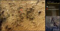
I would like you guys, our resident geologists to drop some of your educated words on this image (original image has been replaced):
-What's your take on the kind of process that may have lead to the formation of a landscape like this? -There are two splat-like features, near the images' equator, one on the left another on the right, what might these be? Thanks for thinking about it! -------------------- "Ride, boldly ride," The shade replied, "If you seek for Eldorado!"
Edgar Alan Poe |
|
 |
 
|
|
|
Oct 7 2008, 04:44 PM
Post
#32
|
|
 Member Group: Members Posts: 239 Joined: 18-December 07 From: New York Member No.: 3982 |
Is Exploratorium backed-up again? They don't have any Bonestell images after sol 1671, even though the tracking site says several additional sections have been downlinked. It corresponds to the Bonestell chart at the very bottom of the tracking data page if that makes any sense.
|
|
|
|
|
Oct 7 2008, 06:00 PM
Post
#33
|
|
|
Senior Member Group: Members Posts: 1074 Joined: 21-September 07 From: Québec, Canada Member No.: 3908 |
QUOTE (ustrax @ Oct 7 2008, 06:07 AM)  I would like you guys, our resident geologists to drop some of your educated words on this image (original image has been replaced): What is the scale of the main image. Is it at the same scale as the Columbia Hills image beside it? My guess would be that the small knobs (including the one in the red square) are made of more resistant rock that was left over after a period of erosion. |
|
|
|
|
Oct 7 2008, 06:21 PM
Post
#34
|
|
|
Solar System Cartographer Group: Members Posts: 10145 Joined: 5-April 05 From: Canada Member No.: 227 |
Rui, normally for a reliable interpretation, you would need to indicate the scale and also show the context of the image - where is it, what's around it? That makes a big difference to a geological interpretation.
I would guess that the area is an old deposit of some kind that is being eroded away, leaving all these little hills as erosional remnants, and that the features you highlight are exhumed impact craters. But it's only a guess. At this resolution it's not really possible to say they are like Home Plate, and they look more like hollows than 'plates' even if one side has an outer scarp - I'd explain that as part of the layer beibng stripped away. Phil -------------------- ... because the Solar System ain't gonna map itself.
Also to be found posting similar content on https://mastodon.social/@PhilStooke NOTE: everything created by me which I post on UMSF is considered to be in the public domain (NOT CC, public domain) |
|
|
|
|
Oct 7 2008, 06:27 PM
Post
#35
|
|
 Senior Member Group: Members Posts: 1887 Joined: 20-November 04 From: Iowa Member No.: 110 |
QUOTE (briv1016 @ Oct 7 2008, 11:44 AM) Is Exploratorium backed-up again? They don't have any Bonestell images after sol 1671, even though the tracking site says several additional sections have been downlinked. It corresponds to the Bonestell chart at the very bottom of the tracking data page if that makes any sense. Spirit has been downloading thumbnails only of the Bonestell pan. Guessing here, downloading just thumbnails saves enough energy for Spirit to image an extra position in the panorama per working sol. This will allow the panorama to be finished earlier so Spirit can move from its current position. The remaining images can be downloaded later. |
|
|
|
|
Oct 7 2008, 06:33 PM
Post
#36
|
|
|
Special Cookie Group: Members Posts: 2168 Joined: 6-April 05 From: Sintra | Portugal Member No.: 228 |
QUOTE (charborob @ Oct 7 2008, 07:00 PM) What is the scale of the main image. Is it at the same scale as the Columbia Hills image beside it? My guess would be that the small knobs (including the one in the red square) are made of more resistant rock that was left over after a period of erosion. charborob, yes the scale is the same for both images. Found a possible analogue from HiRISE: PSP_008778_1685 The explanation given is that...there is not an explanation yet, only guesses, like yours...  "But how did the rocks form, and why did they erode onto mounds? It could have been lava or impact ejecta or fluvial sediments, perhaps altered and indurated by groundwater. The mounds could be due to how it was deposited like hummocky impact ejecta or how it was indurated. In other words, we haven't solved the mystery!" EDITED: Phil, your answer arrived while I was writing, yes you are right, it is better to show the whole picture... Here you have it! The area I've cropped is located south of Thira. 
-------------------- "Ride, boldly ride," The shade replied, "If you seek for Eldorado!"
Edgar Alan Poe |
|
|
|
|
Oct 7 2008, 06:39 PM
Post
#37
|
|
|
Member Group: Members Posts: 688 Joined: 20-April 05 From: Sweden Member No.: 273 |
The "splat-like" features look like they might be melt-sheets from under old craters that have been eroded away.
|
|
|
|
|
Oct 7 2008, 09:28 PM
Post
#38
|
|
|
Senior Member Group: Members Posts: 3516 Joined: 4-November 05 From: North Wales Member No.: 542 |
Aah - your bigger image shows that your two splat features have a much bigger cousin to the north, not far below the south rim of Thira. I would agree that something has caused the impact craters of a certain age in this region to have floors that are cemented in some way and thus erosion resistant. I wouldn't like to guess whether the cementing process is melting per se or something else.
|
|
|
|
|
Oct 7 2008, 10:20 PM
Post
#39
|
|
|
Special Cookie Group: Members Posts: 2168 Joined: 6-April 05 From: Sintra | Portugal Member No.: 228 |
There seems to be some related information at THEMIS website:
"Lobes of a smooth material appear to have flowed, perhaps as water-rich sediments or molten lava, across an older, knobby landscape. The older surface is spotted by its pits, knobs, buttes, and mesas. The knobs may have been eroded by winds into fluted shapes called yardangs that trend northwest-southeast." "The material (south of the Columbia Hills) partly resembles the rough, knobby terrain located on the southeast floor of Gusev. If it has the same origin, then here THEMIS may be looking through a "window" opened by erosion that gives a view down to the older knobby material that is better exposed to the east." I presume this knobby material is the one we're talking about? -------------------- "Ride, boldly ride," The shade replied, "If you seek for Eldorado!"
Edgar Alan Poe |
|
|
|
|
Oct 8 2008, 09:40 AM
Post
#40
|
||
|
Special Cookie Group: Members Posts: 2168 Joined: 6-April 05 From: Sintra | Portugal Member No.: 228 |
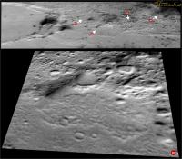
I've tried to had some perspective to the area (nothing that accurate...):
But it changed my point of view about some features, for instance, the oversized Home Plate (03) seems from this angle to be another mesa-like as others surrounding it, the splat like feature to the left (01) looks like the mentioned cemented crater floor, the one to right (04)...don't what what to think of it, seems to be higher than its surroundings, is this consistent with an old crater floor (EDITED: Now looking better it looks like there's a wall to the right that could be a remnant of a crater...)? Another feature caught my attention (02), it appears to my eyes as some sort of cone but it is probably just a optical illusion... EDITED: It wouldn't hurt asking SS if an HiRISE image of this area is planned... "We currently have all the HiRISE images we need to plan Spirit's operations for the coming martian year." Why?! Why?!  Huumm..."for the current martian year"?...Huumm...
-------------------- "Ride, boldly ride," The shade replied, "If you seek for Eldorado!"
Edgar Alan Poe |
|
|
|
|
|
|
Oct 17 2008, 03:15 AM
Post
#41
|
|
|
Senior Member Group: Members Posts: 1887 Joined: 20-November 04 From: Iowa Member No.: 110 |
Spirit imaging has been limited mainly to taking images of the sky recently. Could the storm near the Phoenix site be affecting power levels?
|
|
|
|
|
Oct 20 2008, 03:46 PM
Post
#42
|
|
|
Member Group: Members Posts: 239 Joined: 18-December 07 From: New York Member No.: 3982 |
Two new updates:
sol 1690-1694, October 03-08, 2008: Spirit's Memory Is Getting Full http://marsrovers.jpl.nasa.gov/mission/sta...ll.html#sol1690 sol 1695-1701, October 09-15, 2008: Getting Ready to Make the Next Move http://marsrovers.jpl.nasa.gov/mission/sta...ll.html#sol1695 Of note: QUOTE Instead of sending data only every fourth day, Spirit will begin relaying data every day to NASA's Odyssey orbiter for transmission to Earth.
|
|
|
|
|
Oct 20 2008, 04:18 PM
Post
#43
|
|
|
Senior Member Group: Moderator Posts: 4279 Joined: 19-April 05 From: .br at .es Member No.: 253 |
... and also:
QUOTE Spirit has finished the 360-degree, full-color view of its winter surroundings, known as the "Bonestell panorama," and acquired extra frames at super resolution to enhance details in the imagery.
|
|
|
|
|
Oct 20 2008, 05:29 PM
Post
#44
|
|
 Interplanetary Dumpster Diver Group: Admin Posts: 4404 Joined: 17-February 04 From: Powell, TN Member No.: 33 |
YES!!!! Now to get it on the ground
-------------------- |
|
|
|
|
Oct 23 2008, 06:11 AM
Post
#45
|
||
 Senior Member Group: Admin Posts: 3108 Joined: 21-December 05 From: Canberra, Australia Member No.: 615 |
Did anyone notice that Spirit's IDD is now stowed.
It's been off the hook for a long time...now that the Bonestall pan is done, maybe it's time for her to get moving as well! Any news...anyone?
|
|
|
|
|
|
|

|
Lo-Fi Version | Time is now: 16th April 2024 - 01:55 PM |
|
RULES AND GUIDELINES Please read the Forum Rules and Guidelines before posting. IMAGE COPYRIGHT |
OPINIONS AND MODERATION Opinions expressed on UnmannedSpaceflight.com are those of the individual posters and do not necessarily reflect the opinions of UnmannedSpaceflight.com or The Planetary Society. The all-volunteer UnmannedSpaceflight.com moderation team is wholly independent of The Planetary Society. The Planetary Society has no influence over decisions made by the UnmannedSpaceflight.com moderators. |
SUPPORT THE FORUM Unmannedspaceflight.com is funded by the Planetary Society. Please consider supporting our work and many other projects by donating to the Society or becoming a member. |
|