foldable map of Itokawa, a cook's tour of the sausage factory |

  |
foldable map of Itokawa, a cook's tour of the sausage factory |
 Jan 23 2010, 03:39 AM Jan 23 2010, 03:39 AM
Post
#1
|
|||
|
Member  Group: Members Posts: 140 Joined: 20-November 07 Member No.: 3967 |
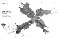
Not that I mean to compare Itokawa to a sausage, just to show you behind the scenes of making the map, along with the map itself, here, rather than continue to clog up the Hayabusa Return to Earth thread.
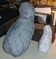
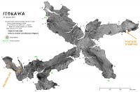
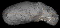
Here is the map itself, so far along as the pasting in of the mosaic has gone. And here is are two shots of the folded up map, compared with the computer-made model. Note the arrow to one of the "ears." The first try of the map failed to capture the ear, so I replotted the boundary, as seen in the Tracing image. All photos credit: Sara Adkins Studio
Attached thumbnail(s)
|
||
 |
 
|
||
|
Jan 23 2010, 03:42 AM
Post
#2
|
|||
|
Member Group: Members Posts: 140 Joined: 20-November 07 Member No.: 3967 |
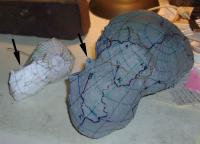
Okay, ran out of file space on that post. Here are the Tracing and the Ear Failure images.
The tracing is taken full-size on acetate directly off the plastic model. The folded map is reduced half size.
Attached thumbnail(s)
|
||
|
|
|
||
|
Jan 23 2010, 03:45 AM
Post
#3
|
||
|
Member Group: Members Posts: 140 Joined: 20-November 07 Member No.: 3967 |
And here is a shot of the work lab where this all happens. Yes, that's a Japanese-made Mutoh magtop cover on the vertical drafting board. I'll post the map with the full mosaic tomorrow. Then, the race begins to put it together!
Attached thumbnail(s)
|
|
|
|
|
|
|
Jan 23 2010, 03:54 AM
Post
#4
|
|
|
Solar System Cartographer Group: Members Posts: 10146 Joined: 5-April 05 From: Canada Member No.: 227 |
Now that's what I call a workshop, Chuck! My office at UWO looks similar - I have to meet students elsewhere so we have somewhere to sit.
Phil -------------------- ... because the Solar System ain't gonna map itself.
Also to be found posting similar content on https://mastodon.social/@PhilStooke NOTE: everything created by me which I post on UMSF is considered to be in the public domain (NOT CC, public domain) |
|
|
|
|
Jan 24 2010, 07:39 PM
Post
#5
|
|
|
Member Group: Members Posts: 140 Joined: 20-November 07 Member No.: 3967 |
Phil,
I'll have to expand the mosaic. Just off-panorama to the right is a mid-century dentist's chair for clients to sit while I draw their house plans, a reminder for them that the process of designing a home is not so much like shopping on Fifth Avenue as it is like getting a root canal. |
|
|
|
|
Jan 24 2010, 07:56 PM
Post
#6
|
|||
|
Member Group: Members Posts: 140 Joined: 20-November 07 Member No.: 3967 |
Well, so much for one more day. The mosaic has a glitch!
One of the small pleasures of pasting in the postage-stamp-sized pieces of the mosaic is watching the squirrely parts unscramble. This is fairly straightforward at the poles, and full of surprises at an asteroid's extreme contours. These have all resolved themselves with the notable exception of the "sea otter's" right neck, the orange circle. How I have it -- and i broke it down into 3.3 degree graticles -- can't be how it ought to look, yet I can't seem to find my mistake(s). The problem might be in my hand-drawn graticles on the model, but I don't see how I'm far enough off to correct the squirreling. Suggestions welcome. I've also got a mundane glitch at the orange arrow -- one of the postage-stamps pooched out the back of the active layer when I wasn't looking. Then, before I caught the goof, I merged the layer with the main mosaic. It's in one of the extreme contour areas, so I may have to rebuild the whole 10x10 degree "square." This thing is gonna be wonderful when I can get a true-color mosaic . . . anybody out there working on that?
Attached thumbnail(s)
|
||
|
|
|
||
|
Jan 24 2010, 09:47 PM
Post
#7
|
|
|
Solar System Cartographer Group: Members Posts: 10146 Joined: 5-April 05 From: Canada Member No.: 227 |
Very interesting, Chuck, and there is a good reason for this. The cylindrical projection map assumes there is a unique location on the surface for any latitude-longitude coordinate pair. But at the location you are having trouble with, this breaks down for Itokawa - the surface is so irregular that a radius from the center of mass cuts the surface more than once. It's a well known cartographic problem for mapping irregular shapes, and it occurs on other bodies too. Your method independently discovers it. In this area of my map the image is messed up, but in a future version it could be fudged a bit better.
Phil -------------------- ... because the Solar System ain't gonna map itself.
Also to be found posting similar content on https://mastodon.social/@PhilStooke NOTE: everything created by me which I post on UMSF is considered to be in the public domain (NOT CC, public domain) |
|
|
|
|
Jan 24 2010, 11:54 PM
Post
#8
|
|
|
Senior Member Group: Members Posts: 1582 Joined: 14-October 05 From: Vermont Member No.: 530 |
Just wait until we find that Mobius-shaped asteroid. You guys will be soooo screwed.
|
|
|
|
|
Jan 24 2010, 11:59 PM
Post
#9
|
||
|
Member Group: Members Posts: 140 Joined: 20-November 07 Member No.: 3967 |
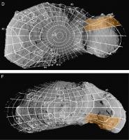
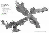
QUOTE (Phil Stooke @ Jan 24 2010, 04:47 PM)  Very interesting, Chuck, and there is a good reason for this. The cylindrical projection map assumes there is a unique location on the surface for any latitude-longitude coordinate pair. But at the location you are having trouble with, this breaks down for Itokawa - the surface is so irregular that a radius from the center of mass cuts the surface more than once. It's a well known cartographic problem for mapping irregular shapes, and it occurs on other bodies too. Your method independently discovers it. In this area of my map the image is messed up, but in a future version it could be fudged a bit better. Phil Oh. Well, so there ya go. Although I don't think the constant-scale natural boundary method discovered it so much as it failed to correct it. If anything can be said for the CSNB method in regard to this sort of problem, I venture to say, is that CSNB -- because it works inward from the edge, capturing true shapes -- is not susceptible to the problem. And nevertheless, I still need unscrambled info to fit into these three graticles, shown in orange on this page from the Icarus Itokawa article. Can you go into the Gaskell shape model and spin it around until you get a nice, straight-on-as-you-can pic of each "square"? That'll be better than what I've got so far.
Attached thumbnail(s)
|
|
|
|
|
|
|
Jan 25 2010, 12:21 AM
Post
#10
|
|
|
Solar System Cartographer Group: Members Posts: 10146 Joined: 5-April 05 From: Canada Member No.: 227 |
I'll see what I can find tomorrow.
"Just wait until we find that Mobius-shaped asteroid. You guys will be soooo screwed. " No - just a cylindrical projection with a twist! Phil -------------------- ... because the Solar System ain't gonna map itself.
Also to be found posting similar content on https://mastodon.social/@PhilStooke NOTE: everything created by me which I post on UMSF is considered to be in the public domain (NOT CC, public domain) |
|
|
|
|
Jan 25 2010, 01:15 AM
Post
#11
|
|
|
Member Group: Members Posts: 140 Joined: 20-November 07 Member No.: 3967 |
"No - just a cylindrical projection with a twist!"
Tee hee. Steveliva, I'm afraid you've already gotten your wish -- it's these lumpy asteroids that are giving the standard cylindrical projections fits. Just look at the discombobulation that Itokawa's overhanging "cheekbone" causes. |
|
|
|
|
Jan 25 2010, 02:13 PM
Post
#12
|
|
|
Solar System Cartographer Group: Members Posts: 10146 Joined: 5-April 05 From: Canada Member No.: 227 |
This is primarily for Chuck, but I'll post it here as others may be interested in the images.
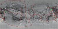
Chuck - check out this site: http://hayabusa.sci.isas.jaxa.jp/shape.pl It contains the rendered images I used for mapping. I superimposed the lat-long grid from a published paper on the shape, and used that as control to reproject the various views to cylindrical, then combined them. This page includes some images I did not use, and they might work for you. I don't have a model I can rotate to any view. I see two images in particular (view 4, view 6) that look obliquely into the weird areas you need to fix up. This is the only suggestion I have right now. Phil -------------------- ... because the Solar System ain't gonna map itself.
Also to be found posting similar content on https://mastodon.social/@PhilStooke NOTE: everything created by me which I post on UMSF is considered to be in the public domain (NOT CC, public domain) |
|
|
|
|
Jan 25 2010, 02:25 PM
Post
#13
|
||
|
Member Group: Members Posts: 140 Joined: 20-November 07 Member No.: 3967 |
"I'll see what I can find tomorrow."
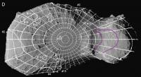
Phil, [EDIT, after Phil's last post] Oh. Nevermind. Maybe something will turn up in Houston. Can you produce the squares in something approximating the "high contrast" look of the cylindrical map? Can you produce the squares both with and without graticle lines? That way I can get a nice clean cut from the "without" square, and still use the "with" square to lock in the registration. And, if you've time for another request, can you use the Gaskell shape model to check my latitudes on Itokawa's chin? See the pic; the magenta lines are my guesses for the 23.333 and 26.667 latitudes. It's pretty tricky, because of the chin's extreme elongation, to locate where these latitudes emerge at the surface. Can you plot these for the areas I show? Some of my concern here (see the constant-scale natural boundary map) may be from pixel resolution. I had to stretch (enlarge) these squares by a factor of 5 from the cylindrical map. (At the poles, of course, the cylindrical map was way more pixels than I needed.) For most of the rest of the asteroid, the cylindrical map held about as many pixels as the corresponding area on the CSNB map. But under the chin, especially, higher resolution would make for a crisper image than what we've got so far. I've got to get hold of software that'll let me open and work with these digital shape models. Any suggestions?
Attached thumbnail(s)
|
|
|
|
|
|
|
Jan 25 2010, 08:11 PM
Post
#14
|
|||
|
Member Group: Members Posts: 140 Joined: 20-November 07 Member No.: 3967 |
Okay. that wasn't so difficult.
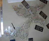
I took this image that Phil steered me to, marked by eye the graticles, and then cut the white-outlined postage stamp (didn't bother to follow the goofy longitude line) and pasted it into the constant-scale natural boundary map. Then it took some heavy fiddling to warp and match it with the rest of the map; not perfect, but it'll do until we get more accurate base material to work with. I don't have Phil's touch on the Photoshop's LEVELS adjustment, so I may have it too washed out; until someone gets it put together we won't know how it matches at the map boundary. Also gonna be a learning experience to see how the repaired right "ear" goes together; fingers are crossed. I used the clone stamp the clean up the postage stamping (at the other end of the map); didn't seem worth it to do anything fussier until we see how the mosaic matches up with itself when the thing is put together. I've posted a larger image of the map over at my website.
Attached thumbnail(s)
|
||
|
|
|
||
|
Feb 1 2010, 07:30 PM
Post
#15
|
||
|
Member Group: Members Posts: 140 Joined: 20-November 07 Member No.: 3967 |
Here are the tabs I'm gonna try this time -- I neglected to keep track of the tabs I used to fold up the grid-only map.
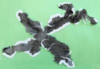
The general rule I use when deciding whether to cut on the map-edge or leave a tab attached is to begin at any random "spot," i.e., the triple junctions (solid circles marked by letters) and the hinge points (open circles marked by numbers), and then switch (from cutting map-edge to leaving a tab) when I arrive at the next "spot." This give a nice interweaving of tabs when assembling, and it seems to work out automatically, so you don't have to strain to think too far ahead about which edge will eventually match with which edge. This alternating tab-or-edge scissoring method means that there are basically only two possible tab layouts -- this always surprises me, but perhaps it is not news to mathematicians? One may be preferable over the other when it comes to assembling the tricky parts, the neck and the two, right-side "ears." Or the tab-and-edge rule may be better not followed in these areas; we don't know yet. When cutting edges and tabs, check yourself where it's easy to do, though; it took me an hour or so to cut this out, and if I had missed a spot-changeover, then during assembly things would be all fouled up -- tabs matching tabs and no tabs matching no tabs -- not a fun outcome. Seam slices -- to use Emily's vividly descriptive phrase -- are NOT shown. I'll use this cutout to keep track of minimum required slices and re-post it. I can do that because I'm learning the hard way not to print (11x17 size, by the way, in case you lost track) the image on standard color-copy paper. It's too shiny for Scotch tape to stick well; I have to print and cut out another. Be patient, that's gonna take me a few days because my good printer (Canon i9900) is on the blitz -- color is all screwed up and I'm at a loss how to fix it. I pinched pennies on my last ink cartridge order, going for the less-expensive Canon-compatible inks. I now have a mix of Canon and generic in it, which may be the source of my problem; or maybe the photo inks are fugitive, and -- I temporarily had the printer set up where it got afternoon sun -- the inks got bleached? Then again, maybe I have to haul it into the shop. Anybody have any experience with this? By the way, since many of the hinge points (the numbered points) swing very narrow arcs, I had to place the numbers far up-stream of the points themselves. Other option was to shrink the font to ultra-teeny and put it in the open circles, but then unreadable. Why do you need them? The cylindrical map is marked correspondingly, so the numbers (and letters) help with orientation if you find yourself working back and forth from the conventional projection and the constant-scale natural boundary projection. And, one final tip, when cutting into those narrow-arc hinge points: forget the alternating tab-and-edge rule; cut whichever side is easiest. I hold scissors in my right hand, so I cut the left side (working toward the hinge point) of the boundary. I see what I'm cutting rather than cutting blind. Photo credit: Sara Adkins Studio / C. Clark
Attached thumbnail(s)
|
|
|
|
|
|
|

|
Lo-Fi Version | Time is now: 19th April 2024 - 08:58 PM |
|
RULES AND GUIDELINES Please read the Forum Rules and Guidelines before posting. IMAGE COPYRIGHT |
OPINIONS AND MODERATION Opinions expressed on UnmannedSpaceflight.com are those of the individual posters and do not necessarily reflect the opinions of UnmannedSpaceflight.com or The Planetary Society. The all-volunteer UnmannedSpaceflight.com moderation team is wholly independent of The Planetary Society. The Planetary Society has no influence over decisions made by the UnmannedSpaceflight.com moderators. |
SUPPORT THE FORUM Unmannedspaceflight.com is funded by the Planetary Society. Please consider supporting our work and many other projects by donating to the Society or becoming a member. |
|