Printable Version of Topic
Click here to view this topic in its original format
Unmanned Spaceflight.com _ Juno _ Juno Perijove 25
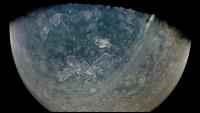
Posted by: Brian Swift Feb 18 2020, 11:47 PM
Preliminary PJ25_18. Exaggerated color/contrast.
|
Posted by: Gerald Feb 19 2020, 02:41 AM
Links to some PJ25, part1 renditions:
- http://junocam.pictures/gerald/uploads/20200219/,
- http://junocam.pictures/gerald/uploads/20200219a/,
- http://junocam.pictures/gerald/uploads/20200219b/,
- http://junocam.pictures/gerald/uploads/20200219c/.
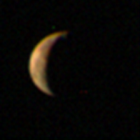
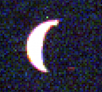
Posted by: Gerald Feb 19 2020, 02:49 AM
Btw, here is a crop #002 to a presumed partial eclipse of one of the moons:
|
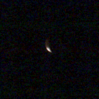
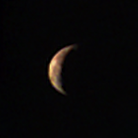
Posted by: volcanopele Feb 19 2020, 04:27 AM
|
JunoCam image of Io from a distance of 199,700 km. A volcanic plume is visible near the top of the crescent, just past the terminator from Chalybes Regio (one of the larger, ongoing eruptions on Io)
The image Gerald just posted is from 10 minutes later, just as Io entered Jupiter's shadow.
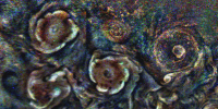
Posted by: Gerald Feb 19 2020, 02:21 PM
One of the anticyclones between the northern CPCs and the north polar cyclone is well-resolved this time. Here a blink showing its rotation, as well as that of some of the CPCs:
|
Note the apparent anticyclonic rotation in the core of the bottom center CPC.
Posted by: Kevin Gill Feb 19 2020, 04:41 PM
Found the Chalybes Regio plume at top of PJ25-1. Cranked the brightness, found another candidate but not convinced that's what it is.
|
|
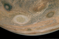
Posted by: Bjorn Jonsson Feb 24 2020, 11:47 PM
This is a mosaic of images PJ25_25 and PJ25_27 rendered from Juno's position when it was acquiring image PJ25_27. Approximately true color/contrast and enhanced versions:

|
|
The oval left of center is known as NN-WS-4 and is located at planetographic latitude ~41.5 degrees north. It is ~7000 km across.
This is a very wide angle mosaic, the field of view is 94 degrees. North is up.
Posted by: Sean Feb 25 2020, 01:55 AM
Jupiter - Here Be Dragons...
PJ25_24 Eichstadt / Doran
https://flic.kr/p/2ixoaL9
Detail...
https://flic.kr/p/2ixyCGd
Posted by: Kevin Gill Feb 27 2020, 04:44 PM
For some reason, I'm loving the views of the South Equatorial Belt in this perijove. Nice and clear overview shots with tons of eddies and turbulence. I just wish Juno could get the GRS from this perspective...
https://flic.kr/p/2iya3re
https://flic.kr/p/2iya3re
https://flic.kr/p/2iy3D3h
https://flic.kr/p/2iy3D3h
https://flic.kr/p/2ixEHhU
https://flic.kr/p/2ixEHhU
Posted by: Sean Feb 27 2020, 06:54 PM
Beautiful!
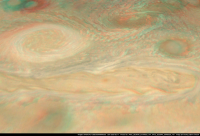
Posted by: Bjorn Jonsson Apr 12 2020, 01:42 PM
Images obtained with JunoCam's methane filter can be used to estimate the relative altitudes of Jupiter's clouds. Features that appear bright in the methane images are high in the atmosphere whereas darker features are located at lower altitudes.This is an experimental anaglyph created by using image PJ25_26 (a methane image) to generate a digital elevation model (DEM) of Jupiter's clouds. A slightly enhanced version of image PJ25_25 (a normal color image) was then draped over the DEM. This turned out way better than I expected. Here it is assumed that the cloud altitudes are a linear function of brightness in the methane image. This assumption is not accurate but is nevertheless good enough to result in a nice DEM and anaglyph. Elevation differences are exaggerated. As expected, the resulting image shows that bright features tend to be higher in the atmosphere than dark features. Red-blue glasses are needed to view this image properly.
|
Posted by: john_s Apr 12 2020, 04:25 PM
I like it- nice job!
John
Posted by: Bjorn Jonsson May 19 2021, 11:13 PM
The long and narrow haze bands often seen at high northern latitudes are especially conspicuous in the PJ25 images. I recently saw a Landsat 8 image that might be of peripheral interest when looking at JunoCam's images of Jupiter's haze bands. I'm attaching a montage showing JunoCam image PJ25_18 at left and the Landsat image at right.
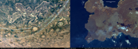
|
What the images have in common is that they both show haze that looks slightly bluish and in both cases the haze apparently casts brownish shadows on what's below.
The Landsat image at right in the montage was obtained by Landsat 8 on May 9, 2021. It is processed from bands 4, 3 and 2 (red/green/blue) and includes the site of the ongoing Geldingadalir volcanic eruption in Iceland. The volcanic plume containing sulphur dioxide (SO2) among other things is clearly visible; clouds and hazes associated with it extend to the west (or WSW). The Landsat image is slightly enhanced to better show the plume and the shadows and the color saturation was also increased. The JunoCam image is much more heavily processed.
This comparison between JunoCam and Landsat images was inspired by a Facebook post from the Volcanology and Natural Hazard Group at the University of Iceland which posted a different version of this Landsat image (different bands were used) and mentioned the bluish haze and yellowish/brownish shadows from the plume. This particular Facebook post is here:
https://www.facebook.com/Natturuva/posts/2901017770112311
Powered by Invision Power Board (http://www.invisionboard.com)
© Invision Power Services (http://www.invisionpower.com)