HiRISE DEM's |

HiRISE DEM's |
 Apr 13 2008, 10:46 AM Apr 13 2008, 10:46 AM
Post
#121
|
|||
|
Founder  Group: Chairman Posts: 14432 Joined: 8-February 04 Member No.: 1 |
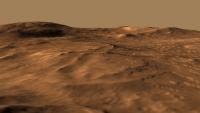
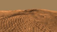
Late last week I stumbled upon a few HiRISE derived DEM's (Randy Kirk works his magic once again!)
http://webgis.wr.usgs.gov/ftphirise/index.jsp (URL now down) I'm working on both Vic Crater and the Columbia Hills. Fortunately, now I've got a Mac, I can use ISIS. I've figured out a fairly simple flow ( isis2raw as 16 bit unsigned, and then imported into Photoshop ) to take DEM CUB's and make 16 bit PNG's  Just to demo how important that is for me as an animator - sliced comparisons of 8bit vs 16 bit. A busy week unfortunately, but animations of various sorts are in the pipeline.
Attached thumbnail(s)
|
||
 |
 
|
||
 djellison HiRISE DEM's Apr 13 2008, 10:46 AM
 Mars3D Hi JRA,
I have 4GB of ram (only 3GB is usable bec... Nov 25 2010, 07:36 PM
Mars3D Hi JRA,
I have 4GB of ram (only 3GB is usable bec... Nov 25 2010, 07:36 PM
 JRA Hey, thanks for the reply and information. I think... Nov 26 2010, 06:25 AM RRussman These are all great visualizations of the HiRISE e... Aug 22 2013, 06:45 PM djellison Any HiRISE DTM (and I assume HRSC DTM ) gets match... Aug 22 2013, 07:19 PM RoverDriver RRussman, each DTM is ortho rectified an as such t... Aug 22 2013, 07:48 PM Phil Stooke One lesson to take from this is that DEMs and asso... Aug 22 2013, 07:48 PM RRussman Doug, Im pretty sure everything is matched to MOL... Aug 24 2013, 11:35 PM
  |

|
Lo-Fi Version | Time is now: 16th May 2024 - 07:47 AM |
|
RULES AND GUIDELINES Please read the Forum Rules and Guidelines before posting. IMAGE COPYRIGHT |
OPINIONS AND MODERATION Opinions expressed on UnmannedSpaceflight.com are those of the individual posters and do not necessarily reflect the opinions of UnmannedSpaceflight.com or The Planetary Society. The all-volunteer UnmannedSpaceflight.com moderation team is wholly independent of The Planetary Society. The Planetary Society has no influence over decisions made by the UnmannedSpaceflight.com moderators. |
SUPPORT THE FORUM Unmannedspaceflight.com is funded by the Planetary Society. Please consider supporting our work and many other projects by donating to the Society or becoming a member. |
|