The Top of Vera Rubin Ridge Part 2, Site 67-73, sol 1944-2297, 24 Jan 2018-22 Jan 2019 |

  |
The Top of Vera Rubin Ridge Part 2, Site 67-73, sol 1944-2297, 24 Jan 2018-22 Jan 2019 |
 Feb 10 2018, 11:07 AM Feb 10 2018, 11:07 AM
Post
#31
|
|
 Senior Member  Group: Members Posts: 1619 Joined: 12-February 06 From: Bergerac - FR Member No.: 678 |
Sol 1957 (and 1959, one frame) panoramic.
-------------------- |
 |
 
|
|
Feb 12 2018, 09:18 AM
Post
#32
|
|
 Senior Member Group: Members Posts: 2431 Joined: 30-January 13 From: Penang, Malaysia. Member No.: 6853 |
Looks like they have completed the long awaited drive to the NE on 1962, path looks like a dogs leg, but the point to point may be around 50m. Still playing with ICE
 |
|
|
|
|
Feb 12 2018, 11:33 AM
Post
#33
|
|
 Member Group: Members Posts: 819 Joined: 3-June 04 From: Brittany, France Member No.: 79 |
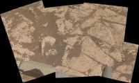
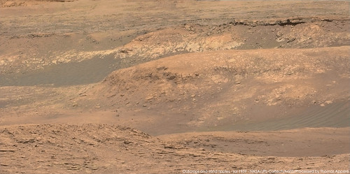
I stitched a couple of MC100 pictures focusing on the foothills and outcrops on sol 1957 and 1959. Photos are taken at ~12h local time, so not a lot of contrast.
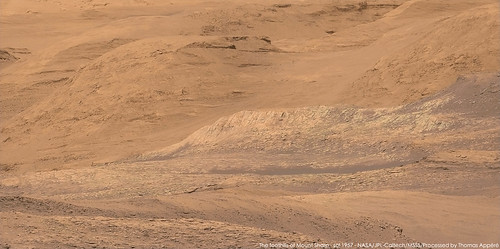   I also combined a recent RMI mosaic taken on sol 1961 with a MC100 picture to show the location of the outcrop that was imaged: 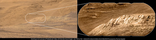
-------------------- |
|
|
|
|
Feb 12 2018, 07:39 PM
Post
#34
|
|
|
Solar System Cartographer Group: Members Posts: 10226 Joined: 5-April 05 From: Canada Member No.: 227 |
Great pictures, everybody - what an amazing place we are coming to! The next few years are going to be spectacular.
Phil -------------------- ... because the Solar System ain't gonna map itself.
Also to be found posting similar content on https://mastodon.social/@PhilStooke Maps for download (free PDF: https://upload.wikimedia.org/wikipedia/comm...Cartography.pdf NOTE: everything created by me which I post on UMSF is considered to be in the public domain (NOT CC, public domain) |
|
|
|
|
Feb 13 2018, 11:48 AM
Post
#35
|
|
|
Senior Member Group: Members Posts: 1619 Joined: 12-February 06 From: Bergerac - FR Member No.: 678 |
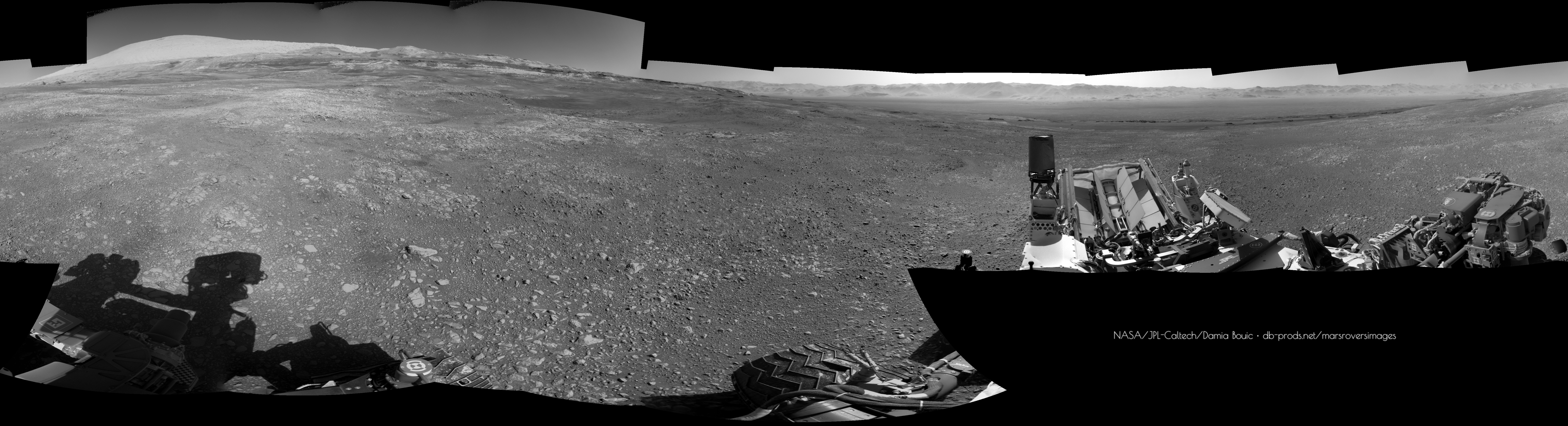
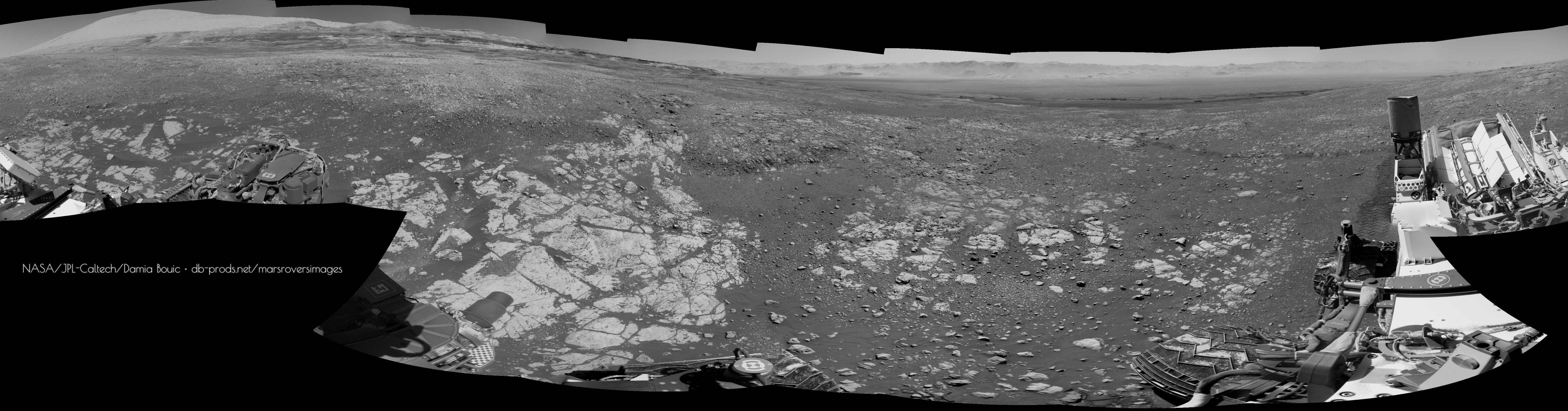
Sol 1962 Navcam pan :
-------------------- |
|
|
|
|
Feb 13 2018, 01:37 PM
Post
#36
|
||
|
Senior Member Group: Members Posts: 2431 Joined: 30-January 13 From: Penang, Malaysia. Member No.: 6853 |
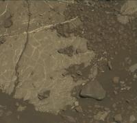
Potential Drill Site?
L-MastCam arm workspace: Sol 1962 (MS ICE) minimal processing, some nice surface details on the exposed bedrock Fingers crossed they get the all clear to drill... Been a while 
|
|
|
|
|
|
|
Feb 13 2018, 04:48 PM
Post
#37
|
|
|
Member Group: Members Posts: 819 Joined: 3-June 04 From: Brittany, France Member No.: 79 |
Gregory Dubos, who works at JPL on Curiosity, recently tweeted (@astroptere) that his team is currently preparing a new drilling attempt.
-------------------- |
|
|
|
|
Feb 13 2018, 08:39 PM
Post
#38
|
||
|
Solar System Cartographer Group: Members Posts: 10226 Joined: 5-April 05 From: Canada Member No.: 227 |
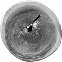
Damia's new panorama for sol 1962 in circular form.
Phil
-------------------- ... because the Solar System ain't gonna map itself.
Also to be found posting similar content on https://mastodon.social/@PhilStooke Maps for download (free PDF: https://upload.wikimedia.org/wikipedia/comm...Cartography.pdf NOTE: everything created by me which I post on UMSF is considered to be in the public domain (NOT CC, public domain) |
|
|
|
|
|
|
Feb 13 2018, 10:55 PM
Post
#39
|
|
|
Senior Member Group: Members Posts: 2431 Joined: 30-January 13 From: Penang, Malaysia. Member No.: 6853 |
QUOTE (neo56 @ Feb 14 2018, 12:48 AM)  Gregory Dubos, who works at JPL on Curiosity, recently tweeted (@astroptere) that his team is currently preparing a new drilling attempt. Good spot Thomas The possibility of using the drill at this location is also addressed in the sol 1963 mission update |
|
|
|
|
Feb 16 2018, 01:56 AM
Post
#40
|
||
|
Senior Member Group: Members Posts: 2431 Joined: 30-January 13 From: Penang, Malaysia. Member No.: 6853 |
The 1965 mission update calls for a 360 MastCam mosaic, maybe to support that they have also acquired a NavCam set of the Rover deck
Should be an impressive panorama from this vantage point.There is also a nice candidate for another iron-nickel meteorite in the arm workspace, the team are going to be here for a while if the ground is suitable to attempt drilling, so maybe they will give it a zap to see if it is iron, I hope the coating on its topside is not dust, maybe wishful thinking that is a ferrous oxide, or maybe where is was in contact with a rock (if it was buried in the sediments)
Attached thumbnail(s)
|
|
|
|
|
|
|
Feb 20 2018, 08:21 PM
Post
#41
|
||
|
Solar System Cartographer Group: Members Posts: 10226 Joined: 5-April 05 From: Canada Member No.: 227 |
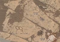
This is part of Paul's workspace mosaic (with a little patch), posted earlier, annotated with recent activities.
Phil
-------------------- ... because the Solar System ain't gonna map itself.
Also to be found posting similar content on https://mastodon.social/@PhilStooke Maps for download (free PDF: https://upload.wikimedia.org/wikipedia/comm...Cartography.pdf NOTE: everything created by me which I post on UMSF is considered to be in the public domain (NOT CC, public domain) |
|
|
|
|
|
|
Feb 21 2018, 10:17 PM
Post
#42
|
|
 Administrator Group: Admin Posts: 5172 Joined: 4-August 05 From: Pasadena, CA, USA, Earth Member No.: 454 |
FYI (from Ashwin), the smaller pile (upper one in your view) is the sieved (fine-grained) sample, the larger pile the unsieved (coarse-grained) sample.
Curiosity update forthcoming. -------------------- My website - My Patreon - @elakdawalla on Twitter - Please support unmannedspaceflight.com by donating here.
|
|
|
|
|
Feb 22 2018, 12:12 AM
Post
#43
|
|
|
Solar System Cartographer Group: Members Posts: 10226 Joined: 5-April 05 From: Canada Member No.: 227 |
Thanks, I was trying to decide which was which.
Phil -------------------- ... because the Solar System ain't gonna map itself.
Also to be found posting similar content on https://mastodon.social/@PhilStooke Maps for download (free PDF: https://upload.wikimedia.org/wikipedia/comm...Cartography.pdf NOTE: everything created by me which I post on UMSF is considered to be in the public domain (NOT CC, public domain) |
|
|
|
|
Feb 23 2018, 09:27 AM
Post
#44
|
|
|
Senior Member Group: Members Posts: 2431 Joined: 30-January 13 From: Penang, Malaysia. Member No.: 6853 |
Go For Drilling at "Lake Orcadie" Link
|
|
|
|
|
Feb 27 2018, 07:40 PM
Post
#45
|
||
|
Solar System Cartographer Group: Members Posts: 10226 Joined: 5-April 05 From: Canada Member No.: 227 |
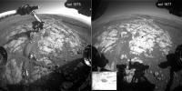
Suffering through a bit of an image diet here, but it looks like we had a successful drill on 1977. Here's a comparison of images 2 sols apart.
Phil
-------------------- ... because the Solar System ain't gonna map itself.
Also to be found posting similar content on https://mastodon.social/@PhilStooke Maps for download (free PDF: https://upload.wikimedia.org/wikipedia/comm...Cartography.pdf NOTE: everything created by me which I post on UMSF is considered to be in the public domain (NOT CC, public domain) |
|
|
|
|
|
|

|
Lo-Fi Version | Time is now: 22nd September 2024 - 12:46 AM |
|
RULES AND GUIDELINES Please read the Forum Rules and Guidelines before posting. IMAGE COPYRIGHT |
OPINIONS AND MODERATION Opinions expressed on UnmannedSpaceflight.com are those of the individual posters and do not necessarily reflect the opinions of UnmannedSpaceflight.com or The Planetary Society. The all-volunteer UnmannedSpaceflight.com moderation team is wholly independent of The Planetary Society. The Planetary Society has no influence over decisions made by the UnmannedSpaceflight.com moderators. |
SUPPORT THE FORUM Unmannedspaceflight.com is funded by the Planetary Society. Please consider supporting our work and many other projects by donating to the Society or becoming a member. |
|