MSL Curiosity Lands Safely in Gale Crater, Landing and Commissioning Activity Period 1A, sols 0-8 |

  |
MSL Curiosity Lands Safely in Gale Crater, Landing and Commissioning Activity Period 1A, sols 0-8 |
 Aug 9 2012, 09:36 AM Aug 9 2012, 09:36 AM
Post
#631
|
|
|
Member  Group: Members Posts: 200 Joined: 20-November 05 From: Mare Desiderii Member No.: 563 |
So... this image (or elakdawalla's brightened version) shows the rover deck with lots of gravel in it. Including inside those light-coloured enclosures, which I assume are the protective lips that protected the mast's "eyes" while it was still stowed on deck.
Do we think the grit got in there before the mast was raised, or fell in during? Could any grit/gravel resting on the mast before it was raised have become lodged anywhere awkward that will cause trouble in future, such as mobility problems? The rovers always look so exposed, but I assume the moving parts / bearings etc are well sealed up. Was this amount / size of debris expected? |
 |
 
|
|
Aug 9 2012, 10:10 AM
Post
#632
|
|
|
Senior Member Group: Members Posts: 2511 Joined: 13-September 05 Member No.: 497 |
QUOTE (JTN @ Aug 9 2012, 01:36 AM)  Do we think the grit got in there before the mast was raised, or fell in during? Before, you can clearly see it in the sol 1 pre-RSM-deploy Mastcam thumbnails. QUOTE Was this amount / size of debris expected? I certainly wasn't expecting it. -------------------- Disclaimer: This post is based on public information only. Any opinions are my own.
|
|
|
|
|
Aug 9 2012, 10:20 AM
Post
#633
|
|
|
Junior Member Group: Members Posts: 57 Joined: 6-September 07 From: Netherlands Member No.: 3683 |
All Navcam Full images are down now, the Mastcam color thumbnails are down to but not on the page yet (MSL RAW Page)
-------------------- Error: Life.sys corrupted
( R )eflect, ( R )epend, or ( R )eboot? |
|
|
|
|
Aug 9 2012, 10:39 AM
Post
#634
|
|
|
Newbie Group: Members Posts: 7 Joined: 13-April 09 Member No.: 4730 |
Is there a way to Wget the raw images from the MSL page? because I tried to do it as I used to dowlonad the Cassini raw images from their site and i'ts not working.
PS: Maybe I'm just doing it wrong because the last time I used Wget was 3 years ago  PS2: During three years I've been a silent reader but an event like this is worth of start participating in the forum. |
|
|
|
|
Aug 9 2012, 11:11 AM
Post
#635
|
|
|
Member Group: Members Posts: 813 Joined: 29-December 05 From: NE Oh, USA Member No.: 627 |
QUOTE (dvandorn @ Aug 9 2012, 12:30 AM) And on an historical note, how many of us who sat around our television sets watching the CBS News live coverage of the close approach of Mariner 7 as it flew by Mars, on August 5, 1969, guessed that 43 years and a day later we'd be watching Curiosity being lowered gently to the ground on a rope?  -the other Doug I was there .... and what a summer that was! Could not have imagined back then all the planetary vistas our proxy probes have sent us since. Never would have imagined this. That we could be so intimately 'THERE' with our creations. Glorious! Craig |
|
|
|
|
Aug 9 2012, 11:55 AM
Post
#636
|
|
 Senior Member Group: Members Posts: 2173 Joined: 28-December 04 From: Florida, USA Member No.: 132 |
QUOTE (walfy @ Aug 9 2012, 01:42 AM) Where the burners blew away the dust, revealing what might be the true bottom of the crater floor: Not the original bottom of the crater. That has almost certainly been covered by a thick bed of layered infill (continuing down from the layers which compose Mt. Sharp). But it would give us our first look at local bedrock -- not windblown global sand and dust or far-flung impact ejecta.Me <--- not an expert. 
|
|
|
|
|
Aug 9 2012, 12:11 PM
Post
#637
|
|
 Member Group: Members Posts: 255 Joined: 4-January 05 Member No.: 135 |
QUOTE (centsworth_II @ Aug 9 2012, 12:55 PM) Not the original bottom of the crater. That has almost certainly been covered by a thick bed of layered infill (continuing down from the layers which compose Mt. Sharp). But it would give us our first look at local bedrock -- not windblown global sand and dust or far-flung impact ejecta. I'd guess that they wouldn't look at the blast pits with any instruments on the arm - the chances of contamination would be too high. The mastcam and chemcam would be ideal though |
|
|
|
|
Aug 9 2012, 12:32 PM
Post
#638
|
|
|
Senior Member Group: Members Posts: 2173 Joined: 28-December 04 From: Florida, USA Member No.: 132 |
QUOTE (chris @ Aug 9 2012, 08:11 AM) I'd guess that they wouldn't look at the blast pits with any instruments on the arm - the chances of contamination would be too high. At the Aug 8 press briefing it was stated that after a few days any contamination from the hydrazine thrusters would dissipate and there was no danger, even of contamination of science results.Edit: Here's the press briefing (just after minute 34) covering the nature of the rock uncovered by the rocket blast, the possibility of contamination and possibility of examination with the arm. |
|
|
|
|
Aug 9 2012, 12:32 PM
Post
#639
|
|
|
Member Group: Members Posts: 242 Joined: 21-December 04 Member No.: 127 |
QUOTE (dvandorn @ Aug 8 2012, 10:30 PM) And on an historical note, how many of us who sat around our television sets watching the CBS News live coverage of the close approach of Mariner 7 as it flew by Mars, on August 5, 1969, guessed that 43 years and a day later we'd be watching Curiosity being lowered gently to the ground on a rope? I vaguely remember the front page of the newspaper when one of the Vikings landed. For me "Mars" really began watching a bunch of "kids" my age (in very un-NASA like attire) in what looked like a spare conference room at JPL waiting to see if a spacecraft in a bouncing ball would work. How did they ever get old? What's amazing to me is that we've gone from thinking how cool it would be to get a closer look at "Twin Peaks" to getting ready to climb a mountain with a freaking nuclear-powered rover in 15 years! That's faster than I would have ever imagined back in 1997. |
|
|
|
|
Aug 9 2012, 12:40 PM
Post
#640
|
|
 Member Group: Members Posts: 813 Joined: 8-February 04 From: Arabia Terra Member No.: 12 |
QUOTE (gpurcell @ Aug 9 2012, 10:32 PM) That's faster than I would have ever imagined back in 1997. Back then I was thinking that there would by now have been one or more successful sample returns starting with Mars Surveyor 2005. Over optimistic, I guess. |
|
|
|
|
Aug 9 2012, 12:51 PM
Post
#641
|
|
|
Member Group: Members Posts: 255 Joined: 4-January 05 Member No.: 135 |
QUOTE (centsworth_II @ Aug 9 2012, 01:32 PM) At the Aug 8 press briefing it was stated that after a few days any contamination from the hydrazine thrusters would dissipate and there was no danger, even of contamination of science results. Thank you! I missed that one Edit: Found it here on C-SPAN |
|
|
|
|
Aug 9 2012, 01:57 PM
Post
#642
|
|
 Senior Member Group: Moderator Posts: 2262 Joined: 9-February 04 From: Melbourne - Oz Member No.: 16 |
More sol 2 navcams, (2D & 3D) looking towards the mountain this time. Not particularly happy with the right eye alignment (still working on understanding all this new stuff!) but it'll have to do for now.
 
-------------------- |
|
|
|
|
Aug 9 2012, 02:06 PM
Post
#643
|
|
 Senior Member Group: Members Posts: 3419 Joined: 9-February 04 From: Minneapolis, MN, USA Member No.: 15 |
You know, I was expecting to be able to see a little height on the dunes in the dark-sand dune field. They cast shadows from the dune peaks in the overhead images, I expected to see a slightly choppy-looking top to them. In these surface images thus far, they look like a dark band painted onto the surface with no real height to them at all.
I understand we're probably five km or more from the near edge of the dune field, but still... is this just a function of our distance from them? Or are the dark-sand dunes not as tall as they look from above? -the other Doug -------------------- The trouble ain't that there is too many fools, but that the lightning ain't distributed right. -Mark Twain
|
|
|
|
|
Aug 9 2012, 02:22 PM
Post
#644
|
|
 Member Group: Members Posts: 699 Joined: 3-December 04 From: Boulder, Colorado, USA Member No.: 117 |
Looking south towards the mountain in the center of James's wonderful mosaic, I see about six different terrain types, all of which we expect to be able to explore. The contrast with previous landing sites, where geological interest had to be so much more compromised by safety concerns, is dramatic. This type of precision landing is really a game-changer.
And does the view to the south remind anyone else of one of the Navajo sandstone "swells" of southern Utah? Mostly a coincidence, but not completely... John |
|
|
|
|
Aug 9 2012, 02:29 PM
Post
#645
|
||
 Member Group: Members Posts: 809 Joined: 3-June 04 From: Brittany, France Member No.: 79 |
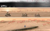
Matching between the panorama of the rim of Gale crater acquired by Curiosity's Navcam and the CTX observations drapped on topography. These last observations have been obtained on Explore Mars : http://mars.jpl.nasa.gov/explore/curiosity/
On the bottom picture, the distance from Curiosity to the various features identified are indicated.
Attached thumbnail(s)
-------------------- |
|
|
|
|
|
|

|
Lo-Fi Version | Time is now: 27th April 2024 - 04:38 AM |
|
RULES AND GUIDELINES Please read the Forum Rules and Guidelines before posting. IMAGE COPYRIGHT |
OPINIONS AND MODERATION Opinions expressed on UnmannedSpaceflight.com are those of the individual posters and do not necessarily reflect the opinions of UnmannedSpaceflight.com or The Planetary Society. The all-volunteer UnmannedSpaceflight.com moderation team is wholly independent of The Planetary Society. The Planetary Society has no influence over decisions made by the UnmannedSpaceflight.com moderators. |
SUPPORT THE FORUM Unmannedspaceflight.com is funded by the Planetary Society. Please consider supporting our work and many other projects by donating to the Society or becoming a member. |
|