MSL Route Map |

  |
MSL Route Map |
 Mar 6 2017, 06:17 PM Mar 6 2017, 06:17 PM
Post
#946
|
||
 Senior Member  Group: Members Posts: 2173 Joined: 28-December 04 From: Florida, USA Member No.: 132 |
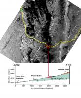
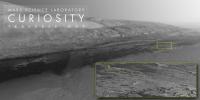
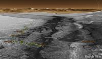
http://marsmobile.jpl.nasa.gov/msl/multime...s/?ImageID=6584 http://marsmobile.jpl.nasa.gov/msl/multime...s/?ImageID=6579 Here is the (rotated) route map compared to the cross-section view with the approximate location of MSL circled in red. |
|
 |
 
|
|
|
Mar 6 2017, 08:46 PM
Post
#947
|
|
|
Senior Member Group: Members Posts: 1276 Joined: 25-November 04 Member No.: 114 |
SO close! Thanks for posting so quick.
This year will be even more exciting! |
|
|
|
|
Mar 7 2017, 12:17 AM
Post
#948
|
||
|
Solar System Cartographer Group: Members Posts: 10151 Joined: 5-April 05 From: Canada Member No.: 227 |
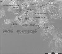
Sol 1628, a drive to the southeast, into the last gap between dunes.
Phil
-------------------- ... because the Solar System ain't gonna map itself.
Also to be found posting similar content on https://mastodon.social/@PhilStooke Maps for download (free PD: https://upload.wikimedia.org/wikipedia/comm...Cartography.pdf NOTE: everything created by me which I post on UMSF is considered to be in the public domain (NOT CC, public domain) |
|
|
|
|
|
|
Mar 8 2017, 04:19 PM
Post
#949
|
||
|
Solar System Cartographer Group: Members Posts: 10151 Joined: 5-April 05 From: Canada Member No.: 227 |
Good progress to the southeast on sol 1630.
Phil
-------------------- ... because the Solar System ain't gonna map itself.
Also to be found posting similar content on https://mastodon.social/@PhilStooke Maps for download (free PD: https://upload.wikimedia.org/wikipedia/comm...Cartography.pdf NOTE: everything created by me which I post on UMSF is considered to be in the public domain (NOT CC, public domain) |
|
|
|
|
|
|
Mar 8 2017, 04:40 PM
Post
#950
|
||
|
Junior Member Group: Members Posts: 32 Joined: 17-April 05 Member No.: 235 |
On 03.08.2017
Attached thumbnail(s)
|
|
|
|
|
|
|
Mar 9 2017, 07:57 PM
Post
#951
|
|
|
Member Group: Members Posts: 923 Joined: 10-November 15 Member No.: 7837 |
Hope this is OK to post here.
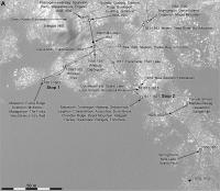
 The link above is a 30K version over at Flickr. Here is the full fat 1.8 gigapixel interactive image over at Gigapan. I referenced the route map compiled by the maestro Phil Stooke as well as the JPL route map. This is my first attempt at piecing together the 9 connected HiRISE DTM's in Curi's corner of Mt Sharp. It was a hefty task given my hardware limitations, I had to divide the composition in 30k x 15k quadrants for each of the elements covered and for each pass on each element ( Alpha, Depth, Route ) All this raw material was compiled through many iterations & image processing in Photoshop in order to recombine into final 60K x 30K image. Curi was composited into the DTM model texture from HiRISE orbital images and the 3D model scaled in situ accordingly. Known issues: Plenty! I will patch up the obvious gap in coverage on the north flank of Mt Sharp. Any suggestions for improving are welcome. -------------------- |
|
|
|
|
Mar 10 2017, 06:53 AM
Post
#952
|
||
|
Senior Member Group: Members Posts: 2173 Joined: 28-December 04 From: Florida, USA Member No.: 132 |
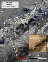
Great work by Sean. To help others find Curiosity's trail in the gigapan I highlighted it and marked Curiosity's approximate location with a yellow circle in the enlarged inset which covers the route from Murray Buttes (lower right). |
|
|
|
|
|
|
Mar 10 2017, 06:39 PM
Post
#953
|
|
 Member Group: Members Posts: 888 Joined: 15-June 09 From: Lisbon, Portugal Member No.: 4824 |
Congratulations Sean! Can't loose that Gigapan link. I'll be refering to it for many years (fingers crossed) while Curiosity makes its way to the end of the white line (and then I'm sure there are other places it can go).
Fernando |
|
|
|
|
Mar 10 2017, 11:43 PM
Post
#954
|
||
|
Solar System Cartographer Group: Members Posts: 10151 Joined: 5-April 05 From: Canada Member No.: 227 |
Nice work, Sean!
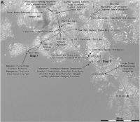
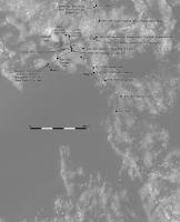
Here's an update to sol 1633, moving through the gap. The location is only based on Hazcams and might be a bit off. EDIT - a bit off? It was really bad. I have replaced the map with a good one. Phil
-------------------- ... because the Solar System ain't gonna map itself.
Also to be found posting similar content on https://mastodon.social/@PhilStooke Maps for download (free PD: https://upload.wikimedia.org/wikipedia/comm...Cartography.pdf NOTE: everything created by me which I post on UMSF is considered to be in the public domain (NOT CC, public domain) |
|
|
|
|
|
|
Mar 11 2017, 12:52 AM
Post
#955
|
||
|
Solar System Cartographer Group: Members Posts: 10151 Joined: 5-April 05 From: Canada Member No.: 227 |
... and a bit more of an overview to show the path ahead for a week or 2. EDIT - also replaced.
Phil
-------------------- ... because the Solar System ain't gonna map itself.
Also to be found posting similar content on https://mastodon.social/@PhilStooke Maps for download (free PD: https://upload.wikimedia.org/wikipedia/comm...Cartography.pdf NOTE: everything created by me which I post on UMSF is considered to be in the public domain (NOT CC, public domain) |
|
|
|
|
|
|
Mar 14 2017, 01:31 AM
Post
#956
|
||
|
Solar System Cartographer Group: Members Posts: 10151 Joined: 5-April 05 From: Canada Member No.: 227 |
Sol 1635 - near the next stop.
Phil
-------------------- ... because the Solar System ain't gonna map itself.
Also to be found posting similar content on https://mastodon.social/@PhilStooke Maps for download (free PD: https://upload.wikimedia.org/wikipedia/comm...Cartography.pdf NOTE: everything created by me which I post on UMSF is considered to be in the public domain (NOT CC, public domain) |
|
|
|
|
|
|
Mar 14 2017, 07:34 PM
Post
#957
|
||
|
Member Group: Members Posts: 888 Joined: 15-June 09 From: Lisbon, Portugal Member No.: 4824 |
Update to sol 1632 plus provisional to sol 1635. Changed the initial point of view.
Fernando
 The_Martian_Way_MSL_Curiosity_Sol_1635_2017MAR14.kmz ( 455.68K )
Number of downloads: 260
The_Martian_Way_MSL_Curiosity_Sol_1635_2017MAR14.kmz ( 455.68K )
Number of downloads: 260 |
|
|
|
|
|
|
Mar 14 2017, 11:27 PM
Post
#958
|
||
|
Solar System Cartographer Group: Members Posts: 10151 Joined: 5-April 05 From: Canada Member No.: 227 |
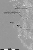
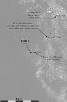
Sol 1636, here we are at Stop 3.
Phil
-------------------- ... because the Solar System ain't gonna map itself.
Also to be found posting similar content on https://mastodon.social/@PhilStooke Maps for download (free PD: https://upload.wikimedia.org/wikipedia/comm...Cartography.pdf NOTE: everything created by me which I post on UMSF is considered to be in the public domain (NOT CC, public domain) |
|
|
|
|
|
|
Mar 17 2017, 05:24 PM
Post
#959
|
||
|
Solar System Cartographer Group: Members Posts: 10151 Joined: 5-April 05 From: Canada Member No.: 227 |
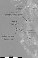
Moving on... I thought we would scoop at Stop 3 but I guess that will be Stop 4 instead.
Phil
-------------------- ... because the Solar System ain't gonna map itself.
Also to be found posting similar content on https://mastodon.social/@PhilStooke Maps for download (free PD: https://upload.wikimedia.org/wikipedia/comm...Cartography.pdf NOTE: everything created by me which I post on UMSF is considered to be in the public domain (NOT CC, public domain) |
|
|
|
|
|
|
Mar 20 2017, 02:46 PM
Post
#960
|
||
|
Solar System Cartographer Group: Members Posts: 10151 Joined: 5-April 05 From: Canada Member No.: 227 |
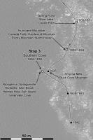
Quick map update to sol 1642 from Paul's panorama.
Phil
-------------------- ... because the Solar System ain't gonna map itself.
Also to be found posting similar content on https://mastodon.social/@PhilStooke Maps for download (free PD: https://upload.wikimedia.org/wikipedia/comm...Cartography.pdf NOTE: everything created by me which I post on UMSF is considered to be in the public domain (NOT CC, public domain) |
|
|
|
|
|
|

|
Lo-Fi Version | Time is now: 25th April 2024 - 09:12 AM |
|
RULES AND GUIDELINES Please read the Forum Rules and Guidelines before posting. IMAGE COPYRIGHT |
OPINIONS AND MODERATION Opinions expressed on UnmannedSpaceflight.com are those of the individual posters and do not necessarily reflect the opinions of UnmannedSpaceflight.com or The Planetary Society. The all-volunteer UnmannedSpaceflight.com moderation team is wholly independent of The Planetary Society. The Planetary Society has no influence over decisions made by the UnmannedSpaceflight.com moderators. |
SUPPORT THE FORUM Unmannedspaceflight.com is funded by the Planetary Society. Please consider supporting our work and many other projects by donating to the Society or becoming a member. |
|