Exploring LROC NAC images |

Exploring LROC NAC images |
| Guest_cassioli_* |
 Sep 18 2010, 01:22 PM Sep 18 2010, 01:22 PM
Post
#1
|
|
Guests |
I found this cool site for LRO images, but I can't unerstand if/how it is possible to know lat/lon of a point in the zoomed image.
If not, is there any site/program which allows to do this? |
 |
 
|
 |
|
Jun 28 2011, 02:08 PM
Post
#2
|
||
|
Solar System Cartographer  Group: Members Posts: 10151 Joined: 5-April 05 From: Canada Member No.: 227 |
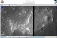
Here's a pic of a curious feature I had poinrted out once before, but with different images. A sort of Ina-like feature in Mare Tranquillitatis. There are more of these in Hyginus. How many more will turn up, I wonder?
Phil
-------------------- ... because the Solar System ain't gonna map itself.
Also to be found posting similar content on https://mastodon.social/@PhilStooke Maps for download (free PD: https://upload.wikimedia.org/wikipedia/comm...Cartography.pdf NOTE: everything created by me which I post on UMSF is considered to be in the public domain (NOT CC, public domain) |
|
|
|
|
|
 cassioli Exploring LROC NAC images Sep 18 2010, 01:22 PM
 Phil Stooke The site tells you the lat and long of the top and... Sep 18 2010, 01:33 PM
 cassioli QUOTE (Phil Stooke @ Sep 18 2010, 01:33 P... Sep 18 2010, 01:37 PM tedstryk QUOTE (cassioli @ Sep 18 2010, 01:37 PM) ... Sep 18 2010, 06:12 PM cassioli QUOTE (tedstryk @ Sep 18 2010, 06:12 PM) ... Sep 18 2010, 06:30 PM tedstryk QUOTE (cassioli @ Sep 18 2010, 06:30 PM) ... Sep 18 2010, 06:34 PM Juramike Something's not quite right here.... Sep 18 2010, 10:09 PM Juramike Here's part of the problem. The base maps are... Sep 18 2010, 11:10 PM elakdawalla This used to be a serious problem for Mars too; it... Sep 18 2010, 11:20 PM Juramike Are the NAC images flipped? (left-right reflected)... Sep 18 2010, 11:33 PM ugordan QUOTE (Juramike @ Sep 19 2010, 01:33 AM) ... Sep 19 2010, 12:39 AM Juramike I'm getting an E-W mirroring as well that I ca... Sep 19 2010, 12:59 AM elakdawalla See http://www.planetary.org/blog/article/00002422... Sep 19 2010, 02:56 AM Juramike Thanks! Sep 19 2010, 04:07 AM cassioli What I can't understand is how people is able ... Sep 19 2010, 12:23 PM Phil Stooke Cassioli, it does not work that way. The coordina... Sep 19 2010, 01:35 PM Juramike (Crosslink to a more detailed explanation of flipp... Sep 20 2010, 11:44 PM Phil Stooke ... and here's another one not far from that o... Jun 28 2011, 02:21 PM john_s The first of those, at least, looks to me like a k... Jun 28 2011, 03:31 PM
 |

|
Lo-Fi Version | Time is now: 26th April 2024 - 05:56 PM |
|
RULES AND GUIDELINES Please read the Forum Rules and Guidelines before posting. IMAGE COPYRIGHT |
OPINIONS AND MODERATION Opinions expressed on UnmannedSpaceflight.com are those of the individual posters and do not necessarily reflect the opinions of UnmannedSpaceflight.com or The Planetary Society. The all-volunteer UnmannedSpaceflight.com moderation team is wholly independent of The Planetary Society. The Planetary Society has no influence over decisions made by the UnmannedSpaceflight.com moderators. |
SUPPORT THE FORUM Unmannedspaceflight.com is funded by the Planetary Society. Please consider supporting our work and many other projects by donating to the Society or becoming a member. |
|