Printable Version of Topic
Click here to view this topic in its original format
Unmanned Spaceflight.com _ MSL _ Journey to Mt Sharp - Part 3: Cooperstown to Kimberley - Waypoint 3
Posted by: charborob Nov 14 2013, 07:57 PM
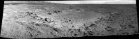
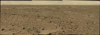
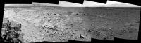
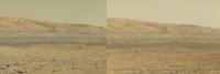
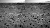
Sol 453 navcam pan:
|
|
We're moving again!

(Mods: I suppose it's time to start a new thread?)
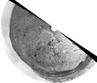
Posted by: Phil Stooke Nov 14 2013, 09:32 PM
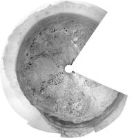
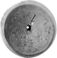
Off we go - this is a circular version of the 3/4 pan we have right now.
Phil
|
Posted by: Phil Stooke Nov 15 2013, 05:35 PM
Location after the sol 454 drive. We only have a few pics and I have not yet located this spot on the map. EDIT: Got it! - not where I expected.
Phil
|
Posted by: neo56 Nov 15 2013, 07:16 PM
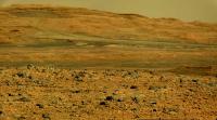
Panorama acquired with MastCam 34 on sol 453:
http://www.flickr.com/photos/105035663@N07/10873779305/
Posted by: jvandriel Nov 16 2013, 02:21 PM
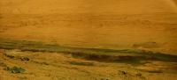
The Navcam NL B panoramic view on Sol 454.
Jan van Driel
|
|
Posted by: Phil Stooke Nov 16 2013, 07:46 PM
Here is a circular version of the panorama jvandriel posted just above, much more complete than my earlier one. Quite a rugged area. I expected we would go southwest but we turned due west. I see some thick protruding veins or fracture fill 120 m ahead in the HiRISE images (unless they are drifts, that could very well be... is it too late to retract my suggestion?), but it's perhaps more likely that the route will just turn SW past the big crater south of us. Another drive today - we'll see where that goes.
Phil
|
Posted by: PaulH51 Nov 16 2013, 11:08 PM

Phil
EDIT : Probably all AutoNav due to the duration of the drive (~195 minutes).
Posted by: James Sorenson Nov 17 2013, 04:29 AM
My version from Sol-454.
http://www.flickr.com/photos/43581439@N08/10896721205/
http://www.flickr.com/photos/43581439@N08/10897360545/
Posted by: Gerald Nov 17 2013, 08:36 PM
Sol 455 drive, seen from FLB, fisheye-corrected 125°, magnified twice:
http://imgbox.com/acp0imvH (4MB), and post-drive MAHLI: http://imgbox.com/adbmpPjh
Posted by: James Sorenson Nov 18 2013, 12:54 AM
Cool Gerald! 
I made a couple of clips of my de-fisheye processing of a video that I am producing.
http://www.youtube.com/watch?v=h2er8ESNrQE
http://www.youtube.com/watch?v=4TFKmSNbSb8
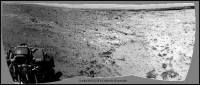
Posted by: charborob Nov 18 2013, 01:49 AM
Here's the sol 455 drive from the navcam perspective:
|
Posted by: James Sorenson Nov 18 2013, 07:21 AM
Not sure where to post this, But here is our entire Journey so far from Landing day all the way up to Sol-456
http://www.youtube.com/watch?v=VT480b8s5i8
Posted by: Gerald Nov 18 2013, 10:06 AM
Great! Supercool!
Posted by: jvandriel Nov 18 2013, 10:27 AM
The Navcam NL B panoramic view on Sol 456.
Jan van Driel
|
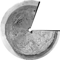
Posted by: Phil Stooke Nov 18 2013, 02:27 PM
Circular version of the above. I got the impression from a recent article - but can't recall which one - that we might bypass Waypoint 3 and move straight to Waypoint 4 (which looks fascinating and very different from this area). Time will tell.
Phil
|
Posted by: Greenish Nov 18 2013, 05:04 PM
James, that video is amazing, really impressive work. Somehow you managed to make the quality high enough and the motion smooth enough so that it really flows. Music choice works too!
Posted by: Phil Stooke Nov 18 2013, 05:15 PM
I second that emotion!
Phil
Posted by: Ant103 Nov 19 2013, 10:20 AM
Sol 456 Navcam pan
http://www.db-prods.net/marsroversimages/Curiosity/2013/Sol456_pano.jpg
Posted by: James Sorenson Nov 19 2013, 10:36 AM
Awesome Damia!
Here is the Rear Hazcam view video from Landing all the way to Sol-456. Not as many images as the front Hazard camera of coarse, but my best attempt anyway.
http://www.youtube.com/watch?v=5N-oxoQAmm4
Posted by: jvandriel Nov 19 2013, 12:04 PM
The Mastcam L view on Sol 456.
Jan van Driel
|
|
Posted by: pospa Nov 19 2013, 12:09 PM
Ken http://astrogeology.usgs.gov/news/astrogeology/sol-458-update-on-curiosity-from-usgs-scientist-ken-herkenhoff-murray-buttes some issue with wheel stall and electrical problem during Sol 455.
Posted by: jvandriel Nov 19 2013, 12:43 PM
The Mast cam L view on Sol 455.
Jan van Driel

|
Posted by: Greenish Nov 19 2013, 03:24 PM
I wonder if that has anything to do with the funny route, or if that was planned. Per the http://curiosityrover.com/tracking/drivetrack.php?drivenum=115* and Midnight Planets maps, the rover turned around and looped back more than a few meters, and is facing SE instead of SW as usual at the end of the drive. Per the http://curiositymsl.com/tracking/speedplot.php?drivenum=115, it looks like there were some steep slopes and higher speeds (including one spike) at first, then the second part of the drive was slower, and you can see where it retraces the elevation curve.
I try not to read too much into this preliminary telemetry data, but it's fun to try to figure out.
* I know the underlying terrain is getting out of sync with the map, for reasons Joe has explained elsewhere, but I am looking at the shape of the path, not the features underneath it.
Posted by: Greenish Nov 19 2013, 04:33 PM
Here's a navcam stitch looking ENE, from about halfway through the loopback I mentioned in the previous post.
|
Posted by: Astro0 Nov 21 2013, 01:48 AM
Another view from Sol455.

|
Posted by: fredk Nov 21 2013, 03:08 AM
http://mars.jpl.nasa.gov/msl/news/whatsnew/index.cfm?FuseAction=ShowNews&NewsID=1559
Posted by: CosmicRocker Nov 23 2013, 07:59 PM
That update on the electrical problem has me a little confused. Maybe an engineer will add some clarifying comments.
If a device has a 32 volt bus, shouldn't the deltaV between the bus and the chassis be 32 volts in the absence of any soft shorts? The update mentions soft shorts that dropped the deltaV from 16v to 11v to 4v, but was there an earlier event that dropped the voltage from 32v to 16v? Or, is there something else I am missing that causes the deltaV between a 32v bus and a chassis to be only 16 volts?
Also, is it correct to suspect that with only a 4 volt margin remaining after 5 volt and 7 volt soft shorts, it is unlikely the electrical system can survive another, similar soft short?
Posted by: mcaplinger Nov 23 2013, 10:41 PM
The MSL bus is set up so the chassis ground is nominally halfway between the voltages of the battery and RTG terminals.
Posted by: Phil Stooke Nov 24 2013, 02:52 AM
At last! Sol 462 - some new images are on the ground.
Phil
Posted by: djellison Nov 24 2013, 03:32 AM
Read up on 'Floating Bus'
Posted by: James Sorenson Nov 24 2013, 04:41 AM
Kind of sound's like the grounding issue that happened on Spirit.
http://marsrover.nasa.gov/spotlight/20091217a.html
Is it simular? And is the Rover wheel stall issue caused by the problem?
Posted by: mcaplinger Nov 24 2013, 04:46 AM
Technically chassis ground is referenced to the actual surface (more or less, though if you were to drive a metal rod into the surface of Mars and measure the impedence to chassis ground I'm not sure what you'd get), so it's not really floating. It's more that the low side of the battery is intentionally not at the same voltage as chassis ground.
Appendix A of https://standards.nasa.gov/documents/detail/3314876 shows the Cassini balanced bus, which is similar.

|
Posted by: bobik Nov 24 2013, 07:11 AM

|


Posted by: mcaplinger Nov 24 2013, 09:02 PM
The Spirit description was less than crystalline to me, but I think the wheel problem was more a cause than a symptom of that bus imbalance (if that's what it really was.)
In all honesty, though I'm probably supposed to understand this, I'm not certain what the advantages of a balanced bus are. I think it just gives increased visibility into current paths. I do know that the low side of the bus could be completely shorted to chassis and our instruments would work just fine -- in fact, that's how we usually operate them on the bench.
Posted by: Phil Stooke Nov 25 2013, 02:45 AM
A wee bird tells me that, though we see very few images, the arm was busy over the weekend and there will be more drives very soon.
Phil
Posted by: blueaeshna Nov 25 2013, 10:08 AM
There are a couple of Sol462 hazcam images down, looking hopeful!
Posted by: Phil Stooke Nov 25 2013, 02:43 PM
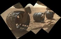
Wow - look at those wheels!
http://www.midnightplanets.com/web/MSL/image/00463/0463MH0261000000E1_DXXX.html
(no, not because they are dinged up a bit - because they look great!)
- and then look beyond them at the mountains. Even more wow - I don't know if they have ever looked so clear.
Phil
Posted by: RoverDriver Nov 25 2013, 04:59 PM
http://marsrover.nasa.gov/spotlight/20091217a.html
Is it simular? And is the Rover wheel stall issue caused by the problem?
No, the RF drive actuator for Spirit has nothing to do with floating bus or the steering actuator stall. The best explanation that came out was that the actuator stopped working due to a thin layer on the motor commutator that prevented current from flowing through the rotor's windings.
Paolo
Posted by: jvandriel Nov 25 2013, 07:34 PM
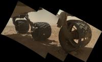
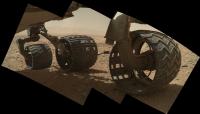
MAHLI panorama of the wheels on Sol 463.
Jan van Driel
|
Posted by: blueaeshna Nov 25 2013, 09:08 PM
Latest news on the fault http://www.jpl.nasa.gov/news/news.php?release=2013-340
Posted by: Ant103 Nov 26 2013, 12:17 PM
My take on the mosaics taken on Sol 463. Separate parts, because the centers of the mosaics is not the same.
http://www.db-prods.net/marsroversimages/Curiosity/2013/Sol463_MAHLI_1.jpg
http://www.db-prods.net/marsroversimages/Curiosity/2013/Sol463_MAHLI_2.jpg
Posted by: jvandriel Nov 26 2013, 03:18 PM
The Mastcam L view on Sol 463.
Jan van Driel
|
Posted by: charborob Nov 27 2013, 04:02 AM
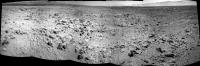
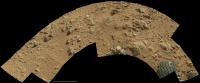
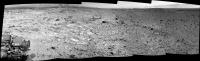
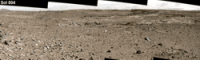
Sol 465 partial navcam pan:
|
Posted by: Astro0 Nov 27 2013, 07:29 AM
Just concentrating on the crater rim.
|
|
Posted by: Ant103 Nov 27 2013, 08:26 AM
Yes Very good visibility this sol
My take on this panorama :
http://www.db-prods.net/marsroversimages/Curiosity/2013/Sol465_pano.jpg
And Sol 463 Mastcam34 pano :
http://www.db-prods.net/marsroversimages/Curiosity/2013/Sol463_Mastcam34.jpg
Posted by: Phil Stooke Nov 27 2013, 02:22 PM
It's great to have these nice panoramas again after a bit of a break. This is Ant103's navcam pan in circular form. EDIT - OK, I updated mine too... it's hard to keep up with you! (EDIT - replaced for a second time)
Phil
|
Posted by: Ant103 Nov 27 2013, 05:22 PM
Thanks Phil ^^
In my previous post, I've updated this panorama with the last frames 
Posted by: Phil Stooke Nov 27 2013, 06:01 PM
And another product derived from Ant103... this time the Mastcam34 panorama. I subjected the horizon section to a bit of a vertical stretch (moderate, for me) to separate out the various ridges. Here they are with locations identified on a map of the landing ellipse. The black dot is Curiosity's location.
Phil
|
Posted by: ngunn Nov 27 2013, 06:47 PM
Nice one Phil. I was wondering what those low hills were.
Posted by: Ant103 Nov 28 2013, 05:51 PM
Sorry Phil, but I think that you will have to update for a third time your polar projection
http://www.db-prods.net/marsroversimages/Curiosity/2013/Sol465_pano.jpg
Posted by: Phil Stooke Nov 29 2013, 02:31 AM
OK... gasp... I can just about keep up - not as young as I used to be - gasp. I replaced the previous image with the new one rather than posting again.
Phil
Posted by: Gerald Nov 29 2013, 10:54 PM
Sol 465 MAHLI, rotated 150 degrees, white balanced and stretched by some lower region of the sky:
http://imgur.com/XvkhYKG
and MARDI of the same Sol:
http://imgur.com/pGtzrAS
Posted by: James Sorenson Nov 30 2013, 10:18 AM
The Right Mastcam Pan for Sol-467
|
|
http://www.gigapan.com/gigapans/145576
Posted by: Gerald Nov 30 2013, 01:39 PM
What a landscape!
Just one of the Sol 367 MR images, white-balanced using lower sky, 4-fold enhanced:
http://imgur.com/PCRCL3Q
Posted by: Phil Stooke Nov 30 2013, 02:26 PM
Yes, it's amazing - and just wait a bit and we'll be right in there among those hills. Fantastic place!
Phil
Posted by: neo56 Nov 30 2013, 03:50 PM
My take on the MC100 panorama taken on sol 467:
http://www.flickr.com/photos/105035663@N07/11326817666/
In false colors, to highlight colors differences between rocks:
http://www.flickr.com/photos/105035663@N07/11326860106/
I removed the "black dots" which appear on every MC100 pictures (dust on the CCD ?) with the GIMP cloning tool.
I'm not totally satisfied with the blending process, seams are too pronounced.
I'm using PTGui to make my pans. I select "PTGui" for the option "Blend using...". I tried using "Enblend plugin" but the result is worse. I also tried the option "Perform automatic exposure and color adjustment" when aligning images. Seams are less pronounced but there is a gradient of luminosity from the left to the right part of the panorama.
James, your result is much more better. Could you tell me what software do you use to make your pans ?
UPDATE: after flatfielding MC100 photos using sol 36 pictures of the sky, the result is much better and seams are no more visible (thank you James for your help! )
Posted by: James Sorenson Nov 30 2013, 05:54 PM
PTGui, Autopano Pro Giga, and Photoshop. PM me if you want further help, I'd be happy to.
Posted by: wildespace Dec 1 2013, 11:05 AM
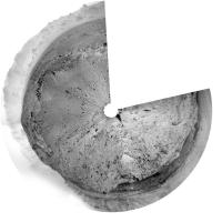
Sol 469, MAHLI looking at its wheels again. http://mars.nasa.gov/msl/multimedia/raw/?s=469&camera=MAHLI
One of the wheels is balanced on a rock!
|
Posted by: Astro0 Dec 2 2013, 06:34 AM
Sol468 - Area around the wheels.
|
Posted by: charborob Dec 2 2013, 01:21 PM
Sol 470 partial navcam pan:
|
|
Edit: added recently received images.
Posted by: Phil Stooke Dec 2 2013, 02:38 PM
Charborob's partial pan in circular format. Three rocks nearby on the west side are visible in HiRISE to give a good location for the map.
Phil
|
Posted by: charborob Dec 2 2013, 08:19 PM
I edited my previous navcam pan for sol 470, as some new images have been received.
Maybe I should curb my panorama-making enthousiasm and wait until all images are available.
Posted by: EdTruthan Dec 2 2013, 10:31 PM
Sol 470 - Nine Frame Navcam Anaglyph...
http://www.edtruthan.com/mars/Sol470-Navcam-9-Frame-Panorama-Anaglyph.jpg
Personal Note: An unusually brisk period of business and family related activitities has kept me from posting much of anything the last few months but I've been keeping abreast of things as time allows and enjoying the posts and graphics from everyone here at the forum. As usual, excellent work from all! Finally had a few moments to knock out an anaglyph from yestersol's position. Looks like some rough country ahead...
Posted by: jvandriel Dec 4 2013, 11:27 AM
The wheels seen on Sol 472 by the MAHLI cam.
Jan van Driel
|
|
Posted by: Phil Stooke Dec 4 2013, 02:29 PM
Very nice pictures.
This is the sol 472 partial pan (roughly thrown together) in circular form to help locate the rover.
Phil

|
Posted by: jvandriel Dec 4 2013, 04:02 PM
The partial Sol 472 pancam NL B view.
Jan van Driel
|
Posted by: Phil Stooke Dec 4 2013, 08:02 PM
As of sol 472 we are on the verge of entering a new map quadrangle. The science team divided the landing region into map areas called quadrangles for geological mapping before landing. Each one gets a name and a scheme for feature names. The first one, the landing area, was Yellowknife Quadrangle, with names taken from northern Canadian geology. The second, Mawson, took names from Antarctic geology. Cooperstown (Waypoint 2) was in a third quadrangle whose names come from (as far as I can tell) the NE USA/New England region, but I don't know the quadrangle name. And now we are about to cross into a new quadrangle, but the name has not been released yet.
If anyone can fill in a little more information, please do!
Phil
Posted by: James Sorenson Dec 5 2013, 09:51 AM
A few images left to go, but here is the Sol-468 M34 360 Pan.
http://www.gigapan.com/gigapans/145852
|
|
Posted by: Astro0 Dec 6 2013, 06:12 AM
Gale wall crop from Sol468 pan
|
|
This has been reduced in size from 19000px to 13500px wide.
Posted by: James Sorenson Dec 6 2013, 08:06 AM
http://makeagif.com/i/3PRsJK
http://makeagif.com/i/P4xEyf
http://www.flickr.com/photos/43581439@N08/11233243834/
EDIT:
http://www.flickr.com/photos/43581439@N08/11233632616/
Posted by: jvandriel Dec 6 2013, 09:36 AM
The Navcam NL B view on Sol 474.
Jan van Driel
|
Posted by: Gerald Dec 6 2013, 10:41 AM
Sol 474 RLB 5-image wheel-watching:
http://imgur.com/zNsa6O9
Posted by: PaulH51 Dec 6 2013, 11:51 AM
Looks like the suspension is getting a good workout
Posted by: Phil Stooke Dec 6 2013, 02:40 PM
|
Just a short drive to the west, and given the many images of the wheels I might speculate that it was mainly for wheel mapping.
Phil
Posted by: EdTruthan Dec 7 2013, 09:58 PM
Sol 468 - MC34 - 360 Panorama is now complete...
Click thumb for a Quarter Sized Version (at 7500 x 2194 pixels - 3.49MB):
http://www.edtruthan.com/mars/Sol468-MC34-360-Degree-Panorama-7500x2194px.jpg
...The Full Resolution version came in at a bit over 32,000 pixels in width. Here's a near Full Resolution at a whopping 29,999 x 8,774 pixels (had to reduced the width slightly for some Photoshop handling)....
>>>> 35.51MB Zip File: http://www.edtruthan.com/mars/Sol468-MC34-360-Degree-Panorama-29999x8774px.zip
Posted by: EdTruthan Dec 8 2013, 01:16 AM
Sol 474 - 360 Degree Navcam Anaglyph (bottom cropped)...
http://www.edtruthan.com/mars/Sol474-Navcam-360-Degree-Anaglyph.jpg
Can't see that large crater just a few meters off to the SE yet due to what appears to be it's slightly elevated western rim, but it'd sure be nice to mosey over there and get a view of it. Especially that picturesque dune field on it's floor...
2-D View - (NLB - full frame)...
http://www.edtruthan.com/mars/Sol474-Navcam-360-Degree-Panorama.jpg
Posted by: jvandriel Dec 8 2013, 08:36 PM
The wheels again on Sol 476
Jan van Driel
|
|
Posted by: jvandriel Dec 8 2013, 09:17 PM
The Mastcam L view on Sol 474
Jan van Driel
|
|
Posted by: Gerald Dec 9 2013, 01:17 PM
After quite a while, a http://mars.jpl.nasa.gov/msl/news/whatsnew/index.cfm?FuseAction=ShowNews&NewsID=1564 today at AGU at 9 a.m. PST.
http://astrogeology.usgs.gov/news/astrogeology/sol-476477-update-on-curiosity-from-usgs-scientist-ken-herkenhoff-good-time-for-an-upgrade
X-Eyed view of where we'll probably stay this week:
http://imgur.com/n6uNkXB
after http://curiosityrover.com/tracking/drivetrack.php?drivenum=120.
Posted by: Ant103 Dec 9 2013, 03:21 PM
Just to say : I have moved from an place, to an other, and while the Internet is coming back at home, I will not able to do a proper work. It will just be a matter of Sols. I mean
Days ^^
Posted by: fredk Dec 9 2013, 03:36 PM
And http://www.nasa.gov/news/media/newsaudio/index.html
Posted by: MarkG Dec 9 2013, 06:00 PM
After the first briefing, I'm left with one question that this group could anwer...
Any young impact craters on proposed path of Curiosity?
Posted by: Phil Stooke Dec 9 2013, 07:07 PM
The target area KMS_9 mentioned in the announcement is the same as Waypoint 4, looking back at the map showing the waypoints. I don't know what the KMS refers to.
And as far as I can see there are no really fresh craters along the way.
Phil
Posted by: peter59 Dec 10 2013, 10:24 AM
I didn't notice earlier this large crater on the inner slope of Gale crater.
http://mars.jpl.nasa.gov/msl-raw-images/msss/00477/mcam/0477ML1893001000E1_DXXX.jpg
Posted by: jvandriel Dec 10 2013, 03:22 PM
The Mastcam L view on Sol 477.
Jan van Driel
|
|
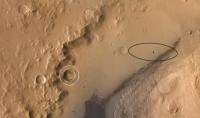
Posted by: fredk Dec 10 2013, 04:24 PM
http://mars.jpl.nasa.gov/msl-raw-images/msss/00477/mcam/0477ML1893001000E1_DXXX.jpg
Good catch. I think we're seeing this crater, circled in white:
|
Posted by: mhoward Dec 10 2013, 04:47 PM
Yes, the crater in question is about 10º south of west, and everything seems to line up with the map. Nice indeed. What a view!
|
Posted by: jvandriel Dec 10 2013, 07:56 PM
Nice view.
Just part of the Mastcam R panorama on Sol 467.
Jan van Driel
|
|
Posted by: craigmcg Dec 10 2013, 11:41 PM
Stunning. Are we there yet?
Posted by: Ant103 Dec 11 2013, 02:22 PM
Here is my version of the Sol 468 Mastcam34 full color pan It's a pretty heavy pan ^^
http://www.db-prods.net/marsroversimages/curiosity-2013.html#113
Posted by: dilo Dec 11 2013, 04:05 PM
Marvellous, Damia! I used this and another clear view made by you (Sol437) to make a long baseline stereogram near "Entry point":
|
Posted by: serpens Dec 11 2013, 09:44 PM
The layering of the dark beds looks to be pretty much planar and therefore could / should have extended well beyond current bounds. There has obviously been a lot of Aeolian erosion since the massive depositional sequence. The upper mound seems to fit Kite's model but not so much the dark layers. Has anyone seen any "official" speculation on the depth of material removed from Opportunities (oops edit Curiosity's)current position? The Yellowknife Bay scarp retreat model reflects some 3 metres over 80 Myr, but that is in an essentially benign environment.
Posted by: elakdawalla Dec 11 2013, 09:54 PM
It's hard to say. The minerals can't ever have been heated to high temperature: "The presence of smectite, magnetite, and akaganeite suggests that the mudstone has not experienced burial heating above ~200°C." (Farley et al). But the geothermal gradient at Gale is quite low (15 degrees per km) so they could've been buried by several kilometers and not experienced such a high temperature. I recall someone saying at AGU that they were likely buried at 10s to 100s of meters but unfortunately I can't remember who said that or how they supported that statement.
The scarp retreat numbers are not 3 m per 80 my. Scarp retreat is a horizontal process, not a vertical one, and the number they reported is 1 meter of scarp retreat per million years. The surface of the Sheepbed unit is also deflating vertically but that's happening substantially more slowly.
Posted by: serpens Dec 12 2013, 03:20 AM
Thanks Emily. I was actually referring to vertical deflation as a function of scarp retreat. Analysis suggests the sample was close to the surface at around 80 Myr ago but prior to that (over 80 Myr ago) it had to be protected by at least 3 metres thickness of material. The lower reaches of Mount Sharp seem to imply at least hundreds of metres of deflation. It took years to get a handle on Meridiani - Gale may take longer.
Posted by: jvandriel Dec 12 2013, 09:07 AM
The Mastcam R panoramic view on Sol 475.
Jan van Driel
|
Posted by: jvandriel Dec 12 2013, 09:39 AM
and the other one from Sol 475.
Jan van Driel
|
Posted by: Gerald Dec 12 2013, 11:35 AM
A try of a transscript of John Grotzinger in the http://mars.nasa.gov/msl/news/whatsnew/index.cfm?FuseAction=ShowNews&NewsID=1564, 05:38-06:21:
The geological context of all these rocks: there is obviously material below these outcrops, and we know there was rock above these outcrops, because we see fractures exposed in the rocks, which means the fractures must've been developed at some depth of burial.
So by a fairly simple geological interpolation we can assume that these rocks probably were once 10s of meters to may be even 100s of meters thick, and that they therefore represent on the order of millions to even tens of millions of years of time, which is quite a long window of habitability.
Posted by: pospa Dec 12 2013, 01:09 PM
Any news about ongoing rover http://astrogeology.usgs.gov/news/astrogeology/sol-476477-update-on-curiosity-from-usgs-scientist-ken-herkenhoff-good-time-for-an-upgrade ?
Posted by: Phil Stooke Dec 12 2013, 09:09 PM
Installed, tested, nearly ready to use. Should be active again pretty soon (a little bird tells me).
Phil
Posted by: Olivier Dec 12 2013, 10:10 PM
Was the power glitch from Nov 17th related to the software upgrade (and glitch) from a couple of days earlier, or it only (unfortunately!) happened one after the other?
Olivier
Posted by: vikingmars Dec 12 2013, 11:05 PM
Olivier
Welcome Olivier to the UMSF Forum ! (another Olivier... great !)
Posted by: Gerald Dec 12 2013, 11:48 PM
Olivier
From the infos published so far, I can't see an immediate connection.
The power glitch has been pinned down to be most likely RTG-related, as also has http://trs-new.jpl.nasa.gov/dspace/bitstream/2014/42773/1/12-1533_A1b.pdf
Posted by: neo56 Dec 13 2013, 03:04 PM
My take on the MC100 photos taken on sol 475:
http://www.flickr.com/photos/105035663@N07/11353345515/ http://www.flickr.com/photos/105035663@N07/11353509875/
Posted by: neo56 Dec 13 2013, 04:01 PM
RMI pictures have been taken on sol 475, focusing on the base of Mount Sharp. Here are these RMI mosaics along with a context:
http://www.flickr.com/photos/105035663@N07/11354840576/
Posted by: dilo Dec 16 2013, 03:33 PM
Do someone knows why we do not have new images nor updates in last 6 days? Can be related to programmed software update? 
Posted by: Gerald Dec 16 2013, 03:42 PM
I'd say, you've given the answer, plus AGU last week and week end.
Posted by: elakdawalla Dec 16 2013, 03:47 PM
Yep. Bobak Ferdowsi https://twitter.com/tweetsoutloud/status/411942161723060224 that it was the last day of the FSW install. I expect we'll see new stuff soon.
Posted by: EdTruthan Dec 16 2013, 06:46 PM
Long Baseline MC34 Anaglyph...
Taking a que from http://www.unmannedspaceflight.com/index.php?s=&showtopic=7747&view=findpost&p=205319, here's an all MC34 anaglyph view comprised of the Sol 437 and Sol 468 panos. Baseline is about 275 meters. The focal point is on or about the base of the foothills but with such a wide baseline, pulling in the the flats and mesa's in the closer dune field foreground area requires a bit of eye adjustment but it's easily doable without a great deal of eye strain if one focuses on the foothills first and slowly moves their focus closer.
http://www.edtruthan.com/mars/Sol437-and-468-MC-34-Mt-Sharp-Foothills-Long-Baseline-Anaglyph.jpg
Posted by: CosmicRocker Dec 17 2013, 05:51 AM
I can do that, but it did strain my eyes a bit. This is shaping up to be every bit of the expedition of discovery that I thought it would be. I look forward to every step.
Thanks for that, Ed.
Posted by: Phil Stooke Dec 17 2013, 04:36 PM
Pictures!
Phil
http://www.midnightplanets.com/web/MSL/sol/00485.html
Posted by: dilo Dec 17 2013, 05:24 PM
Posted by: Gerald Dec 17 2013, 06:37 PM
... and APXS, visible in Sol 485 Front Hazcam stereo, fisheye-corrected 125°:
http://imgur.com/UnCE0n1
Posted by: Greenish Dec 17 2013, 07:17 PM
Here's a heavily color-stretched mosaic of the area of investigation, from Sol 477 MR.

|
Posted by: Greenish Dec 17 2013, 07:18 PM
And one in the original colors.

|
Posted by: Gerald Dec 17 2013, 08:31 PM
http://astrogeology.usgs.gov/news/astrogeology/sol-485-update-on-curiosity-from-usgs-scientist-ken-herkenhoff-upgrade-complete
http://mars.jpl.nasa.gov/msl-raw-images/msss/00485/mhli/0485MH0153000001R0_DXXX.jpg.
I'm not quite sure, but this looks a little like brushed to me.
Posted by: Phil Stooke Dec 17 2013, 08:33 PM
Yes, it looks like the DRT was used.
Phil
Posted by: elakdawalla Dec 17 2013, 11:08 PM
I was checking out the Curiosity data on the Analyst's notebook and found a comment in the uplink report in one sol (I didn't note which one it was, sadly, but I'm fairly sure it was while they were at Cumberland) to the effect that they weren't allowed to use the DRT for some reason. I looked forward and back in time to see what that was about, but didn't see any further information. Does anybody know anything about this? When was the last time we saw the DRT used?
(I realize that the last question especially can be answered for myself by patiently looking back through the daily images but I'm swamped and am hoping someone here will find that an enjoyable activity or will actually have that info at their fingertips.)
Posted by: Phil Stooke Dec 18 2013, 03:39 AM
DRT was last used at Cumberland just before they departed. Comments like that are common in the Notebook, for one thing or another, ChemCam or REMS etc. - some temporary fault which is usually fixed soon.
Phil
Posted by: elakdawalla Dec 18 2013, 05:35 AM
I clearly need to spend a few days just reading those reports. There's a wealth of information in them.
Posted by: elakdawalla Dec 18 2013, 04:34 PM
I am pretty sure Curiosity has just spat out the leftovers from the Cumberland drill hole.
http://www.midnightplanets.com/web/MSL/image/00486/0486MH0244001003E1_DXXX.html
Posted by: fredk Dec 18 2013, 05:39 PM
Context:
http://mars.jpl.nasa.gov/msl-raw-images/proj/msl/redops/ods/surface/sol/00486/opgs/edr/ncam/NRB_440636804EDR_S0240366NCAM00469M_.JPG
Posted by: EdTruthan Dec 18 2013, 09:29 PM
Sol 485 - 3-frame Navcam foreground anaglyph...
http://www.edtruthan.com/mars/Sol485-Navcam-3-Frame-Foreground-Anaglyph.jpg
Posted by: PaulH51 Dec 18 2013, 10:03 PM
It appears to be. Dumped after >200 sols. Note : Ken Herkenhoff report of 18 December http://astrogeology.usgs.gov/news/astrogeology/sol-487-update-on-curiosity-from-usgs-scientist-ken-herkenhoff-dump-pile
Posted by: Actionman Dec 19 2013, 12:46 AM
The pile looks like portland.
Posted by: MahFL Dec 19 2013, 01:49 PM
From the Notebook :
"Strategic Guidance: Drive...Drive...Drive!!!"
Now that sounds good.
Posted by: Gerald Dec 19 2013, 10:25 PM
Sol 487 MAHLI anaglyph of Cumberland dump:
http://imgur.com/a2OLliZ
Reduced x-eye version:
http://imgur.com/k83dmXK
Posted by: neo56 Dec 20 2013, 08:52 AM
MC100 photos taken on sol 486. Nice layering !
http://www.flickr.com/photos/105035663@N07/11461608193/
http://www.flickr.com/photos/105035663@N07/11461620563/
Posted by: jvandriel Dec 20 2013, 10:02 AM
Another view from the MAST L cam taken on Sol 486.
Jan van Driel
|
|
Posted by: Ant103 Dec 20 2013, 11:19 AM
Sorry, but I couldn't resist to "convert" the Sol 468 Mastcam34 pan into a big Postcard of my own
Enjoy
http://www.db-prods.net/blog/2013/12/20/journey-to-mount-sharp-a-sol-468-postcard/
Posted by: Ant103 Dec 21 2013, 02:16 PM
Checkin' up the wheels on Sol 488.
http://www.db-prods.net/marsroversimages/Curiosity/2013/Sol488_MAHLI.jpg
Posted by: Airbag Dec 21 2013, 07:10 PM
The view ahead for Sol 488; Mastcam-34, slightly contract stretched. More rough, rocky terrain.

|
Airbag
Posted by: Ant103 Dec 21 2013, 08:26 PM
And with Mastcam100
http://www.db-prods.net/marsroversimages/Curiosity/2013/Sol488_Mastcam100.jpg
Posted by: Phil Stooke Dec 21 2013, 09:08 PM
Beautiful! Looks like we will be moving soon.
Phil
Posted by: Phil Stooke Dec 22 2013, 07:44 PM
A move on sol 490, but only a little one, just a bump forwards. The rock with the dumped sample on it is now between the front wheels.
Phil
Posted by: Gerald Dec 22 2013, 08:21 PM
Sol 488 MARDI montage (enhanced):
http://imgur.com/nwkNQEY
Probably the first time we have overlapping MARDI images when driving.
Edit: The overlap can be used for x-eyed stereo http://imgur.com/ikA2lMG or anaglyph http://imgur.com/jllpfmH.
But low quality makes it a bit challenging.
Posted by: Phil Stooke Dec 23 2013, 12:56 AM
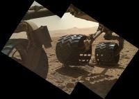
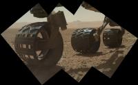
The multiple MAHLI mosaics of the wheels on sol 490 must be intended to allow full mapping of the wheel surfaces - a small turn between each set of pictures.
Phil
Posted by: jvandriel Dec 23 2013, 08:38 PM
The Mastcam L view on Sol 490.
Jan van Driel
|
|
Posted by: Bubbinski Dec 27 2013, 12:12 PM
Looks like the rover got on the road again on sol 494. Curiosity's now parked in front of what looks like a sand pit or small crater.
(to the strains of Willie Nelson's "On the Road Again")
Posted by: Phil Stooke Dec 27 2013, 02:46 PM
Yes, it's not a very long drive but at least we are moving again. I can't update our map until after New Year.
Phil
Posted by: jvandriel Dec 28 2013, 12:53 PM
The Mastcam R view on Sol 494.
Jan van Driel

|
Posted by: jvandriel Dec 28 2013, 03:55 PM
The 360 degree Navcam L panoramic view on Sol 494.
Jan van Driel
|
|
Posted by: jvandriel Dec 28 2013, 04:22 PM
Animation of one of the wheels on Sol 494.
Jan van Driel

|
Posted by: EdTruthan Dec 29 2013, 02:53 AM
Sol 494 - Navcam 360 Degree Anaglyph...
http://www.edtruthan.com/mars/Sol494-Navcam-360-Degree-Panorama-Anaglyph.jpg
...and another 2-D NLB view...
http://www.edtruthan.com/mars/Sol494-Navcam-360-Degree-Panorama.jpg
Posted by: Phil Stooke Dec 29 2013, 04:28 AM
And a circular view from jvandriel's pan. Map update in a few days.
Phil

|
Posted by: neo56 Dec 29 2013, 05:14 PM
Panorama taken on sol 494 with MastCam 34 mm (one photo is still missing):
http://www.flickr.com/photos/105035663@N07/11626686535/ http://www.flickr.com/photos/105035663@N07/11628067616/
http://www.flickr.com/photos/105035663@N07/11643418756/
Also available here: http://www.gigapan.com/gigapans/147288
Posted by: Bubbinski Dec 31 2013, 02:29 AM
Haven't seen raw images for a few days. Sol 494 was the last time they came down according to the MSL web site. What's going on?
Posted by: Gerald Dec 31 2013, 12:13 PM
Holidays / weekend.
Posted by: RoverDriver Dec 31 2013, 04:59 PM
What is a "holiday"?
Posted by: dvandorn Dec 31 2013, 05:55 PM
A holiday is one of those days when you don't have to do drab, uninteresting things and can instead do things you really want to be doing...
Come to think of it, if I did what you do, I'd wonder what a holiday is, too...
-the other Doug
Posted by: Phil Stooke Dec 31 2013, 06:19 PM
... it's one of those days when your spouse won't let you go to the office!
Phil
Posted by: RoverDriver Dec 31 2013, 06:23 PM
On a side note, on MSL we have "Solidays", a non-planning day when we transition from restricted Sols to non-restricted Sols. I wonder if this word together with "Tosol", "Yestersol" will ever make it to the Webster's Dictionary. I definitely use them more often than "selfie". ;-)
Happy 2014 'yall.
Paolo
Posted by: fredk Dec 31 2013, 07:34 PM
Shouldn't that be "holisols"?
No, wait - "holisols" are what wander the holodeck on Halloween, right?

Posted by: Explorer1 Jan 1 2014, 08:06 AM
Happy sol 500 Curiosity, and a happy new year to those of us on Earth!
Posted by: DEChengst Jan 1 2014, 05:14 PM
Let's all celebrate sol 500 by getting a Curiosity Lego model:
http://shop.lego.com/en-NL/NASA-Mars-Science-Laboratory-Curiosity-Rover-21104
Posted by: stevesliva Jan 1 2014, 06:27 PM
For whatever reason, I long pronounced Sol like soul, but then it was pointed out here it's more commonly pronounced like Sol the nickname for Solomon. Saahl. Spanish for "Salt."
Posted by: James Sorenson Jan 1 2014, 09:58 PM
My version of the Sol-494 360 degree M34 panorama.
Gigapan
http://www.gigapan.com/gigapans/147377
http://www.flickr.com/photos/43581439@N08/11683836914/
http://www.flickr.com/photos/43581439@N08/11683693863/
Posted by: wildespace Jan 2 2014, 07:08 PM
Fantastic, thank you! I'd love to see this panorama in Photosynth, or any other 360-degree "look around" site. (Although I think Photosynth only accepts panoramas assembled in Microsoft ICE.)
As a "throwback Thursday", here's my Photosynth panorama at Curiosity's landing site (images from Sols 3 and 13): http://photosynth.net/view.aspx?cid=872fae74-906a-4959-91a8-b9e4abcdec5a
Here's another one, a self-portrait from Sol 177: http://photosynth.net/view.aspx?cid=28b0896a-95fa-4f6a-9e42-b9553ab01066
Posted by: kenny Jan 3 2014, 12:39 PM
Bought one 2 days ago... quite a bit cheaper than Yutu on eBay !
Posted by: dilo Jan 3 2014, 05:51 PM
...one entire week without new images/info... I am starting to be nervous again!
Posted by: Gerald Jan 3 2014, 06:19 PM
Some impatience, yes. Nervous? Not before Wednesday next week.
Btw.: How long lasts a week-equivalent (if unique) on Mars?
Posted by: nprev Jan 3 2014, 06:26 PM
Still the holiday season, all...relax.
Posted by: djellison Jan 3 2014, 08:32 PM
You've been a member here for 8 years. You really should know better.
Posted by: elakdawalla Jan 3 2014, 08:40 PM
http://astrogeology.usgs.gov/news/astrogeology/sol-502-update-on-curiosity-from-usgs-scientist-ken-herkenhoff-back-to-full-science-operations
During the holiday break from tactical operations, I was happy to help John Grotzinger finalize his http://www.planetary.org/blogs/guest-blogs/2013/20131221-habitability-taphonomy-and-curiositys-hunt-for-organic-carbon.html. I'm expecting that MSL will continue to produce such interesting results in 2014!
Posted by: dilo Jan 3 2014, 10:23 PM
You're right, Doug, I should... clearly my Mars addiction is worsening with time, toghether with my memory!

(anyway, within few days, they will be 9 years of addiction...!)
Edit: Look http://mars.jpl.nasa.gov/msl/multimedia/raw/?s=#/?slide=502, it seems they are listening to me!
Posted by: elakdawalla Jan 5 2014, 05:29 AM
That is really nice work, Vitaliy.
What's up with the bright glints on the rightmost side of http://www.midnightplanets.com/web/MSL/image/00502/0502MR1969002000E1_DXXX.html? I wonder if it's bright underneath the dust? Or is it just a sun angle effect?
Also: What's up with the changes of plane in the laminations of http://www.midnightplanets.com/web/MSL/image/00502/0502MR1976002000E1_DXXX.html? Is it just some layers weathering and then tilting after weathering? It's doing a good impression of those plane changes being primary features.
Posted by: djellison Jan 5 2014, 05:33 AM
Are we looking at a wind polished vesicular basalt?
Posted by: neo56 Jan 5 2014, 09:57 AM
Mosaic of MastCam 100 mm photos taken on sol 502:
http://www.flickr.com/photos/105035663@N07/11771253425/
Posted by: kenny Jan 5 2014, 10:18 AM
The wind-shaped rocks we saw before, like the ventifact Spirit saw on the rim of Bonneville, have generally had a dust coating and a matt appearance.
Shiny stuff like that reminds me of, dare I say it, the iron meteorites.
Posted by: Gerald Jan 5 2014, 01:28 PM
I'd think, that trapped gas during lithification of sediments is the most likely explanation of what is investigated thus far:
http://www.sciencemag.org/cgi/rapidpdf/science.1245267v1?ijkey=9E0E/9N2h/iJw&keytype=ref&siteid=sci, p.1, second column, free access via http://gps.caltech.edu/~grotz/Publications/MSL%20Publications.html.
But for the current rock diagenetic vesicular basalt is certainly not yet ruled out, although there is no known source, where this basalt may come from. (Somewhere in the publications the Point Lake rocks have been discussed in a similar way IIRC, but I don't remember exactly where.)
I'd guess, they try to constrain it with the current investigation.
Edit: Found at least some fragment of the discussion:
(http://www.sciencemag.org/cgi/rapidpdf/science.1242777v1?ijkey=IXbEQ.1rmX4W.&keytype=ref&siteid=sci, p. 3, left column, free access, see above)
Posted by: Actionman Jan 5 2014, 01:30 PM
If this it the windward side it seems to be non-stick finish.
Posted by: john_s Jan 5 2014, 03:49 PM
That is odd, isn't it? It looks so unlike normal cross-bedding that I think the "tilting after weathering" explanation is probably the most likely one, but if so, it has been buried subsequently, at least by a thin layer of wind-blown material, and is now being exhumed again.
John
Posted by: neo56 Jan 5 2014, 04:32 PM
The wall of Gale crater imaged on sol 502 with MastCam 34 mm:
http://www.flickr.com/photos/105035663@N07/11799937453/
Contrast enhanced to highlight details on the wall:
http://www.flickr.com/photos/105035663@N07/11799707635/
Posted by: stevesliva Jan 5 2014, 06:22 PM
That last one is really nice, neo56. Fun to scroll horizontally.
For those, like me, who have been stymied by flicker recently, the "view all sizes" option is buried beneath an ellipsis. Click the "..." in the right sidebar and select "Download / all sizes."
Posted by: Ant103 Jan 5 2014, 06:41 PM
My take on this magnificent panorama
http://www.db-prods.net/marsroversimages/curiosity-2014.html#1
Hey MSL team, how about using the Mastcam100 in order to produce the same panoramic ?
Posted by: neo56 Jan 5 2014, 06:53 PM
I told myself exactly the same thing
Posted by: serpens Jan 5 2014, 10:13 PM
Could this not be the effect of localised slumping of unconsolidated sediment? This would imply a reasonably fast deposition for the thin layering that may have covered the blockier (mudstone?). Though as John notes, tilting after weathering is perhaps the most likely, or at least most comfortable explanation.
Posted by: Gerald Jan 5 2014, 10:57 PM
There are crushed rocks at the left side. So the tilt might also be impact-related.
Posted by: Phil Stooke Jan 5 2014, 11:16 PM
My take on the tilting layers? Just a chunk comprising one prominent layer and a few lesser ones below it which has fallen a few cm from the higher part of the rock and rotated as it fell.
Phil
Posted by: serpens Jan 5 2014, 11:25 PM
I would agree Phil, were it not for the inclination of the rocks to the left of the 'prominent tilted layer'. Overall there is the impression of a small syncline .
Posted by: HughFromAlice Jan 6 2014, 01:41 AM
Ant & Neo - nice work, done with a lot of care! Having two screens helps me enjoy panoramas like this. Everyone else - the hi res images are REALLY worthwhile checking out.
Hᴜɢʜ
..ツ
Posted by: Gerald Jan 6 2014, 07:52 AM
http://curiosityrover.com/tracking/drivetrack.php?drivenum=124.
Posted by: Ant103 Jan 6 2014, 11:07 AM
Thank you HughFromAlice I like hugs :3
How about with some more sky ?
http://www.db-prods.net/blog/2014/01/06/les-montagnes-du-cratere-gale-sol-502/
Posted by: pospa Jan 6 2014, 11:56 AM
Simply STUNNING, Damia! ... as always.
Posted by: Phil Stooke Jan 6 2014, 02:42 PM
Yes, beautiful indeed.
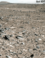
This is a semicircular view of the current location, sol 504 drive.
Phil

|
Posted by: dilo Jan 6 2014, 03:07 PM
A brutal enhancement on last Damia panorama of distant rim, in order to better see low contrast features...
|
|
And a 2.5x vertical enhancement:
|
|
Posted by: neo56 Jan 6 2014, 05:07 PM
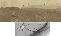
To give more perspective to the scene, here is a correspondance of several features observed on the Curiosity's panorama with a mosaic of CTX pictures from Google Mars:
http://www.flickr.com/photos/105035663@N07/11801984163/
The most distant point is point 19 at 46 km. Point 1 is at 30 km, point 10 is at 26 km and point 21 is at 17 km.
Posted by: Ant103 Jan 7 2014, 12:47 AM
Very good jobs
Sol 504 Navcam pan. Love the lighting.
http://www.db-prods.net/marsroversimages/Curiosity/2014/Sol504_pano.jpg
EDIT : UPDATED
Posted by: Thomas Sturm Jan 7 2014, 05:30 AM
Are there already any long term plans for the rover beyond Mt Sharp? That S-shaped creek bed on the crater wall in the latest panorama would be my favorite destination once the rover makes it down from the mountain... [sorry if this is off-topic!]
Posted by: Explorer1 Jan 7 2014, 06:26 AM
No more than there are long-term plans for Oppy after Endeavour; the science is just so rich at the main destination. Anything beyond will be planned when its completely exhausted (far beyond the primary mission, I'm guessing).
Posted by: Phil Stooke Jan 7 2014, 01:41 PM
This has been considered in the later landing site workshops, with interesting targets in the mountain highlighted. Also, nice though that valley to the north looks, there are much better targets west and southwest of Mt Sharp if they decide to return to the plains. In particular there is a much bigger valley on the southwest wall of the crater which produced a big delta or fan.
Phil
Posted by: jvandriel Jan 7 2014, 03:44 PM
Sol 504.
The Mastcam L panoramic view.
Jan van Driel
|
|
Posted by: Zelenyikot Jan 7 2014, 08:29 PM
My panorama of the all crater rim at 494 and 502 sols.
http://ic.pics.livejournal.com/zelenyikot/65139567/62761/62761_original.jpg
http://img-fotki.yandex.ru/get/9808/5155288.0/0_b7711_b857cb03_orig

|
Posted by: neo56 Jan 7 2014, 09:18 PM
Nice job Zelenyikot! And very beautiful sky! I can't get tired of looking for new details on the crater wall...
Posted by: fredk Jan 8 2014, 05:26 AM
The scenery is starting to get more interesting... Have your cameras ready...

|

|
Posted by: Astro0 Jan 8 2014, 10:46 AM
Intrigued by this ChemCam image taken on Sol 505.
Light-coloured vertical line-like features.
Some slope streaks too

|
Posted by: tdemko Jan 8 2014, 01:56 PM
This is a regional unit which also is very intriguing to me. It looks to me like a significant weathering horizon or paleosol lower in the stratigraphic succession. It is darker (reddish brown), and has prominent filled fractures which look to me like vertic shrink-swell or deep desiccation cracks. I think it may be the preserved landscape surface over which the fluvial-lacustrine sediments that Curiosity has been studying over the first part of her journey were deposited. The identification of smectitic clays in the overlying section is exciting because they are an important contributor to the formation of vertic features in terrestrial soils, along with seasonal or periodic fluctuations in soil moisture or water table. I've mentioned this unit to several of the Science Team members who I've encountered at meetings and through my job, and they haven't objected too strenuously to my interpretations!
--Tim
Posted by: jvandriel Jan 8 2014, 03:57 PM
Here is the complete Navcam L view taken on Sol 504.
Jan van Driel
|
|
Posted by: Phil Stooke Jan 8 2014, 07:37 PM
Jan's new panorama for sol 504 in circular form.
Phil

|
Posted by: atomoid Jan 8 2014, 09:09 PM
Crosseye of detail from part of http://www.midnightplanets.com/web/MSL/image/00506/0506MH0190001000C0_DXXX.html on SOL 507 506

|
Posted by: Zelenyikot Jan 8 2014, 09:34 PM
ChemCam + MastCam panorama. Sol 505.
|
|
|
|
Posted by: serpens Jan 8 2014, 11:31 PM
Light-coloured vertical line-like features....
Dewatering pipes?
Posted by: walfy Jan 8 2014, 11:40 PM
The rock from sol 507 for the glasses:

|
Posted by: atomoid Jan 9 2014, 12:24 AM
the http://curiosityrover.com/imgpoint.php?name=CR0_442329347EDR_F0250154CCAM04503M_ context http://curiosityrover.com/imgpoint.php?name=0505MR1985000000E1_DXXX shows them almost visible in color at http://www.midnightplanets.com/web/MSL/image/00505/0505MR1985000000E1_DXXX.html of the m100 here (thankyou Joe's pointer app). [actually Zelenyikot http://www.unmannedspaceflight.com/index.php?s=&showtopic=7747&view=findpost&p=206221!]
It looks like this whole crater rim is riddled with similarly filled cracks, curious why we haven't seen more of this back along the drive route (or I haven't been paying attention), perhaps the new year may have us closing in on a wholly different epoch in the region ahead?
Posted by: Phil Stooke Jan 9 2014, 03:35 AM
Actually they (these specific features) have been seen repeatedly, and I pointed them out in Mastcam images long ago - maybe as early as the drive towards Yellowknife Bay. I described them as giant veins at the time.
Phil
Posted by: jvandriel Jan 9 2014, 12:05 PM
The Mastcam L view on Sol 506.
Jan van Driel
|
|
Posted by: jvandriel Jan 9 2014, 12:51 PM
and the Navcam LB view on Sol 506.
Jan van Driel
|
|
Posted by: udolein Jan 9 2014, 01:11 PM
MastCam drive animation Sols 504 / 506 with 25 m travelled between the two images:
|
http://www.marspages.eu/media/archive4/science_laboratory/42newyear2014/Sol504_506_MastCam.gif
Posted by: Phil Stooke Jan 9 2014, 04:10 PM
And we got our tracks in HiRISE:
http://www.uahirise.org/ESP_034572_1755
Phil
Posted by: jvandriel Jan 9 2014, 07:35 PM
Here is the complete 360 degree Navcam L panoramic view on Sol 506
Jan van Driel
|
|
Posted by: fredk Jan 9 2014, 08:02 PM
Which shows what a good job Phil's been doing mapping our route!
Posted by: Phil Stooke Jan 9 2014, 08:31 PM
Thanks... but actually I am now going back over it making small corrections. HiRISE is the final word on where we have been.
Phil
Posted by: Ant103 Jan 10 2014, 10:14 AM
Quite fascinating sharp landscape toward us Sol 506 Mastcam34 pano (5.1 Mo)
http://www.db-prods.net/marsroversimages/Curiosity/2014/Sol506_Mastcam34.jpg
Posted by: Greenish Jan 10 2014, 02:12 PM
Layer cake!

|
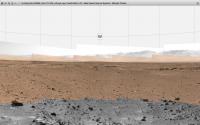
Posted by: Phil Stooke Jan 10 2014, 03:23 PM
"I got the cruise control locked in at 35"
A short hop to the 508 location - here's rough circular pan with what's available so far.
Phil

|
Posted by: Greenish Jan 10 2014, 03:54 PM
ChemCam mosaic from Sol 507. Fairly happy with how this one came out, & looking forward to what the color-merging experts might do.

|
(EDIT: I noticed on Joe's site that all 5 images are actually at same elevation, so replaced original with rotated version to make it level with horizon. I had been fooled by the visible tilt in the dune edge.)
Posted by: Zelenyikot Jan 10 2014, 06:26 PM
Wow! Your ChemCam panorama is amazing! I just was trying to add a colour.

|
Posted by: Phil Stooke Jan 10 2014, 06:59 PM
Fantastic - you guys are wizards!
Phil
Posted by: eoincampbell Jan 10 2014, 07:00 PM
Great ChemCam mosaics... does the laser reach these distant(>7m) targets?
Posted by: Phil Stooke Jan 10 2014, 07:10 PM
No - the laser is not used, only the remote imager part of it. The laser is restricted to targets within about 8 m, I think.
The target name database at PDS shows names for a couple of the early targets like these (Castle Mountain and Ameto). As the data releases catch up with where we are now we should get names for these sites.
Phil
Posted by: Greenish Jan 10 2014, 08:14 PM
Zelenyikot, wow, the color really makes it come alive - never expected something that good or that quick. Nice work!
Posted by: fredk Jan 10 2014, 10:28 PM
For context, this chemcam mosaic includes part of a large crater we've seen since the early days, and nearby fascinating features:
http://mars.jpl.nasa.gov/msl-raw-images/msss/00507/mcam/0507MR1991000000E1_DXXX.jpg
Posted by: atomoid Jan 11 2014, 02:07 AM
crosseye view of terrain from http://www.midnightplanets.com/web/MSL/image/00508/NRB_442598204EDR_F0250312NCAM00281M_.html I suppose we wont be veering http://curiosityrover.com/imgpoint.php?name=NRB_442598204EDR_F0250312NCAM00281M_ into that..
|
Greenish, thanks for pointing out that ready-baked http://www.midnightplanets.com/web/MSL/image/00506/0506ML1988008000E1_DXXX.html, must be a birthday coming up!
Posted by: udolein Jan 11 2014, 02:16 PM
MastCam drive movie Sol 504 - 508:
|
click on the thumbnail starts the animation.
(25m Sol 504-506 - 10m Sol 506-508)
Cheers, Udo
Posted by: jvandriel Jan 11 2014, 03:54 PM
The Mastcam L view on Sol 508.
Jan van Driel
|
|
Posted by: Astro0 Jan 12 2014, 08:24 AM
Two beautiful views of MSL's ChemCam and MastCam cameras from Sol 505.

|

|
Interesting bit of cracked coating just under the ChemCam 'eye' and a piece that's obviously dropped away.
There are some thumbnail images of the ChemCam that have come down. Nine images, 8 of them taken in 9 seconds (movie?) Need to wait for the full res to see if there's something else that they are looking at. Perhaps the MastCam image is looking to see if the missing fleck landed somewhere or maybe just part of a general inspection?
Great images... dare I say a new type of 'selfie'
Posted by: PaulH51 Jan 12 2014, 12:24 PM
The eight thumbnail images are probably for a 'stacked' focus image that will be processed on board before being downlinked later.
Posted by: fredk Jan 13 2014, 03:32 AM
I really like how the turret position and orientation is almost precisely the same in these two images relative to the FLB hazcam, even though the rover has moved and the arm is in a very different configuration. To see this, load up both these images in separate windows and flip from one to the other:
http://mars.jpl.nasa.gov/msl-raw-images/proj/msl/redops/ods/surface/sol/00508/opgs/edr/fcam/FLB_442590644EDR_F0250242FHAZ00216M_.JPG
http://mars.jpl.nasa.gov/msl-raw-images/proj/msl/redops/ods/surface/sol/00510/opgs/edr/fcam/FLB_442764135EDR_F0250312FHAZ00216M_.JPG
Is someone showing off?
Posted by: Ant103 Jan 13 2014, 09:44 AM
We're having a timespace breach !! Jake Matijevic rock is BACK !
http://mars.jpl.nasa.gov/msl-raw-images/proj/msl/redops/ods/surface/sol/00511/opgs/edr/ncam/NLB_442858852EDR_F0250510NCAM00284M_.JPG
See the right part. It's pretty weird to find a very similar shaped rock…
EDIT : Let's be serious again. Sol 511 Navcam pan
EDIT DE NANTES : Panorama updated ^^
http://www.db-prods.net/marsroversimages/Curiosity/2014/Sol511_pano.jpg
Posted by: Actionman Jan 13 2014, 01:32 PM
http://mars.jpl.nasa.gov/msl-raw-images/proj/msl/redops/ods/surface/sol/00508/opgs/edr/fcam/FLB_442590644EDR_F0250242FHAZ00216M_.JPG
http://mars.jpl.nasa.gov/msl-raw-images/proj/msl/redops/ods/surface/sol/00510/opgs/edr/fcam/FLB_442764135EDR_F0250312FHAZ00216M_.JPG
Is someone showing off?
Looks like their documenting an observation? Wonder if they will be using the brush any time soon?
Posted by: fredk Jan 13 2014, 03:39 PM
I'm not sure what you mean by "documenting an observation". The turret is in almost exactly the same position and orientation in the rover frame in the two images, even though the rover and arm have moved. Even the rocker-bogey has tilted.
All I can think of is this is a test of precision in positioning the turret. Or an incredible coincidence.
Posted by: Phil Stooke Jan 13 2014, 06:03 PM
Here's a circular version of Damia's sol 511 panorama.
Phil

|
Posted by: elakdawalla Jan 13 2014, 06:30 PM
All I can think of is this is a test of precision in positioning the turret. Or an incredible coincidence.
In both cases, the arm is in position to use MAHLI to photograph the wheels, so it makes sense that its position as seen from FHaz would be constant. It just goes to show that they can put MAHLI in exactly the same position and orientation with a variety of different arm configurations. Seeing as how they're now monitoring the wheels much more closely than they used to, I expect we'll see a lot more photos of the turret in that precise position -- should make for a fun animated gif after we've accumulated a few more.
Well spotted, fredk.
Posted by: Greenish Jan 13 2014, 06:54 PM
Maybe trying to reposition the arm shadow? Looks like opposite side's wheels are lit, though I didn't check when other images were taken. But re-positioning check makes sense too, for wheel monitoring repeatability. Or it could just be the contortions needed to get the necessary range of motion for certain imaging angles, though in that case I suspect we'd have seen it before.
Posted by: fredk Jan 13 2014, 08:42 PM
You're right. On each of those two sols, the MH wheel imaging began about 1 minute after the hazcam shots. But if you look at the MH wheel images, you can see that they don't point towards a fixed direction on the rover body on the two sols - presumably they try to compensate for movement of the rocker-bogey relative to the rover body (they want the wheels roughly centred, after all). So my guess is that the hazcam shots I linked to are in some kind of "standoff" position prior to wheel imaging. Perhaps by default they set it to the same direction with respect to the rover body.
But it is interesting that they can reproduce the pointing and position of the turret with different arm positions. That makes me wonder if there are just two such arm positions, or is there a continuum of arm positions that can give the same turret position/orientation? I would need a rover model to understand this...
Posted by: atomoid Jan 13 2014, 08:47 PM
long baseline crosseye detail extracted from sol http://www.midnightplanets.com/web/MSL/image/00506/0506ML1988004000E1_DXXX.html & http://www.midnightplanets.com/web/MSL/image/00508/0508ML1999000000E1_DXXX.html. I don't usually post these since they tend to be headache-generating this being slightly more approachable once you get the center focus, ok just barely FWIW...

|
Also as http://www.unmannedspaceflight.com/index.php?s=&showtopic=7747&view=findpost&p=206347 mentions its interesting to see http://www.unmannedspaceflight.com/index.php?act=attach&type=post&id=31893 on the chemcam housing..
Posted by: djellison Jan 13 2014, 10:00 PM
Use your right arm...it has the same degrees of freedom ( sort of ) as the MSL arm.
Point, with your right index finger.....at this
[X]
Now you can wiggle your elbow around, you can move your body even, whilst keeping your hand and finger in the same place, pointing the same way.
Posted by: ngunn Jan 13 2014, 10:22 PM
This reminds me of the Curiosity self portrait - many observations from the same position but with the arm in lots of different positions. Then it was done so the arm could be 'removed' from the mosaic. What is the objective in this case - avoiding shadowing?
Posted by: mcaplinger Jan 13 2014, 10:31 PM
I used to try to visualize it this way, but really MSL is much more constrained than your arm, since the center 3 of the 5 degrees of freedom are all constrained to be in a plane.
Hopefully the Lego model is correctly articulated; mine hasn't shown up yet. [Based on the box art it looks exactly right.]
Posted by: mcaplinger Jan 14 2014, 05:04 AM
Not exactly. The main goal of the self-portrait positioning was to keep the camera nodal point remained fixed in space, so no parallax effects would confuse mosaic generation. Not having the arm appear was a secondary goal, and given the number of times we've had to explain it, I sort of wish we had taken a version where you could see the arm.
Posted by: mars_armer Jan 14 2014, 03:39 PM
Since I worked on development of the arm (and also the MER IDD which had similar kinematics), I can answer this. Once you choose a position for the turret and a direction for the camera to point, there are exactly four sets of joint angles that can put the turret in that position/orientation. The four solutions come from a choice of elbow up/down and wrist up/down. There can't be a continuum of solutions, because the arm has five degrees of freedom and you are specifying five constraints (x, y, z coordinates and azimuth/elevation pointing). The camera roll angle can't be chosen independently, you just get what you get from the arm's kinematics. However, I'm pretty sure that the choice of which of the four solutions doesn't change the roll angle.
Not all four of the four solutions are actually possible, because of the limits on the range of motion of each joint and also because of possible interference between arm parts or with the rover. Chances are, the two poses you pointed out are the only two feasible poses to take this shot.
I'm not involved at all with operations, so I don't know WHY they would change poses like this. Very unlikely that it's to show off. It might have more to do with other activities, and trying to minimize the amount of motion in the overall sequence.
Posted by: fredk Jan 14 2014, 04:53 PM
Absolutely fascinating, mars_armer. So I guess that explains the need for 5 degrees of freedom for the arm - that's the minimum that gives you complete position and pointing control for the turret (up to various limitations, of course).
It looks like the series is continuing:
http://mars.jpl.nasa.gov/msl-raw-images/proj/msl/redops/ods/surface/sol/00512/opgs/edr/fcam/FLB_442949183EDR_F0250510FHAZ00216M_.JPG
This would make a very cool animation...
Posted by: Zelenyikot Jan 14 2014, 05:16 PM
Cool MAHLI animations from Russia (not my).
http://habrastorage.org/storage3/09c/ee4/ec2/09cee4ec2aec9738120bfb33338a9ebc.gif and http://habrastorage.org/storage3/902/18a/368/90218a3683634435dd9d8acd0d6cafc1.gif
Posted by: Paolo Jan 14 2014, 05:54 PM
dear old Denavit-Hartenberg matrix inversion...
Posted by: Actionman Jan 15 2014, 05:57 PM
http://mars.jpl.nasa.gov/msl-raw-images/msss/00512/mcam/0512MR2012000000E1_DXXX.jpg
Interesting rock, wonder if they'll use the bush on it?
|
Posted by: Phil Stooke Jan 15 2014, 06:02 PM
I think something got broken off that bit of the rock and rolled to Solander Point to become Pinnacle Island.
Phil
Posted by: Greenish Jan 16 2014, 04:58 PM
There's a pretty big stereo Mastcam panorama building up from sols 508-509. Not sure if I'll be able to get back to it, so here's my take on the ML portion available so far.
|
|
Posted by: Phil Stooke Jan 17 2014, 02:44 PM
Another drive on sol 515 - here's a half-pan in circular form to show the area.
Phil
|
Posted by: Zelenyikot Jan 17 2014, 04:02 PM
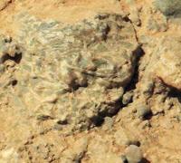
Very interesting rock. ChemCam on sol 513
|
Posted by: dvandorn Jan 17 2014, 04:44 PM
That looks like a conglomerate rock, but instead of being a matrix with rounded streambed-like inclusions (as we saw at Hottah) it looks like a lot of sharper fragments, arranged willy-nilly like a "dog's breakfast" and with far more inclusions than matrix. I'd even be thinking breccia, but the clasts are a lot sharper and flatter than I would normally expect to see in a breccia.
The individual shards of rock appear to be layered as well -- very fine layers, when you look at the scale of the image.
Oh, little rock, what stories do you have to tell?
-the other Doug
Posted by: elakdawalla Jan 17 2014, 05:01 PM
That is a cool rock, well spotted. I'd call those bright things "laths" and if it were on Earth I'd suspect an igneous or metamorphic rock and not a sedimentary rock right away. But this is Gale so....I don't know.
Posted by: serpens Jan 17 2014, 10:03 PM
I gather this is a float rock? Feldspar?
Posted by: tdemko Jan 17 2014, 10:54 PM
http://www.anr.state.vt.us/dec/geo/images/TibHIll.jpg like these! These are typically plagioclase feldspar phenocrysts in a rock that formed from a slowly cooled magma.
Hmmm, felsic/intermediate and deeper crustal, not your usual Mars float!
Posted by: atomoid Jan 18 2014, 12:08 AM
interesting messy wedgey http://www.midnightplanets.com/web/MSL/image/00513/0513MR2019001000E1_DXXX.html from:

|
Posted by: Actionman Jan 18 2014, 12:34 AM
Another photo is posted http://mars.jpl.nasa.gov/msl-raw-images/proj/msl/redops/ods/surface/sol/00514/opgs/edr/ccam/CR0_443121083EDR_F0250540CCAM02514M_.JPG Zelenyikot.
Posted by: elakdawalla Jan 18 2014, 12:40 AM
Hmmm, felsic/intermediate and deeper crustal, not your usual Mars float!
I always, always try to avoid making mineral diagnoses with only photographic evidence. One thing can look a lot like another thing. ChemCam had one of the laths in its crosshairs; if it's feldspar, we'll find out sooner or later. But I'm not gonna call it feldspar until somebody shows me a honking huge amount of aluminum and calcium or sodium.
Posted by: paraisosdelsistemasolar Jan 19 2014, 12:49 PM
Sol 517 ChemCam panorama:
http://imgur.com/XTYzdxa
Posted by: Cargo Cult Jan 19 2014, 02:41 PM
Don't think it's been posted anywhere yet, but I spotted a fun image sequence for the http://mars.jpl.nasa.gov/msl/multimedia/raw/?s=515&camera=NAV_RIGHT_. A quick bit of image assembly later, and https://hylobatidae.org/misc/msl-navcam-sol-515.gif. Watch those rocker-bogies rock!
(I've also just noticed similar sequences for the left navcam, and on Sols 511, 504 and 494. Ooh.)
Posted by: Phil Stooke Jan 19 2014, 04:17 PM
That's a great Chemcam mosaic. It suddenly made me think that a Phobos image from ChemCam would be really nice.
Phil
Posted by: Ant103 Jan 19 2014, 06:13 PM
Very good ChemCam mosaic A lot of details there !
Here, is Sol 514 Navcam panoramic, with a dramatic lighting
http://www.db-prods.net/marsroversimages/Curiosity/2014/Sol514_pano.jpg
Posted by: nprev Jan 19 2014, 06:15 PM
Wow.  REALLY stunning, Damia, thank you!
Re P.'s mosaic in his previous post: I didn't have high hopes for ChemCam at first; the initial images looked pretty fuzzy & of poor resolution. Happy to be proved wrong!
Posted by: scalbers Jan 19 2014, 09:29 PM
The dramatic lighting in Ant103's mosaic shows some interesting aspects of aerosol scattering. At the azimuth of the sun, we see both the brighter sky and the increased glow in front of the crater rim. This could give some information on the scale height of the aerosols present, along with the aerosol optical depth. A good example to try and render as well.
Posted by: dilo Jan 19 2014, 09:38 PM
Impressive!
Posted by: fredk Jan 20 2014, 02:33 AM
I think this is our first M100 view of the big crater on the Gale rim:
http://mars.jpl.nasa.gov/msl-raw-images/msss/00513/mcam/0513MR2020000000E1_DXXX.jpg
Posted by: dilo Jan 20 2014, 06:29 AM
I made a fast stitch of 3 frames showing more of the rim with a contrast enhancement:

|
Posted by: Ant103 Jan 20 2014, 02:49 PM
Thank you all
But I had to make a postcard of it, and a colorized one.
Done
http://www.db-prods.net/blog/2014/01/20/fin-de-journee-au-sol-512-sur-gale-carte-postale-by-curiosity/
Posted by: dilo Jan 20 2014, 03:16 PM
This postcard is stunning and colorization is a masterpiece, brava!!!
(already my new desktop )
Posted by: vikingmars Jan 20 2014, 03:17 PM
But I had to make a postcard of it, and a colorized one. Done How nice Damia ! Thanks to you also !
Posted by: Phil Stooke Jan 20 2014, 03:49 PM
Circular pan for sol 518.
Phil

|
Posted by: Phil Stooke Jan 21 2014, 02:18 PM
http://curiositymsl.com/track.jpg
Oh dear - have we lost our Curiosity log website? Joe - will it reappear?
Phil
Posted by: Phil Stooke Jan 21 2014, 03:30 PM
Here's the (semi)circular pan for sol 519.
Phil

|
Posted by: redmoon Jan 21 2014, 03:46 PM
A new URL for the Curiosity log website : http://curiositylog.com/
Mirko
Posted by: Ant103 Jan 21 2014, 05:31 PM
Thank you SO much for your very nice comments This is encouraging to continue to this path
Sol 519 Navcam panoramic. I'm impressed of how the skyline has changed bewtween the previous sols
http://www.db-prods.net/marsroversimages/Curiosity/2014/Sol519_pano.jpg
Posted by: dilo Jan 21 2014, 06:56 PM

BUT url of link to map/speed-plots need to be updated!
Posted by: Phil Stooke Jan 22 2014, 03:27 PM
This is the sol 520 half-pan in circular form - we turned south. That intriguing gap in the scarp to the west is blocked by a big drift, but we will be seeing a lot more of that kind of landscape soon.
Phil
|
Posted by: Ant103 Jan 22 2014, 04:35 PM
Sol 520 Navcam pan
http://www.db-prods.net/marsroversimages/Curiosity/2014/Sol520_pano.jpg
And Sol 519 Mastcam34 :
http://www.db-prods.net/marsroversimages/Curiosity/2014/Sol519_Mastcam34.jpg
Posted by: elakdawalla Jan 22 2014, 09:32 PM
So glad Ken Herkenhoff is putting more place/target names in his updates. http://astrogeology.usgs.gov/news/astrogeology/sol-520-update-on-curiosity-from-usgs-scientist-ken-herkenhoff-no-rest-for-the-rover:
Posted by: Phil Stooke Jan 22 2014, 10:11 PM
Me too!
Phil
Posted by: mhoward Jan 22 2014, 10:19 PM
Me three. Having something to label sites and sols with is great. (Now I have to get citations working in my content management so I can reference where these names are coming from.)
Posted by: vikingmars Jan 23 2014, 12:02 AM
Meanwhile, on Mars...

|
Enjoy this peaceful view
Posted by: PaulH51 Jan 23 2014, 04:55 AM
Location of the intriguing gap in the scarp to the west...

|
Posted by: elakdawalla Jan 23 2014, 05:09 AM
Cool. I hadn't appreciated how neatly that wind drift was parked across the gate between those two little highlands.
Posted by: Olivier Jan 23 2014, 01:36 PM
Any idea if the planned route is going "through the gates" ?? That would give an awesome panorama!
(I will reserve my comparison to the Black Gate of Mordor for the 'Humor and other stuff' chat)
Would it be interesting science-wise, though?
Posted by: Phil Stooke Jan 23 2014, 01:54 PM
Not that gate! The big drift would be a potential hazard. But there are several places like that coming up in the next few months.
Phil
Posted by: PaulH51 Jan 23 2014, 02:55 PM
Besides the hazard that would be encountered trying to traverse that big drift, there are a number of other potential hazards that may best be avoided at this stage. These are revealed in much more clarity in the following MC-100 image. We can be assured that the rover drive team will select the least hazardous path for the journey to the next science 'way-point', and onward to the entry point for Mt Sharp....One thing is certain at this point, that path is going to offer us some challenges as well as spectacular images en-route http://www.midnightplanets.com/web/MSL/image/00517/0517MR2038000000E2_DXXX.html
Posted by: fredk Jan 23 2014, 03:37 PM
For the planned route, look at http://mars.jpl.nasa.gov/msl/multimedia/images/?ImageID=5533 It shows us diverting southwards around the "gate". (I think she likely could have made it through, perhaps along the left side. But of course there will be plenty of opportunities for sightseeing as we reach the base of the mountain...)
Posted by: Olivier Jan 23 2014, 03:41 PM
From the picture, any estimation of the dune "height" ?
Has the rover been ever tested on a pure sand test ground?
Posted by: Phil Stooke Jan 23 2014, 04:08 PM
Yes, it's been tested on everything it's likely to encounter.
This is a circular view of the sol 521 position - only a short drive, but I may have to correct this position a bit.
Phil

|
Posted by: RoverDriver Jan 23 2014, 04:37 PM
That image was taken after my request. The idea was to try to better understand how HiRISE view of this feature relates to surface imaging. We had a M34 view of that area from a previous Sol and wanted a closer view of it. I'm thankful to the MASTCAM team to let me use their awesome camera to take a peek. Regarding the height of that dune, I estimated about 60-80 cm but I am unsure if we see the base of the dune or if there are occlusions.
EDIT: difficult to tell but it could be even 1 meter tall in some places.
Paolo
Posted by: elakdawalla Jan 23 2014, 04:41 PM
Thanks so much for the insight into the mission's thinking, Paolo Not having done the math, my impression of the drift was that it was much taller!
http://www.planetary.org/blogs/emily-lakdawalla/2012/05141204.html
Posted by: Ant103 Jan 23 2014, 04:57 PM
Phil, maybe you can update your polar projection with this Sol 521 panoramic
http://www.db-prods.net/marsroversimages/Curiosity/2014/Sol521_pano.jpg
Posted by: Tesheiner Jan 23 2014, 05:54 PM
This drift blocking the gate remind me of when Spirit was going from El Dorado to Home Plate. There were similar drifts on the path and on sol 716 she reached a quite big one on the way. And that's what happened when attempting to avoid it going around the right side: http://www.unmannedspaceflight.com/index.php?s=&showtopic=1969&view=findpost&p=36257
http://marsrovers.jpl.nasa.gov/mission/status_spiritAll_2006.html#sol715?
Posted by: elakdawalla Jan 23 2014, 06:03 PM
Just chatted with Ashwin Vasavada about this feature and they don't have a name for it though he referred to it in our conversation as a "chute."
Posted by: Gerald Jan 24 2014, 12:25 AM
http://curiosityrover.com/ is alive again. Thanks so much, Joe!
Posted by: fredk Jan 24 2014, 01:02 AM
I second that! I think it's the best MSL browsing site period.
Posted by: atomoid Jan 24 2014, 03:12 AM
Cant argue with that, though its hard to play favorites between the Midnight Planets and Joe's site, thy serve different purposes and tastes.
..now if Joe and Moe would merge their sites together into some sort of super-hybrid we would surely have Midnight MoJoe Mars Madness!
Posted by: mhoward Jan 24 2014, 05:07 AM
Just for clarity's sake: my name is Mike, not Moe. You're thinking of http://en.wikipedia.org/wiki/Moe_Howard... completely different Stooge.
Posted by: fredk Jan 24 2014, 06:48 AM
Absolutely right. It would be hard to live without either.
Posted by: Gerald Jan 24 2014, 10:05 AM
Sol 521 Front Right Hazcam B 4-image sequence, 125 degrees de-fisheye, shows MAHLI while imaging wheels, and driving a bit between images:
http://imgur.com/10paXDe
Posted by: Ant103 Jan 24 2014, 11:26 AM
Sol 519 Navcam pan is now complete
http://www.db-prods.net/marsroversimages/Curiosity/2014/Sol519_pano.jpg
Posted by: Phil Stooke Jan 24 2014, 04:46 PM
Now I can use a couple of Damia's new panoramas to update my circular views.
Sol 519:

|
Sol 521:

|
Phil
Powered by Invision Power Board (http://www.invisionboard.com)
© Invision Power Services (http://www.invisionpower.com)