The Geology of Jezero Crater, Observations & Findings |

The Geology of Jezero Crater, Observations & Findings |
 Feb 24 2021, 01:41 AM Feb 24 2021, 01:41 AM
Post
#1
|
|
|
Merciless Robot  Group: Admin Posts: 8783 Joined: 8-December 05 From: Los Angeles Member No.: 602 |
This thread is for those rockhounds among us to discuss the new terrain we'll see as Perseverance scoots around her new home. Let's get dirty & technical!

-------------------- A few will take this knowledge and use this power of a dream realized as a force for change, an impetus for further discovery to make less ancient dreams real.
|
 |
 
|
 |
|
Feb 24 2021, 01:51 AM
Post
#2
|
|
 Member Group: Members Posts: 684 Joined: 24-July 15 Member No.: 7619 |
QUOTE (nprev @ Feb 24 2021, 02:41 AM)  This thread is for those rockhounds among us to discuss the new terrain we'll see as Perseverance scoots around her new home. Let's get dirty & technical! Rule #1 The physical processes of weathering can cause rocks to move in ways you don't expect. 
|
|
|
|
|
Feb 24 2021, 02:13 AM
Post
#3
|
|
|
Newbie Group: Members Posts: 2 Joined: 20-September 09 Member No.: 4948 |
Is it indeed "Geology" and not "Aresology" or some-such?
|
|
|
|
|
Feb 24 2021, 02:31 AM
Post
#4
|
|
|
Member Group: Members Posts: 684 Joined: 24-July 15 Member No.: 7619 |
QUOTE (dougkeenan @ Feb 24 2021, 03:13 AM) Is it indeed "Geology" and not "Aresology" or some-such? testing the mod's patience I've gone with the rule that "*-ology" is research done by an on site "*-ologist". By my measure, we have lots of "geologists", only 12 Apollo "seleneologists", and we're eagerly waiting for "aresologists". |
|
|
|
|
Feb 24 2021, 02:52 AM
Post
#5
|
|
|
Solar System Cartographer Group: Members Posts: 10162 Joined: 5-April 05 From: Canada Member No.: 227 |
This has been a discussion since the 1960s. I remember a very good piece on it in a paper about Mars by Luciano B. Ronca in about 1965.
This is how it works. 'geo-' means land, not planet Earth, though it can be used for the planet by extension from the main idea. Geography is the study and depiction of different lands (around the Mediterranean, originally, for the Greeks). Geology is the study of what the land is made of. Geomorphology is the study of the shape of the land and how it is shaped. Geodesy of course is extending the concept to the planet, but at its root 'geo-' means land. And another point if that's not enough. If geology is the study of the Earth, we can have Selenology for the Moon and Areology for Mars, but how far do you want to take it? A different word for the study of every planet, moon and asteroid? Will Callistologists meet Ceresologists and Enceladologists at LPSC? Ultimately that is a ludicrous situation for people who are all doing the same kind of work, so a common term is desirable, and the one we use is 'geology'. Phil -------------------- ... because the Solar System ain't gonna map itself.
Also to be found posting similar content on https://mastodon.social/@PhilStooke Maps for download (free PD: https://upload.wikimedia.org/wikipedia/comm...Cartography.pdf NOTE: everything created by me which I post on UMSF is considered to be in the public domain (NOT CC, public domain) |
|
|
|
|
Feb 24 2021, 03:11 AM
Post
#6
|
|
|
Junior Member Group: Members Posts: 94 Joined: 11-August 12 Member No.: 6536 |
|
|
|
|
|
Feb 24 2021, 03:32 AM
Post
#7
|
|
|
Member Group: Members Posts: 684 Joined: 24-July 15 Member No.: 7619 |
QUOTE (Phil Stooke @ Feb 24 2021, 03:52 AM) And another point if that's not enough. If geology is the study of the Earth, we can have Selenology for the Moon and Areology for Mars, but how far do you want to take it? A different word for the study of every planet, moon and asteroid? Will Callistologists meet Ceresologists and Enceladologists at LPSC? Ultimately that is a ludicrous situation for people who are all doing the same kind of work, so a common term is desirable, and the one we use is 'geology'. Phil Well said. However, I DO look forward to a time when we have "A different word for the study of every planet, moon and asteroid." In much the same way we say "Doctor" in general but then differentiate between phlebotomist, proctologist and optometrists. Ideally, we have "*-ologists" who work on site. However, if we get to the wonderful stage where people can devoting their careers to the research of an individual world, with unique combinations of composition and what components are solid, liquid or gas (e.g. water on Mercury, Earth, Pluto) then we should call the people who "learn that world" by the name of that place they know like a second home. If we can accept about 75 medical "specialties", we can accept world-specific "specialties." QUOTE PHYSICIAN CODING
• Adult Intensivist • Allergy • Anesthesia • Bariatric Medicine/Surgery • Burn/Trauma • Cardiac Catheterization • Cardiology • Cardiovascular Surgery • Colorectal Surgery • Dermatology • Electrophysiology • Emergency Medicine • Endocrinology • Family Practice • Gastroenterology • General Surgery • Geriatrics • Gynecologic Oncology • Hematology/Oncology • Hepatobiliary • Hospitalist • Infectious Disease • Internal Medicine • Interventional Radiology • Medical Genetics • Neonatology • Nephrology • Neuroradiology • Neurology • Neurosurgery • Nuclear Medicine • Obstetrics & Gynecology • Occupational Medicine • Ophthalmology • Oral Surgery • Orthopedics • Otolaryngology / Head & Neck Surgery • Pain Management • Palliative Care • Pain Management • Palliative Care • Pathology: Surgical & Anatomic • Pediatric Intensivist • Pediatrics • Pediatric Surgery • Physical Medicine • Plastic & Reconstructive Surgery • Podiatric Surgery • Psychiatry • Pulmonary Medicine • Radiation Oncology • Radiology • Rheumatology • Surgical Oncology • Thoracic Surgery • Transplant Surgery • Urology • Vascular Surgery • Wound Care ASC SPECIALTIES • Bariatric Surgery • ENT • General Surgery • Gastroenterology • Neurosurgery • Obstetrics & Gynecology • Ophthalmology • Oral/Dental Surgery • Orthopedic Surgery • Pain Management • Pediatric Surgery • Plastic Surgery • Podiatric Surgery • Urology • Vascular Surgery HOSPITAL CODING • Ambulatory Clinics • Cardiac Catheterization Labs • Diagnostic Radiology • Emergency Department • GI Endoscopy Labs • Inpatient Acute Care • Interventional Cardiology • Interventional Radiology • Same Day Surgery • Small Specialty Hospitals • Surgical Pathology HCC AUDITS • HCC Audits AMBULANCE CODING • Ambulance Coding |
|
|
|
|
Feb 24 2021, 04:32 AM
Post
#8
|
|
|
Senior Member Group: Members Posts: 1583 Joined: 14-October 05 From: Vermont Member No.: 530 |
Because this forum is now old enough to drive, there is of course a thread for this topic of semantics:
http://www.unmannedspaceflight.com/index.php?showtopic=6615 |
|
|
|
|
Feb 24 2021, 04:41 AM
Post
#9
|
|
 The Insider Group: Members Posts: 669 Joined: 3-May 04 Member No.: 73 |
QUOTE (HSchirmer @ Feb 23 2021, 07:32 PM) However, I DO look forward to a time when we have "A different word for the study of every planet, moon and asteroid." Ideally, we have "*-ologists" who work on site. However, if we get to the wonderful stage where people can devoting their careers to the research of an individual world, How would you then distinguish a volcanologist from a geologist on Mars, just to name one? Or how about meteorologist? They are all *-ologists. I think just adding the name of the rock in front of the field of study is sufficient: "Mars geologist". Simple, effective, everyone knows the subject. No need to invent new words. Absent the name and it's implicit that it's Earth. |
|
|
|
|
Feb 24 2021, 07:16 AM
Post
#10
|
|
|
Merciless Robot Group: Admin Posts: 8783 Joined: 8-December 05 From: Los Angeles Member No.: 602 |
....aaaand, were done with the pedantry.
Let's talk about rocks. On Mars. -------------------- A few will take this knowledge and use this power of a dream realized as a force for change, an impetus for further discovery to make less ancient dreams real.
|
|
|
|
|
Feb 24 2021, 07:34 AM
Post
#11
|
|
|
Senior Member Group: Members Posts: 1044 Joined: 17-February 09 Member No.: 4605 |
QUOTE (nprev @ Feb 24 2021, 07:16 AM) ....aaaand, were done with the pedantry. Let's talk about rocks. On Mars. Thank you nprev! |
|
|
|
|
Feb 24 2021, 09:48 AM
Post
#12
|
|
|
Junior Member Group: Members Posts: 52 Joined: 1-March 11 From: Houston, USA Member No.: 5860 |
QUOTE (Don1 @ Feb 23 2021, 09:11 PM) Some resources: A recent USGS geological map of the Jezero Crater region (big pdf) LPSC 2021 abstract: Mineralology of Jezero LPSC 2021 abstract: Jezero floor unit LPSC 2021 abstract: Carbonates in Jezero The link above to the abstract on carbonates in Jezero is an inadvertent duplicate of link to the the Jezero floor abstract. This is the correct link to the abstract on carbonates in Jezero: LPSC 2021 abstract: Carbonates in Jezero |
|
|
|
|
Feb 24 2021, 05:00 PM
Post
#13
|
|
 Senior Member Group: Members Posts: 2530 Joined: 20-April 05 Member No.: 321 |
For now, we have a mission that'll be exploring that floor unit, which isn't the reason why Perseverance came to Jezero but it's a matter of fate that we'll have the best set of instruments ever to reach another planet rolling over and exploring that. We're going to read the history of Mars in reverse, which is quite different from Curiosity, which hit oldest units in Gale early, then rolled upwards and forwards in time.
I like the Hundal, et al paper that compares the Jezero layering with that of Isidis. I wonder about Jezero vs. Gusev. For Spirit, the floor unit was a showstopping barrier that prevented the rover from making any direct contact with the history of the river+lake environment. The Columbia Hills ended up being a bit of a consolation prize, and a surprise, where water vented upwards after the lake was gone. I don't know if Perseverance will find anything similar in Jezero, and I doubt it, since we can see the 2km to the delta and it looks flat, but maybe there'll be some equivalent. In the short term, I think we're going to learn about the nature of a sort of "impact gardening" that took place on a massive scale on Mars, flinging rocks and boulders long distance, mantling the ancient landscapes. As such, I can't see any reason why it would be very different here than in Gusev, but maybe the individual regional impacts will make for a different story. I'm struck by how many rocks peeking up through the sand and dust seem to hold to one general contour just at or very slightly above the surface. Does this mean that erosion has worn a once-deeper layer down a bit, and if so, what was so effective in planing these rocks down? Chemical or aeolian erosion? |
|
|
|
|
Feb 24 2021, 08:06 PM
Post
#14
|
|
|
Member Group: Members Posts: 684 Joined: 24-July 15 Member No.: 7619 |
QUOTE (JRehling @ Feb 24 2021, 05:00 PM) I'm struck by how many rocks peeking up through the sand and dust seem to hold to one general contour just at or very slightly above the surface. Does this mean that erosion has worn a once-deeper layer down a bit, and if so, what was so effective in planing these rocks down? Chemical or aeolian erosion? I'd guess a basin wide layer of hard sediment, could also be "natural cement" or caliche. I'm in the "Newark Basin" area that stretches from Lancaster Pa to New York City. Material laid down in anaerobic deep lakes during wet conditions is very hard stone, while material laid down in shallow oxidizing water on the dry lake is very soft stone. There are several very hard layers of rock laid down in paleo lake Newark which you can easily trace for over 70 miles. You'd expect a similar effect in Jezro for large areas of horizontal sediment- material laid down in wet times should be harder and form resistant "terraces". Interesting, in Newark basin, they're tracing climate variations / Milankovich cycles by reading oxidation states of the rock. They're actually THEN using that data to recreate what Earth's orbit, precessions and tilts were. This circumvents the chaos / "the butterfly effect" which generally precluded accurate simulations of Earth's orbital characteristics backward more that about 60 million years ago, by actually "reading" what the values were from 223 million to 199 million years ago. It should be VERY interesting to see if Curiosity and Perseverance can achieve something similar on Mars! QUOTE Mapping Solar System chaos with the Geological Orrery
https://www.pnas.org/content/pnas/116/22/10664.full.pdf |
|
|
|
|
Feb 24 2021, 09:55 PM
Post
#15
|
|
|
Senior Member Group: Members Posts: 2530 Joined: 20-April 05 Member No.: 321 |
What we see now in the near distance is not thought to be sedimentary layers formed in the lake. It is material emplaced as ejecta from impacts and aeolian deposits. Perseverance is not resting on the bottom of the lake. It is resting on material that is covering the bottom of the lake.
https://pubs.er.usgs.gov/publication/sim3464 "Volcanic ash or eolian airfall deposit that drapes underlying topography." |
|
|
|
|
Feb 25 2021, 12:48 AM
Post
#16
|
|
|
Member Group: Members Posts: 684 Joined: 24-July 15 Member No.: 7619 |
QUOTE (JRehling @ Feb 24 2021, 09:55 PM) What we see now in the near distance is not thought to be sedimentary layers formed in the lake. Agreed - I was thinking about the delta and Van Houten cycles. QUOTE (Cyclicity @ Climate , and Time scales") Orbital forcing in the Newark basin is revealed as a hierarchy of lake level cycles that controlled by precipitation and evaporation changes controlled by precession-related celestial mechanical cycles.
 https://www.ldeo.columbia.edu/~polsen/nbcp/cyclcicity.html |
|
|
|
|
Feb 25 2021, 02:16 AM
Post
#17
|
|
|
Senior Member Group: Members Posts: 1044 Joined: 17-February 09 Member No.: 4605 |
The consensus seems to be that the crater floor was flooded by lava some 300 million years after the lake dried up which embayed sedimentary/deltaic deposits. There has been some erosion of the delta material since then so a proportion of the aeolian deposit that JRehling noted drapes underlying topography could well be of deltaic origin. The area west of the Isidis basin, including Jezero crater reveals olivine‐carbonate lithology; in Jezero crater concentrated at the Western rim with some deposits in the delta. Given the dearth of carbonates elsewhere despite what seems to have been plentiful water in a CO2 atmosphere it will be really interesting if Perseverance can determine why it was preserved in this particular area.
JRehling...." I think we're going to learn about the nature of a sort of "impact gardening" that took place on a massive scale on Mars." Most possible, but using that term here is akin to lighting a blue touch paper. |
|
|
|
|
Feb 25 2021, 04:29 PM
Post
#18
|
||
|
Senior Member Group: Members Posts: 2530 Joined: 20-April 05 Member No.: 321 |
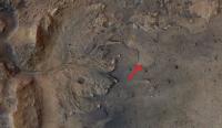
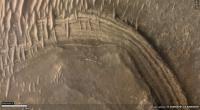
One detail in the Sol 3 panorama that's especially informative is the northernmost (furthest right) delta face. I cropped it and moreover turned up contrast in the red channel to bring out a subtle color contrast.
The first thing I notice is that here, as elsewhere, the delta's eastern slopes are mainly smooth, with the expected sedimentary layers covered. The layers are visible, though, more than in other places in the delta. The route plans we've seen would never bring Perseverance close to this area, instead heading well south, where outcroppings are from the landing site hard to see. The mission team may gamble that with any route that ascends the delta, the layers will nonetheless make themselves apparent closer up. I'm also struck by the fact that the layers are not horizontal. There has been tilting since the lake dried up. My manipulation of the color contrast was intended to explore the smooth mantling of the delta slope, and I think the patchy variation speaks to two types of material. The darker, greener material appears to be talus derived from the delta itself, while the brighter, redder material is the global coating of dust, which is universally present in this photo in the near distance, the far distance, and atop the delta. What's not clear is how much the contrast seen in the patchiness has to do with changes in texture versus abundance of one material versus the other, but that may be one and the same: Where larger pieces of talus exist, we see the rough sides of them, and elsewhere, the global dust unit covers it up. As Perseverance approaches the delta, we will begin to see more pieces of the delta that moved downslope. However, the area just east of and below the delta will likely be a jumble of pieces from different layers, and while each of those rocks will be individually interesting, the jumbling will deny us information about which piece came from which layer, and may be something the mission planners choose to move past fairly quickly, opting to get sooner up and to the layers themselves, where each unit studied will come with the context provided of which unit in the delta is that unit's home.
Attached thumbnail(s)
|
|
|
|
|
|
|
Feb 25 2021, 06:15 PM
Post
#19
|
|
|
Member Group: Members Posts: 684 Joined: 24-July 15 Member No.: 7619 |
QUOTE (JRehling @ Feb 25 2021, 04:29 PM) I'm also struck by the fact that the layers are not horizontal. There has been tilting since the lake dried up. Most river delta deposits slope downward when they hit a much larger lake or ocean. Similarly, the first sediment to drop out of the current is the heaviest- the largest and most incompressible gravel and grit. The further from the delta mouth you get, the finer, and more "hydrated" the sediment becomes. When the delta is eventually compressed or dries out, there's more "shrinkage" in the more distant sediment beds. |
|
|
|
|
Feb 26 2021, 09:44 PM
Post
#20
|
|
|
Member Group: Members Posts: 248 Joined: 25-February 21 From: Waltham, Massachussetts, U.S.A. Member No.: 8974 |
Delta erosion
At distances of a few hundered meters to a kilometer away from the current edge of the main delta deposits, there are a few isolated hills which could be classified as Inselbergs or outliers. Here is an example: https://mars.nasa.gov/maps/location/?mission=M20&site=jez&mapLon=77.40930318832399&mapLat=18.444092466139594&mapZoom=15&globeLon=77.42958068847659&globeLat=18.463327291058505&globeZoom=12&globeCamera=0,-4882.8125,0,0,1,0&panePercents=0,100,0&on=Current Position$1.00,Waypoints$1.00,Surface View$1.00,Landing Ellipse$1.00,Rover Path$1.00,Labels$1.00,Basemap$1.00,North East Syrtis Base Map$1.00://https://mars.nasa.gov/maps/location...e Map$1.00 A typical, geological interpretation of such isolated hills is that they were once connected to a main, better preserved area, here the delta, and became disconnected by erosion. The Inselbergs would be therefore witnesses to a former, larger extent of the delta, and in german such features are called Zeugenberg (witness = Zeuge). Given the similar appearance in terms of height and a flat top and a spatial correlation with the edge of the delta, this to me would be the preferred interpretation of the formation of this hills. This could be tested by examining the local stratigraphy of the delta and the hills with the expectation that there should be a good match. If this is the case, the delta was eroded back from its largest extent. This is to be expected during the time when the lake started to retreat to below delta levels. The current, abrupt edge of the delta is also more likely to have been shaped by erosion than being an original feature. Growing deltas tend to taper out into deeper water and transition into fans, leading to gentle slopes of a few degrees. One question then becomes where did the significant mass of eroded delta sediments go ? Perhaps there have been mass balance studies but one possible candidate is the smoother appearing material covering the plane just below the slope of the delta in a ring a few km wide in places. This ring appears to be less cratered than the center of the crater. Following the discussion it is also possible that the youngest sediments now are exclusively aeolian, and from impact dust and debris, and that eroded, reworked, and redeposited delta sediments are completely hidden below a top soil, accreted layer. And beneath both of those, there could be original lake bottom sediments. So it may make sense to investigate the craters closer to the rover which could have excavated deeper lake bottom sediments. But the safest place to get fluvial, water dominated, pristine material for sampling is probably right at the face of the current edge of the delta. A few thoughts, mainly on the importance of the outliers surrounding the current delta. -------------------- --
Andreas Plesch, andreasplesch at gmail dot com |
|
|
|
|
Feb 26 2021, 11:37 PM
Post
#21
|
|
|
Member Group: Members Posts: 684 Joined: 24-July 15 Member No.: 7619 |
QUOTE (Andreas Plesch @ Feb 26 2021, 10:44 PM) Delta erosion Excellent summary.... A few thoughts, mainly on the importance of the outliers surrounding the current delta. So, have any graduate students made a vacuum-formed crater and experimented with filling it with sediments and varying the water / sediment ratio to see what it takes to recreate the delta? (Asking as "that kid" who filled the little red wagon with cement, sand & stone, dropped marbles to create craters for an "authentic" moonscape for the Mattel 'Space 1999 Eagle' to land on...) |
|
|
|
|
Feb 27 2021, 12:00 AM
Post
#22
|
||
|
Senior Member Group: Members Posts: 1044 Joined: 17-February 09 Member No.: 4605 |
Good post Andreas. The isolated hills have been nominated by some as delta remnants although I haven't been able to find confirmation that their minerology matches the delta. If they are remnants then the erosion between them and the delta must have occurred in the (geologically short) gap between the crater drying and the lava flood. The attached image shows that the lava embayed the delta and I have marked what may be an example of embayed delta material eroding down below the lava level. But the lava would have covered the delta bottom sets and part of the foresets, preventing further erosion of the lighter materials. Jezero is a big crater and aeolian eroded material from the delta would not be particularly evident.
Attached thumbnail(s)
|
|
|
|
|
|
|
Feb 27 2021, 12:41 AM
Post
#23
|
|||
|
Member Group: Members Posts: 684 Joined: 24-July 15 Member No.: 7619 |
QUOTE (serpens @ Feb 27 2021, 12:00 AM) If they are remnants then the erosion between them and the delta must have occurred in the (geologically short) gap between the crater drying and the lava flood. Question- why couldn't that be later aeolian weathering? Similar to what roto-rootered away hundreds of meters / yards of sediment at Gale crater? Is there a consensus about whether the deposit is ash, (dry then flooded, or deposited in a lake) or extrusive lava?
Attached thumbnail(s)
|
||
|
|
|
||
|
Feb 27 2021, 02:20 AM
Post
#24
|
|
|
Member Group: Members Posts: 248 Joined: 25-February 21 From: Waltham, Massachussetts, U.S.A. Member No.: 8974 |
QUOTE (HSchirmer @ Feb 26 2021, 07:41 PM) Question- why couldn't that be later aeolian weathering? Similar to what roto-rootered away hundreds of meters / yards of sediment at Gale crater? Is there a consensus about whether the deposit is ash, (dry then flooded, or deposited in a lake) or extrusive lava? Well, I admit I did not take a detailed look at the latest geologic map, linked above, before. But it more or less confirms a few of my assumptions. The outliers are indeed mapped as the same unit (NHjf2, Jezero fan unit 2) as the main delta, and it explains that the Jezero floor unit (Njf) is covered near the delta by a smooth layer: "Dark, smooth surface texture near unit NHjf2 is due to a dark mantle deposit or erosional lag derived from erosion of unit NHjf2.". The Jezero floor unit itself is revised from lava flood flow to ash and/or aeolian airfall deposits (not sure if that was by consens), and is older than the delta, but still seen as lacustrine, so possibly deeper water deposits. In addition there should also be clastic, distal flan floor deposits. These may have been mostly muddy and as such more easily blown away once the lake bed was exposed as they are not to be found. The floor unit then embays and sits above the Lower etched unit, also seen as volcanic ash falling into the lake. Thanks, serpens, for pointing out that nice contact. It looks to me like an erosional window into that deeper unit which is also lacustrine. Delta erosion could have occurred by water in the manner of retreating waterfalls which is geologically efficient and does not take much geologic time (cm to m per year if water is regularly flowing). [Still strange to me looking at preserved billions of years old units, possible on a planet without plate tectonics which just sits there.] The geologic map shows hills or outliers about 2km to the _east_ of the rover, as Jezero fan unit 2, farther from the delta as I first thought. This would mean that the delta was perhaps about double the radial length, or 4 times the area (and volume and mass ignoring changes in thickness), at an earlier point than what remains today. Hard to see that all that eroded material could have been transported very far away but it looks like it could have been. perhaps even out of the crater into the regional sink, Isidis Planitia ? The nice lobes of the delta as seen today could have been preserved by preferential erosion preserving orginally larger lobes. Perhaps the outliers are remnants of just the larger lobes reaching out into the basin. -------------------- --
Andreas Plesch, andreasplesch at gmail dot com |
|
|
|
|
Feb 27 2021, 03:28 AM
Post
#25
|
|
|
Senior Member Group: Members Posts: 1044 Joined: 17-February 09 Member No.: 4605 |
The possibility that the mafic floor unit is sedimentary has been floated for some time but the general consensus is that it is a volcanic deposit. As with Curiosity I am sure that Perseverance will clarify satellite assessments of this part of Jezero. Shahrzad et al. Crater Statistics on the Dark‐Toned, Mafic Floor Unit in Jezero Crater, Mars (Geophysical Research Letters) determined the average thickness of this deposit at the margins to be ~13.0 ± 0.8 m. https://www.hou.usra.edu/meetings/lpsc2020/pdf/1608.pdf raises the possibility that it could be pyroclastic rather than effusive.
HSchirmer's question on whether the gap between outliers and the delta could be later aeolian erosional is well taken. My take is that if this were so then the mafic deposit would have embayed the area rather than covering it. However we will probably need to wait for next years LPC to get Perseverance's analysis. |
|
|
|
|
Feb 27 2021, 01:33 PM
Post
#26
|
|
|
Member Group: Members Posts: 684 Joined: 24-July 15 Member No.: 7619 |
QUOTE (serpens @ Feb 27 2021, 03:28 AM) The possibility that the mafic floor unit is sedimentary has been floated for some time I guess that's where we're talking past each other - I'm thinking of ashfall into a lake as sedimentary, I seems like you're considering ashfall as volcanic? I have to admit, that's a tough call to make... QUOTE UNDERSTANDING THE CONTINUITY OF REGIONAL UNITS IN THE MARS 2020 JEZERO AND NORTHEAST SYRTIS REGIONS: IMPLICATIONS FOR THE ORIGIN OF THE MAFIC UNIT(S). 50th Lunar and Planetary Science Conference 2019 (LPI Contrib. No. 2132) "If so, the presence of this mafic unit across a large regional extent and its draping occurrence on topographic slopes (especially on Jezeros rim) is highly suggestive of clastic deposition, perhaps via airfall, rather than by a volcanic flow origin." "If the mafic unit is indeed the same unit at both NE Syrtis and Jezero, then this would likely preclude a volcanic flow origin n3 and instead favor a draping emplacement mechanism, such as ashfall deposition or other clastic sedimentary mechanism. " https://www.hou.usra.edu/meetings/lpsc2019/pdf/2271.pdf |
|
|
|
|
Feb 27 2021, 04:47 PM
Post
#27
|
|
|
Member Group: Members Posts: 154 Joined: 8-June 04 Member No.: 80 |
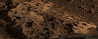
Does anyone know which rock Perseverance will examine first? Could it be the one with the "holes" in it right next to one of its wheels?
|
|
|
|
|
Feb 27 2021, 05:22 PM
Post
#28
|
|
|
Solar System Cartographer Group: Members Posts: 10162 Joined: 5-April 05 From: Canada Member No.: 227 |
No news on that yet. Things are just ramping up after the software switch so we will see soon.
Phil -------------------- ... because the Solar System ain't gonna map itself.
Also to be found posting similar content on https://mastodon.social/@PhilStooke Maps for download (free PD: https://upload.wikimedia.org/wikipedia/comm...Cartography.pdf NOTE: everything created by me which I post on UMSF is considered to be in the public domain (NOT CC, public domain) |
|
|
|
|
Feb 27 2021, 05:38 PM
Post
#29
|
||
|
Member Group: Members Posts: 311 Joined: 31-August 05 From: Florida & Texas, USA Member No.: 482 |
This image was cropped from the mastcam-z pan. It appears the wind scouring of the "holey rocks" at the base of the rover show a prevailing direction occurred for a long period of time. If aeolian deflation of the delta occurred, then the sediments likely were deposited in that direction. If the hardness of the holey rocks and delta deposits can be assessed, then the total mass lost to erosion would have an estimate. I also wonder if the wind helped scour some of those holes larger? |
|
|
|
|
|
|
Feb 27 2021, 07:24 PM
Post
#30
|
||
|
Member Group: Members Posts: 248 Joined: 25-February 21 From: Waltham, Massachussetts, U.S.A. Member No.: 8974 |
QUOTE (Marz @ Feb 27 2021, 12:38 PM)
This image was cropped from the mastcam-z pan. It appears the wind scouring of the "holey rocks" at the base of the rover show a prevailing direction occurred for a long period of time. If aeolian deflation of the delta occurred, then the sediments likely were deposited in that direction. If the hardness of the holey rocks and delta deposits can be assessed, then the total mass lost to erosion would have an estimate. I also wonder if the wind helped scour some of those holes larger? Vesicular basalt can look a bit like the holey rocks: _(14838828059).jpg/640px-thumbnail.jpg) This example is from Hawaii and also has some Olivine in it. The texture is quite common in basalts and less common in pyroclastic deposits. The holes are trapped gas bubbles forming during degassing. Pumice would be an extreme example. I think these holey rocks would make an attractive target for testing all the instruments. Not sure if similarly textured rocks had been observed before and they seem to be in-situ, eg. bedrock which would help with understanding the mapped unit as a whole. -------------------- --
Andreas Plesch, andreasplesch at gmail dot com |
|
|
|
|
|
|
Feb 27 2021, 07:30 PM
Post
#31
|
|
|
The Insider Group: Members Posts: 669 Joined: 3-May 04 Member No.: 73 |
While these "holey" rocks appear light in color around the rover, the rocks that were blasted clean by the descent stage nozzles appear dark, just like the basalt example above. I'd say that's probably what they are.
|
|
|
|
|
Feb 27 2021, 07:33 PM
Post
#32
|
|
|
Member Group: Members Posts: 311 Joined: 31-August 05 From: Florida & Texas, USA Member No.: 482 |
QUOTE (Andreas Plesch @ Feb 27 2021, 02:24 PM) Vesicular basalt can look a bit like the holey rocks: Yes, I think the crater floor rocks in the vicinity of the rover are expected to be volcanic in origin (based on orbiter data) with the holes caused by gas bubbles. In the mastcam image, small rocks and sand can be seen inside the vesicles, which can act to abrade features much faster. Perhaps that debris is simply from the retro-rocket plume stirring stuff up though. There's a chance the linear features on those rocks were not caused by wind and instead from how the igneous rock formed, but my hunch is they show an extremely long-term prevailing wind for Jezero. |
|
|
|
|
Feb 27 2021, 07:39 PM
Post
#33
|
|
|
Junior Member Group: Members Posts: 57 Joined: 20-January 12 From: Florida Member No.: 6317 |
If the crater floor is covered by ash or other volcanic material, if Perseverence heads up the delta toward the inflowing river bed, would it be able to find any of the original river- or lake-bed shallow enough that its instruments can reach it? I suppose this area is a major destination for the helicopter.
|
|
|
|
|
Feb 27 2021, 08:58 PM
Post
#34
|
|
|
Member Group: Members Posts: 684 Joined: 24-July 15 Member No.: 7619 |
QUOTE (Marz @ Feb 27 2021, 06:38 PM) This image was cropped from the navcam pan. It appears the wind scouring of the "holey rocks" at the base of the rover show a prevailing direction occurred for a long period of time. If aeolian deflation of the delta occurred, then the sediments likely were deposited in that direction. Very interesting- those grooves look VERY much like what you find in glacial till - rocks that were held in place by soil as ice was flowing over them, or small pieces of rock that were held in place by ice which flowed over other rocks. It should be fairly easy to determine, as the orientation of the grooves should quickly reveal if weather or wether is responsible. QUOTE (Marz @ Feb 27 2021, 06:38 PM) If the hardness of the holey rocks and delta deposits can be assessed, then the total mass lost to erosion would have an estimate. I also wonder if the wind helped scour some of those holes larger? The voids/vugs are fairly small, for aeolian 'pot holes" but most DO seem to have the signature of water-worn potholes, a single abrasive rock in each chamber. If should be easier to know what is happening after a few more rocks are imaged.
|
|
|
|
|
Feb 27 2021, 09:20 PM
Post
#35
|
|
|
Senior Member Group: Members Posts: 2530 Joined: 20-April 05 Member No.: 321 |
It's virtually certain that some of the material from the lake pebbles here and there would be part of the regolith around Perseverance, but lacking context, they won't be as valuable to study as the rock in layers where the relative ordering is known.
The original lake bed is certainly not within reach soon. That said, the end of the lake was probably not a completely binary event, and there may have been some time near the end when the lake was first dry, and then later got a little bit of temporary recharge. The 2020 USGS publication about Jezero notes the possibility that the landing site had been reworked with later lacustrine environments. This would be of interest, but clearly secondary interest, as a place that was "habitable" for a few days or months would be much less interesting than a place that was "habitable" for a million years. Remember, Spirit completely failed to access the original lakebed of Gusev, but surprisingly found evidence of aqueous evolution in the Columbia Hills. While we certainly don't see a Columbia Hills very close to Perseverance now, it would be hard to rule out later aqueous activity in the layer where it landed. But the actual delta layers are going to take a while to access. Curiosity reached Yellowknife Bay on Sol 125. Perseverance has about twice that distance to go before reaching the delta, and it's possible that the morphology of the edge of the delta will keep us from touching that material without considerably longer traversals to the south (or north). I don't think we've had a chance yet to see the material wherever it is where Perseverance will first sample the delta layers. And we possibly will still be saying that in June and July. |
|
|
|
|
Feb 27 2021, 11:47 PM
Post
#36
|
|
|
Senior Member Group: Members Posts: 1044 Joined: 17-February 09 Member No.: 4605 |
QUOTE (HSchirmer @ Feb 27 2021, 01:33 PM) ..... I'm thinking of ashfall into a lake as sedimentary, I seems like you're considering ashfall as volcanic? .... Ashfall has a volcanic provenance but I don't believe that the mafic floor unit was formed under such a process. I feel it is is probably effusive, pyroclastic maybe perhaps. Time and Perseverance will tell. The gap between the outlying remnants and the delta indicates that there was significant erosion with step back of the delta front measured in kilometres before the MFU was formed. This would support the assessment that the MFU formed some 300 million years after the lake dried up. Andreas image (post #29) seems indicative of aeolian erosion with flutes / stretched vesicles. |
|
|
|
|
Feb 28 2021, 02:08 AM
Post
#37
|
|
|
Member Group: Members Posts: 248 Joined: 25-February 21 From: Waltham, Massachussetts, U.S.A. Member No.: 8974 |
Yes, these lineations may have formed from aeolian erosion, indicating prolonged surface exposure (perhaps when there was still more of an atmosphere). The apparent stretching may be from obliquely cutting through vesicles. Since the holes seem to appear on all sides of imaged examples, I think it is less likely that they are potholes from scouring and milling. But it would be insightful to drill to see if there are similar holes in the interior of a large block.
I would also the envision the drying of the lake as a longer process, with wetter and drier periods. Are there thoughts on potentially multiple lake filling events ? After drying up substantially ? Here is a cool new image of that outlier, first pointed out over in the general thread: https://mars.nasa.gov/mars2020-raw-images/p...6_110085J01.png There is nice stratigraphic layering, perhaps cyclic, and what appears to be a thick layer of foresets prograding outwards, above halfway up the slope or so. It may be possible to find the same sequence in the main delta (if and when the rover can get closer). -------------------- --
Andreas Plesch, andreasplesch at gmail dot com |
|
|
|
|
Feb 28 2021, 02:42 AM
Post
#38
|
|
|
Senior Member Group: Members Posts: 2530 Joined: 20-April 05 Member No.: 321 |
Great look at the layering in the outlier, Andreas.
Another possibility would be to find a match between those layers and the ones in the crater wall, in case this is something that formed before the delta and remained intact through martian history. |
|
|
|
|
Feb 28 2021, 04:14 AM
Post
#39
|
|
|
Member Group: Members Posts: 248 Joined: 25-February 21 From: Waltham, Massachussetts, U.S.A. Member No.: 8974 |
QUOTE (JRehling @ Feb 27 2021, 09:42 PM) Great look at the layering in the outlier, Andreas. Another possibility would be to find a match between those layers and the ones in the crater wall, in case this is something that formed before the delta and remained intact through martian history. For convenience, reproduced here, with grey lines indicating potential foresets in a massive layer: 
-------------------- --
Andreas Plesch, andreasplesch at gmail dot com |
|
|
|
| Guest_Steve5304_* |
Feb 28 2021, 05:11 AM
Post
#40
|
|
Guests |
QUOTE (Andreas Plesch @ Feb 27 2021, 08:24 PM) Vesicular basalt can look a bit like the holey rocks: This example is from Hawaii and also has some Olivine in it. The texture is quite common in basalts and less common in pyroclastic deposits. The holes are trapped gas bubbles forming during degassing. Pumice would be an extreme example. I think these holey rocks would make an attractive target for testing all the instruments. Not sure if similarly textured rocks had been observed before and they seem to be in-situ, eg. bedrock which would help with understanding the mapped unit as a whole. If thats Vesicular basalt then isbit safe to say we havent landed in an area that was aquactic |
|
|
|
|
Feb 28 2021, 05:35 AM
Post
#41
|
|
|
Senior Member Group: Members Posts: 2530 Joined: 20-April 05 Member No.: 321 |
Opportunity and Curiosity both found rocks that were formed in aquatic environments. The shape of a rock isn't the only thing to know about it.
|
|
|
|
|
Feb 28 2021, 06:39 AM
Post
#42
|
|
|
Forum Contributor Group: Members Posts: 1372 Joined: 8-February 04 From: North East Florida, USA. Member No.: 11 |
QUOTE (Blue Sky @ Feb 27 2021, 07:39 PM) If the crater floor is covered by ash or other volcanic material, if Perseverence heads up the delta toward the inflowing river bed, would it be able to find any of the original river- or lake-bed shallow enough that its instruments can reach it? I suppose this area is a major destination for the helicopter. The helicopter is a demonstration mission, it's not flying anywhere to view stuff, it's only doing 3 short demo flights as far as I know. |
|
|
|
|
Feb 28 2021, 09:42 PM
Post
#43
|
|
|
Member Group: Members Posts: 311 Joined: 31-August 05 From: Florida & Texas, USA Member No.: 482 |
this is a high-level description of the regional geology of Jezero with the relative ages:
https://phys.org/news/2021-02-geologists-pe...rance-site.html |
|
|
|
|
Feb 28 2021, 10:42 PM
Post
#44
|
|
|
Senior Member Group: Members Posts: 1044 Joined: 17-February 09 Member No.: 4605 |
QUOTE (Andreas Plesch @ Feb 28 2021, 04:14 AM) For convenience, reproduced here, with grey lines indicating potential foresets in a massive layer: This post correlates to Demko's post #392 in the Perseverance Lands In Jezero Crater thread. The direction of sediment flow raised by Tim's assessment has implications for the original size and configuration of the delta and potentially interactions between the two deltas. |
|
|
|
|
Feb 28 2021, 10:58 PM
Post
#45
|
|
|
Member Group: Members Posts: 684 Joined: 24-July 15 Member No.: 7619 |
QUOTE (Marz @ Feb 28 2021, 09:42 PM) this is a high-level description of the regional geology of Jezero with the relative ages: Good summary- TLDR version- Exploring Mars is like "Russian Dolls with logarithmic crater sizes. 1) A lunar sized body obliterated the entire northern polar region of Mars leaving the "North Polar Basin." This impact is about the same class as the collision that created the Earth's moon. 2) At the southern edge of the "North Polar Basin" a smaller impact creates Isidris basin, roughly 950 miles across. This impact crater is about 7x the diameter of the 'dinosaur killer' crater at Chicxulub. 3) At the western edge of the Isidris impact basin, an impact created Jezro crater, about 30 miles across. This is roughly comparable to the size of the "Chesapeake Bay" impact crater on the US east coast. 4) Perseverance landed east of "Belva Crater" which is an impact crater on the delta deposits that is roughly the size of "Meteor Crater" in Arizona. |
|
|
|
|
Mar 1 2021, 03:23 AM
Post
#46
|
|
 Newbie Group: Members Posts: 15 Joined: 24-July 11 From: Cumberland Plateau Member No.: 6084 |
If caves created by ancient running waters
existed in this region, would they have likely already been spotted by orbital imaging? Far as I know, all Martian caves known so far are attributed to vulcanism, right? |
|
|
|
|
Mar 1 2021, 02:24 PM
Post
#47
|
||
|
Member Group: Members Posts: 684 Joined: 24-July 15 Member No.: 7619 |
Hat tip to serpens for finding a paper about coastlines of 2 possible high stands of Mar's northern ocean.
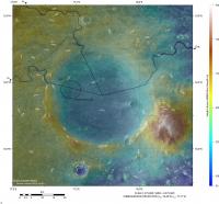
QUOTE (serpens) An interesting abstract from LPSC 2021 which includes... The paper is https://www.hou.usra.edu/meetings/lpsc2021/pdf/1605.pdf QUOTE ARE WE VISITING THE COASTLINES OF MARS? LOAD-CORRECTED PALEO-OCEAN LEVELS AT JEZERO, OXIA PLANUM, AND GALE. R. I. Citron , M. Manga , D. Hemingway and A. Plattner Link to one of papers cited as a reference in the LPSC 2021 paper QUOTE Lithospheric structure and tectonics at Isidis Planitia, Mars J. Andreas Ritzer ∗, Steven A. Hauck, II -2009 https://artscimedia.case.edu/wp-content/upl...icarus_2009.pdf The paper also 'raises' three interesting possibility about Jezro crater. First, Jezro appears to have formed at the shoreline of Mar's highest northern ocean, the basin floor could have been below sea level. Very interesting - were the oceans around long enough to become salty? Second, Crustal deformation associated with the Tharsis bulge & Isidris gravity anomaly appears to have caused the area of Isidris where Jezro crater is to slowly sink almost 2km. Very interesting to ask whether Jezro dropped fast enough that it might have occasionally been under the waves of the northern ocean. A very interesting side effect of the entire Isidris basin slowly dropping is that it might have preserved many layers of shallow water sediments, which is VERY interesting for recreating climate records. A similar situation (slowly sinking land creates a long-lived but always shallow lake which records climate changes) is what is being used to turn Van Hounten cycles into a"Geological Orrey" to determine the parameters of Earth's orbit millions of years ago. Finally, Jezro appears to have remained above the 2nd northern ocean, but water flowing through Jezro ending up in an inland sea filling the Isidris basin.
Attached thumbnail(s)
|
|
|
|
|
|
|
Mar 1 2021, 07:21 PM
Post
#48
|
|
|
Member Group: Members Posts: 248 Joined: 25-February 21 From: Waltham, Massachussetts, U.S.A. Member No.: 8974 |
QUOTE (serpens @ Feb 28 2021, 05:42 PM) This post correlates to Demko's post #392 in the Perseverance Lands In Jezero Crater thread. The direction of sediment flow raised by Tim's assessment has implications for the original size and configuration of the delta and potentially interactions between the two deltas. Yes, agreed. I was more cautious in my interpretation but had the same impression regarding the lower set of foresets, in the shaded, right portion. In fact, I think now that the lower massive bed can be traced all the way to the base of the cliff on the right side where it is exposed again. There is the implication that there were two large scale cycles of progradation followed by regression and possibly erosion which is very typical and commonly observed in terrestrial analogues. -------------------- --
Andreas Plesch, andreasplesch at gmail dot com |
|
|
|
|
Mar 1 2021, 09:19 PM
Post
#49
|
|
|
Senior Member Group: Members Posts: 1044 Joined: 17-February 09 Member No.: 4605 |
Perhaps just coincidence but the pre-Tharsis high stand coverage reflects the extent of olivine/carbonate deposits.
|
|
|
|
|
Mar 3 2021, 06:56 PM
Post
#50
|
|
|
Member Group: Members Posts: 240 Joined: 18-July 06 Member No.: 981 |
 A couple of things interest me here (inset of ESP_068294_1985_RED.jp2 on the HiRISE site - endlessly fascinating image) and was wondering what others think. The released proposed track goes well south of this area yet there is much to explore here a couple of km north of Perseverance and it look like it was quite dynamic geologically in the past. The circular volcano-like feature that I first thought was a mesa that had been separated from the main delta does not appear to be directly associated with the delta. It may have been formed by volcanism or some upwelling of plastic material other than magma. Looking closely at the plain surrounding the feature there is a network of linear fractures and a large apron of material extending to the west. To me this looks like an ice rink that has cracked up under the pressure of something very heavy. Maybe the mass of upwelled material? There is a very picturesque v-shaped bay (It looks like Jaws about to bite Brody) in the delta that looks tantalizing. There seems to be a clearly delineated interface between the upper delta at its base in the western end of the bay (pointy end of the V) and the lower unit. These seem to be distinct units and it would be great to get the supercam and other instruments on both. The southern arm of the bay is formed by an independent linear section of the delta that appears to have separated from the main body of the delta and created a narrow valley leaving a prominent butte at its head. It would be interesting to look at the walls of that valley more closely. There is also a partial crater at the northwestern end and a continuation of the valley beyond with another crater. these craters would give a closer look at the deeper stratification within the delta. Finally something else that fascinates me is the faint arcuate dark feature linking the larger crater to the east of the inset through two smaller craters to its northwest. Maybe just a coincidence, but its an interesting connection between these craters. I hope Percy gets there. Any other thoughts about interesting geologic targets? |
|
|
|
|
Mar 4 2021, 01:08 AM
Post
#51
|
||
|
Member Group: Members Posts: 866 Joined: 15-March 05 From: Santa Cruz, CA Member No.: 196 |
That seeming volcanic cone is quite distinct and intriguing. I recall there was perhaps a flyby of this area in one of Sean's videos in the last year or so. I suspect most of the faint linear features are likely sand dunes, with the larger arcuate feature seen perfectly intersecting through several craters looks like the trail vacuumed clean by a dust devil, it would be interesting to see if older imagery of the same area reveals seasonal differences in this and similar such features in the image. I'm curious if the cone, and perhaps also the similar chaotically eroded conic plateau just below to the left of it in this image that the arc leads to, may post-date delta formation.
[edit] Here I think is the view of that hill from Perseverance R mastcamZ, added in the left view for a parallel stereo to get sense of intervening terrain placement, the pancamZ segment is at far righthand of second teir in EliBonara's panorama linked in serpens' post below
|
|
|
|
|
|
|
Mar 4 2021, 01:53 AM
Post
#52
|
|
|
Senior Member Group: Members Posts: 1044 Joined: 17-February 09 Member No.: 4605 |
The cones are the product of aeolian erosion. There are a number of similar in EliBonora's treatment of the panorama on the Perseverance Lands In Jezero Crater thread post #425 with the link to the image in her flickr album being https://www.flickr.com/photos/lunexit/50995739733/
|
|
|
|
|
Mar 4 2021, 03:34 AM
Post
#53
|
|
|
Member Group: Members Posts: 240 Joined: 18-July 06 Member No.: 981 |
QUOTE (serpens @ Mar 4 2021, 02:53 AM) The cones are the product of aeolian erosion. There are a number of similar in EliBonora's treatment of the panorama on the Perseverance Lands In Jezero Crater thread post #425 with the link to the image in her flickr album being https://www.flickr.com/photos/lunexit/50995739733/ I'm not convinced of that due to the extensive apron of material at the base that has not eroded. Where would the rest of the surrounding material have gone?  Sand cones, yes I get that. But this has a prominent rocky base with no nearby continuation. Appears to just have popped up in the landscape.If it was a volcanic cone it would be a pretty small one. Would be amazing to see it up close. Atomoid, I think you are right The image above is the top of this volkini (mini volcano) I think. Once Percy gets closer to the apron to its north to look over the dune field to the west, it will see the base which is well below Percy's current viewpoint. Looking at the landing images the original proposed track would have depended on landing in the flat area that is now between Percy and the edge of the delta front. Now there are a lot of whipped cream dunes and tricky terrain to traverse to move further southwest. On the other hand, the path to the north looks pretty smooth and clear. The rightmost of the nearby crater twins (Twin E) offers a look at what the lower unit in this region consists of. The heat shield is very nearby that crater and would be a useful target for the materials engineers to get a look at. Then there is a wide open plain to the northwest of that crater leading towards the little volcano and the Jaw Bay I mentioned earlier. Between Percy and Twin E, there is a small outcrop as well that would be a useful first closeup look at the stratigraphy. I tried to find it in the panoramas but had difficulty. It s a very small prominence visible to the northwest of Percy on the way to Twin E. The path to the south looks similarly rough. So my vote is they start moving northward. I am thinking they will want to avoid dune fields at first and prefer flat open areas to test drive on. Once down in the plain at the foot of the delta, the driving should be easy and fast so any particular point will be quite accessible. Getting up on the delta will be quite an interesting exercise though. |
|
|
|
|
Mar 4 2021, 03:54 AM
Post
#54
|
|
|
Junior Member Group: Members Posts: 57 Joined: 20-January 12 From: Florida Member No.: 6317 |
The canyon at lower left in the picture in post #50 is interesting. A long dark valley, then a small crater, then what looks like the continuation of the valley. It reminds me of the pit chains that looks like partially open lava tubes. This one could have been carved by water except it looks black like the lava ones.
|
|
|
|
|
Mar 4 2021, 04:22 AM
Post
#55
|
|
|
Member Group: Members Posts: 240 Joined: 18-July 06 Member No.: 981 |
 Wouldn't that be one crazy vista? Imagine looking up at that dark vertical face from Percy's vantage point at the edge of the dune field by the foot. There is so much here. Caves? Strata in abundance. Toothy dunes arrayed radially. A half pipe at the crest. How tall is this according to the DEM? 50m? |
|
|
|
|
Mar 4 2021, 06:50 AM
Post
#56
|
|||
 Member Group: Members Posts: 714 Joined: 3-January 08 Member No.: 3995 |
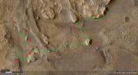
A portion of a possible traverse that would examine some really interesting features:
Points along the way are labeled: 1. First contact along the delta face. 2. Base of cliff below a major channel deposit. 3. Isolated remnant of delta. The images from the rover indicate a spectacular vertical outcrop, possibly displaying sedimentary structures of various kinds. 4. Possibly traversable section of sediments, which may include lake beds. 5. Very nice outcrop of possible lake deposits. 6. Another butte to explore on the way up to the delta's surface. 7. Strata outcrop along the entire way to the top. Stop 5 up close:
This is just utterly amazing. |
||
|
|
|
||
|
Mar 4 2021, 06:58 AM
Post
#57
|
||
|
Member Group: Members Posts: 714 Joined: 3-January 08 Member No.: 3995 |
Would also like to examine some of these up close:
I'm guessing clastic dikes with alternately expanding and subsiding material. |
|
|
|
|
|
|
Mar 4 2021, 04:36 PM
Post
#58
|
|
|
Member Group: Members Posts: 684 Joined: 24-July 15 Member No.: 7619 |
QUOTE (atomoid @ Mar 4 2021, 01:08 AM) Here I think is the view of that hill from Perseverance R, added in the left view for a parallel stereo to get sense of intervening terrain placement, the pancamZ segment is at far righthand of second teir in EliBonara's panorama linked in serpens' post below Excellent work - That large image size is giving my eye-crossing muscles a bit of a workout though... One trick for anybody learning to see cross-eyed is to place you palm vertically in front of your nose. (Something I learned from viewing molecular bio papers that showed cross-eyed protein structures) |
|
|
|
|
Mar 4 2021, 04:51 PM
Post
#59
|
||
|
Member Group: Members Posts: 684 Joined: 24-July 15 Member No.: 7619 |
QUOTE (Gladstoner @ Mar 4 2021, 06:58 AM) Would also like to examine some of these up close:
I'm guessing clastic dikes with alternately expanding and subsiding material. Could also be good old normal jointing / faulting and later mineralization. The Isidris region may have had a 2 kilometer elevation drop due to slow crustal deformation from the weight of Tharsis plateau & the Isidris gravity anomaly/deposition. When you try and stretch rocks, they break into joints at fairly regular intervals, based on the material strength, so that MAY be a clue to whether the basement stone is weak mudstone or much stronger basalt/granite. |
|
|
|
|
|
|
Mar 4 2021, 08:31 PM
Post
#60
|
|
|
Forum Contributor Group: Members Posts: 1372 Joined: 8-February 04 From: North East Florida, USA. Member No.: 11 |
QUOTE (Gladstoner @ Mar 4 2021, 06:50 AM) A portion of a possible traverse that would examine some really interesting features:.. Looks like a lot of sand traps to me... |
|
|
|
|
Mar 4 2021, 09:55 PM
Post
#61
|
|
|
Member Group: Members Posts: 706 Joined: 22-April 05 Member No.: 351 |
QUOTE (Gladstoner @ Mar 3 2021, 10:50 PM) A portion of a possible traverse that would examine some really interesting features: A stated difference between Curiosity and Perseverance is that the former's mission is to explore the diversity of features - i.e., drive to and examine as many interesting features as possible. Percy's mission is to collect a full set of Jezero samples (~15) within one Martian year. In presentations, managers have said that there will be less time exploring interesting features. -------------------- |
|
|
|
|
Mar 4 2021, 10:10 PM
Post
#62
|
||
|
Member Group: Members Posts: 866 Joined: 15-March 05 From: Santa Cruz, CA Member No.: 196 |
...That large image size is giving my eye-crossing muscles a bit of a workout though...[/quote]
that was just a parellel view, though thats more comfortable to the eye muscles (you just fool your eyes to splay as if to look into the distance past the image) it limits the image width to the distance between your eyes as dependent upon the viewing screen size (unless you fiddle with the zoom of your browser window to compensate). Below is the crosseye version, i left it much larger since its a far easier feat to cross than to splay the eyes..
|
|
|
|
|
|
|
Mar 4 2021, 10:13 PM
Post
#63
|
|
 Senior Member Group: Admin Posts: 4763 Joined: 15-March 05 From: Glendale, AZ Member No.: 197 |
QUOTE (Steve5304 @ Feb 27 2021, 09:11 PM) If thats Vesicular basalt then isbit safe to say we havent landed in an area that was aquactic Like Hawaii? -------------------- If Occam had heard my theory, things would be very different now.
|
|
|
|
|
Mar 4 2021, 10:55 PM
Post
#64
|
|
|
Senior Member Group: Members Posts: 1044 Joined: 17-February 09 Member No.: 4605 |
vjkane, Perseverance has four primary mission objectives which contribute to the key science goals of NASA's total Mars exploration program. The program goals are:
Determine if Mars Ever Supported Life. Understand the Processes and History of Climate on Mars. Understand the Origin and Evolution of Mars. Prepare for Human Exploration. Primary mission objectives are: Explore an astrobiologically relevant ancient environment on Mars to decipher its geological processes and history, including the assessment of past habitability. Assess the biosignature preservation potential and search for potential biosignatures. Demonstrate significant technical progress towards the future return of scientifically selected, well-documented samples to Earth. Provide an opportunity for contributed Human Exploration and Operations Mission Directorate or Space Technology Program participation. The first two primary objectives are not incompatible with sample collection and caching and the samples would be harvested from 'interesting features' with solid geological/geochemical indications. But I suspect that a baseline path is being prepared based on the touchdown location and that they will want to move off the mafic floor unit as fast as possible, possibly collecting an igneous sample along the way. |
|
|
|
|
Mar 5 2021, 12:24 AM
Post
#65
|
|
|
Member Group: Members Posts: 706 Joined: 22-April 05 Member No.: 351 |
QUOTE (serpens @ Mar 4 2021, 02:55 PM) vjkane, Perseverance has four primary mission objectives which contribute to the key science goals of NASA's total Mars exploration program. The program goals are: Determine if Mars Ever Supported Life. Understand the Processes and History of Climate on Mars. Understand the Origin and Evolution of Mars. Prepare for Human Exploration. Primary mission objectives are: Explore an astrobiologically relevant ancient environment on Mars to decipher its geological processes and history, including the assessment of past habitability. Assess the biosignature preservation potential and search for potential biosignatures. Demonstrate significant technical progress towards the future return of scientifically selected, well-documented samples to Earth. Provide an opportunity for contributed Human Exploration and Operations Mission Directorate or Space Technology Program participation. The first two primary objectives are not incompatible with sample collection and caching and the samples would be harvested from 'interesting features' with solid geological/geochemical indications. But I suspect that a baseline path is being prepared based on the touchdown location and that they will want to move off the mafic floor unit as fast as possible, possibly collecting an igneous sample along the way. Serpens, you are right that exploration is compatible with all those goals. But while Curiosity has taken years to get to where it has, Percy is supposed to make the Jezero crater rim in about one Martian year. That just leaves less time to smell the flowers or zap the rocks. And then if I remember right, about another Martian year to reach the Midway area, about another year to collect samples there, and then the MSR lander is scheduled to arrive. -------------------- |
|
|
|
|
Mar 5 2021, 12:47 AM
Post
#66
|
|
|
Senior Member Group: Members Posts: 1044 Joined: 17-February 09 Member No.: 4605 |
I thought the revised schedule was for launch of the retrieval mission in 2028 with the return of the samples in 2033?
|
|
|
|
|
Mar 5 2021, 02:04 AM
Post
#67
|
|
|
Member Group: Members Posts: 706 Joined: 22-April 05 Member No.: 351 |
QUOTE (serpens @ Mar 4 2021, 04:47 PM) I thought the revised schedule was for launch of the retrieval mission in 2028 with the return of the samples in 2033? A review team suggested planning to delay the launch but nasa is still going with 2026. Between you and me Id bet on 2028, but 2026 has 2028 as a backup. Theres no backup to 2028. -------------------- |
|
|
|
|
Mar 5 2021, 03:45 AM
Post
#68
|
|
|
Senior Member Group: Members Posts: 2085 Joined: 13-February 10 From: Ontario Member No.: 5221 |
One of the papers I read (can't find it now) implied that speed is not about finishing before the retrieval mission arrives, but placing enough caches down in case something catastrophic happens years down the road, rendering any samples still inside Perseverance irretrievable. The fetch rover's job is difficult enough as is; no need to make it harder.
|
|
|
|
|
Mar 5 2021, 05:28 AM
Post
#69
|
|
|
Member Group: Members Posts: 706 Joined: 22-April 05 Member No.: 351 |
QUOTE (Explorer1 @ Mar 4 2021, 07:45 PM) One of the papers I read (can't find it now) implied that speed is not about finishing before the retrieval mission arrives, but placing enough caches down in case something catastrophic happens years down the road, rendering any samples still inside Perseverance irretrievable. The fetch rover's job is difficult enough as is; no need to make it harder. The current plan is to double collect in Jezero. Half the collection is left on the rim in case Percy has a catastrophic failure on the way to Midway. Ideally, Percy collects new samples in Midway to supplement those retained from Jezero. There doesn't seem to be a consensus yet on how to deal with samples carried from Jezero or collected in Midway. If they are retained by Percy and it has a catastrophic failure, the fetch rover can't remove them from Percy. If Percy deposits all of them in a cache at Midway and the fetch rover fails, Percy can't pick them up to deliver them to the MAV. -------------------- |
|
|
|
|
Mar 5 2021, 07:25 AM
Post
#70
|
|
|
Forum Contributor Group: Members Posts: 1372 Joined: 8-February 04 From: North East Florida, USA. Member No.: 11 |
QUOTE (vjkane @ Mar 5 2021, 05:28 AM) ...Percy can't pick them up to deliver them to the MAV. I was under the impression once Percy drops the tubes on the ground it cannot pick them back up. |
|
|
|
|
Mar 5 2021, 10:06 AM
Post
#71
|
|
|
Senior Member Group: Members Posts: 2530 Joined: 20-April 05 Member No.: 321 |
One solution to this would be to fill about 3/4 (~24) of the sample tubes on the way up to the rim. At the top of the rim, drop ~16 of them, representing the whole trek up the delta, on the ground, and keep ~8 that also represent the trek up the delta. Then pick up ~8 more on the crater rim, and when that is complete, drop all ~16 in one spot.
That leaves you with ~16 representing the delta in one place and ~16 representing both the delta and the crater rim in another place. The return can choose which group of 16 to retrieve. If there were any failure in the return, there's another group of ~16 for a second try. If Perseverance failed after reaching the crater rim, there would be the first set of ~16 for a first and only retrieval attempt. |
|
|
|
|
Mar 5 2021, 12:08 PM
Post
#72
|
|
|
Member Group: Members Posts: 684 Joined: 24-July 15 Member No.: 7619 |

|
|
|
|
|
Mar 5 2021, 12:12 PM
Post
#73
|
|
|
Member Group: Members Posts: 684 Joined: 24-July 15 Member No.: 7619 |
QUOTE (vjkane @ Mar 5 2021, 05:28 AM) If they are retained by Percy and it has a catastrophic failure, the fetch rover can't remove them from Percy. Let me introduce you to 1998 Jeremy Clarkson... https://youtu.be/X7USYfgvIkU?t=28
|
|
|
|
|
Mar 5 2021, 02:23 PM
Post
#74
|
|||
|
Member Group: Members Posts: 706 Joined: 22-April 05 Member No.: 351 |
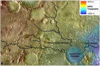
QUOTE (JRehling @ Mar 5 2021, 02:06 AM) One solution to this would be to fill about 3/4 (~24) of the sample tubes on the way up to the rim. At the top of the rim, drop ~16 of them, representing the whole trek up the delta, on the ground, and keep ~8 that also represent the trek up the delta. Then pick up ~8 more on the crater rim, and when that is complete, drop all ~16 in one spot. That leaves you with ~16 representing the delta in one place and ~16 representing both the delta and the crater rim in another place. The return can choose which group of 16 to retrieve. If there were any failure in the return, there's another group of ~16 for a second try. If Perseverance failed after reaching the crater rim, there would be the first set of ~16 for a first and only retrieval attempt. Phil Stooke at NASAspaceflight.com posted links to presentations from a recent sampling strategy workshop. Extremely interesting with lots of details on the notional traverses, notional sampling plan, and notional caching strategy Link to Phil's post First set of slides Second set of slides Third set of slides These slides are from those presentations and represent a notional sampling strategy.
Attached thumbnail(s)
-------------------- |
||
|
|
|
||
|
Mar 5 2021, 04:23 PM
Post
#75
|
|
|
Senior Member Group: Members Posts: 2530 Joined: 20-April 05 Member No.: 321 |
Thanks for the full background, Van.
It was this pair of adjacent statements from the first set of slides: "Perseverance is likely to create two depots, only one of which will likely be returned. - notionally, one in Jezero Crater and one somewhere on Nili Planum. The Science Team believes that the only way to have the complete collection in a second depot is to 'double sample' critical (all?) samples prior to first depot deployment." that I was summarizing with my comment in terms of ~16s and ~8s. |
|
|
|
|
Mar 5 2021, 06:59 PM
Post
#76
|
|
|
Member Group: Members Posts: 248 Joined: 25-February 21 From: Waltham, Massachussetts, U.S.A. Member No.: 8974 |
QUOTE (vjkane @ Mar 5 2021, 09:23 AM) Phil Stooke at NASAspaceflight.com posted links to presentations from a recent sampling strategy workshop. Extremely interesting with lots of details on the notional traverses, notional sampling plan, and notional caching strategy Link to Phil's post First set of slides Second set of slides Third set of slides These slides are from those presentations and represent a notional sampling strategy. Thanks, these slides provide a good summary of what I take is the current understanding of the crater and surroundings in terms of geology, traversability, and relevance to mission goals. It was the first time for me to delve a bit deeper into these planning steps. I have to say, it was surprising to me how much emphasis there is on getting out of the crater even given that it is clearly stated that the delta and the crater lake basin are the primary target. Why not really focus on that primary target ? I understand that the more diverse geology outside of the crater (Nili Planum) is tempting and that it could be explored but the criteria for not leaving the crater is either serious rover dysfunction or extremely exciting discoveries on the way (what ? a fossil ?). That leaves room for only one traversal up and along the delta. In effect, it gives the delta and crater interior the same weight as Nili Planum which does not sit quite right. So I think it will be important to make this one delta traverse count perhaps by attempting to cover all sides of the (remaining) delta. One could even argue one should stay in the delta until there is a sense of exciting discoveries, and only then leave, rather than leaving by default. Another impression I had that there is rather high confidence that it is possible to plan a detailed traverse based on current remote sensing data. My very limited experience looking in detail at HiRISE imagery around the landing site (and even EDL imagery) and comparing it with rover imaging on the ground would make me much less confident to do such planning much in advance. The rover is only 3m or so, eg. a few pixels in these images. In other words, it will be critical to use on the ground imagery as it becomes available, with a willingness to revise existing plans freely. This seems perhaps obvious but with all the planning investment there may be a degree of inertia. Considering this, I think there should be a lot of, almost exclusive emphasis on getting to and sampling the sediments about which we can know with a high degree of confidence that (a lot of) water was present. Apart from the potential for life, their composition is an indirect sample of the watershed area (at the time) which often leads to strong conclusions about geologic evolution. Imagine finding a conglomerate bed. The clasts could be dated. -------------------- --
Andreas Plesch, andreasplesch at gmail dot com |
|
|
|
|
Mar 5 2021, 08:44 PM
Post
#77
|
|
|
Senior Member Group: Members Posts: 2530 Joined: 20-April 05 Member No.: 321 |
I share the subjective feeling that Andreas indicates, that the relative emphasis on the pre-lake materials may seem a bit surprising, but I think that what gives it relevance is the extremely compressed nature of martian history, where the time since the lake ceased to exist until now is extremely long compared to the time from the origin of the primordial martian crust to the creation of (and even end of) the lake. Given the model of an early warmer, wetter Mars that ceased to exist a long time ago, the formation of the crust and the crater is part of the same timeframe as the lake, and if we're interested in the evolution of the martian environment in which the lake formed, it would be very unfortunate to get an excellent characterization of the middle of the lake era but miss the opportunity to characterize the start of it, as represented in materials only ~1 km away.
|
|
|
|
|
Mar 5 2021, 11:04 PM
Post
#78
|
|
|
Senior Member Group: Members Posts: 1044 Joined: 17-February 09 Member No.: 4605 |
I suspect that as with Curiosity there will be significant deviations from the planned path over time. There are also unknown variables to consider such as Rover health and the potential for a schedule delay with respect to the retrieval mission, as was the case for Curiosity and the Exomars program. A healthy Perseverance and a forecast 2 year schedule delay could well give rise to some competitive discussion on science targets. As Robert Burns penned, The best laid schemes o Mice an Men Gang aft agley.
|
|
|
|
|
Mar 6 2021, 12:56 AM
Post
#79
|
|
|
Member Group: Members Posts: 706 Joined: 22-April 05 Member No.: 351 |
QUOTE (Andreas Plesch @ Mar 5 2021, 10:59 AM) Thanks, these slides provide a good summary of what I take is the current understanding of the crater and surroundings in terms of geology, traversability, and relevance to mission goals. It was the first time for me to delve a bit deeper into these planning steps. I have to say, it was surprising to me how much emphasis there is on getting out of the crater even given that it is clearly stated that the delta and the crater lake basin are the primary target. Why not really focus on that primary target? ... Another impression I had that there is rather high confidence that it is possible to plan a detailed traverse based on current remote sensing data. My very limited experience looking in detail at HiRISE imagery around the landing site (and even EDL imagery) and comparing it with rover imaging on the ground would make me much less confident to do such planning much in advance. The rover is only 3m or so, eg. a few pixels in these images. In other words, it will be critical to use on the ground imagery as it becomes available, with a willingness to revise existing plans freely. This seems perhaps obvious but with all the planning investment there may be a degree of inertia. Considering this, I think there should be a lot of, almost exclusive emphasis on getting to and sampling the sediments about which we can know with a high degree of confidence that (a lot of) water was present. Apart from the potential for life, their composition is an indirect sample of the watershed area (at the time) which often leads to strong conclusions about geologic evolution. Imagine finding a conglomerate bed. The clasts could be dated. From presentations I watched several years ago, the focus was always to get a good sample of Jezero from the crater floor to rim in the primary mission lasting one Martian year. Any extended mission is gravy. A couple of thoughts on why to leave. The Great Cosmic God smiled on us and the top two places to sample Mars (as selected through a series of workshops bringing in much of the Mars science community) happen to be within driving distance. As I recall, Jezero won the vote of the workshop participants, but not by much. Not only does Midway likely contain a geologic record of key events, several of the proposed sampling sites could be locations of significant astrobiological interest. The science community *really* wants sample from both areas. As for planning the traverse, I have experience with similar products to what I expect the mission planners have. From stereo HiRISE imaging, they likely have a highly accurate 1 m (or slightly better) digital terrain model. They also can tell a great deal about the likely surface of each location from both direct photo interpretation and from texture analysis of variance among adjacent pixels. They have been using these products to plan Curiosity's traverse for years now. -------------------- |
|
|
|
|
Mar 6 2021, 02:01 AM
Post
#80
|
|
|
Member Group: Members Posts: 248 Joined: 25-February 21 From: Waltham, Massachussetts, U.S.A. Member No.: 8974 |
QUOTE (vjkane @ Mar 5 2021, 07:56 PM) From presentations I watched several years ago, the focus was always to get a good sample of Jezero from the crater floor to rim in the primary mission lasting one Martian year. Any extended mission is gravy. A couple of thoughts on why to leave. The Great Cosmic God smiled on us and the top two places to sample Mars (as selected through a series of workshops bringing in much of the Mars science community) happen to be within driving distance. As I recall, Jezero won the vote of the workshop participants, but not by much. Not only does Midway likely contain a geologic record of key events, several of the proposed sampling sites could be locations of significant astrobiological interest. The science community *really* wants sample from both areas. As for planning the traverse, I have experience with similar products to what I expect the mission planners have. From stereo HiRISE imaging, they likely have a highly accurate 1 m (or slightly better) digital terrain model. They also can tell a great deal about the likely surface of each location from both direct photo interpretation and from texture analysis of variance among adjacent pixels. They have been using these products to plan Curiosity's traverse for years now. Thanks for the background. Concerning the planning products, of course they are very valuable for considering all options. I was just impressed how every twist and turn was shown on some of planning maps. Now, the map presented today seems to go out of the crater on another route, eg. straight through the main inlet, for now. Looking at the slides, I did start to think that there are probably strong factions in the community for both the Delta and also Midland. In that case the planning discussion material makes more sense. Thinking ahead it is somewhat problematic that the expected lifetime (1-2 years) of the mission is so conservative, in light of the success of previous missions. It will be impossible to argue to go back into the crater once the rover left it. -------------------- --
Andreas Plesch, andreasplesch at gmail dot com |
|
|
|
|
Mar 6 2021, 02:02 PM
Post
#81
|
|
|
Member Group: Members Posts: 706 Joined: 22-April 05 Member No.: 351 |
QUOTE (Andreas Plesch @ Mar 5 2021, 06:01 PM) ...Thinking ahead it is somewhat problematic that the expected lifetime (1-2 years) of the mission is so conservative, in light of the success of previous missions. It will be impossible to argue to go back into the crater once the rover left it. Everyone hopes and probably expects that Percy will have a long life and will sample both Jezero and Midway. However, rovers/spacecraft do break, and any operations past the first Martian year also require that NASA approve an extended mission and that is funded. So the managers and science team want to make sure that the base mission requirements are met in that first year. -------------------- |
|
|
|
|
Mar 6 2021, 03:13 PM
Post
#82
|
||
|
Member Group: Members Posts: 684 Joined: 24-July 15 Member No.: 7619 |
I found the timeline for Jezro in the press package links very interesting
- especially when overlaid with the Arabia and Dueteronilus shoreline information. - rough ages gleaned from - QUOTE Timing of oceans on Mars from shoreline deformation Robert I. Citron, Michael Manga1,, Douglas J. Hemingway https://escholarship.org/content/qt810840x9...4370aa39e91.pdf (would be VERY interested to hear other ranges of dating) So, here\'s a guesstimate of adding the Martian oceans to the mix- 1) 4BY and the Martian northern ocean has a stable border at the Arabia shoreline. 2) 3.95 BY and Isidris impact creates a shallow bay, future location of Jezro is underwater. 3) 3.95 & 3.85 BY and regional olivine- carbonates form, (possibly in a shallow bay?) 4) 3.75 BY and Jezro valley drainage system established, (when was the crater-forming impact?) If Jezro was an shallow ocean crater like the Chesapeake Bay crater,  it could have dominated the surface drainage networks and the local groundwater / saltwater aquifer boundary. 5) 3.7-3.6(?) BY and Tharsis volcanism deforms crust and raises Jezro crater and Isidris bay ~2km. 6) Concurrent with Tharsis, the northern ocean retreats and stabilizes at the Dueteronilus shoreline, leaving Isidris Bay as Lake Isidris. 7) Mafic crater floor emplaced, could be during or after Lake Isidris dries up.
Attached thumbnail(s)
|
|
|
|
|
|
|
Mar 6 2021, 10:59 PM
Post
#83
|
|
 Member Group: Members Posts: 153 Joined: 8-February 04 From: Phoenix, AZ USA Member No.: 9 |
Im not sure the emphasis is on the pre-lake deposits as much as it is in the initial, earliest lake deposits that are directly above them. The lowest, most distal lacustrine clinothem facies (toesets) will be the finest grained and most likely to concentrate less dense organic material. If a location can be found that is beyond the limit of coarse grained (sand?) deposition, that records only the distal parts of several clinothem cycles, several toeset samples could be acquired. Otherwise, sampling will have to concentrate on the lower parts of the coarsening/thickening-upward successions, which unfortunately get mantled by recent eolian deposits and talus.
-------------------- Tim Demko
BioLink site |
|
|
|
|
Mar 7 2021, 12:29 AM
Post
#84
|
|
|
Senior Member Group: Members Posts: 2530 Joined: 20-April 05 Member No.: 321 |
Good information, tdemko.
In this case, it seems like getting as much of the timeline as possible is a priority, and that no one best sample could possibly give us the information we're looking for. Whatever warm, wet epoch Mars had, it was relatively short, and what we hope for is the ability to see how it evolved. The final chapter of the book might be the most interesting, but the whole story will be very interesting. |
|
|
|
|
Mar 7 2021, 11:31 AM
Post
#85
|
|
|
Merciless Robot Group: Admin Posts: 8783 Joined: 8-December 05 From: Los Angeles Member No.: 602 |
Should I just change the name of this thread to "The Great Percy Debate", subtitled "Why UMSF Admins Drink So Much"...?
 EDIT: Created a dedicated thread for the name discussion. 7 posts moved. Onward. -------------------- A few will take this knowledge and use this power of a dream realized as a force for change, an impetus for further discovery to make less ancient dreams real.
|
|
|
|
|
Mar 8 2021, 12:39 AM
Post
#86
|
|||
|
Senior Member Group: Members Posts: 1044 Joined: 17-February 09 Member No.: 4605 |
QUOTE (Gladstoner @ Mar 4 2021, 06:58 AM) Would also like to examine some of these up close:
I'm guessing clastic dikes with alternately expanding and subsiding material. I assume that this has been addressed in erudite analyses although I haven't been able to locate any, but with respect to the source of the MFU how confident are we that the anomalously high mountain with the crater on top, in the South just outside the rim (opposite the delta) is not the remnant of a volcano and caldera. The presence of such would raise the probability of flows from weak points in the crater floor and the presence of dikes.
Attached thumbnail(s)
|
||
|
|
|
||
|
Mar 8 2021, 02:04 PM
Post
#87
|
|
|
Member Group: Members Posts: 153 Joined: 8-February 04 From: Phoenix, AZ USA Member No.: 9 |
Not sure if the question about experimental basin fills was in this thread, but here is a nice animation by Zoltan Sylvester of the Jurassic Tank/XES experiment in 2002:
https://twitter.com/zzsylvester/status/1368688046435106826 Note the clinothems, their timing, and stacking patterns, especially in relation to the water/base level in in the experiment. Here is a nice paper describing the facilities, their capabilities, and some more visualizations of results. https://www.researchgate.net/publication/24...al_Stratigraphy I used to do this for a living, so, if there is interest, I can provide more information on physical and numerical modeling of deltas. -------------------- Tim Demko
BioLink site |
|
|
|
|
Mar 8 2021, 09:02 PM
Post
#88
|
|
|
Member Group: Members Posts: 248 Joined: 25-February 21 From: Waltham, Massachussetts, U.S.A. Member No.: 8974 |
The source of the sediments in the delta
The (main?) inlet through the crater wall into the crater basin is well preserved. It is possible to trace back the main stream flowing into the basin about 100 miles to the west which is further than I thought:   Esri has a nice ctx mosaic map at https://arcg.is/1Wumea to zoom into. It is possible that evidence of flow further upstream was eroded but there are only very faint indications for that. From a terrestrial perspective it is curious that there are no obvious tributaries, indicating perhaps a locally or regionally arid area. But in the potential catchment area upstream there is also a lack of a network collecting from a larger source. Does that hint at very episodic but large volume flow ? Completely speculating, the periglacial in advance of glaciation margins is often arid. Is glaciation being considered physically at all consistent with atmospheric and aquatic conditions at the time ? Here is a rough elevation profile from the basin floor to the catchment area:  The relief is more than 2km today which is about a 1.5% slope on average, and perhaps enough of a change to get into a glacial climate in the highlands. Another first order observation is the linearity of the west to east flow direction, with larger scale meandering superimposed. That would require a consistent but small slope across the 100 mile stretch, and limited time for flow to avoid generating a more equilibrated profile. In deed, the profile today is still at a pretty constant slope but a careful measurement along the base of the stream may be needed. Sediments in the delta would seem to need to be sourced from rather close to the course of the stream. Let's take a look at the geologic map. Last but not least, there is also a (secondary?) inlet at the northern rim of Jezero which can be traced into the more mountainous region south of Hargraves crater which seems like a more promising area for catching and collecting precipitation. It looks like it is possible to map more of a network of streams and potential crater lakes there. Around that second inlet there may be sediments as well (edit: closer inspection does not look promising), and their composition may contrast with those from the delta given the differences in their expected provenance. Nevermind, the second, northern inlet is not a mission target, other areas do seem more promising. -------------------- --
Andreas Plesch, andreasplesch at gmail dot com |
|
|
|
|
Mar 8 2021, 11:58 PM
Post
#89
|
|
|
Member Group: Members Posts: 684 Joined: 24-July 15 Member No.: 7619 |
QUOTE (serpens @ Mar 8 2021, 01:39 AM) I assume that this has been addressed in erudite analyses although I haven't been able to locate any, but with respect to the source of the MFU how confident are we that the anomalously high mountain with the crater on top, in the South just outside the rim (opposite the delta) is not the remnant of a volcano and caldera. The presence of such would raise the probability of flows from weak points in the crater floor and the presence of dikes. The "crustal deformation" paper upthread mentions an mass-concentration under Isidris basin, which could be upwellings of denser crust. |
|
|
|
|
Mar 9 2021, 12:27 AM
Post
#90
|
|
|
Senior Member Group: Members Posts: 2530 Joined: 20-April 05 Member No.: 321 |
With both respect and gratitude for the expertise of the terrestrial geologists, would the different geophysical properties on Mars adjust some of the parameters in a predictable way. E.g., at 0.38g, would the slower flow downslope flow of rivers at a given slope change the morphology in predictable ways?
|
|
|
|
|
Mar 9 2021, 01:17 AM
Post
#91
|
||
|
Senior Member Group: Members Posts: 1044 Joined: 17-February 09 Member No.: 4605 |
Andreas, despite erosion there are obvious remnants of tributaries to the main river. The image below is taken from https://www.sciencedirect.com/science/artic...03206331200044X
Attached thumbnail(s)
|
|
|
|
|
|
|
Mar 9 2021, 02:29 AM
Post
#92
|
|
|
Member Group: Members Posts: 248 Joined: 25-February 21 From: Waltham, Massachussetts, U.S.A. Member No.: 8974 |
There are sedimentologists specializing in landscape evolution and numerical modeling, see for example https://agupubs.onlinelibrary.wiley.com/doi...1002/jgrf.20031 . Consequently, there are a large number of models, based on diffusion or advection concepts. Unfortunately, I am not such a modeler and do not have that insight. My inclination would be to treat lower gravity similar to a change in slope both acting on the erosional effect at the river base in similar ways. Slope is just one parameter besides flow rate, sediment load or potentially tectonic uplift or subsidence.
With that in mind I would expect that 0.38g would require a much steeper slope for a stream to develop similar erosional characteristics, other parameters being equal (which would be difficult to establish). The 2km relief over 100km intuitively feels rather steep and it should be possible to find longitudinal river profiles of similar length, for a direct comparison. A main difference is that the profile does not look like a textbook river profile on earth which has a steep initial gradient, an intermediate section, and a very gentle final gradient before entering a base line (a lake or ocean) which is considered an equilibrium profile where erosion at the source and aggradation at the sink are in balance. I suspect that there have been attempts to understand such profiles on Mars, after the idea of an early wet history was getting (more?) widely accepted. Looking more closely along the stream, there are what could be rather short tributaries, and perhaps drainage from the Hargraves crater region to the north. Proposing a secondary inlet at the northern crater rim clearly requires some interpretation since it would be not very well preserved. I do think there are markers of channeling and meandering further upstream which seem to connect to it. [edit] ah Thanks serpens, yes that is what I see as well. It is just not much of a system of tributaries. -------------------- --
Andreas Plesch, andreasplesch at gmail dot com |
|
|
|
|
Mar 9 2021, 02:43 AM
Post
#93
|
|
|
Member Group: Members Posts: 153 Joined: 8-February 04 From: Phoenix, AZ USA Member No.: 9 |
QUOTE (JRehling @ Mar 8 2021, 07:27 PM) With both respect and gratitude for the expertise of the terrestrial geologists, would the different geophysical properties on Mars adjust some of the parameters in a predictable way. E.g., at 0.38g, would the slower flow downslope flow of rivers at a given slope change the morphology in predictable ways? Nice recent papers on the subject: https://pubs.geoscienceworld.org/gsa/geolog...J8C5xSG4mS7RX60 https://www.sciencedirect.com/science/artic...019103520305716 Summary: Yes, we should expect differences, but they may be subtle. Morphodynamic comparisons of Martian and terrestrial channels, both fluvial and submarine, show the same geometric relationships. Bedforms may form at different shear stress - grain size conditions and there will be differences in bedload versus suspended load transport. The Amy and Dorrell paper does predict that the upper reaches of graded suspended load rivers in less than earth gravity will have gentler slopes, as Andreas observed in his long profile. -------------------- Tim Demko
BioLink site |
|
|
|
|
Mar 9 2021, 02:54 AM
Post
#94
|
|
|
Member Group: Members Posts: 248 Joined: 25-February 21 From: Waltham, Massachussetts, U.S.A. Member No.: 8974 |
I find myself agreeing with much of what the abstract says:
https://doi.org/10.1016/j.pss.2012.02.003 But I would be less certain about not having cycles of deposition, and erosion, or perhaps completely drying out the Lake. We already saw at least two cycles of progradation and regression on top of each other, with the benefit of ground views. The sudden end of the Lake, leaving the proximal part of the delta largely intact and unincised is just the final act of potentially millions of years of depositional history, as the authors suggest. -------------------- --
Andreas Plesch, andreasplesch at gmail dot com |
|
|
|
|
Mar 9 2021, 10:20 AM
Post
#95
|
|
|
Member Group: Members Posts: 240 Joined: 18-July 06 Member No.: 981 |
Do we have any insight as to why the small deltaic remnants exist at such a distance from the main delta front? Did they move somehow from where they were emplaced? What could cause the significant and remarkably complete (scoured clean down to the top of the underlying unit) erosion of the delta material and what saved these remnants which are presumably analogues of the main delta. Could they have been islands in the lake?
The interesting one (to me) to the north looks much like a volcano from above with no clear evidence of stratification. There are some concentric dust rings that might relate to strata but its hard to be sure. Getting a close look at that might yield some useful information about the delta and the erosional processes that have sculpted the front. |
|
|
|
|
Mar 9 2021, 11:22 AM
Post
#96
|
|
|
Forum Contributor Group: Members Posts: 1372 Joined: 8-February 04 From: North East Florida, USA. Member No.: 11 |
QUOTE (MarkL @ Mar 9 2021, 10:20 AM) Do we have any insight as to why the small deltaic remnants exist at such a distance from the main delta front? Did they move somehow from where they were emplaced? What could cause the significant and remarkably complete (scoured clean down to the top of the underlying unit) erosion of the delta material and what saved these remnants which are presumably analogues of the main delta. Could they have been islands in the lake? Likely chance and the vagaries of the wind over billions of years. |
|
|
|
|
Mar 9 2021, 12:14 PM
Post
#97
|
||
|
Member Group: Members Posts: 684 Joined: 24-July 15 Member No.: 7619 |
QUOTE Do we have any insight as to why the small deltaic remnants exist at such a distance from the main delta front? Did they move somehow from where they were emplaced? What could cause the significant and remarkably complete (scoured clean down to the top of the underlying unit) erosion of the delta material and what saved these remnants which are presumably analogues of the main delta. Could they have been islands in the lake? The interesting one (to me) to the north looks much like a volcano from above with no clear evidence of stratification. There are some concentric dust rings that might relate to strata but it’s hard to be sure. Getting a close look at that might yield some useful information about the delta and the erosional processes that have sculpted the front. Remember the entire area may have dropped 2 km and tilted during the millions of years of Tharsis volcanism. Then is probably tilted again during the Isidris basin volcanism. During the era of the Arabia Ocean Jezro could have been a coastal crater partially below sea level. Tharsis volcanism would have dropped Jezro up to 2 km below the Arabia Ocean sea level (if that ocean was still there). During the later era of the Deuteronilus Ocean, Jezro could have been an inland lake feeding into a great lake in Isidris. QUOTE ARE WE VISITING THE COASTLINES OF MARS? LOAD-CORRECTED PALEO-OCEAN LEVELS AT
JEZERO, OXIA PLANUM, AND GALE. R. I. Citron , M. Manga , D. Hemingway and A. Plattner https://www.hou.usra.edu/meetings/lpsc2021/pdf/1605.pdf
Attached thumbnail(s)
|
|
|
|
|
|
|
Mar 9 2021, 02:36 PM
Post
#98
|
|
|
Senior Member Group: Members Posts: 1044 Joined: 17-February 09 Member No.: 4605 |
QUOTE (Andreas Plesch @ Mar 9 2021, 03:29 AM) ....It is just not much of a system of tributaries. While the catchment as it stands can be reasonably constrained, as HSchirmer alludes to the area has been subject to tectonic activity, cratering and erosion that makes the accurate assessment of the ancient drainage area and tributary flows challenging to say the least. While there are traces of the tributaries much has been erased. As I understand it the mineralogy of the Northern and Southern deltas vary, reflecting the mineralogy of the two separate catchment areas. All in all it is a pretty impressive drainage area which I suspect would have hosted an extensive tributary network. |
|
|
|
|
Mar 9 2021, 03:08 PM
Post
#99
|
|
|
Member Group: Members Posts: 248 Joined: 25-February 21 From: Waltham, Massachussetts, U.S.A. Member No.: 8974 |
QUOTE (serpens @ Mar 9 2021, 09:36 AM) While the catchment as it stands can be reasonably constrained, as HSchirmer alludes to the area has been subject to tectonic activity, cratering and erosion that makes the accurate assessment of the ancient drainage area and tributary flows challenging to say the least. While there are traces of the tributaries much has been erased. As I understand it the mineralogy of the Northern and Southern deltas vary, reflecting the mineralogy of the two separate catchment areas. All in all it is a pretty impressive drainage area which I suspect would have hosted an extensive tributary network. Undoubtedly, there has been substantial vertical tectonics (with some extensional rifting) as there is so much geologic time available. Nevertheless, today the crater floor is essentially horizontal and the main stream bed is well preserved, up to a 100 miles back. So the base assumption would be that first order tributaries would be preserved to a similar degree. I agree that together the Northern and Southern deltas were supplied from a large catchment. Since the main stream to me looks relatively starved to the west and south, perhaps at times there was major supply from the north. -------------------- --
Andreas Plesch, andreasplesch at gmail dot com |
|
|
|
|
Mar 9 2021, 03:30 PM
Post
#100
|
||
|
Member Group: Members Posts: 684 Joined: 24-July 15 Member No.: 7619 |
QUOTE (serpens @ Mar 9 2021, 02:36 PM) While the catchment as it stands can be reasonably constrained, as HSchirmer alludes to the area has been subject to tectonic activity, cratering and erosion that makes the accurate assessment of the ancient drainage area and tributary flows challenging to say the least. A follow up point - when tectonics tilts an entire river drainage network on 50, 200, 500, 1,000 km scale, you get paradoxes: Example is the geology / biodiversity paradox for the US east coast: 500 MY old fish populations in 200 MY old rivers. The main US coastal rivers: Hudson, Delaware, Susquehanna, Potomac, Cape Fear, Congaree & Savannah all run east from the Allegheny mountains to the Atlantic ocean. The Atlantic ocean opened up ~200 million years ago when Pangea broke up. However, 500 MY old fossils of the same fish species that are in the river now indicates the rivers are over 500 million years old. At first glance would requires the east coast rivers to run UP HILL towards the central "Himalayan plateau" of Pangea. The solution is that the river tributaries are older than the river & ocean they currently drain to, the large main stems have reversed course. All the large east coast rivers USED to be small header tributaries that drained west to the proto-Mississippi. Once the Atlantic opened, they had a steeper gradient heading east, which allowed quick erosion to gorges, which cut back to the west and captured more and more feeder rivers and streams, which accelerated erosion... https://www.researchgate.net/figure/River-n..._fig1_327653964 Conversely, as the old western-draining network lost tributaries, reduced flow leads to silting up, which slows flow, dropping even more sediment: you get a series of lakes & wetlands, rising water levels, and eventually the water level over-tops the watershed divide and begins flowing east to the Atlantic instead of west to the Mississippi. Repeat that process a few times for Jezro, add in 2 possible ocean shorelines, and you've got an idea of the scope of the question!
Attached thumbnail(s)
|
|
|
|
|
|
 |

|
Lo-Fi Version | Time is now: 16th May 2024 - 06:20 AM |
|
RULES AND GUIDELINES Please read the Forum Rules and Guidelines before posting. IMAGE COPYRIGHT |
OPINIONS AND MODERATION Opinions expressed on UnmannedSpaceflight.com are those of the individual posters and do not necessarily reflect the opinions of UnmannedSpaceflight.com or The Planetary Society. The all-volunteer UnmannedSpaceflight.com moderation team is wholly independent of The Planetary Society. The Planetary Society has no influence over decisions made by the UnmannedSpaceflight.com moderators. |
SUPPORT THE FORUM Unmannedspaceflight.com is funded by the Planetary Society. Please consider supporting our work and many other projects by donating to the Society or becoming a member. |
|