Jezero Delta Campaign, Sols 414-1000, 21 Apr 2022- 23 Dec 2023 |

  |
Jezero Delta Campaign, Sols 414-1000, 21 Apr 2022- 23 Dec 2023 |
 Apr 24 2022, 03:16 AM Apr 24 2022, 03:16 AM
Post
#16
|
|
|
Senior Member  Group: Members Posts: 1043 Joined: 17-February 09 Member No.: 4605 |
QUOTE (StargazeInWonder @ Apr 23 2022, 04:35 PM)  ...but when we see a feature like this stand so tall above the surrounding plains, but cover such a small part of the area, that means that locally the erosion of other delta material must have been absolutely massive.... The maximum extent of the original deltas is not known but there are delta remnants similar to Kodiak some 3 km to the East of the current Neretva Vallis delta edge. Mars was probably a quite energetic environment when the lake dried out with reasonably rapid (in geological terms) erosion and step-back of the delta front. This occurred between the final drying out of the lake and the effusive lava that spread across the crater floor and embayed the delta and outlying remnants. As djellison indicates the environment now is most benign and any erosion is painfully slow. |
 |
 
|
|
Apr 24 2022, 01:51 PM
Post
#17
|
|
 Senior Member Group: Members Posts: 1619 Joined: 12-February 06 From: Bergerac - FR Member No.: 678 |
Sol 415 MastcamZ mosaic of that wonderful mesa :
 And the same Sol, Navcam full panoramic : 
-------------------- |
|
|
|
|
Apr 25 2022, 06:10 AM
Post
#18
|
||
|
Solar System Cartographer Group: Members Posts: 10153 Joined: 5-April 05 From: Canada Member No.: 227 |
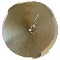
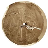
Very nice, Damia. I couldn't resist making a circular version, hope you don't mind. This is without any extra processing. Later i will look at a higher contrast version.
We just had another drive on sol 418. Phil
Attached thumbnail(s)
-------------------- ... because the Solar System ain't gonna map itself.
Also to be found posting similar content on https://mastodon.social/@PhilStooke Maps for download (free PD: https://upload.wikimedia.org/wikipedia/comm...Cartography.pdf NOTE: everything created by me which I post on UMSF is considered to be in the public domain (NOT CC, public domain) |
|
|
|
|
|
|
Apr 25 2022, 06:27 PM
Post
#19
|
||
 Member Group: Members Posts: 714 Joined: 3-January 08 Member No.: 3995 |
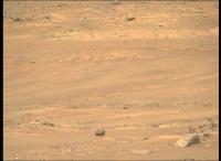
They have begun to image the light-colored beds at the base of Cape Nukshak:
|
|
|
|
|
|
|
Apr 25 2022, 07:03 PM
Post
#20
|
||
|
Solar System Cartographer Group: Members Posts: 10153 Joined: 5-April 05 From: Canada Member No.: 227 |
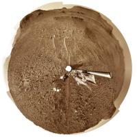
The sol 418 panorama in circular form. Another drive on sol 419! - but not very long.
Phil
-------------------- ... because the Solar System ain't gonna map itself.
Also to be found posting similar content on https://mastodon.social/@PhilStooke Maps for download (free PD: https://upload.wikimedia.org/wikipedia/comm...Cartography.pdf NOTE: everything created by me which I post on UMSF is considered to be in the public domain (NOT CC, public domain) |
|
|
|
|
|
|
Apr 25 2022, 09:08 PM
Post
#21
|
||
|
Solar System Cartographer Group: Members Posts: 10153 Joined: 5-April 05 From: Canada Member No.: 227 |
Sol 419. Not sure if we are turning to examine something interesting, or to improve helicopter communications for a new flight (or those parachute images).
Phil
-------------------- ... because the Solar System ain't gonna map itself.
Also to be found posting similar content on https://mastodon.social/@PhilStooke Maps for download (free PD: https://upload.wikimedia.org/wikipedia/comm...Cartography.pdf NOTE: everything created by me which I post on UMSF is considered to be in the public domain (NOT CC, public domain) |
|
|
|
|
|
|
Apr 25 2022, 09:44 PM
Post
#22
|
|
|
Senior Member Group: Members Posts: 2998 Joined: 30-October 04 Member No.: 105 |
I presume that we've driven up on that Nukshak plateau.
-------------------- |
|
|
|
|
Apr 25 2022, 10:03 PM
Post
#23
|
|
|
Member Group: Members Posts: 362 Joined: 13-April 06 From: Malta Member No.: 741 |
From the latest rover position it looks like Percy is still on the crater floor but probably plans to access the lower strata of the delta plateau from this location..easier access to avoid sand dunes perhaps?
|
|
|
|
|
Apr 26 2022, 02:24 AM
Post
#24
|
||
|
Senior Member Group: Members Posts: 2998 Joined: 30-October 04 Member No.: 105 |
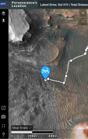
Sol 419 update of Rover's location (quick screengrab).
Attached thumbnail(s)
-------------------- |
|
|
|
|
|
|
Apr 26 2022, 09:40 AM
Post
#25
|
|
|
Senior Member Group: Members Posts: 1619 Joined: 12-February 06 From: Bergerac - FR Member No.: 678 |
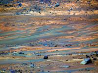
Sol 419 Navcam panoramic. I just love here that feel of climbing up a hill.
-------------------- |
|
|
|
|
Apr 26 2022, 05:48 PM
Post
#26
|
||
|
Solar System Cartographer Group: Members Posts: 10153 Joined: 5-April 05 From: Canada Member No.: 227 |
That's a very nice panorama! Thanks, Damia.
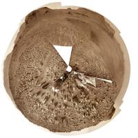
This is sol 420's view in circular form. We moved about 60 m north to a rocky ledge. Phil
-------------------- ... because the Solar System ain't gonna map itself.
Also to be found posting similar content on https://mastodon.social/@PhilStooke Maps for download (free PD: https://upload.wikimedia.org/wikipedia/comm...Cartography.pdf NOTE: everything created by me which I post on UMSF is considered to be in the public domain (NOT CC, public domain) |
|
|
|
|
|
|
Apr 26 2022, 07:41 PM
Post
#27
|
||||
 Member Group: Members Posts: 665 Joined: 9-May 21 From: Germany Member No.: 9017 |
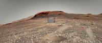
1. Sol 419 Mastcam-Z left eye filters 1 to 6 multispectral principal components false colors
2. Navcam context 3. Mastcam-Z left eye filter 0 (RGB) raw image for comparison 1
|
|||
|
|
|
|||
|
Apr 26 2022, 08:16 PM
Post
#28
|
|
 Member Group: Members Posts: 823 Joined: 9-September 17 From: UK Member No.: 8241 |
-------------------- |
|
|
|
|
Apr 26 2022, 10:07 PM
Post
#29
|
|
 Member Group: Members Posts: 699 Joined: 3-December 04 From: Boulder, Colorado, USA Member No.: 117 |
Spectacular! And welcome to the forum.
John |
|
|
|
|
Apr 27 2022, 02:38 AM
Post
#30
|
|
|
Member Group: Members Posts: 823 Joined: 9-September 17 From: UK Member No.: 8241 |
-------------------- |
|
|
|
|

|
Lo-Fi Version | Time is now: 27th April 2024 - 01:42 PM |
|
RULES AND GUIDELINES Please read the Forum Rules and Guidelines before posting. IMAGE COPYRIGHT |
OPINIONS AND MODERATION Opinions expressed on UnmannedSpaceflight.com are those of the individual posters and do not necessarily reflect the opinions of UnmannedSpaceflight.com or The Planetary Society. The all-volunteer UnmannedSpaceflight.com moderation team is wholly independent of The Planetary Society. The Planetary Society has no influence over decisions made by the UnmannedSpaceflight.com moderators. |
SUPPORT THE FORUM Unmannedspaceflight.com is funded by the Planetary Society. Please consider supporting our work and many other projects by donating to the Society or becoming a member. |
|