The Top of Vera Rubin Ridge Part 2, Site 67-73, sol 1944-2297, 24 Jan 2018-22 Jan 2019 |

  |
The Top of Vera Rubin Ridge Part 2, Site 67-73, sol 1944-2297, 24 Jan 2018-22 Jan 2019 |
 Jun 24 2018, 07:40 PM Jun 24 2018, 07:40 PM
Post
#331
|
|
 Senior Member  Group: Members Posts: 2428 Joined: 30-January 13 From: Penang, Malaysia. Member No.: 6853 |
QUOTE (djellison @ Jun 25 2018, 01:09 AM)  See attached - about 1,150 meters. Perfect... Thank you 
|
 |
 
|
|
Jun 24 2018, 10:18 PM
Post
#332
|
||
|
Senior Member Group: Members Posts: 2428 Joined: 30-January 13 From: Penang, Malaysia. Member No.: 6853 |
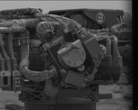
Several bayer encoded images of the MAHLI camera were acquired on 2090 using both mastcams, hope it's just a check to see if the cover is tightly closed and not an issue. The weekend plan did not get released yet, hopefully there is some info in there when it eventually gets published.
|
|
|
|
|
|
|
Jun 24 2018, 10:26 PM
Post
#333
|
||
|
Solar System Cartographer Group: Members Posts: 10151 Joined: 5-April 05 From: Canada Member No.: 227 |
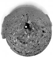
Jan's panorama from sol 2089 in circular format. You can see the new tracks skirting the rock Duluth.
Phil
-------------------- ... because the Solar System ain't gonna map itself.
Also to be found posting similar content on https://mastodon.social/@PhilStooke Maps for download (free PD: https://upload.wikimedia.org/wikipedia/comm...Cartography.pdf NOTE: everything created by me which I post on UMSF is considered to be in the public domain (NOT CC, public domain) |
|
|
|
|
|
|
Jun 26 2018, 07:58 PM
Post
#334
|
||
|
Senior Member Group: Members Posts: 2819 Joined: 22-April 05 From: Ridderkerk, Netherlands Member No.: 353 |
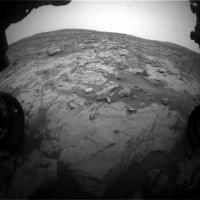
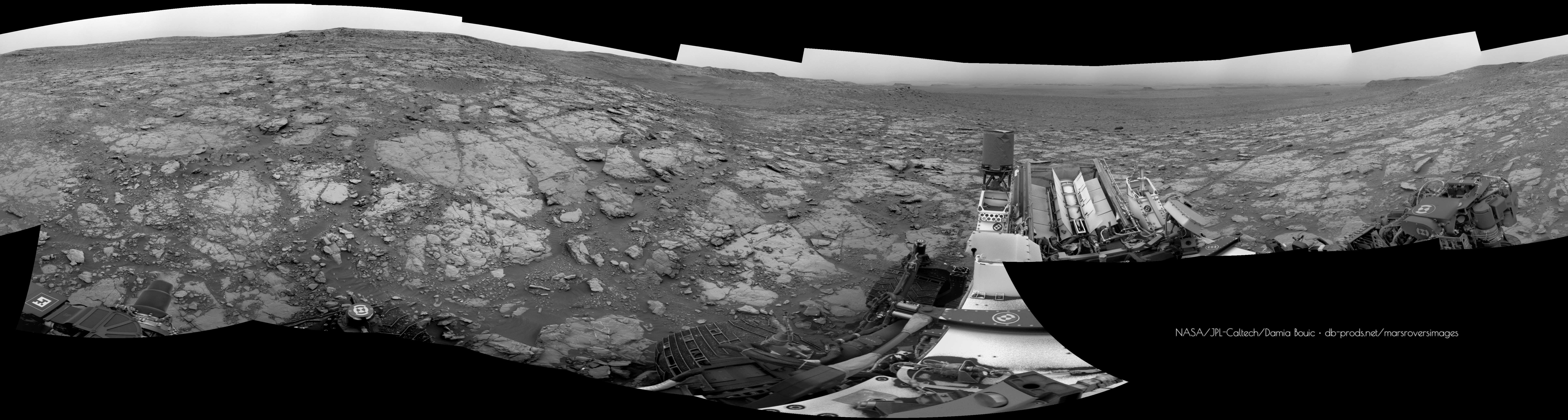
The Navcam L view on Sol 2092.
Jan van Driel
|
|
|
|
|
|
|
Jun 27 2018, 02:30 AM
Post
#335
|
|
|
Senior Member Group: Members Posts: 1074 Joined: 21-September 07 From: Québec, Canada Member No.: 3908 |
Sol 2092 Lmastcam:
|
|
|
|
|
Jun 27 2018, 06:24 AM
Post
#336
|
||
|
Solar System Cartographer Group: Members Posts: 10151 Joined: 5-April 05 From: Canada Member No.: 227 |
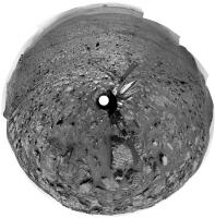
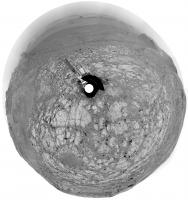
Jan's panorama for sol 2092 in circular form. The tracks are well displayed. Look to the north, just down the hill... a dark streak crosses the rocky terrain. Most likely a dust devil track! It wasn't there 2 days ago (check my last circular pan), and DD tracks are not seen usually in Gale because, people have said, the surface is not very dusty. But maybe it's dustier now for obvious reasons, and a very recent DD swept the track clean.
Phil
-------------------- ... because the Solar System ain't gonna map itself.
Also to be found posting similar content on https://mastodon.social/@PhilStooke Maps for download (free PD: https://upload.wikimedia.org/wikipedia/comm...Cartography.pdf NOTE: everything created by me which I post on UMSF is considered to be in the public domain (NOT CC, public domain) |
|
|
|
|
|
|
Jun 27 2018, 09:57 PM
Post
#337
|
|
|
Senior Member Group: Members Posts: 2428 Joined: 30-January 13 From: Penang, Malaysia. Member No.: 6853 |
QUOTE (Phil Stooke @ Jun 27 2018, 02:24 PM) ...Most likely a dust devil track!..... Great eyes Phil, another advantage of your Philovision pans, the rover tracks and now DD tracks, really stand out! |
|
|
|
|
Jun 28 2018, 10:26 AM
Post
#338
|
|
 Senior Member Group: Members Posts: 1619 Joined: 12-February 06 From: Bergerac - FR Member No.: 678 |
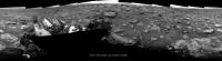
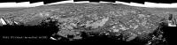
Sol 2094 Navcam panoramic. Try searching for Mt Sharp on the left part of the pan.
-------------------- |
|
|
|
|
Jun 28 2018, 10:48 AM
Post
#339
|
|
 Member Group: Members Posts: 888 Joined: 15-June 09 From: Lisbon, Portugal Member No.: 4824 |
Great work, as always! And the DD track is clearly visible, whereas Mount Sharp has almost disappeared in the dust...
Fernando |
|
|
|
|
Jun 28 2018, 06:51 PM
Post
#340
|
||
|
Solar System Cartographer Group: Members Posts: 10151 Joined: 5-April 05 From: Canada Member No.: 227 |
Damia's panorama in circular form. We will lose the view of the probable DD track soon as we go south.
Phil
-------------------- ... because the Solar System ain't gonna map itself.
Also to be found posting similar content on https://mastodon.social/@PhilStooke Maps for download (free PD: https://upload.wikimedia.org/wikipedia/comm...Cartography.pdf NOTE: everything created by me which I post on UMSF is considered to be in the public domain (NOT CC, public domain) |
|
|
|
|
|
|
Jun 28 2018, 11:15 PM
Post
#341
|
|
|
Senior Member Group: Members Posts: 2428 Joined: 30-January 13 From: Penang, Malaysia. Member No.: 6853 |
With the last drive did the rover cross back into the Torridon quadrangle?
|
|
|
|
|
Jun 28 2018, 11:18 PM
Post
#342
|
|
|
Solar System Cartographer Group: Members Posts: 10151 Joined: 5-April 05 From: Canada Member No.: 227 |
Yes, I think it did, just.
Phil -------------------- ... because the Solar System ain't gonna map itself.
Also to be found posting similar content on https://mastodon.social/@PhilStooke Maps for download (free PD: https://upload.wikimedia.org/wikipedia/comm...Cartography.pdf NOTE: everything created by me which I post on UMSF is considered to be in the public domain (NOT CC, public domain) |
|
|
|
|
Jun 29 2018, 01:50 AM
Post
#343
|
||
|
Senior Member Group: Members Posts: 2428 Joined: 30-January 13 From: Penang, Malaysia. Member No.: 6853 |
A long drive on sol 2095, probably taking advantage of the improved terrain after the last drive
I can't work out the direction yet, I'll need a few more images, but the plan mentioned south...
|
|
|
|
|
|
|
Jun 30 2018, 07:47 PM
Post
#344
|
||
|
Senior Member Group: Members Posts: 2819 Joined: 22-April 05 From: Ridderkerk, Netherlands Member No.: 353 |
The Navcam L view on Sol 2095.
Jan van Driel
|
|
|
|
|
|
|
Jul 1 2018, 11:38 PM
Post
#345
|
|
|
Senior Member Group: Members Posts: 1043 Joined: 17-February 09 Member No.: 4605 |
QUOTE (HSchirmer @ Jan 26 2018, 12:33 AM) Since Phyllo means "sheets/dough" and silica means hard, are we going to get placenames based on pastries? Well Opportunity had blueberry muffins so cherry tart or similar would seem appropriate for Curiosity. |
|
|
|
|

|
Lo-Fi Version | Time is now: 25th April 2024 - 01:29 AM |
|
RULES AND GUIDELINES Please read the Forum Rules and Guidelines before posting. IMAGE COPYRIGHT |
OPINIONS AND MODERATION Opinions expressed on UnmannedSpaceflight.com are those of the individual posters and do not necessarily reflect the opinions of UnmannedSpaceflight.com or The Planetary Society. The all-volunteer UnmannedSpaceflight.com moderation team is wholly independent of The Planetary Society. The Planetary Society has no influence over decisions made by the UnmannedSpaceflight.com moderators. |
SUPPORT THE FORUM Unmannedspaceflight.com is funded by the Planetary Society. Please consider supporting our work and many other projects by donating to the Society or becoming a member. |
|