LROC news and images |

  |
LROC news and images |
 Jul 30 2009, 12:26 PM Jul 30 2009, 12:26 PM
Post
#91
|
||
|
Member  Group: Members Posts: 156 Joined: 22-May 09 From: Ireland Member No.: 4792 |
Thanks Phil
OT: The half-covered crater just on the boundary in the Frigoris Image is simply excellent at very high res...WOW. John PS...I see the color camera is now working fine...yeah...sacrilegious, I know 
|
|
 |
 
|
|
|
Jul 30 2009, 05:30 PM
Post
#92
|
|
|
Member Group: Members Posts: 813 Joined: 29-December 05 From: NE Oh, USA Member No.: 627 |
QUOTE (Phil Stooke @ Jul 29 2009, 08:49 AM)  This is a tiny detail from the upper wall of Burg crater in the latest LROC image. Nice dust streamers - I don't recall anything like this in Apollo or Lunar Orbiter images. Phil The Moon ( or Selene - I just do not feel 'the Moon' does her justice) sure ain't boring... Every time we increase resolution on a planet/moon, a whole new world pops into view. LROC will help reveal processes that operate on a large, airless, volatile free body. How exactly do electrostatic and exospheric efffects operate, long term and short? I expect the unexpected. WOW.. Craig |
|
|
|
| Guest_Zvezdichko_* |
Aug 4 2009, 09:40 AM
Post
#93
|
|
Guests |
|
|
|
|
| Guest_Zvezdichko_* |
Aug 5 2009, 02:59 PM
Post
#94
|
|
Guests |
|
|
|
|
|
Aug 7 2009, 06:47 PM
Post
#95
|
||
|
Junior Member Group: Members Posts: 62 Joined: 30-July 09 Member No.: 4887 |
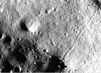
QUOTE (Zvezdichko @ Aug 5 2009, 02:59 PM) Although its not possible to see in the LRO image browser, this image has many boulder tracks in it if you download the tiff and adjust the contrast/brightness appropriately. I have attached a sample. |
|
|
|
|
|
| Guest_Zvezdichko_* |
Aug 7 2009, 06:53 PM
Post
#96
|
|
Guests |
Yes! This sample is just another example of rock movement.
Because this is what I think has happened while looking at these images. We can clearly seen the trails. But what could have caused this? The Moon is a dead body for millions of years. |
|
|
|
|
Aug 7 2009, 08:17 PM
Post
#97
|
|
|
Solar System Cartographer Group: Members Posts: 10146 Joined: 5-April 05 From: Canada Member No.: 227 |
Seismic shaking caused by nearby impacts?
Phil -------------------- ... because the Solar System ain't gonna map itself.
Also to be found posting similar content on https://mastodon.social/@PhilStooke NOTE: everything created by me which I post on UMSF is considered to be in the public domain (NOT CC, public domain) |
|
|
|
|
Aug 8 2009, 01:47 PM
Post
#98
|
|
 Member Group: Members Posts: 399 Joined: 28-August 07 From: San Francisco Member No.: 3511 |
Have they mostly slid or tumbled ? Some tracks remind me of Spirits' RF
Eoin -------------------- 'She drove until the wheels fell off...'
|
|
|
|
|
Aug 8 2009, 11:16 PM
Post
#99
|
|
|
Member Group: Members Posts: 315 Joined: 1-October 06 Member No.: 1206 |
Pretty weird seeing craters on the tops of those Tsiolkovsky ejecta blocks. Obviously you know they must be there, but it just seems odd seeing them in 'solid rock' compared to the surrounding regolith.
p |
|
|
|
|
Aug 9 2009, 03:55 PM
Post
#100
|
|
|
Junior Member Group: Members Posts: 62 Joined: 30-July 09 Member No.: 4887 |
QUOTE (Zvezdichko @ Aug 7 2009, 06:53 PM) Yes! This sample is just another example of rock movement. Because this is what I think has happened while looking at these images. We can clearly seen the trails. But what could have caused this? The Moon is a dead body for millions of years. Back in the old Lunar Orbiter days they developed alot of theories for why the boulders eventually rolled downhill. I will have to did up the old reports. I recall thermal cycling and impacts of meteors causing tremors factored into it. My main interest in these is that they permit the deduction of regolith mechanical properties without having to land there. We don't really have any instruments to deduce these mechanical properties remotely. Landers or rovers could of course, but that is way too costly. During the Lunar Orbiter days, they found a slew of these in the very high resolution images (~1-3m/pixel, which only covered a small percentage of the surface) and derived regolith properties in preparation for Apollo landings. One of the concerns about the regolith is how much variation there is in its properties over the entire surface. Since interest exists for the near polar regions, it would be nice to be assured the properties are the same there as near the equator. Rolling boulders should be distributed fairly equally over the surface and if there aren't many near the poles, that is significant. Also, looking at these images, I had supposed there would be many more rocks and boulders (which would be especially visible at some of the shallow Sun elevations for the images), but there seems to be many more craters than boulders (~an order of magnitude). Does this make sense? |
|
|
|
|
Aug 9 2009, 04:22 PM
Post
#101
|
|
|
Solar System Cartographer Group: Members Posts: 10146 Joined: 5-April 05 From: Canada Member No.: 227 |
James, look at the Apollo or Surveyor images taken on the surface and you will see that rocks are actually quite rare, outside of specific locations: the rims of fresh craters, or at the foot of a slope where they collect after rolling. Apollo images (later missions especially) are in fact a bit misleading, since many sampling stations were chosen to be in groups of rocks (Apollo 17 Station 5 and Station 6, or Apollo 16 at North Ray being good examples). I've been having this discussion with some Google Lunar X Prize teams, who have greatly exaggerated the danger of landing on rocks and maybe under-rated the danger of landing on sloping crater walls.
To me the LROC images match very closely what the surface images lead me to expect. Phil -------------------- ... because the Solar System ain't gonna map itself.
Also to be found posting similar content on https://mastodon.social/@PhilStooke NOTE: everything created by me which I post on UMSF is considered to be in the public domain (NOT CC, public domain) |
|
|
|
|
Aug 9 2009, 05:03 PM
Post
#102
|
|
 Member Group: Members Posts: 547 Joined: 1-May 06 From: Scotland (Ecosse, Escocia) Member No.: 759 |
QUOTE (Zvezdichko @ Aug 7 2009, 07:53 PM) This sample is just another example of rock movement. We can clearly seen the trails. But what could have caused this? The Moon is a dead body for millions of years. Don't forget that on Earth we have incremental boulder creep downslope, as well as rolling boulders. These are seen as "ploughing boulders" in mountain areas, which leave a trench behind them in the soil as they move downhill. In Scotland at least, this thought to be the result of freezing and thawing effects since the end of the last Ice Age, circa 10,000 years ago. Scottish mountain boulder movement On the Moon, perhaps thermal expansion and contraction of the moving rock could offer a mechanism. As the rock warms up in the lunar day, it will be easier to expand downhill where movement is less constrained by the regolith slope, than uphill. The net effect over millions of years could be the apparent movement and tracks we now see - a much slower effect than the Earth mountain analogy, but with a similar outcome. |
|
|
|
|
Aug 10 2009, 01:25 PM
Post
#103
|
|
|
Junior Member Group: Members Posts: 62 Joined: 30-July 09 Member No.: 4887 |
QUOTE (Phil Stooke @ Aug 9 2009, 04:22 PM) James, look at the Apollo or Surveyor images taken on the surface and you will see that rocks are actually quite rare, outside of specific locations: the rims of fresh craters, or at the foot of a slope where they collect after rolling. Apollo images (later missions especially) are in fact a bit misleading, since many sampling stations were chosen to be in groups of rocks (Apollo 17 Station 5 and Station 6, or Apollo 16 at North Ray being good examples). I've been having this discussion with some Google Lunar X Prize teams, who have greatly exaggerated the danger of landing on rocks and maybe under-rated the danger of landing on sloping crater walls. To me the LROC images match very closely what the surface images lead me to expect. Phil I thought Apollo sites were selected to reduce landing risk by picking flat, hazard free places. What is your estimate of frequency of 1 m diameter boulders? 1 per square kilometer? 1 per 100m^2? |
|
|
|
|
Aug 10 2009, 04:04 PM
Post
#104
|
|
|
Solar System Cartographer Group: Members Posts: 10146 Joined: 5-April 05 From: Canada Member No.: 227 |
The Apollo landing sites were rock-free to the extent possible, but the sampling stations were often at much more interesting and hazardous locations. Nobody would try to land on the rocky rim of Camelot crater or North Ray.
But as an excellent example, consider Surveyor 7, which landed on the ejecta of a fresh impact crater, Tycho. The surface images show rocks, but most of the surface is fairly rock-free. Here's an image of it: http://www.unmannedspaceflight.com/index.p...ost&id=9690 Rock distributions - just guesses: On a typical mare site I would guess 50 to 100 1m rocks per square km, but heavily concentrated in the rim deposits of fresh craters. Away from those craters, only 5 to 10 per square km. On typical highland terrain, maybe 25% of those figures. Phil -------------------- ... because the Solar System ain't gonna map itself.
Also to be found posting similar content on https://mastodon.social/@PhilStooke NOTE: everything created by me which I post on UMSF is considered to be in the public domain (NOT CC, public domain) |
|
|
|
|
Aug 14 2009, 12:14 PM
Post
#105
|
|
|
Solar System Cartographer Group: Members Posts: 10146 Joined: 5-April 05 From: Canada Member No.: 227 |
LRO has done a full longitude circuit of the Moon since the release of the Apollo site images... so an Apollo 12 release may not be too far away. Not to mention a few other sites if we're lucky. The sun will be noticeably higher now.
Phil -------------------- ... because the Solar System ain't gonna map itself.
Also to be found posting similar content on https://mastodon.social/@PhilStooke NOTE: everything created by me which I post on UMSF is considered to be in the public domain (NOT CC, public domain) |
|
|
|
|

|
Lo-Fi Version | Time is now: 19th April 2024 - 08:29 PM |
|
RULES AND GUIDELINES Please read the Forum Rules and Guidelines before posting. IMAGE COPYRIGHT |
OPINIONS AND MODERATION Opinions expressed on UnmannedSpaceflight.com are those of the individual posters and do not necessarily reflect the opinions of UnmannedSpaceflight.com or The Planetary Society. The all-volunteer UnmannedSpaceflight.com moderation team is wholly independent of The Planetary Society. The Planetary Society has no influence over decisions made by the UnmannedSpaceflight.com moderators. |
SUPPORT THE FORUM Unmannedspaceflight.com is funded by the Planetary Society. Please consider supporting our work and many other projects by donating to the Society or becoming a member. |
|