Traverse to the Delta, sols 379-414, 15 Mar 2022- 21 Apr 2022 |

  |
Traverse to the Delta, sols 379-414, 15 Mar 2022- 21 Apr 2022 |
 Apr 14 2022, 09:35 AM Apr 14 2022, 09:35 AM
Post
#121
|
|
|
Junior Member  Group: Members Posts: 75 Joined: 8-July 15 Member No.: 7566 |
QUOTE (tau @ Apr 13 2022, 09:35 PM)  A comparison with an image from a greater distance on sol 402 shows that this is only a perspective effect, albeit a very impressive one. When I first saw the sol 406 image, my eyes were fooled too. The conglomerate-sandstone contact is - at least in this place - nearly horizontal. The digital terrain model indicates an inclination of the slope below the conglomerate of 30° to almost 40° to the east-southeast. Great analysis. I think you're right, it is horizontal, not dipping after all. Looking at the larger scale outcrop as well, this unit forms a horizontal / near-horizontal 'cap rock', which isn't really consistent with the idea of a bed dipping at ~30 degrees. I hope we get more images of this deposit (maybe from when we're higher up, climbing the delta?) so we can better see the contact - which I expect will be highly erosional - and also look for things like imbrication. RE Julius - while you're right that there are flashy deposits which could be indicative of episodes of higher rainfall e.g. volcanic eruptions, impact events, orbital cycles etc the bulk of the delta likely wasn't formed this way. Based on the excellently preserved lateral migration surfaces on the delta top due to channel migration, Lapôtre and Ielpi 2020 estimate an age of delta formation of ~380,000 years, and that's based on what we see today which is a highly eroded delta. Isolated outcrops like Kodiak and Santa Cruz suggest there is a hell of a lot of delta & lake sediments that were once present but have since eroded away. So at a minimum, the lake persisted for many thousands of years. Furthermore, given that there is an outflow river channel a full 100m higher in elevation than the delta (Mangold et al. 2021), there is a whole era of this lake's history that the delta does not record: water levels were at one point 100 metres higher so the delta was either drowned, buried, or hadn't formed yet. RE StargazeInWonder - the planned traverse route may show 6-10 climbs but this will be a very slow affair, it will not take 6 solds more like 6 months. This is because upon arrival at three forks, the next science campaign will begin. Like during the Seitah campaign, we'll return to a MUCH slower traverse to do as much science as possible. The base of the delta is the only opportunity in the entire mission we'll get to study possible prodelta mudstones. Those are of enormous scientific interest because not only do they have the highest potential to preserve organic biosignatures, but they also have the best chance of preserving macrofossils i.e. stromatolites. IF stromatolites were present in the Jezero lake, and IF they were preserved in accessible rocks, then we're likely to find them in the next few weeks and months (which is quite exciting IMO). Higher up, on the delta top, the rocks are fluvial in nature and are of less astrobiological potential. While the rover takes its time doing lots of field geology and core-taking, Ingenuity will have caught up and will be scouting ahead up the delta in order to aid the rover planners in finding their future route to ascend up. |
 |
 
|
|
Apr 14 2022, 09:56 PM
Post
#122
|
||
|
Solar System Cartographer Group: Members Posts: 10164 Joined: 5-April 05 From: Canada Member No.: 227 |
Sol 408 circular panorama. Those linear troughs, some of them resembling the 'raised ridges' we saw before, are no obstacle at all to driving.
Phil
-------------------- ... because the Solar System ain't gonna map itself.
Also to be found posting similar content on https://mastodon.social/@PhilStooke Maps for download (free PD: https://upload.wikimedia.org/wikipedia/comm...Cartography.pdf NOTE: everything created by me which I post on UMSF is considered to be in the public domain (NOT CC, public domain) |
|
|
|
|
|
|
Apr 15 2022, 05:23 PM
Post
#123
|
|
 Member Group: Members Posts: 648 Joined: 9-May 05 From: Subotica Member No.: 384 |
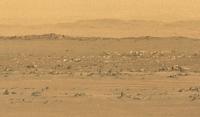
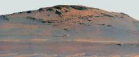
Kodiak Hill imaged by Mars Perseverances Mastcam-Z.camera on sol 409. The approximate distance is 750m.
The last time Mastcam-Z looked at Kodiak it was over 3 km away, on sol 388.  Mars2020 Panorama Sol 409 by Tomislav Bandin, on Flickr Mars2020 Panorama Sol 409 by Tomislav Bandin, on Flickr
-------------------- The scientist does not study nature because it is useful; he studies it because he delights in it, and he delights in it because it is beautiful.
Jules H. Poincare My "Astrophotos" gallery on flickr... |
|
|
|
|
Apr 15 2022, 07:32 PM
Post
#124
|
|
 Member Group: Members Posts: 810 Joined: 3-June 04 From: Brittany, France Member No.: 79 |
Kodiak Hill imaged by Navcam Left camera on sol 409, at 3:20 pm LMST.
-------------------- |
|
|
|
|
Apr 15 2022, 08:29 PM
Post
#125
|
|
|
Member Group: Members Posts: 810 Joined: 3-June 04 From: Brittany, France Member No.: 79 |
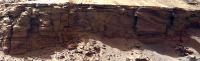
My take on the Mastcam-Z Left mosaic of sol 409 and a cropped version centered on the strata. We see nice tilted strata.
-------------------- |
|
|
|
|
Apr 15 2022, 09:24 PM
Post
#126
|
||
|
Solar System Cartographer Group: Members Posts: 10164 Joined: 5-April 05 From: Canada Member No.: 227 |
Sol 409 circular panorama. A very cool place.
Phil
-------------------- ... because the Solar System ain't gonna map itself.
Also to be found posting similar content on https://mastodon.social/@PhilStooke Maps for download (free PD: https://upload.wikimedia.org/wikipedia/comm...Cartography.pdf NOTE: everything created by me which I post on UMSF is considered to be in the public domain (NOT CC, public domain) |
|
|
|
|
|
|
Apr 16 2022, 09:19 AM
Post
#127
|
||||
 Senior Member Group: Members Posts: 1088 Joined: 19-February 05 From: Close to Meudon Observatory in France Member No.: 172 |
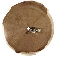
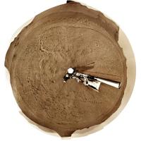
Sol 410 : the backshell and its parachute seen again !
Maybe also with the debris field from the SkyCrane impact  It should be nice to take also in the near future some zoomed pictures on this hardware to gain more detail
|
|||
|
|
|
|||
|
Apr 16 2022, 01:53 PM
Post
#128
|
|||
 Member Group: Members Posts: 670 Joined: 9-May 21 From: Germany Member No.: 9017 |
Sol 409 Mastcam-Z mosaic of Kodiak with enhanced colors and two "marsonauts" for scale, and an enlarged detail.
|
||
|
|
|
||
|
Apr 17 2022, 06:25 AM
Post
#129
|
|
|
Senior Member Group: Members Posts: 1044 Joined: 17-February 09 Member No.: 4605 |
QUOTE (Saturns Moon Titan @ Apr 14 2022, 09:35 AM) RE Julius - while you're right that there are flashy deposits which could be indicative of episodes of higher rainfall e.g. volcanic eruptions, impact events, orbital cycles etc the bulk of the delta likely wasn't formed this way. Based on the excellently preserved lateral migration surfaces on the delta top due to channel migration, Lapôtre and Ielpi 2020 estimate an age of delta formation of ~380,000 years, and that's based on what we see today which is a highly eroded delta. Isolated outcrops like Kodiak and Santa Cruz suggest there is a hell of a lot of delta & lake sediments that were once present but have since eroded away. So at a minimum, the lake persisted for many thousands of years. Furthermore, given that there is an outflow river channel a full 100m higher in elevation than the delta (Mangold et al. 2021), there is a whole era of this lake's history that the delta does not record: water levels were at one point 100 metres higher so the delta was either drowned, buried, or hadn't formed yet. Estimates for the timescale for delta formation vary from decades (Francesco Salese et al) to as you say, millenia. But the Neretva Vallis knickpoint level with the inner crater wall, which could be taken as the beginning of the delta, is the same elevation as the bottom of the outflow channel penetration of the crater wall. Assuming the formation of the outflow breach was due to overtopping, the lake level would have been over 200 metres above the current delta and once overtopped the flow of a few hundred cubic kilometres of water would have resulted in rapid erosion of the gap. While not definitive the implication is that the bulk of the delta as we see it was formed after the breach had lowered the lake level and bounded the depth. |
|
|
|
|
Apr 17 2022, 09:31 AM
Post
#130
|
|
 Senior Member Group: Members Posts: 1619 Joined: 12-February 06 From: Bergerac - FR Member No.: 678 |
QUOTE (Phil Stooke @ Apr 15 2022, 11:24 PM) A very cool place. Indeed Sol 409 panorama :  Interactive version here, because some sky were shot this Sol : 
-------------------- |
|
|
|
|
Apr 18 2022, 05:03 PM
Post
#131
|
||
|
Member Group: Members Posts: 670 Joined: 9-May 21 From: Germany Member No.: 9017 |
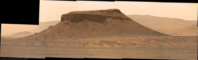
Sol 411 Mastcam-Z mosaic with enhanced colors and two "marsonauts" for scale
|
|
|
|
|
|
|
Apr 19 2022, 02:55 AM
Post
#132
|
|
 Newbie Group: Members Posts: 15 Joined: 24-July 11 From: Cumberland Plateau Member No.: 6084 |
QUOTE (tau @ Apr 18 2022, 11:03 AM) two "marsonauts" for scale Thanks for the human figures. I often struggle with size/scale perspective and the familiar shapes really help (a lot) to add value to the feeling of "being there". |
|
|
|
|
Apr 19 2022, 11:11 AM
Post
#133
|
||
 Senior Member Group: Members Posts: 2429 Joined: 30-January 13 From: Penang, Malaysia. Member No.: 6853 |
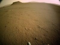
Perseverance on the move once again after pausing from driving for a few sols
Tiled Sol 413 NavCam at RMC site 22-0788
|
|
|
|
|
|
|
Apr 19 2022, 11:20 AM
Post
#134
|
|
|
Member Group: Members Posts: 362 Joined: 13-April 06 From: Malta Member No.: 741 |
What is the trough ahead of the rover, also visible on the orbital image? Polygonal terrain on the crater floor?
|
|
|
|
|
Apr 19 2022, 08:22 PM
Post
#135
|
|
|
Member Group: Members Posts: 810 Joined: 3-June 04 From: Brittany, France Member No.: 79 |
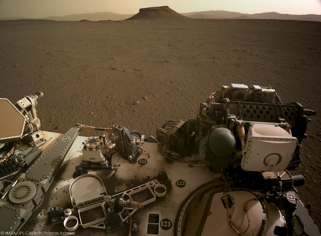
Panorama taken on sol 411 with Mastcam-Z Left. Three Forks is now clearly in sight.

-------------------- |
|
|
|
|

|
Lo-Fi Version | Time is now: 21st May 2024 - 05:05 AM |
|
RULES AND GUIDELINES Please read the Forum Rules and Guidelines before posting. IMAGE COPYRIGHT |
OPINIONS AND MODERATION Opinions expressed on UnmannedSpaceflight.com are those of the individual posters and do not necessarily reflect the opinions of UnmannedSpaceflight.com or The Planetary Society. The all-volunteer UnmannedSpaceflight.com moderation team is wholly independent of The Planetary Society. The Planetary Society has no influence over decisions made by the UnmannedSpaceflight.com moderators. |
SUPPORT THE FORUM Unmannedspaceflight.com is funded by the Planetary Society. Please consider supporting our work and many other projects by donating to the Society or becoming a member. |
|