Printable Version of Topic
Click here to view this topic in its original format
Unmanned Spaceflight.com _ Opportunity _ Victoria Crater Panoramas
Posted by: slinted Oct 3 2007, 10:44 PM
http://www.lyle.org/~markoff/victoria_panoramas.html
http://www.lyle.org/~markoff/victoria_panoramas.html
Here is a collection of calibrated color panoramas taken by Opportunity since arriving at Victoria Crater through the most recent PDS release, starting with Duck Bay and ending with the east face of Cabo Anonimo. The top of the page is a little javascript+imagemap that shows the rover location (thanks to Tesheiner's amazing route maps!) and viewing-cones of each pano (mousing over the rover location will bring up the cone and a preview image).
I'll keep this updated as new PDS releases are made available.
Posted by: volcanopele Oct 3 2007, 11:03 PM
WOW!! Those are amazing! Great job mosaicking those together!
Posted by: brellis Oct 4 2007, 12:10 AM
excellent - thank you!
Posted by: phase4 Oct 4 2007, 12:32 AM
Marvellous. Great idea!
Posted by: ElkGroveDan Oct 4 2007, 12:45 AM
These are just fantastic. I love the roll-over tool.
One issue, on the first two rollovers, Duck Bay and Cape Verde, the FOV shading is pointing backwards.
EDIT: Never mind I was inverting the shading in my mind.
Posted by: dot.dk Oct 4 2007, 12:51 AM

That's because they are very wide panoramas

Posted by: mhoward Oct 4 2007, 12:55 AM
Very nice useful tool, and of course the panoramas are fantastic.
Posted by: CosmicRocker Oct 4 2007, 02:14 AM
It's a way cool reference tool, and the panoramas are drop-dead gorgeous, not to mention, flawless. 
Posted by: nprev Oct 4 2007, 02:46 AM
 BEYOND "wow", sir; truly incredible work!!! Invaluable for those (i.e., me) that are reference-point challenged.
Thanks, Slinted! This work is just nonpariel (hope to God I spelled that correctly)
Posted by: slinted Nov 10 2007, 04:08 PM
http://www.lyle.org/~markoff/victoria_panoramas.html
http://www.lyle.org/~markoff/victoria_panoramas.html
Here's a belated thanks for the kind words and...an update!
I've added the pans/mosaics through sol 1170 from the latest PDS release, bringing the total count up to 18 images.
On top of the usual warnings about 'true color', I'll add that the sky is partially if not completely blown out to white in most of the later images. I was more concerned with getting the most out of the ground detail. Also, the http://www.lyle.org/~markoff/pdspan/oppsol1104_L456_cabocorrientes_eastface.jpg was taken in L456, not the usual L257, so its colors don't closely match the rest.
Posted by: Aussie Nov 11 2007, 09:38 AM
Like what nprev said above.
Posted by: David Nov 11 2007, 07:02 PM
Did the recent dust storms change the structure of the crater-floor dunes at all? Or are they just the same?
Posted by: vikingmars Jan 24 2011, 08:24 AM
One of the most spectacular views ever seen from Opportunity during its mission was at the "Valley without Peril" point from Sols 1130 to 1132. When I saw the NavCam images, I knew there was really something there to work on... Because the rover Drivers focused more on the foreground than on the background features, the panorama could be made only by stitching manually some images taken from those 3-sol interval... Well, you can imagine why there was a concern here for the rover Drivers : Opportunity is so close to the edge that a bad command could have sent it tumbling down the slope... There was a lot of imaging work to do because of parallax issues and I left this work for later. Last week, I decided to process the images. Here is the result. Indeed a spectacular view. Enjoy !
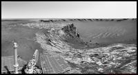
|
Posted by: Phil Stooke Jan 24 2011, 03:30 PM
Very spectacular! Maybe we should rename it 'Valley with Peril'. Excellent work.
Phil
Posted by: Nirgal Jan 24 2011, 09:11 PM
What a phantastic view: Oppy at the edge of steep martian cliffs above bizarre waves of a lake of sand ...
Another one for the MER panorama Hall of Fame, thank you
Powered by Invision Power Board (http://www.invisionboard.com)
© Invision Power Services (http://www.invisionpower.com)