Opportunity Route Map |

  |
Opportunity Route Map |
 May 4 2006, 01:32 AM May 4 2006, 01:32 AM
Post
#1306
|
|
 Senior Member  Group: Moderator Posts: 2262 Joined: 9-February 04 From: Melbourne - Oz Member No.: 16 |
Halfway from where?
Roughly looking at the map I think were pretty much halfway between Payson and 'Corner Crater' already, pretty good progress! At this rate we should be on the apron by sol 870ish by my reckoning. Not looking good for my Victoria prediction, here's hoping that Corner Crater is be interesting enough for a primary mission length stop!  James -------------------- |
 |
 
|
|
May 4 2006, 05:31 AM
Post
#1307
|
|
 Senior Member Group: Members Posts: 1229 Joined: 24-December 05 From: The blue one in between the yellow and red ones. Member No.: 618 |
QUOTE (jamescanvin @ May 3 2006, 03:32 PM)  Halfway from where? James Yup, I'd say "Corner Crater" is a very good guess for the aim-point. Indeed that blue line is looking better and better as a predicted path. I would go there first, though maybe some PI is frantic to take a look at those dark plumes to the east. But our real aim-point is down below the surface. Going down is the shortest route to our destination. 
-------------------- My Grandpa goes to Mars every day and all I get are these lousy T-shirts!
|
|
|
|
|
May 4 2006, 08:22 AM
Post
#1308
|
|
|
Senior Member Group: Moderator Posts: 4279 Joined: 19-April 05 From: .br at .es Member No.: 253 |
QUOTE (climber @ May 4 2006, 01:06 AM) Hola Tesheiner! You missed 5 sols... pero me parece que no faltaba sol en espana  James did very well indeed : he put Oppy back on YOUR track so, one more week holiday for you must be fine  I'm still on "recovery mode", climber. And yes, "no faltaba el sol". Sunny and warm days, but only the kids were brave enough to jump into the water. QUOTE (jamescanvin @ May 2 2006, 11:48 PM) Here is my estimate of Oppys position for sol 807 based on the pancam tracking data. QUOTE (jamescanvin @ May 3 2006, 11:43 PM) And again for Sol 808 James, Thanks a *lot* for keeping the route map up to date. |
|
|
|
|
May 4 2006, 02:13 PM
Post
#1309
|
|
|
Newbie Group: Members Posts: 18 Joined: 30-March 06 Member No.: 730 |
did you n otice that we're only 2 victoria diameters from the rim?
|
|
|
|
|
May 4 2006, 03:11 PM
Post
#1310
|
||
|
Senior Member Group: Moderator Posts: 4279 Joined: 19-April 05 From: .br at .es Member No.: 253 |
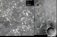
Route map, updated to sol 809.
|
|
|
|
|
|
|
May 4 2006, 03:44 PM
Post
#1311
|
|
|
Member Group: Members Posts: 178 Joined: 13-September 05 Member No.: 498 |
Welcome back Tesh (and many thanks for your continuing work).
Now that we can see the ground ahead of us, your cautious faint blue line through the dunes, which looked reasonable from the orbital image, looks unnecessarily timid. It is truly amazing how different the view is from the ground. Opportunity can probably just plough straight over the ripples that currently confront her. Once we get past that zone a new "detail window" on the route can cover Corner Crater.... |
|
|
|
|
May 4 2006, 03:49 PM
Post
#1312
|
|
|
Senior Member Group: Moderator Posts: 4279 Joined: 19-April 05 From: .br at .es Member No.: 253 |
Oppy is coincidentally at a point part of my "proposed path". That was the starting point of a route segment I thought would be quite tricky and difficult due to the "bigger dunes" seen on the MOC image.
And those "bigger dunes" are actually an optical effect ; what I thought were the dune shadows are really those cobble fields which can be clearly seen on tosol pancam images.Edited: Joffan, believe me! I didn't read your post when writing mine, actually yours wasn't there yet.
|
|
|
|
|
May 4 2006, 05:06 PM
Post
#1313
|
|
|
Member Group: Members Posts: 178 Joined: 13-September 05 Member No.: 498 |
Great minds think alike

|
|
|
|
|
May 4 2006, 06:13 PM
Post
#1314
|
|
|
Senior Member Group: Members Posts: 2998 Joined: 30-October 04 Member No.: 105 |
Tesheiner--
I'd concluded the same thing: those horrendous ripples are actually dark cobble patches that look like shadows. After the discussion about dark cobbles last week I've started marking cobble fields on a new image overlay and most of the big ripples were false alarms. I'll post that image this weekend once I double-check it. The terrain does look like it will be getting a bit dustier for a short time going downhill. This makes sense: it's the Venturi effect-- increase the effective depth of flow by lowering the land surface, the velocity decreases and the suspended/saltating material drops out. --Bill -------------------- |
|
|
|
|
May 4 2006, 09:27 PM
Post
#1315
|
|
|
Senior Member Group: Moderator Posts: 2262 Joined: 9-February 04 From: Melbourne - Oz Member No.: 16 |
QUOTE (Tesheiner @ May 4 2006, 06:22 PM) James, Thanks a *lot* for keeping the route map up to date. No problem, the least I could do. Thank *you* for keeping it up to date for every other sol! Welcome back, James -------------------- |
|
|
|
|
May 4 2006, 09:39 PM
Post
#1316
|
|
|
Solar System Cartographer Group: Members Posts: 10146 Joined: 5-April 05 From: Canada Member No.: 227 |
We are very lucky to have these continous updates - the pans as well. Thanks to all contributors!
Phil -------------------- ... because the Solar System ain't gonna map itself.
Also to be found posting similar content on https://mastodon.social/@PhilStooke NOTE: everything created by me which I post on UMSF is considered to be in the public domain (NOT CC, public domain) |
|
|
|
|
May 5 2006, 06:04 PM
Post
#1317
|
||
|
Senior Member Group: Moderator Posts: 4279 Joined: 19-April 05 From: .br at .es Member No.: 253 |
Another update to the route map -- sol 810 --, probably the last for this week.
BTW, it looks like I'll have to shift the background map again sometime during next week.
|
|
|
|
|
|
|
May 5 2006, 06:22 PM
Post
#1318
|
|
|
Senior Member Group: Members Posts: 1229 Joined: 24-December 05 From: The blue one in between the yellow and red ones. Member No.: 618 |
QUOTE (Tesheiner @ May 5 2006, 08:04 AM) Another update to the route map -- sol 810 --, probably the last for this week. BTW, it looks like I'll have to shift the background map again sometime during next week. Hee hee! Tesh, looks like you might also have to switch to a single green line instead of separate yellow and blue lines! Well done! 
-------------------- My Grandpa goes to Mars every day and all I get are these lousy T-shirts!
|
|
|
|
|
May 5 2006, 06:26 PM
Post
#1319
|
|
|
Member Group: Members Posts: 128 Joined: 5-May 04 Member No.: 74 |
QUOTE (Shaka @ May 5 2006, 06:22 PM) Hee hee! Tesh, looks like you might also have to switch to a single green line instead of separate yellow and blue lines! Well done! I think JPL is cribbing off of Tesh.
|
|
|
|
|
May 5 2006, 06:59 PM
Post
#1320
|
|
|
Senior Member Group: Members Posts: 1229 Joined: 24-December 05 From: The blue one in between the yellow and red ones. Member No.: 618 |
QUOTE (ToSeek @ May 5 2006, 08:26 AM) I think JPL is cribbing off of Tesh. Maybe off Dilo, as well! Notice the recent reference: QUOTE The team believes the rim of the crater is becoming visible in a vertically stretched image looking south. Just whose image are they talking about? I haven't seen JPL's version! 
-------------------- My Grandpa goes to Mars every day and all I get are these lousy T-shirts!
|
|
|
|
|

|
Lo-Fi Version | Time is now: 19th April 2024 - 01:32 AM |
|
RULES AND GUIDELINES Please read the Forum Rules and Guidelines before posting. IMAGE COPYRIGHT |
OPINIONS AND MODERATION Opinions expressed on UnmannedSpaceflight.com are those of the individual posters and do not necessarily reflect the opinions of UnmannedSpaceflight.com or The Planetary Society. The all-volunteer UnmannedSpaceflight.com moderation team is wholly independent of The Planetary Society. The Planetary Society has no influence over decisions made by the UnmannedSpaceflight.com moderators. |
SUPPORT THE FORUM Unmannedspaceflight.com is funded by the Planetary Society. Please consider supporting our work and many other projects by donating to the Society or becoming a member. |
|