Opportunity Route Map |

  |
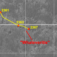
Opportunity Route Map |
 Sep 21 2010, 02:43 PM Sep 21 2010, 02:43 PM
Post
#2851
|
|
|
Senior Member  Group: Moderator Posts: 4279 Joined: 19-April 05 From: .br at .es Member No.: 253 |
|
 |
 
|
|
Sep 28 2010, 03:33 PM
Post
#2852
|
|
|
Senior Member Group: Moderator Posts: 4279 Joined: 19-April 05 From: .br at .es Member No.: 253 |
|
|
|
|
|
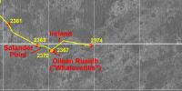
Sep 29 2010, 03:13 PM
Post
#2853
|
|
|
Senior Member Group: Moderator Posts: 4279 Joined: 19-April 05 From: .br at .es Member No.: 253 |
|
|
|
|
|
Oct 1 2010, 04:49 PM
Post
#2854
|
|
|
Senior Member Group: Moderator Posts: 4279 Joined: 19-April 05 From: .br at .es Member No.: 253 |
|
|
|
|
|
Oct 1 2010, 05:36 PM
Post
#2855
|
|
|
Senior Member Group: Members Posts: 2920 Joined: 14-February 06 From: Very close to the Pyrénées Mountains (France) Member No.: 682 |
Kinda playing around with the 13km South line, eh?
-------------------- |
|
|
|
|
Oct 1 2010, 05:49 PM
Post
#2856
|
||
|
Senior Member Group: Moderator Posts: 4279 Joined: 19-April 05 From: .br at .es Member No.: 253 |
And the 2km East too.

|
|
|
|
|
|
|
Oct 1 2010, 05:52 PM
Post
#2857
|
|
|
Solar System Cartographer Group: Members Posts: 10150 Joined: 5-April 05 From: Canada Member No.: 227 |
Ouch! Stop it, you're making me crazy!
Phil -------------------- ... because the Solar System ain't gonna map itself.
Also to be found posting similar content on https://mastodon.social/@PhilStooke NOTE: everything created by me which I post on UMSF is considered to be in the public domain (NOT CC, public domain) |
|
|
|
|
Oct 1 2010, 06:44 PM
Post
#2858
|
|
 Senior Member Group: Members Posts: 4246 Joined: 17-January 05 Member No.: 152 |
Seriously, I've often wondered something about your route maps, Tesheiner: You often show a single sol's drive in multiple segments, rather than just a straight line. On the 2377 drive, the imagery isn't even down yet, so obviously you used the downlinked drive data. I'm curious how the downlinked data is presented: do they provide the distances E/W/N/S for some number of drive segments? Do the segments always correspond to turns? It's really nice to see that level of detail in your maps. Edit: one more thing: you forgot to include the kml file with your last map update!
|
|
|
|
|
Oct 1 2010, 10:22 PM
Post
#2859
|
|
|
Senior Member Group: Moderator Posts: 4279 Joined: 19-April 05 From: .br at .es Member No.: 253 |
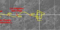
QUOTE (fredk @ Oct 1 2010, 08:44 PM)  I'm curious how the downlinked data is presented For each picture taken during a drive (e.g. slip-check navcams, post-drive pancams) the (x, y, z) position calculated by the rover itself and relative to the site origin (AR00 in this case) is provided. That's the easy part in the process of updating the route map. The "hard" one starts afterwards when the pictures are available at the exploratorium; then it's time to make a navcam mosaic, convert it to polar projection and register this picture on a HiRISE image at full resolution. The reason to do it is because the position calculated by the rover itself almost always drifts. E.g during the drive on sol 2375 I had to adjust the final position by 2.5m to the east and 1.5m to the south. It's not too much on a single drive but without these corrections and using only the "telemetry" the route would be way off after a number of driving sols. |
|
|
|
|
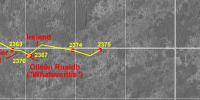
Oct 2 2010, 08:23 PM
Post
#2860
|
|
|
Solar System Cartographer Group: Members Posts: 10150 Joined: 5-April 05 From: Canada Member No.: 227 |
A wee correction to our wonderful route maps...
Ray Arvidson has a very nice presentation of Opportunity's traverse at the 4th MSL workshop site: http://marsoweb.nas.nasa.gov/landingsites/...roscopy_opt.pdf He shows Solander Point as a northern spur of Cape Tribulation. So when the tracking website indicated that an image was looking at Solander Point, it was that, and not the small crater in front of the rover at that point. Phil -------------------- ... because the Solar System ain't gonna map itself.
Also to be found posting similar content on https://mastodon.social/@PhilStooke NOTE: everything created by me which I post on UMSF is considered to be in the public domain (NOT CC, public domain) |
|
|
|
|
Oct 2 2010, 09:04 PM
Post
#2861
|
|
|
Senior Member Group: Moderator Posts: 4279 Joined: 19-April 05 From: .br at .es Member No.: 253 |
Thanks for pointing that, Phil. Maps updated.
|
|
|
|
|
Oct 2 2010, 09:31 PM
Post
#2862
|
|
|
Senior Member Group: Members Posts: 3516 Joined: 4-November 05 From: North Wales Member No.: 542 |
QUOTE (Phil Stooke @ Oct 2 2010, 09:23 PM) Ray Arvidson has a very nice presentation of Opportunity's traverse at the 4th MSL workshop site Well worth the watch. Thanks for posting that. |
|
|
|
|
Oct 3 2010, 11:15 PM
Post
#2863
|
|
|
Senior Member Group: Moderator Posts: 4279 Joined: 19-April 05 From: .br at .es Member No.: 253 |
|
|
|
|
|
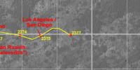
Oct 5 2010, 10:11 PM
Post
#2864
|
||
|
Senior Member Group: Moderator Posts: 4279 Joined: 19-April 05 From: .br at .es Member No.: 253 |
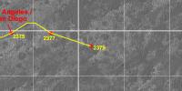
Here's a preliminary update for sol 2381. I'll probably have to adjust it slightly after the pictures are down.
 Route_Map_Sol2381.kml ( 62.04K )
Number of downloads: 394
Route_Map_Sol2381.kml ( 62.04K )
Number of downloads: 394 |
|
|
|
|
|
|
Oct 7 2010, 09:12 PM
Post
#2865
|
||
|
Senior Member Group: Moderator Posts: 4279 Joined: 19-April 05 From: .br at .es Member No.: 253 |
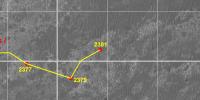
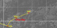
Sol 2382.
Route_Map_Sol2382.kml ( 62.38K )
Number of downloads: 381There're some data from sol 2383 but not enough to plot the current position. Perhaps tomorrow. |
|
|
|
|
|
|

|
Lo-Fi Version | Time is now: 23rd April 2024 - 06:16 PM |
|
RULES AND GUIDELINES Please read the Forum Rules and Guidelines before posting. IMAGE COPYRIGHT |
OPINIONS AND MODERATION Opinions expressed on UnmannedSpaceflight.com are those of the individual posters and do not necessarily reflect the opinions of UnmannedSpaceflight.com or The Planetary Society. The all-volunteer UnmannedSpaceflight.com moderation team is wholly independent of The Planetary Society. The Planetary Society has no influence over decisions made by the UnmannedSpaceflight.com moderators. |
SUPPORT THE FORUM Unmannedspaceflight.com is funded by the Planetary Society. Please consider supporting our work and many other projects by donating to the Society or becoming a member. |
|